
A farm town on the Quinebaug where Prudence Crandall opened her school for Black girls on the green, Moses Cleaveland was born, and the town once ran a lottery to rebuild Butts Bridge.
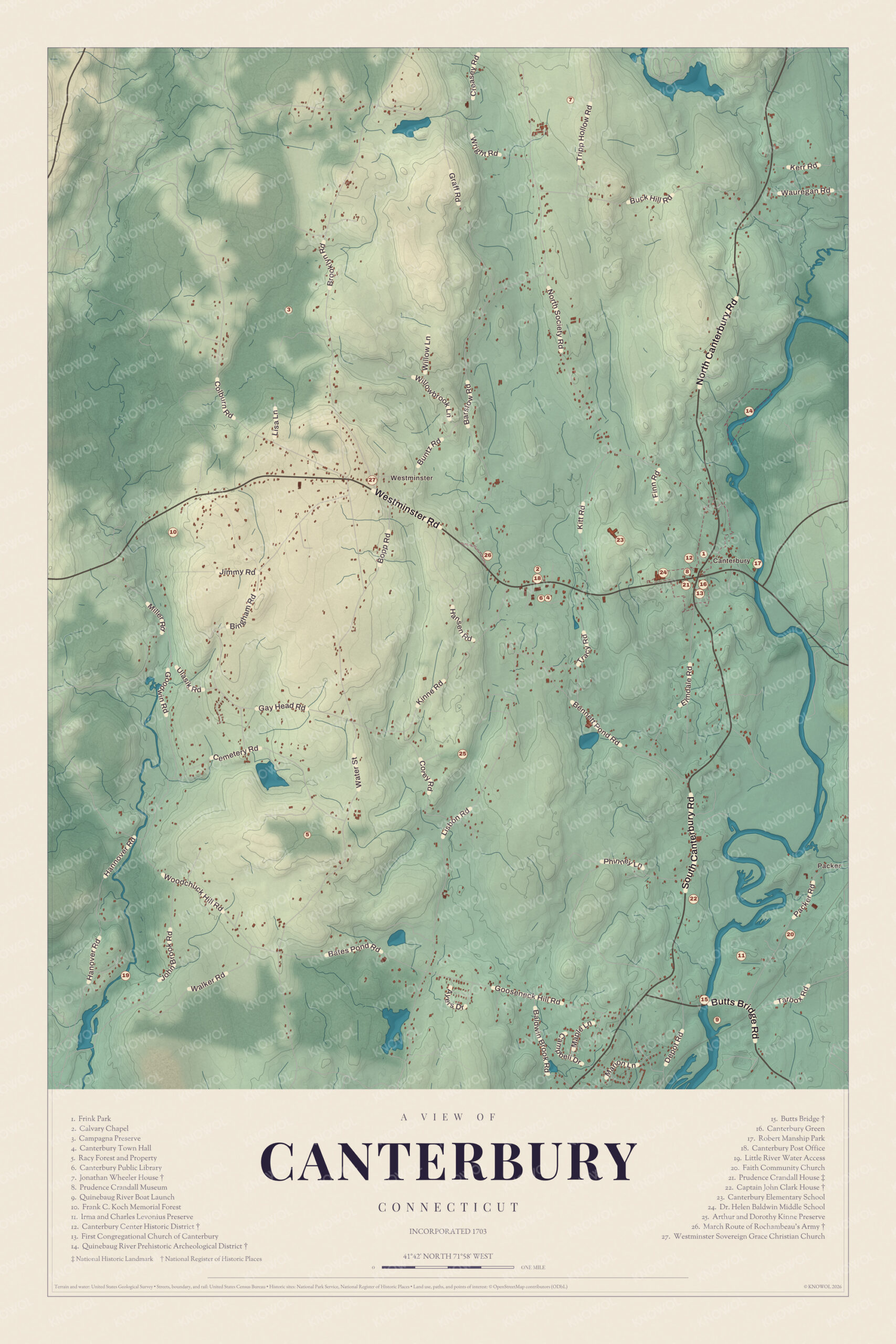
Canterbury on the map
Click the map to look closer.
Canterbury today
By KNOWOL
Shaded hills from Westminster down to Packer and the Quinebaug River, every road by name, Canterbury Green and Butts Bridge, and a guide of 27 numbered landmarks with the National Historic Landmark and the National Register sites marked.5
The story of Canterbury
The bridge Samuel Butts built
Samuel Butts came to Canterbury from Dorchester in 1706, and in 1733 he put a bridge across the Quinebaug. For years neighbors kept it up by private subscription. Then Ezra Ensworth built a dam just above it for his corn mill, and the whole valley fought the dam because it blocked the shad and salmon running upriver. Neighbors rebuilt the bridge in 1760, and the very next winter ice coming over the dam carried it off. In 1763 the Assembly ordered the town to keep a bridge there. By 1782 Canterbury was keeping up a bridge and a half over the Quinebaug, four over the Little River and six over Rowland's Brook, so it asked for a lottery to raise 250 pounds. The new Butts Bridge stood on stone piers.62789
Prudence Crandall's school
In 1831 Prudence Crandall, a teacher raised as a Quaker, bought the house on the southwest corner of the green and opened a boarding school for girls. When she admitted Sarah Harris, a Black student, white parents took their daughters out, and in 1833 she reopened the school for African American girls. A petition from Canterbury helped push the Black Law through the General Assembly, and an 1837 book says the town celebrated by ringing the bell and firing a cannon. Crandall spent a night in jail and kept teaching. In 1834, after a failed attempt to set the house on fire, opponents broke in the windows with iron bars, and she closed the school. A visitor near the end of her life found she held no grudge against the town.110111213
The church that split in two
In the Great Awakening most of Canterbury's church members became New Lights, and they wanted a minister who shared their fervor. In 1744 the county consociation settled Rev. James Cogswell anyway, the choice of the minority. The majority walked out and worshiped on their own, the first church in the colony to formally take up New Light principles. It cost families dearly. That November, Yale expelled John and Ebenezer Cleaveland for attending a Separate meeting with their parents during vacation. The Separates built a meetinghouse on the high land west of the green and kept such close watch on each other that within three years they'd cut off more than a third of their own members. About 1782 their meetinghouse was moved to the north part of town, where it stood until about 1853.1415161718
Through the years
25 moments from 1680s to today.
- 1680sEnglish colonists settle the land west of the Quinebaug, then called Peagscomsuck.1
- 1703The area is separated from Plainfield and named the Town of Canterbury.1
- 1705Three and a half acres are bought from Robert Green for a meetinghouse, the start of Canterbury Green.19
- 1733Samuel Butts builds the first Butts Bridge over the Quinebaug.2
- 1744The county consociation settles Rev. James Cogswell over the objections of most of the church, and the majority breaks away as the Separate church.14
- 1744Yale expels John and Ebenezer Cleaveland for attending a Separate meeting with their parents.16
- 1754Moses Cleaveland, later the namesake of Cleveland, Ohio, is born in Canterbury.5
- 1760About this year Jonathan Wheeler builds his brick house on North Society Road.20
- 1763After ice carries off the bridge, the Assembly orders Canterbury to build and keep a bridge at Butts Bridge.7
- 1767Families in the west of town ask for their own parish, which becomes Westminster.21
- 1781Rochambeau's French army marches through Canterbury and finds the road here the hardest of the journey.22
- 1782The town wins the right to run a lottery for 250 pounds to rebuild Butts Bridge.8
- 1786Brooklyn becomes a town, taking land from Canterbury and Pomfret.23
- 1796Canterbury opens an academy with Master John Adams in charge.24
- 1803Canterbury gets its post office.24
- 1805The house that will be Prudence Crandall's school is built on the green.10
- 1828The Packerville Baptist Church is organized.25
- 1831Prudence Crandall buys the house on the green and opens her boarding school.10
- 1833The Black Law passes, and Canterbury celebrates with the bell and a cannon. Crandall spends a night in jail.11
- 1834After attacks on the house, Crandall closes the school.12
- 1836Three cotton mills are running at Packerville.26
- 1877The town grants Prudence Crandall a small pension.1
- 1937Today's steel Butts Bridge is built after the floods of 1936.27
- 1963The third meetinghouse on the green burns on December 23. A new church goes up on the site the next year.5
- 1995The General Assembly names Prudence Crandall Connecticut's official state heroine.1
Places to see
The numbers match the landmark guide printed on the 2026 map.
- 7Jonathan Wheeler HouseNorth Society Road. Brick house of about 1760.
- 8Prudence Crandall MuseumCanterbury Green. Period rooms and a research library.Visit their website
- 12Canterbury Center Historic DistrictCanterbury Green. Houses mostly built before about 1850.
- 13First Congregational Church of CanterburyCanterbury Green. Built 1964 on the old meetinghouse site.Visit their website
- 14Quinebaug River Prehistoric Archeological DistrictWest bank of the Quinebaug. Sites going back about 6,000 years.
- 15Butts BridgeButts Bridge Road. Steel Parker truss of 1937.
- 16Canterbury GreenRoutes 169 and 14. Center of town since 1705.
- 21Prudence Crandall HouseSouthwest corner of the green. National Historic Landmark, built 1805.Visit their website
- 22Captain John Clark HouseRoute 169, south of the green. A fine example of the Canterbury style.
- 26March Route of Rochambeau's ArmyManship Road and Barstow Road. Old road lined with stone walls.
On the National Register
All 7 places in Canterbury on the National Register of Historic Places that still stand today, oldest first, and why each one matters.4
-
Quinebaug River Prehistoric Archeological District
Five sites on a terrace above the west bank of the Quinebaug, from the Late Archaic about 6,000 years ago to the time of European contact. Some of the stone found there came from distant quarries, a sign of well-established trade networks.28
-
Canterbury Center Historic District
The town center since 1705, when land for a meetinghouse was bought from Robert Green. Almost all of its houses were built before about 1850 in the Georgian, Federal and Greek Revival styles, and it takes in a Grange hall, the Finnish Hall and a library in an old one-room schoolhouse.19
-
Jonathan Wheeler House
Jonathan Wheeler came from Stonington in 1751 and built this brick house, unusual in rural Connecticut then, with end chimneys and a center hall. His descendants kept it until 1870.20
-
March Route of Rochambeau's Army: Manship Road-Barstow Road
About 1,400 feet of the road Rochambeau's French army marched in June 1781, bypassed in the 1930s and still lined with stone walls. The troops found the road in this area the hardest of their whole journey.22
-
Capt. John Clark House
Captain John Clark, a ship's captain, bought the house in 1801. With its hip roof, Palladian window and gable over the door, it's a particularly good example of the local Canterbury style, and Clark is generally credited with building the Crandall house too.29
-
Prudence Crandall House
National Historic Landmark
Here Prudence Crandall ran her school from 1831 to 1834, reopening it in 1833 for African American girls. A 1981 study found about 95 percent of the building unchanged since her day, and it's now the Prudence Crandall Museum.10
-
Butts Bridge
A 231-foot steel Parker truss built after the floods of 1936, at least the fourth bridge in this area on the old road between Norwich and Plainfield. Traces of the abutments of the bridge it replaced survive just upstream.27
In their words
“Few country towns could boast such social attractions.”
History of Windham County, Connecticut (1874), on the families around Canterbury Green30
“Canterbury Green is a beautiful, restful spot with the old church and lawn situated at the highest pinnacle.”
Mrs. Clinton Frink, in A modern history of Windham County, 192031
“just a little ahead of the times”
Prudence Crandall on herself, late in life, as a visitor from Packerville remembered it, 192013
Nearby towns
Sources
- Canterbury, Connecticut, Wikipedia
- History of Windham County, Connecticut (1874), on Samuel Butts' bridge and Ensworth's dam, Internet Archive
- History of Windham County, Connecticut (1889), on Canterbury in 1800, Internet Archive
- National Register of Historic Places listings in Windham County, Connecticut, Wikipedia
- Map of Canterbury, Connecticut in 2026, KNOWOL (USGS elevation, Census Bureau roads)
- History of Windham County, Connecticut (1874), on Canterbury's first settlers, Internet Archive
- History of Windham County, Connecticut (1889), on the act of 1763, Internet Archive
- History of Windham County, Connecticut (1889), on the Butts Bridge lottery, Internet Archive
- The public records of the State of Connecticut (1894), on the Butts Bridge lottery, Internet Archive
- Prudence Crandall Museum, Wikipedia
- Connecticut historical collections (1837), on Canterbury, Internet Archive
- The historical, statistical and industrial review of the state of Connecticut (1884), on Prudence Crandall's school, Internet Archive
- A modern history of Windham County, Connecticut (1920), on Prudence Crandall and Packerville, Internet Archive
- The historical, statistical and industrial review of the state of Connecticut (1884), on the Canterbury church controversy, Internet Archive
- History of Windham County, Connecticut (1874), on the Separate church, Internet Archive
- The separates; or, Strict Congregationalists of New England (1902), on the Cleaveland brothers, Internet Archive
- History of Windham County, Connecticut (1889), on the Separate church, Internet Archive
- The separates; or, Strict Congregationalists of New England (1902), on the North Church, Internet Archive
- Canterbury Center Historic District, Wikipedia
- Jonathan Wheeler House, Wikipedia
- History of Windham County, Connecticut (1874), on the division of the First society, Internet Archive
- March Route of Rochambeau's Army: Manship Road-Barstow Road, Wikipedia
- The public records of the State of Connecticut (1894), on the new town of Brooklyn, Internet Archive
- A modern history of Windham County, Connecticut (1920), on Canterbury after the Revolution, Internet Archive
- A modern history of Windham County, Connecticut (1920), on the Packerville Baptist Church, Internet Archive
- Annual report of the Bureau of Labor Statistics of the State of Connecticut, industrial history of Canterbury (text runs to 1901), Internet Archive
- Butts Bridge, Wikipedia
- Quinebaug River Prehistoric Archeological District, Wikipedia
- Capt. John Clark House, Wikipedia
- History of Windham County, Connecticut (1874), on Canterbury Green in the 1830s, Internet Archive
- A modern history of Windham County, Connecticut (1920), Mrs. Clinton Frink on Canterbury, Internet Archive