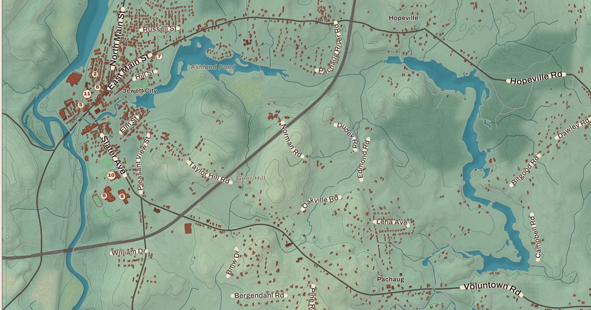
If you grew up in Griswold, whether in Jewett City or out toward Hopeville Pond, you’ll find your town on this map just as it stands in 2026. Look for your road. Hopeville Road, Bitgood Road, Forest Road, Voluntown Road, Popple Bridge Road, Cook Hill Road, Crary Road, Burton Road, Patrick Road, Cedar Lane and the Shetucket Turnpike are all printed by name, along with many more.
Griswold is in New London County, at the northeastern edge of the county where the Pachaug and Quinebaug rivers flow.
KNOWOL made this map in 2026 from public survey data, and gave it the look of an old atlas. The shaded hills, from Clayville and Jewett City out to Hopeville Pond and the Pachaug River, come from United States Geological Survey elevation data. The streets and the town line come from the Census Bureau, right down to small roads like Bethel Road. Griswold, Jewett City, Hopeville and Hopeville Pond are printed by name, and so is the Pachaug River. A guide of 25 numbered landmarks runs along the bottom, with the National Register sites marked, and we checked those against National Park Service records.
From North Preston to Griswold
The rivers here were long a fishing ground for the Mohegan people, and the waterways drew settlers who built ironworks, sawmills, corn mills and other businesses. Griswold began as the northern part of the town of Preston. In 1716 the North Society was formed, at the request of residents who had been traveling to Preston for church. In the late 1700s Eliezer Jewett opened several mills, and his success led people to call the place Jewett City. The town was incorporated in 1815 and named for Governor Roger Griswold. That’s the year on the title panel: Incorporated 1815. In 1895 Jewett City became a borough within the town.
The town’s old farmhouses tell the story of those early families. Edward Cogswell came here in 1714 as one of the first settlers, and he and the Lester family were among those who worked for Griswold’s separation from Preston. The Kinne Cemetery on Jarvis Road, in use since 1713, is on the National Register too.
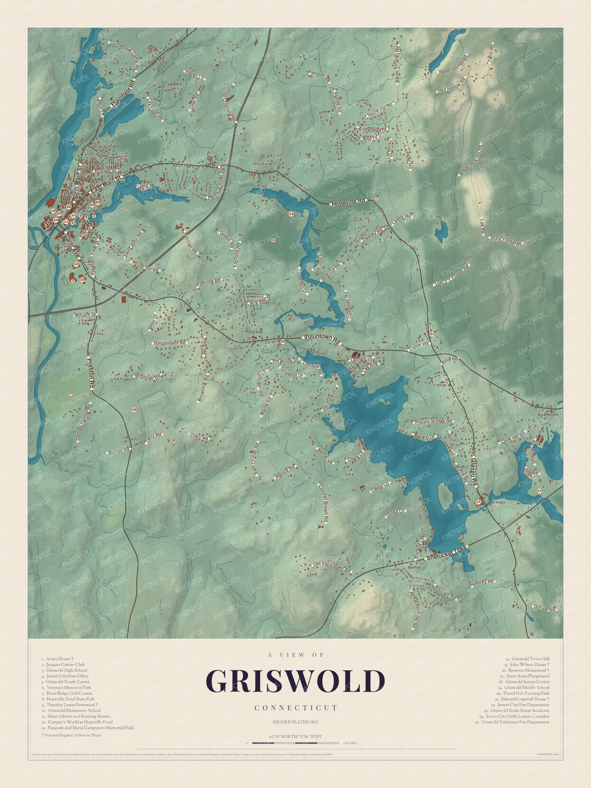
Click to explore a larger preview. The digital watermark does not appear on printed maps.
Names on this map
These names are printed on this map.
Places: Clayville, Voluntown, Avery House, Brewster Homestead, Camper's World at Hopeville Pond, David Hale Fanning Park, Griswold Elementary School, Griswold High School, Griswold Middle School, Griswold Senior Center, Griswold Soule Street Academy, Griswold Town Hall, Griswold Volunteer Fire Department, Hopeville Pond State Park, Jewett City Post Office, Mill Brook, Pasquale and Maria Camputaro Memorial Field, River Ridge Golf Course, Saint Anne Playground, Slater Library and Fanning Annex and Veterans Memorial Park.
Streets and roads: Russell St, E Main St, Plainfield Rd, Geer Rd, N Main St, Hollow Rd, Bow Ln, Lester Rd, Oakville Rd, William Dr, Bergendahl Rd, Brewster Rd.
More street names, A to Z
Bethel Rd, Bridge Rd, Burton Rd, Campbell Rd, Cedar Ln, Dutka Ln, Edmond Rd, Forest Rd, Gilliver Rd, Hill Ct, Patrick Rd, Popple Bridge Rd, Preston Rd, Rae Palmer Rd, Taylor Ln.
Jewett City
The cluster of numbers on the west side of the map is Jewett City. Griswold Town Hall (14), the Griswold Senior Center (18), the Griswold Soule Street Academy (23) and the Jewett City Post Office (4) stand close together there. The Slater Library and Fanning Annex (11), on Main Street, is the town’s public library. Its Romanesque Revival building of granite and brownstone went up in 1884 with money from the industrialist John Fox Slater, and the Fanning Annex nearly doubled its size in 1930, paid for by a bequest from the local businessman David Hale Fanning. It was listed on the National Register in 2002.
David Hale Fanning Park (20) carries his name, and Veterans Memorial Park (6), the Griswold Youth Center (5), the Jacques Cartier Club (2), the Jewett City Little League Complex (24) and the Jewett City Fire Department (22) are a few blocks east. Griswold High School (3), Griswold Middle School (19) and Griswold Elementary School (10) are just south of the borough.
The John Wilson House (15), on Ashland Street, was built about 1781 by John Wilson, who married Eliezer Jewett’s daughter. Wilson started a fulling mill in 1790 and in 1815 incorporated the Jewett City Cotton Manufacturing Company. The Georgian house is the only one left that’s tied to him or to Alfred Young, the agent of the Slater Mills, who moved it a short way in the 1860s. It was listed on the National Register in 1985.
Hopeville Pond
East of Jewett City is Hopeville Pond State Park (8), on Hopeville Pond, a pond made by damming the Pachaug River. The Mohegan built stone weirs in the river to catch fish. In 1711 Stephen Gates was granted land here and built a gristmill and a sawmill, and later John Slater built a mill he called the “Hope Mill,” which gave its name to the village, the pond and the park. By 1840 Hopeville was a thriving village known for its woolens. The Civilian Conservation Corps built the park in the 1930s, and it became a state park in 1938. Today its 554 acres offer swimming, fishing, trails and a campground with 80 sites. The guide also lists Camper’s World at Hopeville Pond (12).
The park manager lives in the Avery House (1), a central-chimney Colonial from about 1770 that the Civilian Conservation Corps fixed up for park use in 1935. Its fine paneling and original door frames survive, and it was listed on the National Register in 1986. In eastern Griswold, on Hopeville Road, is the Edward Cogswell House (21), whose oldest part dates to about 1740. It’s one of Griswold’s few 18th-century buildings, and Cogswell’s descendants kept it until 1862. The Griswold Volunteer Fire Department (25) is south of the pond.
The Southern Farms
On Preston Road in the west of town is the Brewster Homestead (16), built about 1740 and one of the oldest buildings in town. It stands on land that the Mohegan sachem Uncas gave to Jonathan Brewster, son of William Brewster of the Plymouth Colony. Simon Brewster began farming 250 acres here in 1740, and six generations of Brewsters owned the house until 1996. Part of the old farm is now a golf club across Preston Road, and River Ridge Golf Course (7) is nearby.
In southern Griswold, where Crary and Browning Roads meet, is the Timothy Lester Farmstead (9), also called the Garrison House. Its farmhouse was begun about 1741, the year Mehitable Belcher married Timothy Lester, and during the Revolution it served as a garrison and training ground. Stone walls still line its 43 acres, and it was listed on the National Register in 1998. In the southeast corner of town are the Pasquale and Maria Camputaro Memorial Field (13) and the Saint Anne Playground (17).
This map of Griswold makes a handsome addition to a living room, office, library or den, and it can even help teach children the geography and history of the town. It’s a thoughtful gift for anyone who calls Griswold home, grew up here, or moved away. Created by KNOWOL in 2026, it’s printed on museum quality archival paper in three sizes. Zoom in on the preview above to explore the details, then click here to get your copy of the Griswold map.

Sources