
A Cape Cod town of 1639 between Barnstable and the Bass River, where the old North Side runs along Route 6A through Yarmouth Port and South Yarmouth grew up as a Quaker village of salt works and sea captains.
Yarmouth on the map
Click the map to look closer.
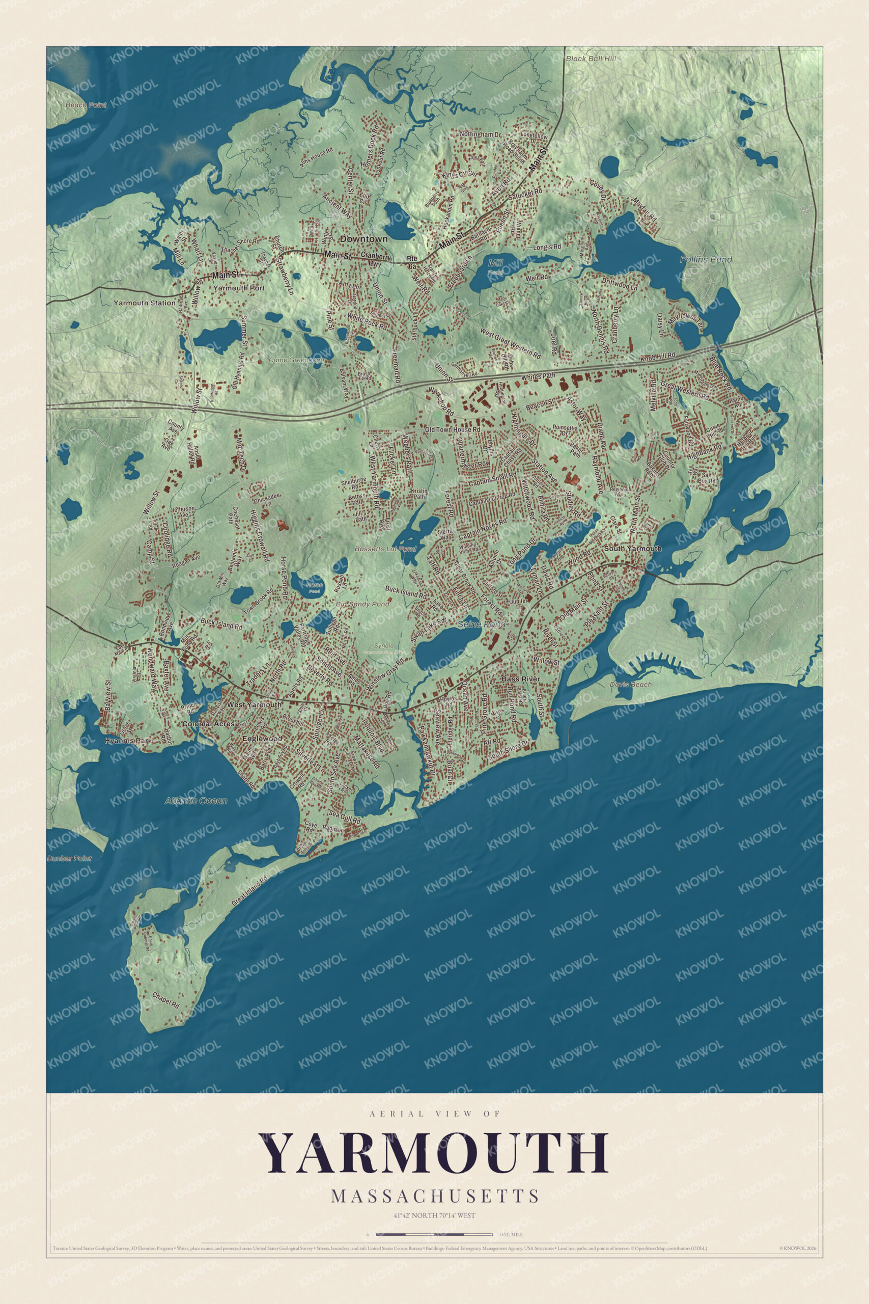
Yarmouth today
By KNOWOL
Every street from Yarmouth Port to Bass River, Englewood and Hyannis Park, with Follins Pond, Big Sandy Pond, Seine Pond, Bassetts Lot Pond, Black Ball Hill, Beach Point and Davis Beach printed on the map.5
The story of Yarmouth
The last wigwam by Long Pond
In 1713 Yarmouth's proprietors set aside a tract for the town's Native people to live on, plant and cut firewood, and an 1890 county history says that land was substantially today's village of South Yarmouth, close to the streams and shellfish beds they prized. Smallpox later swept the community, and in 1778 the town let the selectmen sell the land, keeping a tract for Thomas Greenough, one of the survivors. Nauhaught, the deacon of John Greenleaf Whittier's poem, lived on the south side of Long Pond, and the swamp across the road took the name Sarah's Swamp from his daughter. Asked near the end if he was resigned, he said he'd always had a pretty good notion of death. A monument of boulders on a hillside near Long Pond marks where the community's dead were laid to rest.6789
Salt, eels and scallops
Yarmouth people made their living from the water in more ways than one. As early as 1713 the town kept two acres of land and beach near Coy's Pond for its whalemen, forever. Then came the salt works. By 1865 the town had 19 of them, and an 1860 history adds that Epsom salts were made in quantity and a magnesia factory was running. Bass River gave a big supply of eels every winter, and by 1910 the scallop flats from Bass River to Lewis Bay covered about 2,250 acres. In South Yarmouth the boys treated the old salt works as a playground, sliding down them and playing robbers and pirates, and a 1915 writer wished at least a few of them had been saved.621011312
The mother town of the Mid-Cape
Yarmouth was incorporated in 1639, and together with Sandwich it's the oldest town on Cape Cod. A year before, the Plymouth court let Stephen Hopkins of the Mayflower build a house at Mattacheese to winter his cattle, and the house his son Giles lived in was long believed to be the first built below Sandwich. In 1644 Andrew Hallet gave a cow in calf for the town's poor, her calves to be passed along to other families in need. An 1898 guide called Yarmouth the town of clergymen, with a round dozen meetinghouses at one time. Dennis, part of Yarmouth for about a century and a half, asked to go and was set off in 1793. By 1890 Yarmouth Port, with its shaded main street, was called one of the most beautiful villages in the county.11314151617
Through the years
24 moments from 1638 to today.
- 1638The Plymouth court lets Stephen Hopkins build a house at Mattacheese, cut hay and winter his cattle there.13
- 1639Yarmouth is incorporated by Plymouth Colony on September 3.1
- 1639Richard Taylor settles the farm that's now the Taylor-Bray Farm.18
- 1644Andrew Hallet Sr. gives a cow in calf for the benefit of the town's poor.14
- 1648A court session with Miles Standish settles land disputes and fixes the Barnstable line nearly where it is now.19
- 1710About this year John and Shubel Baxter build their gristmill on Mill Pond.20
- 1713The proprietors keep two acres of land and beach near Coy's Pond for the town's whalemen, forever.6
- 1713A tract is set aside for the town's Native people, land that's substantially today's South Yarmouth.6
- 1776A town meeting declares Yarmouth's independence from Great Britain on June 20.1
- 1778After smallpox, the selectmen are allowed to sell the reserved land, keeping a tract for Thomas Greenough.7
- 1793Dennis, part of Yarmouth since the beginning, becomes its own town.1
- 1809The Friends Meeting House goes up in South Yarmouth.21
- 1817A temperance society is organized in Yarmouth, the second ever by an 1846 gazetteer's count.22
- 1854Capt. Asa Eldridge of Yarmouth sails the clipper Red Jacket from New York to Liverpool in a record 13 days.1
- 1860Yarmouth is producing Epsom salts in quantity and running a magnesia factory.10
- 1863Methodists buy the land for the Yarmouth Camp Ground near the depot.23
- 1865The town has 19 establishments making salt.2
- 1870The Gothic Revival library is built in Yarmouth Port.24
- 1890Weir Village's grinding mill on the north side has stood unused for fifty years.25
- 1896Lucy Taylor sells the family farm to the brothers George and William Bray.18
- 1910Yarmouth's scallop grounds on the south shore flats cover about 2,250 acres.3
- 1961The Baxter Mill is restored to working order.20
- 1970The Christmas Tree Shops chain is founded on Route 6A in Yarmouth Port.1
- 1987The town buys the Taylor-Bray Farm to keep it for preservation and conservation.18
Places to see
Places worth a visit in Yarmouth today.
- Yarmouth PortNorth side. The old village along Route 6A.
- Bass RiverDennis town line. Tidal river dividing Yarmouth from Dennis.
- Follins PondDennis town line. Wide pond on the Bass River.
- Big Sandy PondInland. One of the town's freshwater ponds.
- Bassetts Lot PondInland. One of the town's freshwater ponds.
- Old Town House RoadMiddle of town. A road across the middle of town.
- EnglewoodWest Yarmouth. Neighborhood on the south side.
- Hyannis ParkWest Yarmouth. Neighborhood by the Barnstable line.
On the National Register
All 6 places in Yarmouth on the National Register of Historic Places that still stand today, oldest first, and why each one matters.4
-
Taylor-Bray Farm
Richard Taylor settled this farm in 1639, and the Taylors kept it until 1896, when Lucy Taylor sold it to the brothers George and William Bray. The town bought it in 1987 to keep it as a farm for historic preservation and conservation.18
-
Northside Historic District
Almost 300 buildings in Yarmouth Port and Yarmouth Center, from the Colonel John Thacher House of about 1680 to Federal and Greek Revival houses of 1780 to 1860. It takes in the 1870 library and the First Congregational Church, whose congregation dates to the first meeting house of 1640.24
-
Baxter Mill
John and Shubel Baxter built this small gristmill on Mill Pond, and it's the only surviving 18th-century water-powered mill on Cape Cod. A turbine replaced its outside wheel in 1860, and it was restored to working order in 1961; the Yarmouth Historical Commission runs it as a museum.20
-
Thomas Bray Farm
Its house, estimated at about 1720 and possibly older, is one of the oldest in Yarmouth, an early half cape on about 10 acres beside Mill Pond. The 1920s outbuildings appear to have been built from the remains of an old barn.26
-
South Yarmouth/Bass River Historic District
The maritime village that grew up along the Bass River on land once set aside as a Native reservation, with houses from the 1790s on and the Friends Meeting House of 1809 with its burial ground. It later became a summer resort.21
-
Yarmouth Camp Ground Historic District
Methodists bought the core of this camp meeting ground in 1863, a mile from the Yarmouth depot, and held summer camps here until 1939. Small Gothic cottages replaced the first tents. The 1890 tabernacle was torn down in 1945 after hurricane damage, but the cottages remain.23
In their words
“In this town are a number of large and beautiful ponds, of pure and soft fresh water; such as would do the Boston folks good merely to look at.”
A gazetteer of Massachusetts, 184622
“As Barnstable was the town of lawyers, Yarmouth was preeminently the town of clergymen”
A trip around Cape Cod, 189815
“The latter is one of the most beautiful villages of the county.”
A gazetteer of the state of Massachusetts, 1890, on Yarmouthport17
Nearby towns
Sources
- Yarmouth, Massachusetts, Wikipedia
- Gazetteer of the state of Massachusetts (1874), Internet Archive
- A report upon the scallop fishery of Massachusetts (1910), Internet Archive
- National Register of Historic Places listings in Barnstable County, Massachusetts, Wikipedia
- Map of Yarmouth, Massachusetts in 2026, KNOWOL (USGS elevation, Census Bureau roads)
- History of Barnstable County, Massachusetts (1890), on the 1713 division of common lands, Internet Archive
- Library of Cape Cod history and genealogy (1910), on the history of South Yarmouth, Internet Archive
- Old Quaker Village, South Yarmouth, Massachusetts (1915), on Nauhaught, Internet Archive
- Old Quaker Village, South Yarmouth, Massachusetts (1915), on the burial ground near Long Pond, Internet Archive
- The history of Cape Cod: the annals of Barnstable County (1860), on Yarmouth's industries, Internet Archive
- The history of Cape Cod: the annals of Barnstable County (1860), on Bass River, Internet Archive
- Old Quaker Village, South Yarmouth, Massachusetts (1915), on the salt works, Internet Archive
- Library of Cape Cod history and genealogy (1910), on Giles Hopkins, Internet Archive
- Cape Cod, the right arm of Massachusetts (1897), on Andrew Hallet's gift to the poor, Internet Archive
- A trip around Cape Cod (1898), on Yarmouth's clergymen, Internet Archive
- A trip around Cape Cod (1898), on the separation of Dennis, Internet Archive
- A gazetteer of the state of Massachusetts (1890), Internet Archive
- Taylor-Bray Farm, Wikipedia
- Cape Cod, the right arm of Massachusetts (1897), on the Yarmouth boundaries, Internet Archive
- Baxter Mill, Wikipedia
- South Yarmouth/Bass River Historic District, Wikipedia
- A gazetteer of Massachusetts (1846), Internet Archive
- Yarmouth Camp Ground Historic District, Wikipedia
- Northside Historic District (Yarmouth, Massachusetts), Wikipedia
- History of Barnstable County, Massachusetts (1890), on Yarmouth's villages, Internet Archive
- Thomas Bray Farm, Wikipedia