
The Cape's largest town, a string of villages from Sandy Neck to Nantucket Sound, where Lothrop's people built their first meetinghouse in 1646, Marston's mill gave a village its name and Hyannis grew into the business center of Cape Cod.
Barnstable on the map
Click the map to look closer.
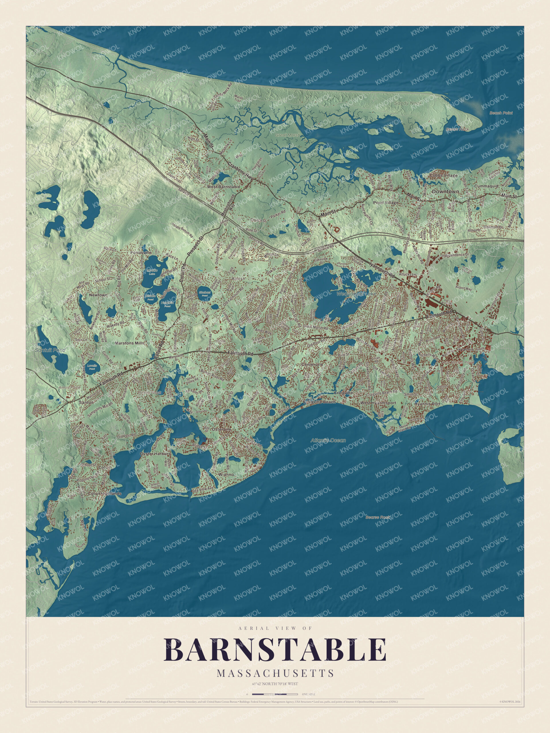
Barnstable today
By KNOWOL
Shaded relief from Cape Cod Bay to Nantucket Sound, with Wequaquet Lake, Santuit Pond, Aunt Bettys Pond, Baxter Neck and Beach Point, and Iyannough Road, Falmouth Road, Main Street and Cotuit Road.4
The story of Barnstable
Marston's mill and the herring run
The stream that runs from the ponds down to Cotuit harbor has been put to work for more than three hundred years. Thomas Macy built a fulling mill on it in 1689, when it was called the Goodspeed River. Benjamin Marston was running the mill by 1738, and the village has carried his name ever since. That same year the town ordered him to open a passage through his dam for the alewives, and in 1751 he was given a fourth of the herring taken at his brook for keeping it open. The fish mattered long before that: the 1658 agreement over the Cotuit lands left the alewives in the river free for Wampanoag and English alike. Up the road at Old Cotuit, Ezra Crocker's tavern was a favorite stop for Daniel Webster on his fishing trips.5678
Salt, schooners and Sandy Neck
For two centuries Barnstable lived off the water. Crocker Marchant built schooners and coasters at Hyannis Port very early, and soon after 1800 several families made salt on the plain toward Squaw Island. Near Barnstable Village the Crockers used a wind-driven salt mill to grind corn. In 1826 the government put a lighthouse on the point of Sandy Neck, and a writer in 1907 remembered when Barnstable had a great fishing fleet and was one of the busiest ports in the state. The harbor kept giving: in December 1884, 500 to 600 blackfish were driven ashore behind Sandy Neck. Over in Osterville, the Crosby yards on West Bay built boats known far and wide, and from 1914 nearly seventy Wianno knockabouts for the Wianno Yacht Club.9210111213
Lothrop's people
In May 1639 the Reverend Joseph Hull and Thomas Dimmock led the first settlers to Mattakeese and named the town for Barnstaple in Devon. That October the Reverend John Lothrop came from Scituate with families of his church, and in December a service of thanksgiving and a feast were held at Hull's house. The church's first meetinghouse went up in 1646 on Lothrop's Hill, a second in 1681, and the West Parish meetinghouse in 1717, which still stands. For centuries the church kept an old tankard it had carried over from England. Lothrop's own house of 1644 is part of the Sturgis Library now. James Otis Jr. was born at Great Marshes, in West Barnstable, in 1725, and at the town's 200th birthday a speaker repeated the saying that no spot had given the country a greater gift.141516171819
Through the years
25 moments from 1602 to today.
- 1602Bartholomew Gosnold becomes the first European to explore the area.1
- 1639In May the Reverend Joseph Hull and Thomas Dimmock lead the first settlers to Mattakeese.14
- 1639Barnstable is incorporated on September 4, the same day as Sandwich and Yarmouth.1
- 1639Thomas Lumbert is licensed to keep an inn and sell wine in the new town.10
- 1644A house is built for the Reverend John Lothrop. It's part of the Sturgis Library today.17
- 1646The first meetinghouse goes up on Lothrop's Hill.15
- 1658An agreement over the Cotuit lands leaves the river's alewives free for all to take.7
- 1685The court orders a road laid out through town. It becomes Barnstable Village's Main Street.20
- 1689Thomas Macy builds a fulling mill on the Goodspeed River, at what's now Marstons Mills.5
- 1690About this year the county's wooden jail is built in Barnstable Village.21
- 1717The West Parish meetinghouse is built in West Barnstable.15
- 1725James Otis Jr. is born in West Barnstable.18
- 1738Benjamin Marston runs the mill, and the town orders him to open his dam to the alewives.6
- 1800Soon after this year, families make salt on the plain at Hyannis Port.9
- 1815The old stone fort on the Crocker farm in West Barnstable is taken down.22
- 1821A post office opens at Old Cotuit, on the stage road to Hyannis.8
- 1826A lighthouse is built on the point of Sandy Neck.2
- 1831The granite county courthouse designed by Alexander Parris is built.23
- 1854The railroad reaches Barnstable.1
- 1855The brick Customshouse goes up on Cobbs Hill.24
- 1884In December, 500 to 600 blackfish are driven ashore behind Sandy Neck.11
- 1909Three thousand plover rise in one flock from Phyllis Island in Barnstable Harbor.25
- 1914The Crosby yard in Osterville starts building Wianno knockabouts for the Wianno Yacht Club.13
- 1920Cape Cod Hospital is established at Hyannis.26
- 1928Joseph P. Kennedy buys the Hyannis Port cottage that becomes the Kennedy Compound.27
Places to see
Places worth a visit in Barnstable today.
- Kennedy CompoundHyannis Port. The Kennedy family's summer home.
- Statue of IyannoughHyannis village green. The sachem the Pilgrims remembered as gentle.
- Sturgis LibraryBarnstable Village. Lothrop's house of 1644, now a library.Visit their website
- Hull's preaching rockAlong the old highway. Where the town's founder preached.
- Sandy NeckNorth shore. Long dunes sheltering Barnstable Harbor.Visit their website
- Wequaquet LakeNorthwest of Hyannis. 654 acres, also called Nine Mile Pond.
- Centerville Historic DistrictCenterville. The old village along Main Street.
- Centerville Historical MuseumCenterville. The village's own history museum.Visit their website
- Sampson's FollyCotuit. So grand it had an upstairs ballroom.
- Cotuit Historic DistrictCotuit. A seafaring village between two harbors.
On the National Register
20 of the 84 places in Barnstable on the National Register of Historic Places that still stand today, oldest first, and why each one matters. See the full list of National Register places in Barnstable.3
-
Goodspeed House
It is believed to have been built by Roger Goodspeed, Marstons Mills' first settler. The house was listed on the National Register of Historic Places in 1987.28
-
William and Jane Phinney House
Built c. 1659 later enlarged to a 3/4 cape in 1715, it is the oldest surviving house in the village, and has an early surviving example of a bowed roof, a distinctive regional variation on the Cape style house. The house was listed on the National Register of Historic Places in 1987.29
-
Jenkins-Whelden Farmstead
It is one of Barnstable's best-preserved farm properties. The farm complex includes a c. 1840 house, an older 18th century house that is used as a toolshed, two barns, and several other small outbuildings.30
-
Centerville Historic District
The heart of Centerville along Main Street, with about 40 buildings, most from the middle 1800s and the oldest, the Austin Bearse House, from about 1690. The village grew after the Congregational church was moved here in 1826.31
-
Old Jail
Built about 1690 by order of the colony courts, it's called the oldest wooden jail in the United States. It served as the county jail until about 1820, was found attached to a barn in 1968, and now stands on the grounds of the old Customshouse.21
-
Old King's Highway Historic District
Barnstable's whole length of Route 6A, the old main road from the Sandwich line to the Yarmouth line. It holds many Federal and Greek Revival houses, and Barnstable Village along it is still the county seat, with the courthouse of 1831.32
-
West Barnstable Village-Meetinghouse Way Historic District
The historic heart of West Barnstable, along Meetinghouse Way from County Road to the West Parish Meetinghouse of 1717, the district's best-known building, which the parish remodeled in the 1850s rather than tear down.16
-
Gideon Hawley House
A Georgian house built about 1758 by the missionary Gideon Hawley, who served the Mashpee Wampanoag nearby and lived here until his death in 1807. It was moved back from the road when Route 28 was widened in 1920.33
-
Ancient Burying Ground
Also called the Phinney's Lane Cemetery, it's the oldest cemetery in Centerville and the only surviving civic piece of the village's colonial past. The oldest marked grave, Jonathan Hamblen's, dates from 1743.34
-
Sampson's Folly-Josiah Sampson House
Built in 1807, it is the finest Federal style house in Cotuit and one of the finest in all of Barnstable. The Sampsons, intermarried with the locally prominent Crockers, were major landowners in the area.35
-
Barnstable County Courthouse
The two-story Greek Revival building was built in 1831 to a design by architect Alexander Parris. It is built mostly out of Quincy granite, although its front portico and fluted Doric columns are made of wood fashioned to look like stone.23
-
U.S. Customshouse
A brick Italianate customs house and post office designed by Ammi Young and built in 1855, when Barnstable was one of the busiest ports in Massachusetts. It's been a museum since 1960, now the Coast Guard Heritage Museum.24
-
Wianno Club
The club began as the Cotocheset House, a Shingle-style structure built in 1882 on the site of a grander hotel that burned down in 1881. This hotel was the centerpiece of a major resort development for the wealthy that was mostly developed prior to World War I. In 1916 the newly founded club purchased the hotel property.36
-
Marstons Mills Hearse House and Cemetery
The hearse house, essentially a garage, was built c. 1885 to house a hearse for the village of Marstons Mills, and was one of seven such buildings erected in Barnstable. It is one of only two that are now left, and the only one that is relatively unaltered and in its original setting.37
-
Craigville Historic District
A religious camp meeting founded in 1871 by the New England Convention of Christian Churches on Strawberry Hill, near Lake Elizabeth. Gothic cottages filled its streets, the open-walled tabernacle was built in 1887, and the camp was renamed Craigville in 1881.38
-
Witch (catboat)
A racing catboat designed and built by Bowdoin B. Crowninshield in 1900, later sailed around Osterville and renamed Wren and then Gypsy. She was given to the Osterville Historical Museum in 2008 and is shown there in summer.39
-
Kennedy Compound
National Historic Landmark
Three houses on six waterfront acres in Hyannis Port, the family home of Joseph P. and Rose Kennedy and their nine children. Joseph Kennedy bought the 1904 Malcolm Cottage here in 1928, and John F. Kennedy used the compound as the base of his 1960 campaign and as a Summer White House.27
-
Cotuit Historic District
The center of Cotuit along Main Street and Ocean View Avenue, about 125 properties mostly from 1850 to 1920, when the village was a seafaring port and then a summer resort. The oldest include the Samuel Dottridge House of about 1790, now a historical society museum.40
-
Hyannis Port Historic District
The Hyannis Port Historic District encompasses the historic heart of Hyannis Port, Massachusetts, an area that was intensively developed as a summer resort community beginning in the later decades of the 19th century. The district is about 100 acres (40 ha) in size, and extends from nearly Scudder Avenue in the west to Ocean Avenue in the east.41
-
Sandy Neck Cultural Resources District
Sandy Neck is a long spit of land extending east, west on the northern shore of the lower portion of Cape Cod, sheltering Barnstable Harbor. This area has a fairly lengthy history of human occupation, including archaeological prehistoric and colonial historic resources.42
In their words
“no spot in the country has made such a gift to the country, as the spot called Great Marshes, in Barnstable”
A discourse at Barnstable's 200th anniversary, 1839, on James Otis19
“when Barnstable had her great fishing fleet and coasting trade, and was one of the busiest ports of the Commonwealth”
In Olde Massachusetts, 190710
“The landscape at Cotuit deserves a whole book for itself.”
A trip around Cape Cod, 189843
Nearby towns
Sources
- Barnstable, Massachusetts, Wikipedia
- History of Barnstable County, Massachusetts (1890), on Barnstable Village and Sandy Neck Light, Internet Archive
- National Register of Historic Places listings in Barnstable, Massachusetts, Wikipedia
- Map of Barnstable, Massachusetts in 2026, KNOWOL (USGS elevation, Census Bureau roads)
- History of Barnstable County, Massachusetts (1890), on Marstons Mills, Internet Archive
- History of Barnstable County, Massachusetts (1890), on Marston's mill dam and the alewives, Internet Archive
- The history of Cape Cod: the annals of Barnstable County (1860), on the 1658 Cotuit agreement, Internet Archive
- History of Barnstable County, Massachusetts (1890), on Old Cotuit, Internet Archive
- History of Barnstable County, Massachusetts (1890), on Hyannis Port, Internet Archive
- In Olde Massachusetts: Sketches of Old Times and Places (1907), on Barnstable's old tavern, Internet Archive
- Cape Cod, the right arm of Massachusetts (1897), on the blackfish chase of 1884, Internet Archive
- History of Plymouth, Norfolk and Barnstable counties, Massachusetts (1928), on the Crosby boatyards, Internet Archive
- History of Plymouth, Norfolk and Barnstable counties, Massachusetts (1928), on Horace Manley Crosby, Internet Archive
- Joseph Hull, Wikipedia
- Articles of Faith and Covenant of the Congregational Church of West Barnstable (1917), Internet Archive
- West Barnstable Village-Meetinghouse Way Historic District, Wikipedia
- Sturgis Library, Wikipedia
- James Otis Jr., Wikipedia
- A discourse pronounced at Barnstable on the third of September, 1839 (1840), Internet Archive
- History of Barnstable County, Massachusetts (1890), on the county road, Internet Archive
- Old Jail, Wikipedia
- The Hamlin family: a genealogy of James Hamlin of Barnstable (1902), on William Crocker's stone fort, Internet Archive
- Barnstable County Courthouse, Wikipedia
- U.S. Customshouse, Wikipedia
- A history of the game birds, wild-fowl and shore birds of Massachusetts (1912), on the 1909 plover flight at Sandy Neck, Internet Archive
- History of Plymouth, Norfolk and Barnstable counties, Massachusetts (1928), on the town of Barnstable, Internet Archive
- Kennedy Compound, Wikipedia
- Goodspeed House, Wikipedia
- William and Jane Phinney House, Wikipedia
- Jenkins-Whelden Farmstead, Wikipedia
- Centerville Historic District, Wikipedia
- Old King's Highway Historic District, Wikipedia
- Gideon Hawley House, Wikipedia
- Ancient Burying Ground, Wikipedia
- Sampson's Folly-Josiah Sampson House, Wikipedia
- Wianno Club, Wikipedia
- Marstons Mills Hearse House and Cemetery, Wikipedia
- Craigville Historic District, Wikipedia
- ''Witch'' (catboat), Wikipedia
- Cotuit Historic District, Wikipedia
- Hyannis Port Historic District, Wikipedia
- Sandy Neck Cultural Resources District, Wikipedia
- A trip around Cape Cod (1898), on Centreville, Osterville and Cotuit, Internet Archive