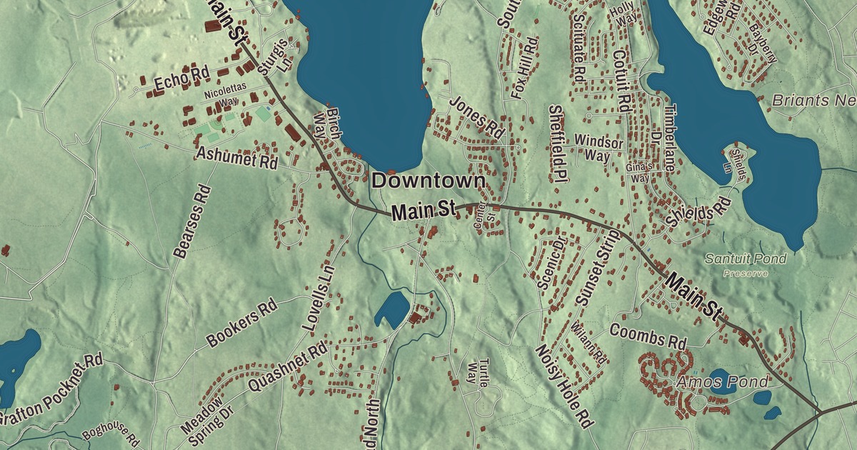
Mashpee is the historic and present-day home of the Mashpee Wampanoag Tribe, a Cape Cod town of ponds, pine woods and salt bays on Nantucket Sound. This map prints Main Street, Falmouth Road, Nathan Ellis Highway, Rock Landing Road, Wading Place Road and Shore Drive, with Mashpee Pond, Wakeby Pond, Ashumet Pond, South Cape Beach and Popponesset Beach. Click here to purchase a print of this map for your wall.
Mashpee is in Barnstable County.
KNOWOL made this map in 2026 from public survey data and gave it the look of an old atlas. The relief comes from United States Geological Survey elevation data, and the streets and the town line come from the Census Bureau. Mashpee covers 27.2 square miles on the upper, western part of the Cape, 23.4 of them land, bordered by Sandwich to the north, Barnstable to the east, Falmouth to the west and Nantucket Sound to the south. Waquoit Bay frames the shore on the west and Popponesset Bay on the east, and Boston is about 65 miles away. The town had 15,060 people at the 2020 census.
The Mashpee Wampanoag
People have lived on Cape Cod for more than ten thousand years, and the Wampanoag were the Native people the English met here. The town’s name, Mâseepee in Wampanoag, comes from words for “great” and “water,” translated as “the greater cove” or “great pond,” and the water it means is Wakeby Pond. The missionary Richard Bourne started a church here in 1658. The Town of Mashpee’s recorded history, in the Secretary of the Commonwealth’s list, dates European settlement to 1660, the year the colonists set aside about 50 square miles for the Wampanoag who had become Christians. From 1665 the Wampanoag ran their own court of law. In 1763 the Crown made Mashpee a plantation against the people’s will, and in 1788 the state took away their self-government and put them under a committee of five European-American overseers.
The Mashpee answered peacefully. In 1833 and 1834, led in part by William Apess, a Pequot Methodist minister and writer whom the tribe later adopted, they staged the Mashpee Woodland Revolt, protesting the state’s control of their government and settlers taking wood from their land, and a delegation traveled to Boston to seek justice. The state gave back a measure of self-government. The Old Indian Meeting House on Meetinghouse Road, built in 1758, was the site of the revolt in 1833, and its page calls it the oldest Native American church in the eastern United States. The tribe celebrated its restoration and reopening in 2009. Mashpee was incorporated as a town on May 28, 1870, and the town remains part of Barnstable County today.
A people and a language
In the early 1970s the Mashpee reorganized, and in 2007 the tribe won federal recognition. It’s one of two federally recognized Wampanoag tribes in Massachusetts, with its own health services, police force, court system and education departments, and its headquarters in Mashpee. The Wampanoag hold a pow-wow every year, with modern and traditional activities and crafts. Jessie Little Doe Baird, a linguist who lives in Mashpee, co-founded the Wôpanâak Language Reclamation Project to bring back the Wampanoag language, which helped the tribe start a language immersion school. More than 500 people have taken her classes, from preschoolers up, and she received a MacArthur Fellowship in 2010.
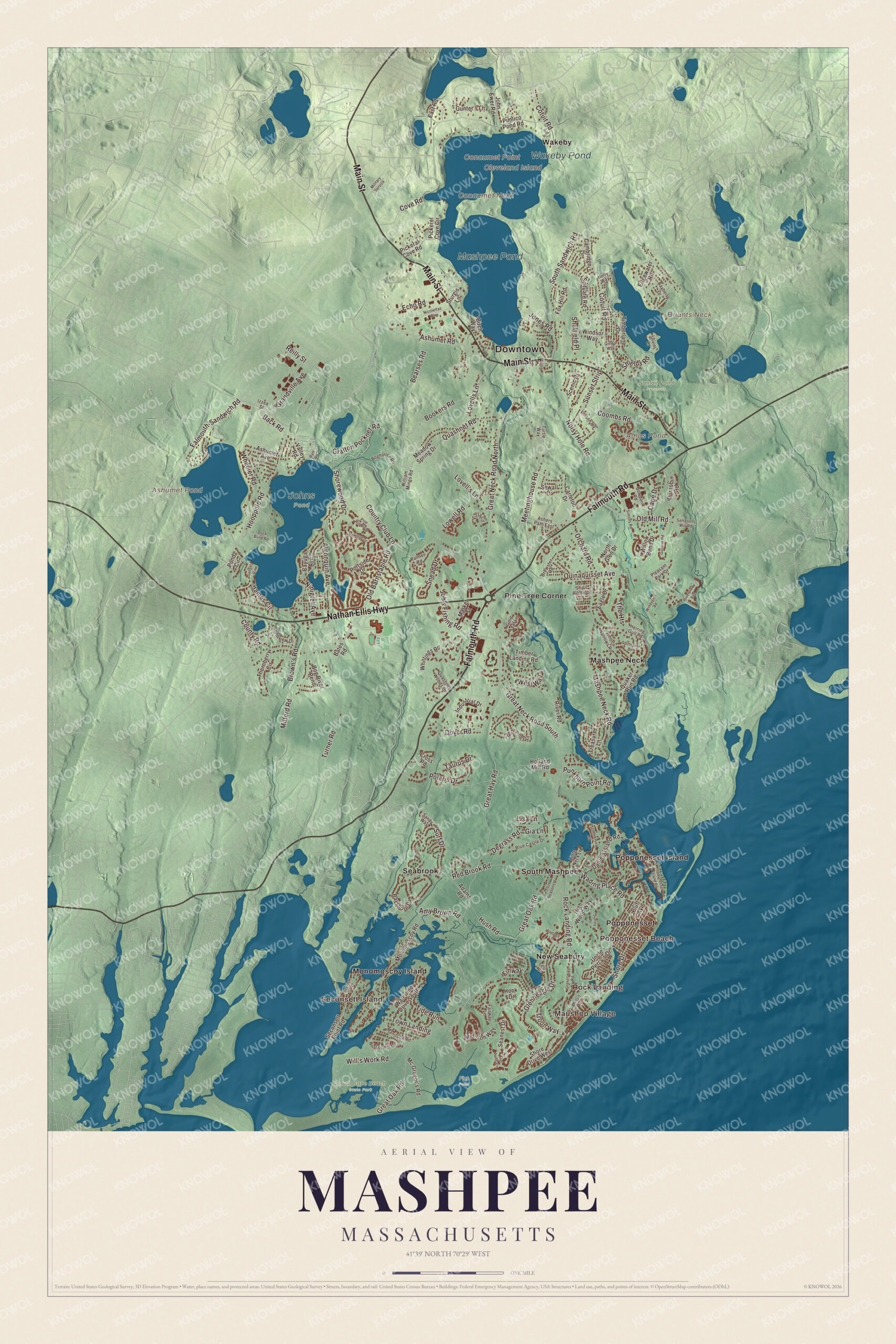
Click to explore a larger preview. The digital watermark does not appear on printed maps.
Names on this map
These names are printed on this map.
Places: Downtown, Maushop Village, Rock Landing, Seconsett Island, Popponesset Beach, Briants Neck, Cleveland Island, Conaumet Neck, Conaumet Point, Amos Pond, Ashumet Pond, Mashpee Pond, Wakeby Pond, Flat Pond, Johns Pond, Santuit Pond Preserve, South Cape Beach State Park, Mashpee Neck, Monomoscoy Island, New Seabury, Pine Tree Corner, Popponesset, Popponesset Island, Seabrook, South Mashpee and Wakeby.
Streets and roads: Main Street, Falmouth Road, Nathan Ellis Highway, Rock Landing Road, Wading Place Road, Shore Drive, Troon Way, Town Landing, Great Hay Road, Old Barnstable Road, Great Oak Road, Great Neck Road South.
More street names, A to Z
Adams Road, Algonquin Avenue, Amy Brown Road, Ashers Path East, Ashumet Avenue, Ashumet Road, Back Road, Bates Road, Bayberry Drive, Bayshore Drive, Bayview Road, Bearses Road, Birch Way, Blue Castle Drive, Bluff Avenue, Boghouse Road, Bog River Bend, Bonwood Drive, Bookers Road, Bowdoin Road, Brewster Road, Brown's Road, Cambridge Drive, Cape Drive, Carleton Drive, Cayuga Avenue, Center Street, Coombs Road, Cottage Lane, Cotuit Road, Country Club Lane, County Road, Cove Road, Cross Road, Daniels Island Road, Degrass Road, Dover Road, Duck Blind Road, Dunrobin Road, Eagle Drive, East Road, Echo Road, Edgewater Road, Fairway Lane, Falmouth-Sandwich Road, Fells Circle, Finway, Flat Pond Circle, Four Seasons Drive, Fox Hill Road, Gia Lane, Gina's Way, Glenneagle Drive, Gold Leaf Lane, Grafton Pocknet Road, Grandville Avenue, Great Neck Road North, Great Pines Drive, Greensward Road, Gullane Road, Gunter's Lane, Herring Gull Road, High Wood Way, Holland Mill Road, Holly Way, Hook Drive, Hooppole Road, Hush Road, Industrial Drive, Izzea Street, James Circle, Job's Fishing Road, John Ewer Road, Jones Road, Lisa Lane, Little Neck Lane, Lovell's Lane, Lovells Lane, Lowell Road, Manitoba Road, Market Street, Mashpee Neck Road, Mc Gregor's Road, Meadow Spring Drive, Meetinghouse Road, Mid-Iron Way, Milford Road, Military Service, Monomoscoy Road, Nicolettas Way, Ninigret Avenue, Noisy Hole Road, North Glen Drive, Old Mill Road, Orchard Road, Palmer Road, Pickeral Cove Road, Pickerel Cove Circle, Pimlico Pond Road, Pine Hill Boulevard, Pleasant Park Drive, Polaris Drive, Pond Circle, Pondview Drive, Popponesset Island Road, Portside Drive, Punkhorn Point Road, Quaker Run Road, Quashnet Road, Quashnet Woods Drive, Quinaquisset Avenue, Raft Road, Red Brook Road, Reilly Street, River Road, Riverview Avenue, Sampsons Mill Road, Sandy Way, Scenic Drive, Scituate Road, Seanest Drive, Seconsett Point Road, Sewall Drive, Sheffield Place, Shields Lane, Shields Road, Ship's Rudder Drive, Shore Drive West, Shorewood Drive, Simons Narrows Road, Simons Road, Snead Drive, South Sandwich Road, Spinnaker Drive, Sturgis Lane, Summersea Road, Sunset Circle, Sunset Strip, Surf Drive, Surrey Place, Taurus Drive, The Heights, Thornberry Circle, Tide Run, Timber Landing Road, Timberlane Drive, Treasure Lane, Turner Road, Turtle Way, Uncle Percy's Drive, Valley Road, Vista Circle, Waterline Drive South, West Way, Wharf Avenue, Wheeler Road, Whippoorwill Circle, Whittings Road, Wilann Road, Will's Work Road, William Mingo Road, Willow Bend Drive, Windsor Way, Windygate Road.
See it on a wall
The Mashpee map as a framed print. Swipe for more.


Around the map
Start with Maushop Village, then follow Main Street, Falmouth Road, Nathan Ellis Highway, Rock Landing Road, Wading Place Road and Shore Drive across town. Mashpee Commons, at the rotary where Routes 28 and 151 meet, opened in 1986 and is considered an early example of New Urbanism. The town page says Mashpee is the only town on Cape Cod that never had a railroad built to it. Then look outward toward Rock Landing, Seconsett Island, Popponesset Beach, Mashpee Neck and Monomoscoy Island. Amos Pond, Ashumet Pond, Mashpee Pond, Wakeby Pond, South Cape Beach, Briants Neck and Cleveland Island are all printed on the map, and every one of those names is right there on the artwork. Taken together, Mashpee and Wakeby ponds cover 729 acres and form the largest freshwater pond on Cape Cod, and the Lowell Holly Reservation, planted with holly, rhododendron and mountain laurel, reaches into both. Cleveland Island, in Wakeby Pond, once belonged to President Grover Cleveland. South Cape Beach State Park, part of the Waquoit Bay National Estuarine Research Reserve, has a mile of white sand beach, and Seconsett Island and Monomoscoy Island are each joined to the mainland, and neither is technically a true island.
The Mashpee map makes a fine addition to an office, library or den, and it can help teach children the geography and history of a Wampanoag homeland on Cape Cod. It’s made for people who call Mashpee home, from Mashpee Neck to Popponesset Beach, and it shows the town as it looks today. Zoom in on the preview above to explore the details, then click here to get your copy of the Mashpee, Massachusetts map.

Sources
- Mashpee, Massachusetts, Wikipedia
- Mashpee Wampanoag Tribe, Wikipedia
- Mashpee Woodland Revolt, Wikipedia
- William Apess, Wikipedia
- Old Indian Meeting House, Wikipedia
- Jessie Little Doe Baird, Wikipedia
- Mashpee and Wakeby Ponds, Wikipedia
- Lowell Holly Reservation, Wikipedia
- Cleveland Island (Massachusetts), Wikipedia
- South Cape Beach State Park, Wikipedia
- Mashpee Commons, Wikipedia
- Seconsett Island, Massachusetts, Wikipedia
- Monomoscoy Island, Massachusetts, Wikipedia
- City and Town Incorporation and Settlement Dates, Secretary of the Commonwealth of Massachusetts (archived copy)