
A town of four villages on the Quinebaug and Moosup rivers, where an academy once drew students from three states, Rochambeau's army marched through, and stone and brick mills made cotton and fine woolens for more than a century.
Then and now
The same town 137 years apart. Click either map to look closer.
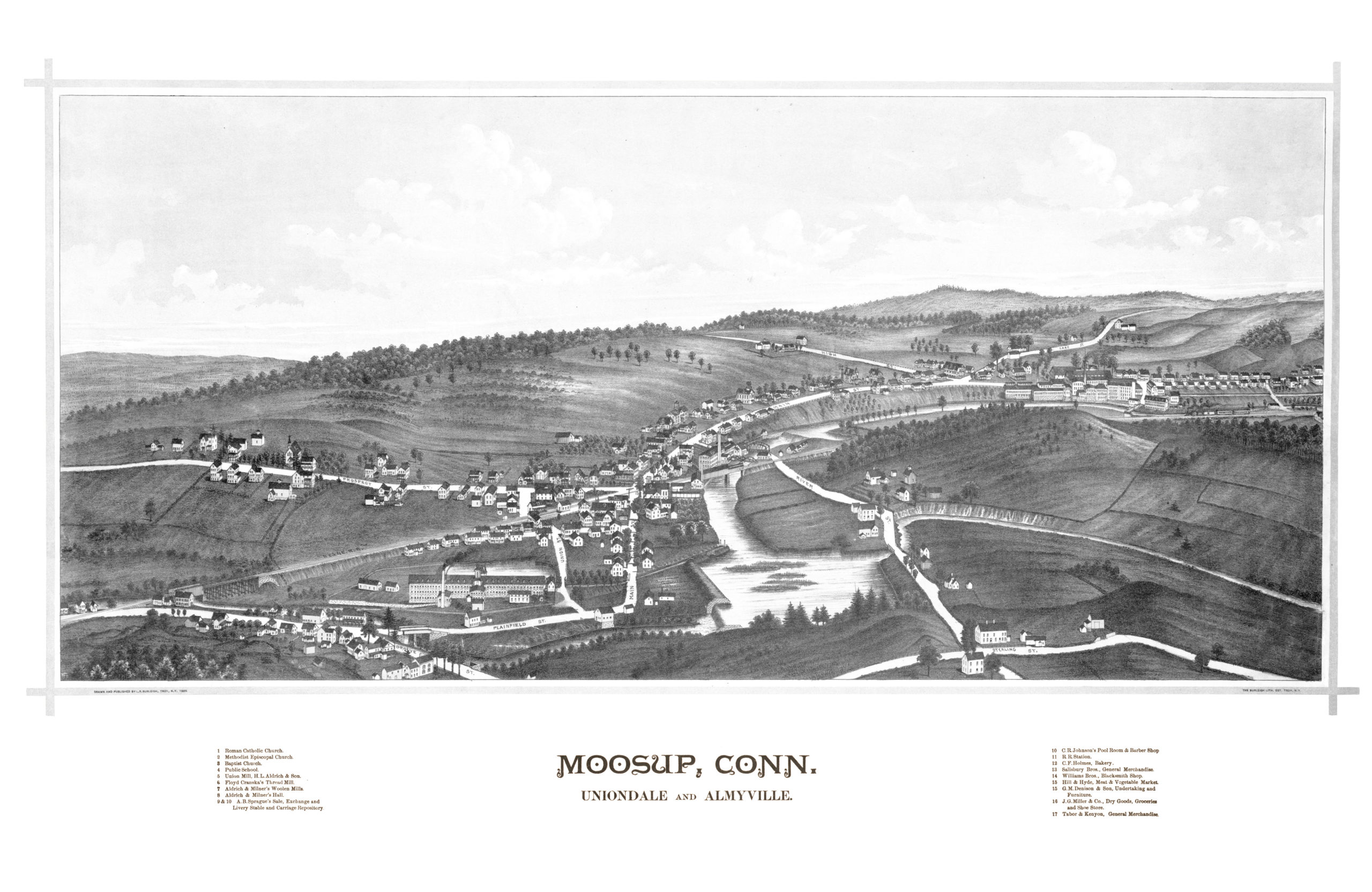
Moosup in 1889
By Lucien R. Burleigh
The village of Moosup as it looked in 1889, with the Union Mill, Aldrich and Milner's woolen mills, the railroad, the Hill and Hyde market and C.R. Johnson's pool room and barber shop.5
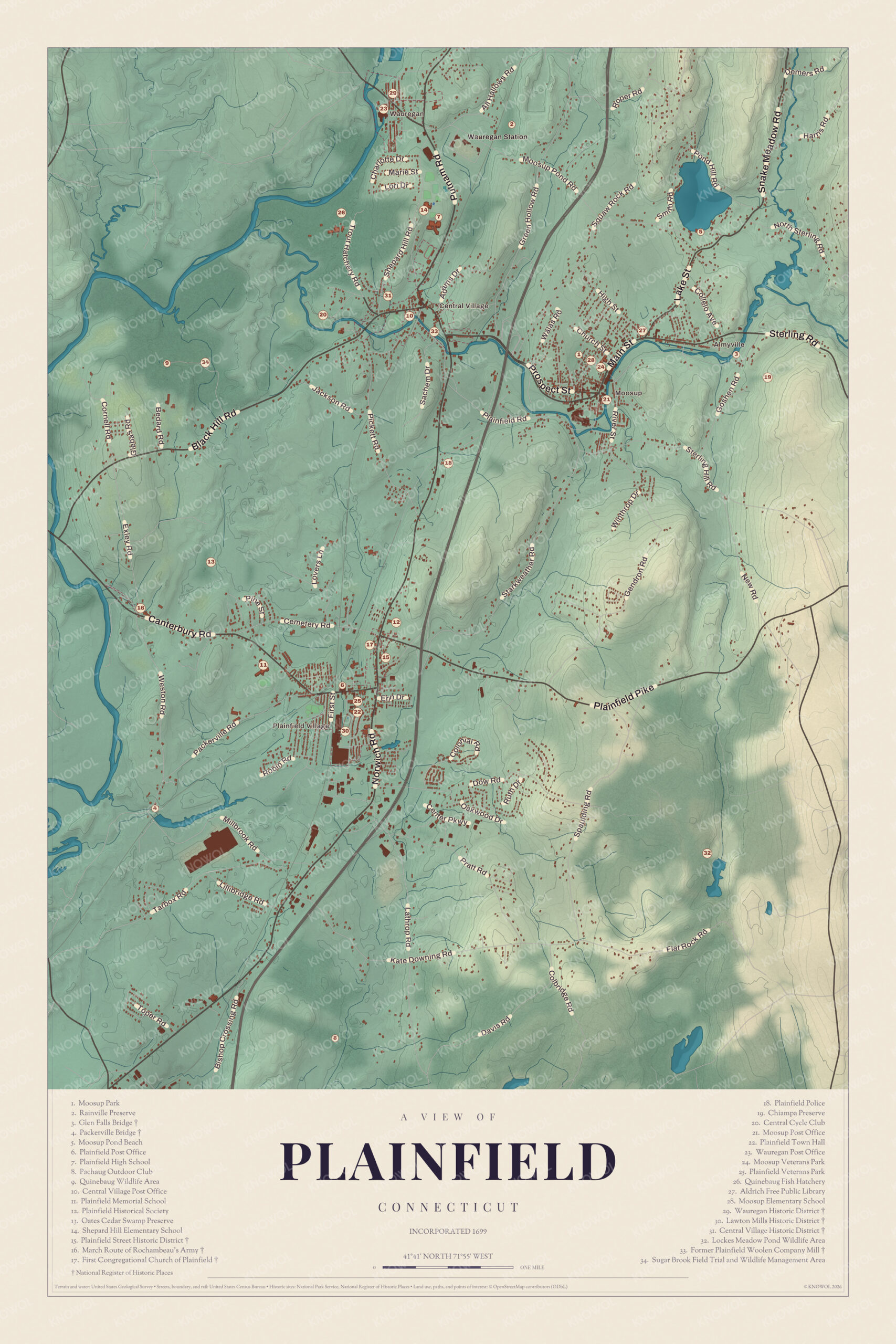
Plainfield today
By KNOWOL
Shaded land from the Quinebaug valley in the west to the Moosup River across the north, every street, the four villages and Moosup Pond, and a guide of 34 numbered landmarks with the National Register sites marked.6
The story of Plainfield
The night the Moosup ran wild
On the night of February 13, 1886, the Moosup River burst its banks in one of the worst freshets the town had ever seen. An eyewitness wrote that the river, usually so quiet, swept everything before it. At Central Village the Central bridge was simply gone, the houses on the flat were emptied, and the mill trench was torn out, putting people out of work. Just downstream an old bridge on loose-looking abutments somehow stayed up, with the road washed away on both sides, "a pigmy mocking at the strength of a giant." In Moosup most of the bridges went, and a tenement house was carried off so fast its tenants barely got out. The stone Packerville Bridge, built that same year after the flood, still stands.78
Schoolboys on the Providence road
In 1778 Plainfield's leading men hired Ebenezer Pemberton of Newport to teach Latin in their new brick schoolhouse. With colleges closed and seaports open to attack, families in Providence, New London and New York sent their sons to this safe inland village, and soon there were more than a hundred students from away. Townspeople took them in, and Dr. Elisha Perkins boarded scores of boys in his own house. Nathan Daboll, who wrote the arithmetic book The Schoolmaster's Assistant, taught mathematics. In June 1781, when Rochambeau's French army came up the Providence road, a hundred schoolboys in Plainfield village cheered it on. The doctor, meanwhile, had patented his metallic tractors, which made his name known as far away as London and Copenhagen.91011
Wauregan, the pleasant valley
Wauregan takes its name from a Mohegan word meaning pleasant valley. Amos D. Lockwood bought the water rights on the Quinebaug about 1850, and the Wauregan Mills were chartered in 1853. Over the next fifteen years the mill grew into three connected buildings of rough stone, quarried nearby, about 1,250 feet long in all. By 1889 it ran 56,000 spindles and 1,400 looms and turned out eight to nine million yards of cotton cloth a year. James S. Atwood set out to make it a model village, and an 1880 history agreed he had, with houses, store, hall, gardens and green all in keeping. The village library lent books to anyone for ten cents a week.12313
Through the years
25 moments from 1689 to today.
- 1689Settlers, most of them from Chelmsford, Massachusetts, begin farming the plains along the Quinebaug.14
- 1699The settlement is incorporated as the town of Quinebaug.1
- 1700The town takes the name Plainfield, for its fertile plains.1
- 1703The first meeting house, on the summit of Black Hill, is ready for use.15
- 1703The Quinebaug River is made the line between the east and west side settlers; the west side becomes Canterbury.16
- 1705Joseph Coit is ordained as the first pastor, and the church is organized with ten members.15
- 1714The colony road to Providence opens through the town.17
- 1728A toll cart bridge is built over the Quinebaug, twenty-seven feet above the riverbed.18
- 1767A freshet takes the Quinebaug bridge, and Widow Williams is rewarded for saving twenty planks.18
- 1775The town votes, with one voice against, to buy no East India tea.19
- 1778Ebenezer Pemberton of Newport becomes rector of the new classical school, Plainfield Academy.9
- 1781Rochambeau's French army camps at Plainfield on its march to Yorktown, cheered by a hundred schoolboys.10
- 1797Captain Ebenezer Eaton opens the post office at his stage tavern, the third in Windham County.2
- 1809The Plainfield Union Manufacturing Company starts spinning cotton on the Moosup.20
- 1811The Andrus Factory Company's small mill begins the village of Packerville.20
- 1815The September Gale wrecks the meeting house.21
- 1816The congregation builds its stone church to plans by Ithiel Town.22
- 1845The Central Manufacturing Company builds a brick mill at Central Village.23
- 1853The Wauregan Mills are chartered and the first stone mill goes up on the Quinebaug.3
- 1868The Robinson and Fowler foundry moves to Plainfield Junction to make stoves and furnace castings.24
- 1886On February 13 the Moosup River floods, carrying away most of the town's bridges.7
- 1889Lucien R. Burleigh's map of Moosup is published.5
- 1895The Aldrich Free Public Library opens its Queen Anne building in Moosup.25
- 1901The Plainfield Woolen Company builds its mill at Central Village.26
- 1905Harold Lawton starts the Lawton Mills on Horse Brook in Plainfield Village.27
Places to see
The numbers match the landmark guide printed on the 2026 map.
- 3Glen Falls BridgeEast edge of Moosup. Lenticular iron truss of 1886.
- 4Packerville BridgePackerville Road. Stone arch built after the 1886 flood.
- 15Plainfield Street Historic DistrictNorwich Road. The old crossroads village on the ridge.
- 16March Route of Rochambeau's ArmyPlainfield Pike. The French army's road of 1781.
- 17First Congregational Church of PlainfieldPlainfield Village. Ithiel Town's stone church of 1816.
- 27Aldrich Free Public LibraryMoosup. Queen Anne library of 1895.Visit their website
- 29Wauregan Historic DistrictWauregan. Atwood's model mill village on the Quinebaug.
- 30Lawton Mills Historic DistrictPlainfield Village. Brick mill and 125 workers' duplexes.
- 31Central Village Historic DistrictCentral Village. Mill village where Routes 12 and 14 meet.
- 33Former Plainfield Woolen Company MillCentral Village. The monitor-roofed mill of 1901.
On the National Register
All 12 places in Plainfield on the National Register of Historic Places that still stand today, oldest first, and why each one matters.4
-
March Route of Rochambeau's Army: Old Canterbury Road
A stretch of road, with stone walls and old sugar maples, that Rochambeau's army marched in June 1781 on its way to Virginia and again in November 1782 on its way back to Rhode Island.28
-
March Route of Rochambeau's Army: Plainfield Pike
A 3.6-mile stretch of Route 14A in Plainfield and Sterling, lined by stone walls, that the French army marched in 1781 and 1782. Its nomination calls it the longest continuous part of the route to survive with these features intact.29
-
Plainfield Street Historic District
The old town center on the ridge east of the Quinebaug, where the north-south road crossed the road from Hartford to Providence. Its 30 buildings date mostly from the late 1700s and early 1800s, among them Union Hall of about 1800.30
-
Sterling Hill Historic District
An early 1800s village center on Plainfield Pike, almost untouched by later building, where the French army camped in 1781 and 1782. Most of it is in Sterling; one house at its western edge is in Plainfield.31
-
Central Village Historic District
A mill village that grew from a small cotton mill of 1814 on the Moosup River, with a little commercial center, mill owners' houses, workers' housing, the old town hall of 1872 and the high school of 1924.23
-
First Congregational Church of Plainfield
Built after a gale destroyed the old meeting house, to plans by Ithiel Town of nearby Thompson. It is a rare Federal-period stone church in Connecticut, and it also held town meetings in the 1800s.22
-
Wauregan Historic District
James S. Atwood built Wauregan as a model mill village around an H-shaped mill of local fieldstone. It keeps the mill, Atwood's home, the company store, two boarding houses and over a hundred workers' houses.12
-
Glen Falls Bridge
A wrought iron lenticular truss 124 feet long, made by the Berlin Iron Bridge Company. When it was listed it was one of fifteen surviving lenticular truss bridges in the state. It is closed to traffic.32
-
Packerville Bridge
A stone arch built after a great flood washed away most of the town's bridges, made of stone because bridges below mill dams were at greater risk. It is one of fewer than twenty 19th-century stone arch bridges left in the state.8
-
Aldrich Free Public Library
A Queen Anne library with a rounded turret and its original oak bookcases, designed by Charles F. Wilcox of Providence. Mill owner David Aldrich left money for it and his partner Edwin Milner gave the land.25
-
Plainfield Woolen Company Mill
The mill that revived Central Village, making fine woolens for men's suits and coats with up to 300 workers. Its monitor roof makes it a landmark, and it made textiles until 1984. It is condominiums now.26
-
Lawton Mills Historic District
Harold Lawton's cotton mill of 1905 on Horse Brook, with 125 Colonial Revival duplexes he built for workers. It employed as many as 1,200 people before closing in 1936, and its community hall is now the town hall.27
In their words
“Old Plainfield Village has perhaps the finest avenue of trees in Windham County, and many handsome residences.”
History of Windham County, Connecticut, vol. 2, 188033
“A hundred eager school boys in Plainfield village gave them vociferous welcome.”
History of Windham County, Connecticut, 1889, on Rochambeau's army in June 178110
“The Moosup River, usually so quiet and peaceful, had yielded to the elements and soon was beyond control”
An eyewitness of the 1886 flood, in History of Windham County, Connecticut, 18897
Nearby towns
Sources
- Plainfield, Connecticut, Wikipedia
- History of Windham County, Connecticut (1889), on the post office of 1797, Internet Archive
- History of Windham County, Connecticut (1889), on the Wauregan Mills, Internet Archive
- National Register of Historic Places listings in Windham County, Connecticut, Wikipedia
- Map of Moosup, Connecticut from 1889, restored by KNOWOL
- Map of Plainfield, Connecticut in 2026, KNOWOL (USGS elevation, Census Bureau roads)
- History of Windham County, Connecticut (1889), on the freshet of 1886, Internet Archive
- Packerville Bridge, Wikipedia
- History of Windham County, Connecticut (1889), on Plainfield Academy, Internet Archive
- History of Windham County, Connecticut (1889), on Rochambeau's march, Internet Archive
- History of Windham County, Connecticut (1889), on Dr. Elisha Perkins, Internet Archive
- Wauregan, Connecticut, Wikipedia
- History of Windham County, Connecticut, vol. 2 (1880), on Wauregan, Internet Archive
- A gazetteer of the states of Connecticut and Rhode-Island (1819), Internet Archive
- History of Windham County, Connecticut (1889), on Plainfield's first years, Internet Archive
- The public records of the colony of Connecticut (1850), on the 1703 dividing line, Internet Archive
- History of Windham County, Connecticut (1889), on the road to Providence, Internet Archive
- History of Windham County, Connecticut (1889), on the Quinebaug bridges, Internet Archive
- History of Windham County, Connecticut (1889), on Plainfield in the Revolution, Internet Archive
- History of Windham County, Connecticut (1889), on the first cotton and woolen mills, Internet Archive
- History of Windham County, Connecticut (1889), on the September Gale, Internet Archive
- First Congregational Church of Plainfield, Wikipedia
- Central Village Historic District, Wikipedia
- History of Windham County, Connecticut (1889), on Kennedy City and Plainfield Junction, Internet Archive
- Aldrich Free Public Library, Wikipedia
- Plainfield Woolen Company Mill, Wikipedia
- Lawton Mills Historic District, Wikipedia
- March Route of Rochambeau's Army: Old Canterbury Road, Wikipedia
- March Route of Rochambeau's Army: Plainfield Pike, Wikipedia
- Plainfield Street Historic District, Wikipedia
- Sterling Hill Historic District (Plainfield and Sterling, Connecticut), Wikipedia
- Glen Falls Bridge, Wikipedia
- History of Windham County, Connecticut, vol. 2 (1880), on Plainfield's villages, Internet Archive