
The Nauset of the Pilgrims, a farming town on the forearm of Cape Cod where the first encounter took place in 1620, salt works once lined the bay, and the Three Sisters and Nauset Light still watch the Atlantic.
Eastham on the map
Click the map to look closer.
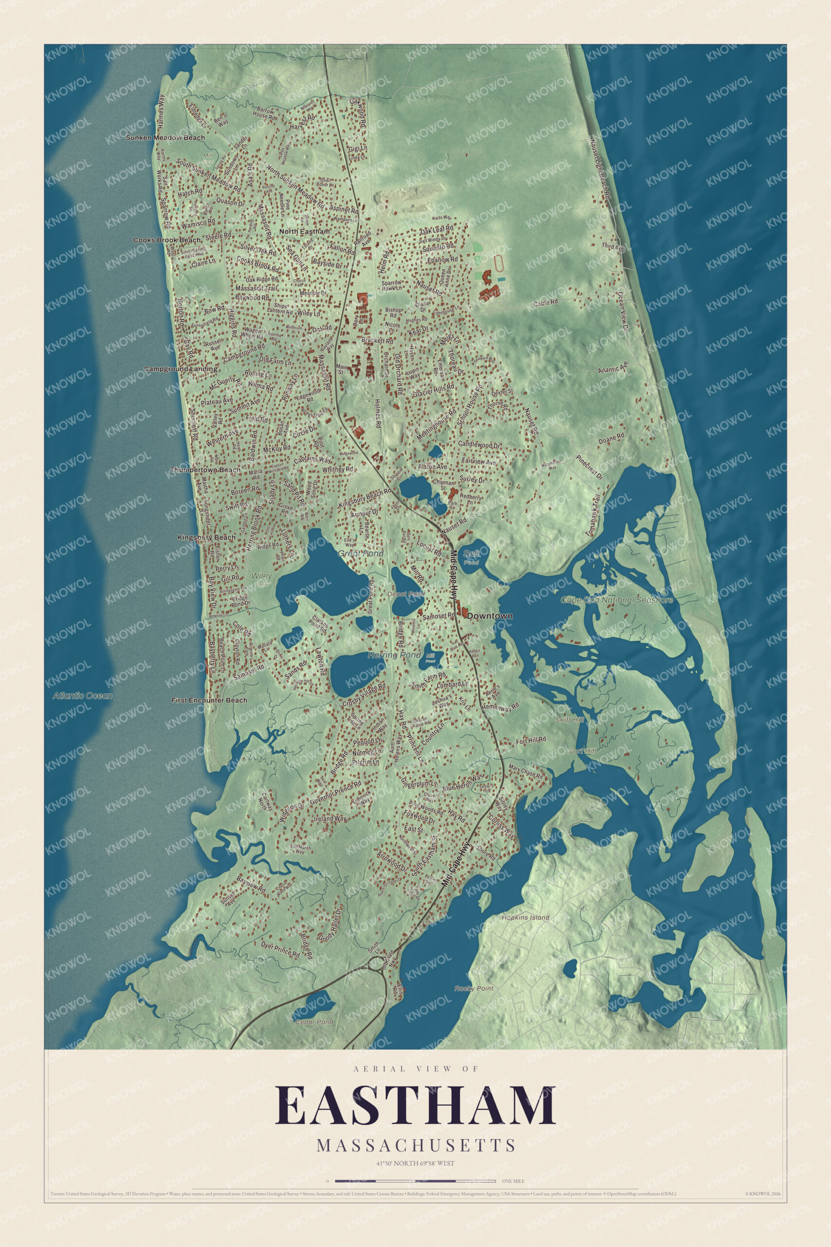
Eastham today
By KNOWOL
Eastham between Cape Cod Bay and the Atlantic, with the Mid-Cape Highway, Massasoit Road, Nauset Road and Ocean View Drive, and Fort Hill, Great Pond, Herring Pond, Hopkins Island and First Encounter Beach printed on the map.6
The story of Eastham
Whales, crows and the hour glass
Old Eastham ran its affairs its own way. In 1662 the town voted that part of every whale cast ashore should go to support the minister, and Thoreau later pictured the parsons sitting on the sand hills in storms, watching for their salaries to roll in over the bars. A sexton turned an hour glass when the sermon began, and the preaching was expected to end just as the sand ran out. Votes were cast with corn for yes and beans for no. When crows and blackbirds raided the corn fields, every unmarried man had to kill three crows and six blackbirds before he could marry. A 1928 county history passes that rule along from a magazine article and admits nobody knows how well it worked.78
Captain Mayo runs the pinkie ashore
During the War of 1812, British ships cut Eastham off from Boston, and people reached New York by creeping along the coast to Sandwich, carting their boats across to Buzzards Bay and trading dried fish for flour. Captains Matthew H. Mayo and Winslow E. Knowles were captured with a load of supplies. Knowles went to Boston to raise a ransom, and the British made Mayo pilot their vessel. He brought her to anchor off Billingsgate Point, weakened the hawser until it broke, and she went ashore just south of the old camp ground at North Eastham, within a mile of his own house. His neighbors captured the crew, who spent a night in George Collins' barn and were let go. Under threat of bombardment, the town paid the British twelve hundred dollars.49
Salt, clams and asparagus
Eastham's sandy fields and shallow bay kept people busy in ways that changed with each generation. Salt making took hold about 1799, and by 1837 there were fifty-four salt works along the bay and around Town Cove, making 22,370 bushels a year. That same year the fishermen brought in 4,550 barrels of mackerel. Later, digging, opening and salting clams for bait gave work to two hundred people. Once the bay ice ploughed up so many quahaugs that the leftovers were dumped into Salt Pond, where they multiplied until, as the 1890 county history puts it, they were actually fabulous. Then came asparagus, forty acres of it by 1890 and 3,500 boxes a year by 1928, with Cape turnips and cranberries besides.310
Through the years
25 moments from 1605 to today.
- 1605Samuel de Champlain describes the Nauset homes and corn fields around Nauset Harbor.11
- 1620A Mayflower party finds a dead grampus on the bay shore and thinks of calling the place Grampus Bay.12
- 1620The Pilgrims' first encounter with the Nauset takes place at what's now First Encounter Beach.1
- 1644Seven families from Plymouth, forty-nine people in all, begin the settlement at Nauset.4
- 1646The colony court makes Nauset a township.13
- 1651The court orders that Nauset be called Eastham from then on.13
- 1657Thomas Prence of Eastham is elected governor of Plymouth Colony and is allowed to keep living here.14
- 1662The town votes that part of every whale cast ashore will help pay the minister.7
- 1717Rev. Samuel Treat dies after forty-five years as Eastham's minister.15
- 1720The Bridge Road Cemetery is laid out by the town's second meetinghouse.16
- 1763The north precinct is set off as the district of Wellfleet.17
- 1793The windmill now in Windmill Park arrives in Eastham.18
- 1797The south part of the town becomes Orleans, leaving Eastham its present size.19
- 1798Eastham's post office opens on January 1.20
- 1816An epidemic kills seventy-two people in four months.4
- 1828The Methodists hold the first camp meeting at the grove later called Millennial Grove.3
- 1837Fifty-four salt works make 22,370 bushels of salt.3
- 1838A beacon of three lights goes up on the Atlantic cliffs, with Captain Michael Collins as prime mover.3
- 1851The town builds its first town hall.21
- 1868Captain Edward Penniman builds his house at Fort Hill.22
- 1870The first passenger train runs through on the last day of December.20
- 1879Governor Prence's ancient pear tree is said to have blown down.23
- 1890The Universalist church, backed by Captain Penniman, is dedicated in January.24
- 1923Nauset Light, an 1877 tower from Chatham, is moved to Eastham.25
- 1961The Cape Cod National Seashore is founded, taking in about a third of the town.1
Places to see
Places worth a visit in Eastham today.
- First Encounter BeachCape Cod Bay shore. Where the Pilgrims first met the Nauset.
- Eastham WindmillWindmill Park, Eastham Center. The oldest windmill on Cape Cod.
- Fort HillOff Route 6, near Town Cove. Fields and salt marsh views.Visit their website
- Penniman HouseFort Hill. A whaling captain's house of 1868.
- Skiff HillNorth of Fort Hill. A rise above Nauset Marsh.
- Nauset LightOcean View Drive and Cable Road. Red-topped tower moved from Chatham.Visit their website
- Three Sisters of NausetCable Road. Three small lights, together again.Visit their website
- Great PondCenter of town. The largest pond, with two beaches.
- Cooks Brook BeachNorth Eastham. Bay beach at the end of Steele Road.
- 1741 Swift-Daley HouseRoute 6. Eastham Historical Society museum.Visit their website
On the National Register
All 12 places in Eastham on the National Register of Historic Places that still stand today, oldest first, and why each one matters.5
-
Cove Burying Ground
Eastham's oldest cemetery, laid out about 1646 beside the first meetinghouse, and the only burying ground in town until 1720. Mayflower passengers Giles Hopkins, Constance Hopkins and Joseph Rogers have marked stones here.26
-
Old Town Center Historic District
Eastham's first town center near Salt Pond, with 42 contributing buildings, among them the John Knowles House of about 1672, the first town hall of 1851 and the schoolhouse of 1869.21
-
Bridge Road Cemetery
The town's second cemetery, laid out in 1720 at the site of the second meetinghouse. Most burials date from about 1770 to 1830, and the earliest dated stone is from 1754.16
-
Fort Hill Rural Historic District
About 100 acres of forest, fields and salt marsh held by the Knowles and Penniman families from 1742 to 1941, part of the Cape Cod National Seashore since 1961.27
-
Edward Penniman House and Barn
Edward Penniman went to sea on a whaler at eleven and commanded his own ship by 29. He drew the plans for this house himself, including a bath with hot running water.22
-
Eastham Center Historic District
The village that grew up around the railroad station of 1870, with the Town Hall of 1912, the library of 1897, the Universalist chapel and Windmill Park.28
-
Nauset Beach Light
An 1877 tower from Chatham, moved here in 1923 to replace the Three Sisters. Its top was painted red in the 1940s, and in 1996 it was moved back 336 feet from the eroding cliff.25
-
French Cable Hut
The small hut where the French Cable Company's transatlantic telegraph cable came ashore and joined the line to its station in Orleans. The National Park Service moved it back from the bluff and restored it in 1998 to 2000.29
-
The Beacon
The center one of the Three Sisters, the only one kept lit after 1911, flashing three times for herself and her two sisters.30
-
Three Sisters of Nauset (Twin Lights)
Wooden towers that replaced the three brick lights of 1838 after erosion. The National Park Service bought them back and set the three up together in their old line.30
-
Collins Cottages Historic District
Small summer cottages that Lewis and Bernard Collins built on Town Cove in 1928 and 1929, still run by the Collins family.31
-
Nauset Archeological District
National Historic Landmark
A National Historic Landmark where people lived around Nauset Harbor for at least 6,000 years. Champlain mapped the Nauset homes, gardens and fish weirs here in 1605.11
In their words
“The people are industrious and enterprising, and still retain the other good habits, which did honour to their fathers”
A description of Eastham, 1802, in the Collections of the Massachusetts Historical Society19
“Eastham was from the start, owing to its corn, a very great favorite with the Plymouth people”
A trip around Cape Cod, 189813
“Thrift appears in the neat surroundings of the cottages, and the two towering church spires in the distance”
History of Barnstable County, 189020
Nearby towns
Sources
- Eastham, Massachusetts, Wikipedia
- City and Town Incorporation and Settlement Dates, Secretary of the Commonwealth of Massachusetts
- History of Barnstable County, Massachusetts (1890), on Eastham's salt works, fishing, lights and camp ground, Internet Archive
- History of Barnstable County, Massachusetts (1890), on the town of Eastham, its land and the War of 1812, Internet Archive
- National Register of Historic Places listings in Barnstable County, Massachusetts, Wikipedia
- Map of Eastham, Massachusetts in 2026, KNOWOL (USGS elevation, Census Bureau roads)
- Historic towns of New England (1899), Internet Archive
- History of Plymouth, Norfolk and Barnstable counties, Massachusetts (1928), on old Eastham customs, Internet Archive
- The maritime history of Massachusetts, 1783-1860 (1921), Internet Archive
- History of Plymouth, Norfolk and Barnstable counties, Massachusetts (1928), on Eastham farming, Internet Archive
- Nauset Archeological District, Wikipedia
- The history of Cape Cod: the annals of Barnstable County (1860), on the Pilgrims at Eastham, Internet Archive
- A trip around Cape Cod (1898), on Eastham and Plymouth, Internet Archive
- Cape Cod, the right arm of Massachusetts (1897), Internet Archive
- An historical memoir of the colony of New Plymouth (1866), on Rev. Samuel Treat, Internet Archive
- Bridge Road Cemetery, Wikipedia
- History of Barnstable County, Massachusetts (1890), on Wellfleet set off from Eastham, Internet Archive
- Eastham Windmill, Wikipedia
- Collections of the Massachusetts Historical Society, vol. 8, with the 1802 description of Eastham, Internet Archive
- History of Barnstable County, Massachusetts (1890), on the village of Eastham, Internet Archive
- Old Town Center Historic District, Wikipedia
- Edward Penniman House and Barn, Wikipedia
- A historical sketch of Thomas Prence (1924), Internet Archive
- History of Barnstable County, Massachusetts (1890), on the First Universalist Parish of Eastham, Internet Archive
- Nauset Light, Wikipedia
- Cove Burying Ground, Wikipedia
- Fort Hill Rural Historic District, Wikipedia
- Eastham Center Historic District, Wikipedia
- French Cable Hut, Wikipedia
- Three Sisters of Nauset, Wikipedia
- Collins Cottages Historic District, Wikipedia