
A narrow peninsula of drumlins and sandbars at the mouth of Boston Harbor, where Joshua James and his crews pulled hundreds from the surf and Nantasket Beach grew into one of New England's great summer resorts.
Hull on the map
Click the map to look closer.
Hull today
By KNOWOL
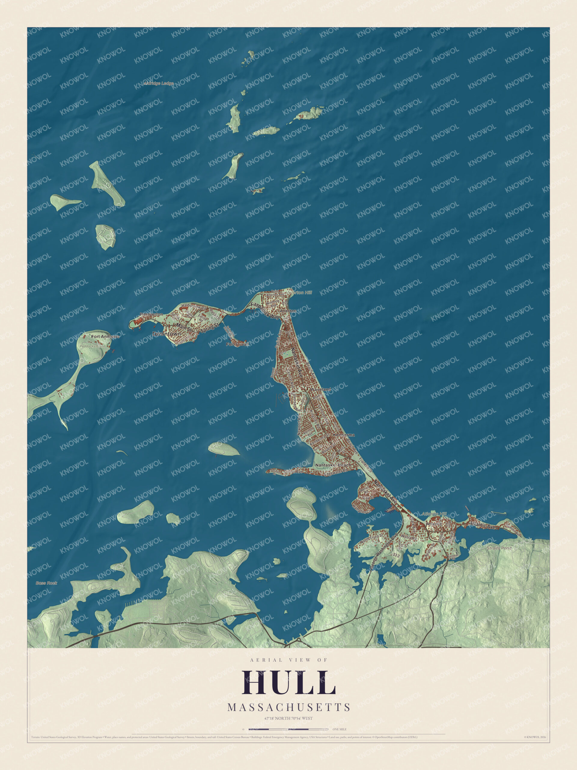
The whole Nantasket Peninsula in the look of an old atlas, with Nantasket Avenue, Main Street and Atlantic Avenue, Nantasket Beach, Straits Pond, Allerton Hill and Atlantic Hill.5
The story of Hull
A letter from Hull in 1845
In 1845 someone who knew Hull well wrote a long letter about it, and the county history of 1884 printed it. Hull then had about twenty-five houses, half as many as in 1775, and ten or twelve schooners in lumbering, lightering and fishing. The town had voted back in 1721 that no tavern could be kept there, so a man who wanted a drop had to send to Boston. There was no settled minister either. The writer joked that almost every citizen of Hull had a religion of his own, and that the last minister, a stout man when he came, left very lean. Up on the hill stood the telegraph and the old Revolutionary fort, with a well ninety feet deep whose bottom was still twenty-five feet above the road.6789
Joshua James and the great storm of 1888
The 1845 letter called Hull a great place for wreckers and for wrecks, and the Humane Society kept lifeboats here at Stony Beach and on Nantasket Beach. Joshua James, born in Hull, went out in those boats for decades. In the storm of November 25 and 26, 1888, he and his crews saved 29 people from five wrecked vessels. Congress gave him a special gold medal for the wreck of the schooner Gertrude Abbot, and the Humane Society gave him another for the whole storm. The next year the government opened Point Allerton Life Saving Station and made him its first keeper. The town page estimates he and his crews saved more than 1,000 people, and the station is now the Hull Lifesaving Museum.93110
Hotels, yachts and the beach railroad
Hull became a resort in 1825, when Paul Worrick opened the Sportsman Hotel on Nantasket Avenue. In 1848 the Oregon House went up in Hull village, built from the old barracks at Castle Island. By 1884 the Nantasket Beach Railroad ran the length of the beach to Windmill Point, where trains stopped right in front of the mammoth Hotel Pemberton. The Hull Yacht Club had nearly five hundred members, and its 1890 clubhouse looked out on a basin full of sails. In 1890 the town had 561 houses, counting the hotels, and only 451 people who lived here all year. Paragon Park came later, and its 1928 carousel, with 66 horses, still turns beside Nantasket Avenue.111121314
Through the years
22 moments from 1621 to today.
- 1621Plymouth Colony sets up a trading post on Nantasket to trade with the Wampanoag.1
- 1622Thomas and John Gray and Walter Knights settle near Nantasket, by the account of an 1893 guide.12
- 1634William Wood's map marks the point as Allerton Poynt.15
- 1644Hull is incorporated, with twenty houses, a fort and a church.2
- 1679People of Hull and Hingham get leave to dam Straits Pond for a mill.16
- 1721Town meeting votes that no tavern may be kept in Hull.7
- 1776A fort called Fort Independence is built on Allerton Point.1
- 1798Rev. Jesse Lee preaches the first Methodist sermon in Hull.17
- 1803Hull leaves Suffolk County and joins Plymouth County.1
- 1815The town's church is blown down in the great September gale.2
- 1825Paul Worrick opens the Sportsman Hotel on Nantasket Avenue.1
- 1827The first telegraph tower goes up on Telegraph Hill.18
- 1845A letter writer counts about twenty-five houses, half as many as in 1775.6
- 1848The Oregon House is built from the old barracks at Castle Island.11
- 1888In one November storm Joshua James and his crews save 29 people from five wrecks.3
- 1889Point Allerton Life Saving Station opens with Joshua James as its first keeper.1
- 1890Hull counts 561 houses, hotels included, and 451 year-round people.13
- 1895The Hull branch becomes the first electrified railroad in America, by the town page's account.1
- 1901Fort Revere is built on the site of the Revolutionary fort.1
- 1927Fort Duvall is finished on Hog Island with 16-inch guns.1
- 1928The Philadelphia Toboggan Company builds the Paragon Park Carousel.14
- 1984Paragon Park closes; the carousel stays.1
Places to see
Places worth a visit in Hull today.
- Nantasket BeachNantasket. Three miles of fine gray sand.Visit their website
- Paragon Park CarouselNantasket Avenue. The 1928 carousel with 66 horses.Visit their website
- Point Allerton Station1117 Nantasket Avenue. Now the Hull Lifesaving Museum.Visit their website
- Fort Revere ParkTelegraph Hill. Two forts and an observation tower.Visit their website
- Allerton HillAllerton. A glacial drumlin over the harbor.
- Atlantic HillSouthern Hull. A hill above the open ocean.
- Straits PondCohasset line. Dammed for a mill in 1679.
- Pemberton PointHull Village. The tip, where the Boston ferry leaves.
- Fort AndrewsPeddocks Island. Guarded the harbor from 1904.
- Fort DuvallSpinnaker Island. 16-inch guns finished in 1927.
On the National Register
All 5 places in Hull on the National Register of Historic Places that still stand today, oldest first, and why each one matters.4
-
Telegraph Hill
A fort first stood here in 1776 to defend Boston, and the first telegraph tower went up in 1827; telegraph stations used the hill until 1938. Its 1903 concrete water tower, one of the earliest in the country, now crowns Fort Revere Park.18
-
Point Allerton Lifesaving Station
Built in 1889 by the Army Corps of Engineers for the U.S. Life-Saving Service, with Hull native Joshua James as its first keeper. It is the best-preserved of 32 stations that once lined the Massachusetts coast, and is now the Hull Lifesaving Museum.19
-
Paragon Park Carousel
Built in 1928 by the Philadelphia Toboggan Company, with 66 horses, 42 of them moving. It is one of the state's only surviving four-wide carousels and the only piece of Paragon Park left.14
-
Boston Harbor Islands Archeological District
Twenty-one harbor islands hold archaeological traces of thousands of years of life by the Indigenous people of Massachusetts. Hull's share is Peddocks Island; the district reaches into Boston, Quincy, Hingham and Weymouth too.20
-
Hull Shore Drive, Nantasket Avenue, Metropolitan Park System of Greater Boston MPS
A 1.25-mile stretch of the coastal parkway beside Nantasket Beach, part of the Metropolitan Park System of Greater Boston. Nantasket Avenue is the main road through Hull.21
In their words
“As goes Hull so goes the state.”
Tourists' guide to Down the Harbor, Hull and Nantasket, 1893, on the town's famous vote12
“Hull is a great place for wreckers and for wrecks.”
An 1845 letter, printed in the History of Plymouth County, 18849
“It is at Nantasket that old ocean can be studied in all its thousand phases”
History of Plymouth County, 188422
Nearby towns
Sources
- Hull, Massachusetts, Wikipedia
- History of Plymouth, Norfolk and Barnstable counties, Massachusetts (1928), on Hull, Internet Archive
- Tourists' guide to Down the Harbor, Hull and Nantasket (1893), on Joshua James's medals, Internet Archive
- National Register of Historic Places listings in Plymouth County, Massachusetts, Wikipedia
- Map of Hull, Massachusetts in 2026, KNOWOL (USGS elevation, Census Bureau roads)
- History of Plymouth County, Massachusetts (1884), on Hull in 1845, Internet Archive
- History of Plymouth County, Massachusetts (1884), on the 1721 tavern vote, Internet Archive
- History of Plymouth County, Massachusetts (1884), on Hull's ministers in 1845, Internet Archive
- History of Plymouth County, Massachusetts (1884), on wreckers and the old fort, Internet Archive
- Joshua James (lifesaver), Wikipedia
- History of Plymouth County, Massachusetts (1884), on Hull village hotels, Internet Archive
- Tourists' guide to Down the Harbor, Hull and Nantasket (1893), Internet Archive
- A gazetteer of the state of Massachusetts (1890), on Hull, Internet Archive
- Paragon Park Carousel, Wikipedia
- King's handbook of Boston harbor (1888), on Point Allerton, Internet Archive
- History of the town of Hingham, Massachusetts (1893), on the Straits Pond mills, Internet Archive
- History of Plymouth County, Massachusetts (1884), on the Methodist church in Hull, Internet Archive
- Telegraph Hill, Wikipedia
- Point Allerton Lifesaving Station, Wikipedia
- Boston Harbor Islands Archeological District, Wikipedia
- Hull Shore Drive, Nantasket Avenue, Metropolitan Park System of Greater Boston MPS, Wikipedia
- History of Plymouth County, Massachusetts (1884), on Nantasket Beach, Internet Archive