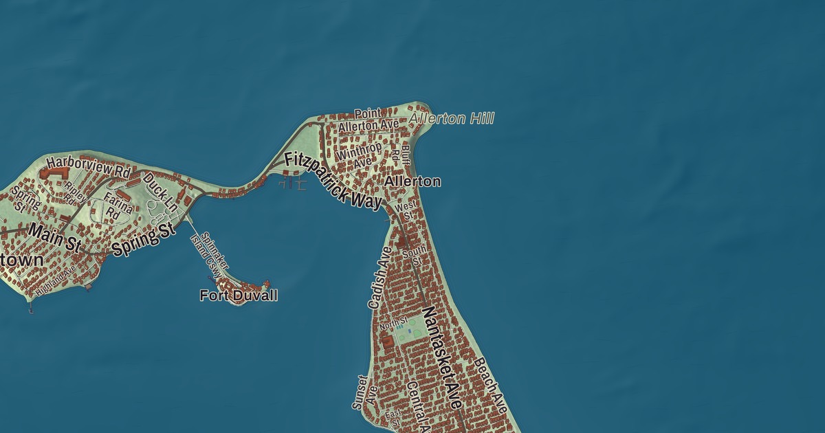
Hull sits on a narrow peninsula at the southern edge of Boston Harbor. This map prints Nantasket Avenue, Atlantic Avenue, Main Street, Fitzpatrick Way, Spring Street and Franklin Street, with Nantasket Beach, Straits Pond, Allerton Hill and Atlantic Hill. Click here to purchase a print of this map for your wall.
Hull is in Plymouth County.
KNOWOL made this map in 2026 from public survey data and gave it the look of an old atlas. The relief comes from United States Geological Survey elevation data, and the streets and the town line come from the Census Bureau. Hull’s 26.9 square miles are mostly water; only 2.8 square miles are land. The Nantasket Peninsula juts into Massachusetts Bay with Hingham Bay to the west, and the Weir River estuary separates it from Cohasset and Hingham. By land Hull is almost 20 miles from Boston, but by water it’s just 5 miles from Pemberton Point to South Boston. The town had 10,072 people at the 2020 census.
Nantasket, the low-tide place
The Massachuset people called this place Nantasket, which the town page translates as “at the strait” or “low-tide place.” It’s a chain of islands joined by sandbars, and Plymouth Colony set up a trading post here in 1621 to trade with the Wampanoag. The Town of Hull’s recorded history, in the Secretary of the Commonwealth’s list, dates European settlement to 1624, while the town page gives 1622. Roger Conant spent time here after leaving Plymouth and before going to Cape Ann in 1625. Hull was incorporated as a town in 1644, named for Kingston upon Hull in England. Early residents fished, traded and salvaged wrecks. Hull began in Suffolk County and moved to Plymouth County in 1803, and the town remains part of Plymouth County today.
The hills that rise along the peninsula, Allerton Hill and Telegraph Hill among them, are drumlins left by the last glacier about 14,000 years ago, and the low land between them is made of tombolos, the sand bars that tie them together. In 1776 Patriot forces built a fort called Fort Independence on Allerton Point, and Fort Revere was built on the same ground in 1901. Today Fort Revere Park on Telegraph Hill keeps the remains of both forts, with an observation tower that looks out over Boston Harbor.
Joshua James and the lifesavers
Lifesaving is a big part of Hull’s story. The Massachusetts Humane Society placed one of its first huts of refuge on Nantasket Beach after the Revolution, and later boat houses for lifeboats around town. Joshua James, born in Hull in 1826, joined his first rescue at 15 and spent six decades rescuing people from shipwrecks. His page credits him with more than 500 lives, and the town page estimates that he and his crews saved more than 1,000; no one knows the exact number, because the Humane Society’s records were lost in the Great Boston Fire of 1872. When the U.S. Life-Saving Service opened Point Allerton Station in 1889, James was 62, well past the age limit, and Congress made a special provision so he could be its first keeper. The station, at 1117 Nantasket Avenue, is now the Hull Lifesaving Museum, and its page calls it the best-preserved of 32 stations that once lined the Massachusetts coast.
Nantasket Beach has fine, light gray sand and acres of tide pools at low tide. Hull’s life as a resort began in 1825, when Paul Worrick opened the Sportsman Hotel on Nantasket Avenue, and by 1840 steamboats ran three trips a day to Boston. Calvin Coolidge and Boston mayor John F. Fitzgerald, grandfather of John F. Kennedy, spent summers here. The Paragon Park amusement park closed in 1984, and its 1928 carousel, with 66 horses, still stands beside Nantasket Avenue. The town page notes that the Hull branch railroad, in 1895, was the first electrified railroad in America. Click here to learn more about the history of Hull.
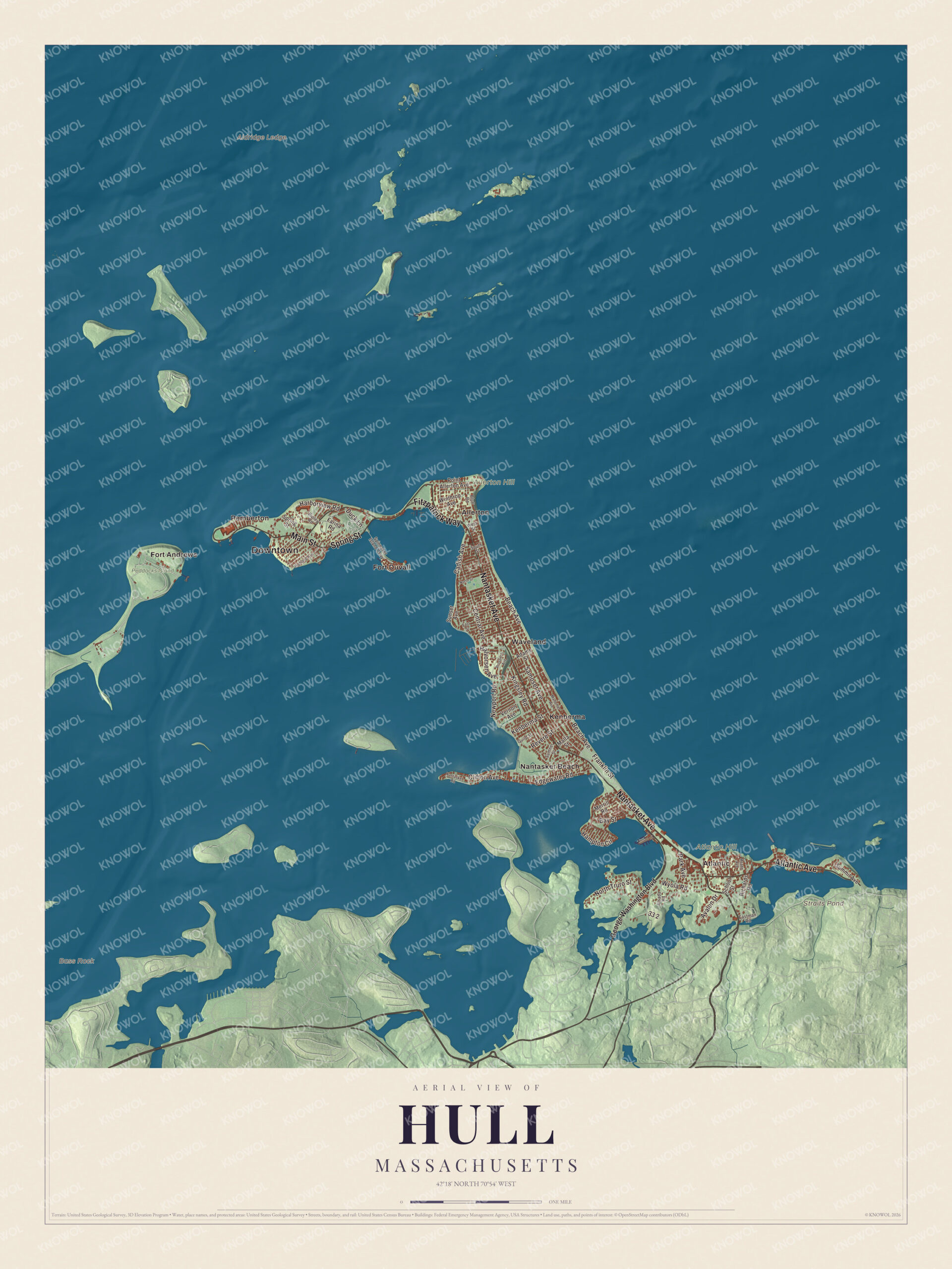
Click to explore a larger preview. The digital watermark does not appear on printed maps.
Names on this map
These names are printed on this map.
Places: Downtown, Aldridge Ledge, Allerton Hill, Atlantic Hill, Bass Rock, Straits Pond, Peddocks Island, Allerton, Atlantic, Fort Andrews, Fort Duvall, Kenberma, Nantasket Beach, Pemberton and Waveland.
Streets and roads: Nantasket Avenue, Atlantic Avenue, Main Street, Fitzpatrick Way, Spring Street, Franklin Street, Avalon Drive, Newport Road, Bay Street, Beach Avenue, Samoset Avenue, Cadish Avenue.
More street names, A to Z
Adams Street, Alsada Road, Bluff Road, Central Avenue, Clifton Avenue, Duck Lane, Eastman Road, East Street, Edgewater Road, Farina Road, George Washington Boulevard, Guild Street, Halvorsen Avenue, Hampton Circle, Harborview Road, Highland Avenue, Kenberma Street, Kingsley Road, Malta Street, Manomet Avenue, Meade Avenue, Merrill Road, Nantasket Road, North Street, North Truro Street, Park Avenue, Point Allerton Avenue, Prospect Avenue, Revere Street, Richards Road, Ripley Road, School Street, South Street, Spinnaker Island Causeway, Summit Avenue, Sumner Street, Sunset Avenue, Vernon Avenue, West Street, Winthrop Avenue, Wyola Road.
See it on a wall
The Hull map as a framed print. Swipe for more.


Around the map
Start with Allerton, then follow Nantasket Avenue, Atlantic Avenue, Main Street, Fitzpatrick Way, Spring Street and Franklin Street across town. Route 228 becomes Nantasket Avenue at the center entrance to town, and the avenue runs on to Main Street in Hull Village, which passes the Coast Guard station and ends at Pemberton Point, where the ferry leaves for Boston. Look outward toward Atlantic, Fort Andrews, Fort Duvall, Kenberma and Nantasket Beach. Fort Andrews stood on the eastern end of Peddocks Island, part of Hull, and guarded the harbor from 1904 through World War II; it’s no longer active. Fort Duvall was finished in 1927 on Hog Island, now Spinnaker Island, armed with 16-inch guns; the island has since been developed with condominiums. Straits Pond, Allerton Hill and Atlantic Hill are all printed on the map, and every one of those names is right there on the artwork.
The Hull map makes a fine addition to an office, library or den, and it can help teach children the geography and history of a town of lifesavers. It’s made for people who call Hull home, from Kenberma to Allerton, and it shows the town as it looks today. Zoom in on the preview above to explore the details, then click here to get your copy of the Hull, Massachusetts map.

Sources
- Hull, Massachusetts, Wikipedia
- Joshua James (lifesaver), Wikipedia
- Point Allerton Lifesaving Station, Wikipedia
- Fort Revere, Wikipedia
- Nantasket Beach, Wikipedia
- Paragon Park Carousel, Wikipedia
- Peddocks Island, Wikipedia
- City and Town Incorporation and Settlement Dates, Secretary of the Commonwealth of Massachusetts (archived copy)