
The western end of Martha's Vineyard and the home of the Wampanoag Tribe of Gay Head (Aquinnah), where the many-colored clay cliffs and the Gay Head Light look out over Devil's Bridge, and where Moshup is said to have roasted whales in his den.
Then and now
The same town 72 years apart. Click either map to look closer.
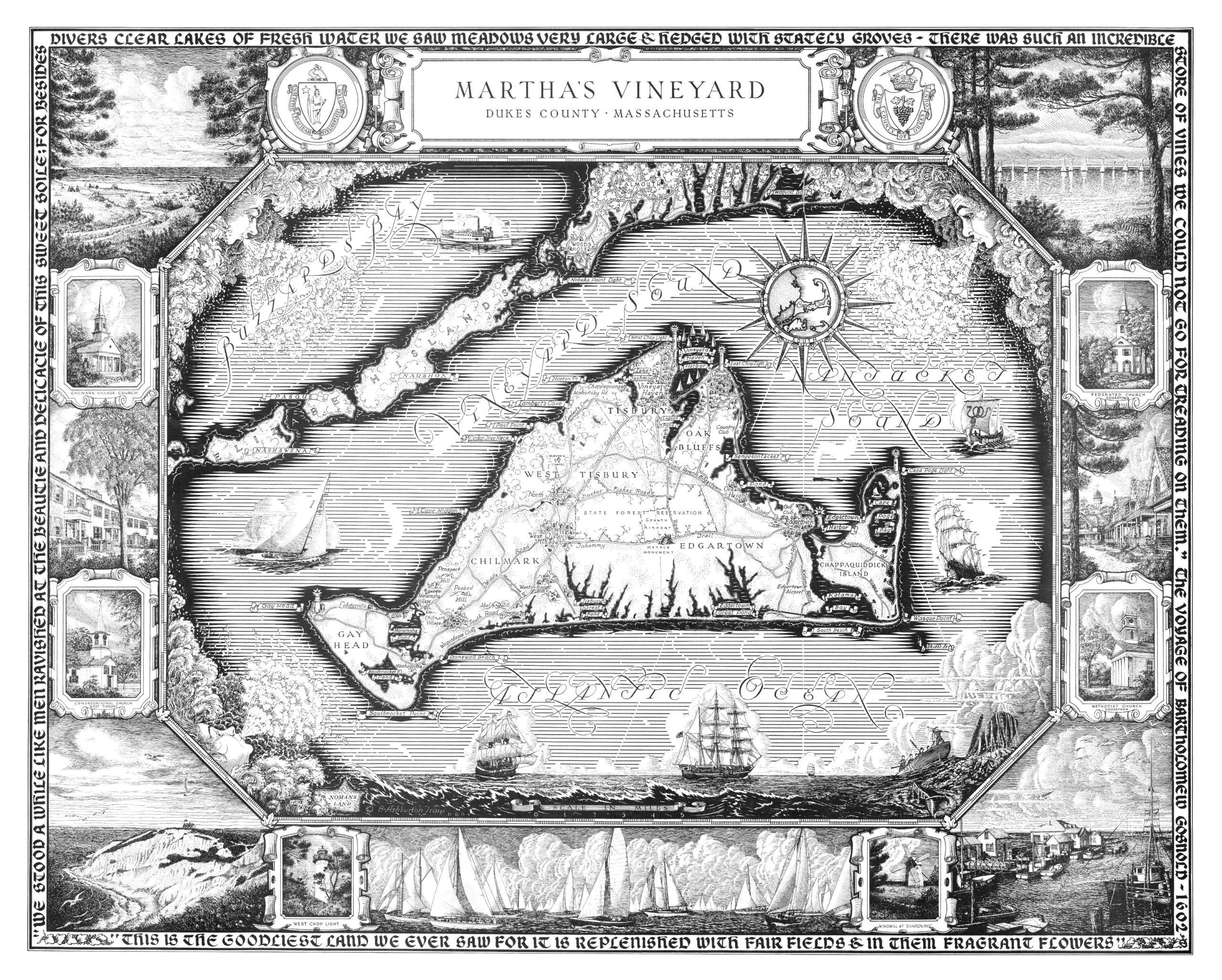
Martha's Vineyard in 1954
By Maker not named
A pictorial map of the whole island of Martha's Vineyard, Gay Head included, framed by maritime scenes, churches and the Greek wind gods, with the words Bartholomew Gosnold wrote about the island on his voyage of 1602.4
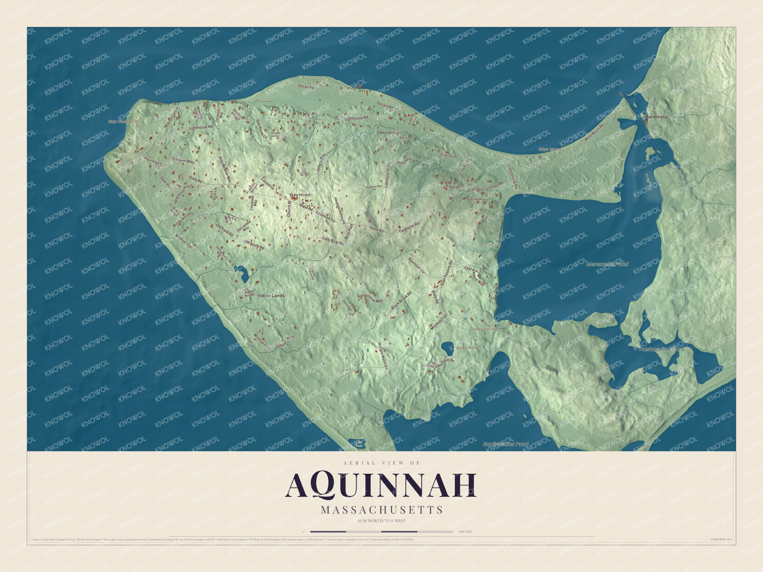
Aquinnah today
By KNOWOL
Shaded terrain over heathland, woods, high dunes and the clay cliffs, with State Road, Moshup Trail, Lighthouse Road and Lobsterville Road, and Menemsha Pond and Squibnocket Pond on the town's eastern edge.5
The story of Aquinnah
The night the Columbus struck Devil's Bridge
Early on a January morning in 1884, the steamer City of Columbus, bound from Boston for Savannah, ran onto Devil's Bridge, the ledge of rocks off the cliffs. Most aboard were asleep below, and the survivors clung to the rigging in a freezing sea. Word went to the Gay Head homes, and a volunteer crew under Joseph Peters rowed the lifeboat out through heavy surf. They left so fast they forgot their cork jackets, and one man went barefoot. They brought seven people ashore, and a second crew went out and saved thirteen more. Twenty of the twenty-six survivors came off in that Gay Head boat, and each of the twelve men got a silver medal from the Massachusetts Humane Society. The sea took 121 lives that night.6789
Moshup's den and the crab
The old stories of Gay Head belong to Moshup, a giant who lived in the Devil's Den, a bowl-shaped hollow in the cliffs about a hundred feet deep and open to the sea. He pulled trees up by the roots to make his fires and roasted whales on them, and he sent whales and fish ashore for the people. One story says he started a causeway of rocks out toward Cuttyhunk, the reef now called Devil's Bridge, and gave it up when a crab bit his toe. Another says the first person to reach the island came over on a cake of ice with his dog and found Moshup already here. The beach below the cliffs still carries his name.1011121
A town of its own
Gay Head people ran their own affairs long before the state said so. In 1714 they met on their own and fenced off the Neck. Around 1807 they sold clay from the cliffs for three dollars a ton, more if they carried it to market, sold cranberries from their bogs, and dug a canal so the alewives could reach Squibnocket Pond. Gay Head whalemen were known for getting the best shares on a whaler. In 1870 a committee of the legislature reported that they had been governing themselves since 1862, that all but one wanted a town of their own, and Gay Head was incorporated. In 1997 the town took back its Wampanoag name, Aquinnah.13141516171
Through the years
20 moments from Ancient to today.
- AncientArchaeologists date the first signs of people here to between 10,000 and 7,500 years ago.1
- 1602Bartholomew Gosnold sails past the cliffs and names them Dover Cliff.18
- 1669The state's list dates European settlement of the area to this year.5
- 1702Gay Head's Baptist church has about 30 members, the start of what becomes the town's only church.19
- 1714Judge Samuel Sewall hears that the Gay Head community has built a fence across the Neck on its own.13
- 1799Ebenezer Skiff lights the first Gay Head Light, a wooden tower and the first lighthouse on Martha's Vineyard.20
- 1807Gay Head families sell clay from the cliffs by the ton and cranberries by the bushel.14
- 1807A newly dug canal lets alewives pass from Menemsha Pond into Squibnocket Pond.15
- 1844Gay Head has 235 people and a Baptist church led by Rev. Joseph Amos, a blind preacher from Mashpee.11
- 1850The Gay Head Community Baptist Church is dedicated in December.21
- 1856The red brick lighthouse is lit, with a French lens of more than a thousand prisms.20
- 1870A legislative committee finds Gay Head has governed itself since 1862, and it becomes the town of Gay Head.17
- 1884The steamer City of Columbus strikes Devil's Bridge, and Gay Head lifeboat crews bring twenty survivors ashore.7
- 1902Amos Smalley, a Wampanoag whaleman, harpoons a white sperm whale south of the Azores.5
- 1929The present town hall is built in the town center.21
- 1952The great lens comes out of the lighthouse and goes to the island museum in Edgartown.20
- 1965The Gay Head Cliffs are named a National Natural Landmark.1
- 1987The Wampanoag Tribe of Gay Head (Aquinnah) wins federal recognition.1
- 1997By a vote of 79 to 76, Gay Head changes its name to Aquinnah, Wampanoag for land under the hill.1
- 2015With the cliff edge wearing away, Gay Head Light is moved 129 feet inland.20
Places to see
Places worth a visit in Aquinnah today.
- Gay Head LightLighthouse Road. Moved 129 feet inland in 2015.Visit their website
- Gay Head CliffsWestern end of the island. National Natural Landmark since 1965.
- Moshup BeachOff Moshup Trail. Named for the giant Moshup.
- Aquinnah CircleNear the cliffs. Named a cultural and historical site.
- Devil's BridgeOffshore, Vineyard Sound. Reef of underwater rocks off the cliffs.
- Lobsterville BeachNorth shore at Dogfish Bar. Known for surf fishing.
- Philbin BeachOff Moshup Trail. Beach on the south shore.
- Herring CreekBetween the two ponds. The tribe's herring run and hatchery.
- Menemsha PondEastern edge, shared with Chilmark. Salt pond where the tribe raises oysters.
- Squibnocket PondEastern edge, shared with Chilmark. Where the herring swim to spawn.
On the National Register
All 3 places in Aquinnah on the National Register of Historic Places that still stand today, oldest first, and why each one matters.3
-
Gay Head-Aquinnah Town Center Historic District
The heart of town: a schoolhouse known by 1844 that is now the town library, the Gay Head Community Baptist Church of 1850, its parsonage of 1856, the 1929 town hall, the old post office and two World War I monuments. Most of the buildings were moved here after the town was incorporated in 1870.21
-
Gay Head-Aquinnah Light
The red brick tower on the westernmost point of Martha's Vineyard replaced the island's first lighthouse, a wooden tower of 1799, and guards ships from Devil's Bridge. It was moved 129 feet inland in 2015 as the cliffs wore away.20
-
Edwin DeVries Vanderhoop Homestead
The first house built by the Vanderhoop family, prominent in town and tribal affairs. Edwin DeVries Vanderhoop was a whaling captain and the first Wampanoag to sit in the state legislature. It is now the Aquinnah Cultural Center, with exhibits on tribal history and culture.22
In their words
“I have never seen anything that in mystic splendor equalled this trick of the magic lantern of Gay Head.”
A visitor on the Gay Head Light, quoted in The history of Martha's Vineyard, 191123
“Cut into innumerable forms by the incessant action of the sea, this beetling headland, belted with rainbow-colors, awakens the admiration of the seamen coming towards the coast”
Gazetteer of the state of Massachusetts, 1874, on the cliffs2
“because the people of Gay Head are (with one exception) unanimous for a separate township; because other things being equal, the wishes of the parties most interested ought to be consulted”
The legislative committee of 1870, quoted in The history of Martha's Vineyard, 191117
Nearby towns
Sources
- Aquinnah, Massachusetts, Wikipedia
- Gazetteer of the state of Massachusetts (1874), on Gay Head, Internet Archive
- National Register of Historic Places listings in Dukes County, Massachusetts, Wikipedia
- Map of Martha's Vineyard from 1954, restored by KNOWOL
- Map of Aquinnah, Massachusetts in 2026, KNOWOL (USGS elevation, Census Bureau roads)
- Genealogical and personal memoirs relating to the families of Boston and eastern Massachusetts (1908), on the City of Columbus, Internet Archive
- The Humane Society of the Commonwealth of Massachusetts: an historical review, 1785-1916 (1918), on the Gay Head lifeboat, Internet Archive
- The Humane Society of the Commonwealth of Massachusetts: an historical review, 1785-1916 (1918), on the medals, Internet Archive
- The history of Martha's Vineyard, Dukes County, Massachusetts (1911), on the wreck of the City of Columbus, Internet Archive
- Collections of the Massachusetts Historical Society, second series, vol. 3 (1815), James Freeman's Description of Dukes County (1807), on the light and the Devil's Den, Internet Archive
- Historical collections, relating to the history and antiquities of every town in Massachusetts (1844), on Gay Head, Internet Archive
- The history of Martha's Vineyard, Dukes County, Massachusetts (1911), on the Moshup traditions, Internet Archive
- Diary of Samuel Sewall, Collections of the Massachusetts Historical Society (1869), April 1714, Internet Archive
- Collections of the Massachusetts Historical Society, second series, vol. 3 (1815), James Freeman's Description of Dukes County (1807), on Gay Head, Internet Archive
- Collections of the Massachusetts Historical Society, second series, vol. 3 (1815), James Freeman's Description of Dukes County (1807), on Squibnocket, Internet Archive
- The maritime history of Massachusetts, 1783-1860 (1921), on whaling, Internet Archive
- The history of Martha's Vineyard, Dukes County, Massachusetts (1911), on the incorporation of Gay Head, Internet Archive
- Historical collections, relating to the history and antiquities of every town in Massachusetts (1841), on Dukes County, Internet Archive
- Publications of the Colonial Society of Massachusetts, vol. 38, on the Gay Head Baptist church, Internet Archive
- Gay Head Light, Wikipedia
- Gay Head-Aquinnah Town Center Historic District, Wikipedia
- Edwin DeVries Vanderhoop Homestead, Wikipedia
- The history of Martha's Vineyard, Dukes County, Massachusetts (1911), on the 1856 lighthouse, Internet Archive