
Once the largest town in Massachusetts, Framingham grew as a ring of villages, from the mill falls at Saxonville to the old common at Framingham Center and the straw shops and rail yards of South Framingham.
Framingham on the map
Click the map to look closer.
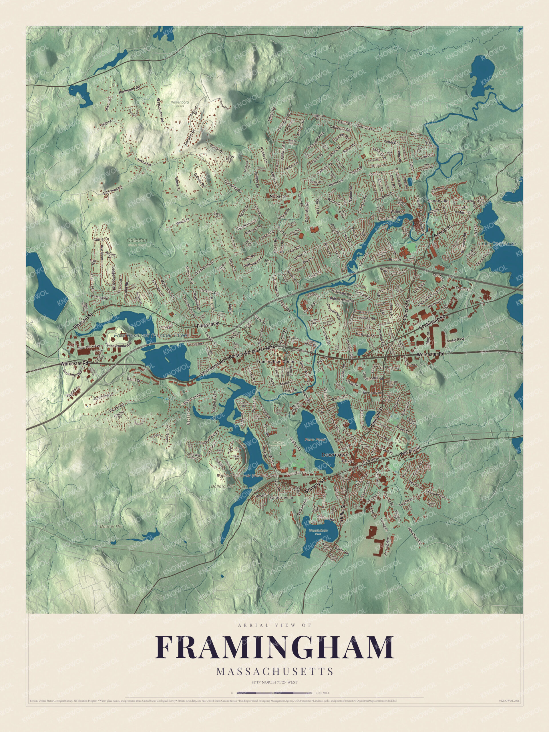
Framingham today
By KNOWOL
Shaded relief from Saxonville on the Sudbury River to Nobscot, with Concord Street, Hollis Street, Worcester Road, Pleasant Street and Waverly Street, Farm Pond, Lake Cochituate, the Bracket and Foss reservoirs, and Bare, Ballard and Banner hills.4
The story of Framingham
The straw bonnet trade
Framingham's first big trade started at home. In 1799 or 1800 the wife of Joseph Bennett and her daughter Betsey began plaiting grass and rye straw into hats and bonnets. A note dated October 2, 1800 marks the day Mary Rice started on straw bonnets, and she kept at it for about fifty years, selling in Boston, Salem, Gloucester and Portland. Benjamin Wheeler's bonnet trade with the South reached $30,000 in some years. In South Framingham, Alexander Clark opened a straw shop in 1838, and before the village had a church of its own, the Bible was read aloud there on weekdays. By 1874 the village had three large straw-hat works with about 150 workers each, turning out as many as fifty styles of bonnets a season.5678
A field white with tents
Summer in South Framingham meant crowds by Farm Pond. Harmony Grove, on its eastern shore, was for years a favorite picnic ground for nearby towns and for Boston, and from 1854 to 1865 the antislavery rallies met there every Fourth of July. In 1871 a camp-meeting association bought forty-five acres at the north end of the pond, Mount Wayte included, and called it Lakeview. Methodist camp meetings came first, then the New England Chautauqua Sunday-school Assembly, which drew many thousands of visitors. In 1873 the Commonwealth bought about 115 acres for the State Muster-Field. Two brigade musters a year brought about 2,500 militia each time, and the 1890 county history says the field was then white with tents, with the street cars running right past it.911011
The Falls, the Centre and the South village
Framingham grew as a ring of villages. John Stone built the first corn mill at the falls of the Sudbury River in 1659, and the place was long called The Falls before it was Saxonville. Thomas Danforth gathered more than 15,000 acres here, and the town was incorporated in 1700, the year after he died. The Sherborn line took longer. Not until June 16, 1710 did the General Court put seventeen disputed families inside Framingham forever, giving Sherborn 4,000 acres west of Mendon instead. In 1800 the Centre was a few houses around the meetinghouse, and South Framingham had a tavern, a cider mill and a store. Straw works and the railroad built up the South village, and in 1888 a horse railway tied the three together, with Uncle Dexter Hemenway, the oldest man in town, on the first car.1211314
Through the years
25 moments from 1647 to today.
- 1647John Stone, the first English settler, builds a farm on the west bank of the Sudbury River.1
- 1654The great stone heap on the top of Nobscot is already named in the records.15
- 1659John Stone builds the first corn mill at the falls, the place later called Saxonville.12
- 1660Thomas Danforth receives the land grant that becomes Danforth's Farms.1
- 1700Framingham is incorporated as a town, the year after Danforth's death.1
- 1710The General Court ends a long border fight with Sherborn and puts seventeen families inside Framingham for good.13
- 1775About 130 Framingham men march to the battles of Lexington and Concord.1
- 1792Townsmen tax themselves to build the brick schoolhouse that becomes Framingham Academy.16
- 1800Mary Rice starts making straw bonnets, a trade she keeps up for about fifty years.5
- 1846The Framingham Savings Bank is chartered and opens at the Centre that May.17
- 1853The state normal school, the first in the country, moves to Framingham.4
- 1854The Massachusetts Anti-Slavery Society holds the first of its Fourth of July rallies at Harmony Grove on Farm Pond.1
- 1858Michael H. Simpson and Nathaniel Francis buy the whole Saxonville mill plant.18
- 1871A camp-meeting association buys 45 acres at the north end of Farm Pond, the start of Lakeview.10
- 1873The Commonwealth buys about 115 acres for the State Muster-Field.11
- 1875South Framingham's three straw goods factories turn out $830,000 worth of goods.6
- 1884H. H. Richardson's new railroad station goes up in South Framingham.19
- 1888The Framingham Union Street Railway opens on May 29, tying the villages together.14
- 1897Dennison Manufacturing moves to South Framingham.20
- 1900At least 10,000 people watch the bicentennial fireworks at the Saxonville Mill Pond.2
- 1905The Minute Man statue by Henry H. Kitson and Theo Alice Ruggles Kitson is dedicated on June 17.21
- 1906The Amsden Building on Concord Street collapses, killing 12 people.1
- 1948The Framingham Heart Study begins with 5,209 adults from the town.4
- 1951Shoppers' World opens, the second open-air mall in the country.1
- 2018Framingham becomes a city, and Yvonne Spicer is sworn in as its first mayor.1
Places to see
Places worth a visit in Framingham today.
- SaxonvilleOn the Sudbury River. Mill village at the old falls.
- Framingham CenterAround the old common. The town's early center.
- Nobscot HillNobscot. Summit view reaches Boston and Monadnock.
- Farm PondNear downtown. The Nipmuc's Washakamaug, eel fishing place.
- Lake CochituateEast, shared with Natick and Wayland. Boston's first major water supply.
- Bracket ReservoirOff Winter Street. Reservoir No. 2, built 1877 to 1879.
- Foss ReservoirOff Route 9. Largest of the three Framingham reservoirs.
- Framingham State UniversityBare Hill. The first state normal school, here since 1853.Visit their website
- Garden in the WoodsNorth Framingham. Wildflower garden founded in 1931.Visit their website
- Callahan State ParkFramingham and Marlborough. 958 acres, mostly in Framingham.Visit their website
On the National Register
All 20 places in Framingham on the National Register of Historic Places that still stand today, oldest first, and why each one matters.3
-
Saxonville Historic District
The 19th century mill village at the heart of Saxonville, around the old mills at the junction of Water, Central, Elm and Concord Streets. The brick mill buildings went up after fires in the 1880s, and some of the workers' housing dates to the 1820s.22
-
First Baptist Church
Its cornerstone was laid in 1826 and the first service held on January 1, 1827. Apart from changes for access around 1998, the building stands much as it was built, and the original box pews survive in the balcony.23
-
Stone's Bridge
A four-arch granite bridge over the Sudbury River, built in 1858 by William Simonds and named for a local resident, not its stone. After Hurricane Diane's flood in 1955 the road moved to a new bridge to the south.24
-
Paul Gibbs House
Built in 1860 for a member of a prominent local family, it is a good example of Italianate architecture, probably the work of noted local architect Alexander Rice Esty. The house was listed on the National Register of Historic Places in 1983.25
-
Moses Ellis House
Local architect Alexander Rice Esty designed this house for Moses Ellis, a well-to-do farmer, with a porte cochere jutting from its front gable. In the early 1900s it was home to a school for boys.26
-
Saint John's Episcopal Church
Local architect Alexander Rice Esty, a member of the congregation, designed it and gave his services. Framingham State University bought the building in 1969, and it's now the Heineman Ecumenical Center.27
-
Sudbury Aqueduct Linear District
Built 1875 to 1878, it carried water 16 miles from Farm Pond in Framingham to the Chestnut Hill Reservoir, crossing the Charles River on the Echo Bridge, and was in use for almost 100 years.28
-
Framingham Reservoir No. 1 Dam and Gatehouse
Built 1876 to 1878 to expand Boston's water supply, at the end of the reservoir also called the Stearns Reservoir. Its granite gatehouse, designed by Boston city architect George A. Clough, controlled the flow from all three Framingham reservoirs into the Sudbury Aqueduct.29
-
Framingham Reservoir No. 3 Dam and Gatehouse
The dam and gatehouse at the southeastern end of Reservoir No. 3, the Foss Reservoir, off Route 9. They were built 1876 to 1878 as part of an expansion of the public water supply of the city of Boston.30
-
Framingham Reservoir No. 2 Dam and Gatehouse
The dam and gatehouse are located west of the junction of Winter and Fountain Streets and impound a branch of the Sudbury River. The reservoir, also known as the Brackett Reservoir, was built between 1877 and 1879 as part of an expansion of the water supply for the city of Boston.31
-
Framingham Railroad Station
Designed by H. H. Richardson and built in 1884 to 1885, it was one of the last stations he designed in the Northeast, a hub for branch lines to Milford, Mansfield, Fitchburg and Lowell. Restored in the 1980s, it's now a restaurant.19
-
Concord Square Historic District
Downtown business blocks from the corner of Concord and Union Streets south to the South Framingham Common and west along Park Street, mostly built between 1890 and 1920. The oldest is the Wallace Nutting Factory at 46 Park Street, from the early 1870s.32
-
Lake Cochituate Dam
The 62-foot dam was built in 1890, replacing two wooden dams that went back to the 1846 building of the Cochituate Aqueduct. The lake left Boston's water supply in the 1930s and became Cochituate State Park.33
-
Sudbury Dam Historic District
The Sudbury Dam of 1894 holds back the Sudbury Reservoir, and the district below it keeps water works from three stages of Greater Boston's supply, including the 1903 head house of the Weston Aqueduct.34
-
Weston Aqueduct Linear District
Built 1901 to 1903 to carry water 13.5 miles from the Sudbury Dam to the Weston Reservoir, with buildings by Shepley, Rutan and Coolidge and an open channel landscaped by the Olmsted Brothers.35
-
Whit's Diner
Built in 1942 by the Worcester Lunch Car Company as diner number 783, it ran as Whit's in Orange until about 1960. Richard and Joan Lloyd bought it in 1990 and moved it to Fountain Street, where it's Lloyd's Diner.36
-
Irving Square Historic District
It encompasses a portion of the town's central business district just south of the railroad tracks. It includes buildings on Hollis Street, extending south from Irving Street to Gordon Street, and buildings on Irving from Hollis to just beyond Columbia Street.37
-
Framingham Centre Common Historic District
The historic early center of Framingham, around the old town common west of Edgell Road. Its 28 buildings include the Village Hall, the old Edgell Memorial Library, First Parish Church and the former Framingham Academy building.38
-
R. H. Long Company Factory
A factory building at 59 Fountain Street, added to the National Register in 2023.3
-
Nobscot Union Chapel
A chapel at 871 Edgell Road, added to the National Register in 2023.3
In their words
“The instance was typical of the generosity of Framingham people, who have always known how to do a good thing when they saw a good thing to be done.”
A former Framingham minister, remembering the Chicago fire relief, Memorial of the bi-centennial celebration, 190039
“The town is considered very healthful; and the people are industrious, intelligent, courteous, and progressive.”
A gazetteer of the state of Massachusetts, 187440
“Framingham Center, whose old common is one of the best in this country, having no obnoxious features in its circuit and without the intrusion of shops or ruinous buildings.”
Massachusetts beautiful, 192341
Nearby towns
Sources
- Framingham, Massachusetts, Wikipedia
- Memorial of the bi-centennial celebration of the incorporation of the town of Framingham (1900), on the fireworks at Saxonville, Internet Archive
- National Register of Historic Places list, Wikipedia
- Map of Framingham, Massachusetts in 2026, KNOWOL
- History of Framingham, Massachusetts, early known as Danforth's Farms (1887), on straw braid and bonnets, Internet Archive
- History of Middlesex County, Massachusetts (1880), on the straw bonnet industry of South Framingham, Internet Archive
- History of Middlesex County, Massachusetts (1890), on the Baptist church of South Framingham, Internet Archive
- Gazetteer of the state of Massachusetts (1874), on Saxonville and the straw-hat works, Internet Archive
- Gazetteer of the state of Massachusetts (1874), on Farm Pond and Harmony Grove, Internet Archive
- History of Middlesex County, Massachusetts (1890), on Lakeview and the Chautauqua assembly, Internet Archive
- History of Middlesex County, Massachusetts (1890), on the State Muster-Field, Internet Archive
- Middlesex County and its people; a history (1927), on Framingham's villages in 1800, Internet Archive
- History of Middlesex County, Massachusetts (1890), on the Sherborn boundary, Internet Archive
- History of Middlesex County, Massachusetts (1890), on the Framingham Union Street Railway, Internet Archive
- History of Framingham, Massachusetts (1887), on the cairn on Nobscot, Internet Archive
- A gazetteer of Massachusetts (1847), on Framingham Academy, Internet Archive
- Inland Massachusetts illustrated (1891), on the Framingham Savings Bank, Internet Archive
- History of Framingham, Massachusetts (1887), on Michael H. Simpson and the Saxonville mills, Internet Archive
- Framingham Railroad Station, Wikipedia
- Town of Framingham, Massachusetts, past and present, progress and prosperity; souvenir (1906), on Dennison Manufacturing, Internet Archive
- History of the Massachusetts Daughters of the American Revolution (1905), on the Minute Man statue, Internet Archive
- Saxonville Historic District, Wikipedia
- First Baptist Church, Wikipedia
- Stone's Bridge, Wikipedia
- Paul Gibbs House, Wikipedia
- Moses Ellis House, Wikipedia
- Saint John's Episcopal Church, Wikipedia
- Sudbury Aqueduct Linear District, Wikipedia
- Framingham Reservoir No. 1 Dam and Gatehouse, Wikipedia
- Framingham Reservoir No. 3 Dam and Gatehouse, Wikipedia
- Framingham Reservoir No. 2 Dam and Gatehouse, Wikipedia
- Concord Square Historic District, Wikipedia
- Lake Cochituate Dam, Wikipedia
- Sudbury Dam Historic District, Wikipedia
- Weston Aqueduct Linear District, Wikipedia
- Whit's Diner, Wikipedia
- Irving Square Historic District, Wikipedia
- Framingham Centre Common Historic District, Wikipedia
- Memorial of the bi-centennial celebration of the incorporation of the town of Framingham (1900), on the Chicago fire relief, Internet Archive
- Gazetteer of the state of Massachusetts (1874), on the town and its people, Internet Archive
- Massachusetts beautiful (1923), on Framingham Center, Internet Archive