
A hill town on the Massachusetts line that grew up as Salmon Brook, the north end of old Simsbury, and lived on orchards, sawmills, tobacco and cider brandy, with 62 distilleries counted in 1828.
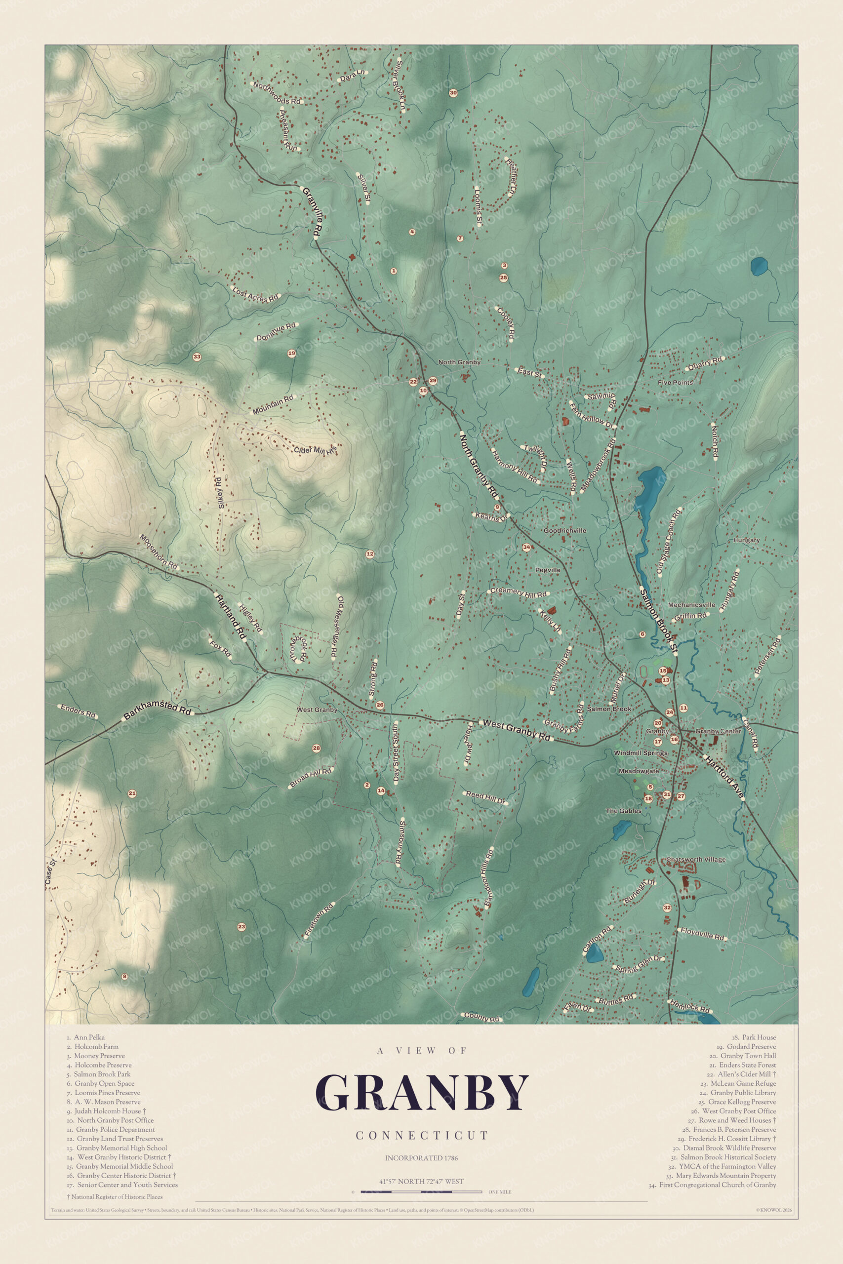
Granby on the map
Click the map to look closer.
Granby today
By KNOWOL
Shaded hills from Broad Hill and the Barn Door Hills down to Salmon Brook, every street, Granby Center, West Granby and Chatsworth Village, the Enders State Forest, and a guide of 34 numbered landmarks with the National Register sites marked.5
The story of Granby
Sixty-two stills and the Crag mills
Granby was apple country. An 1819 gazetteer put its orchards among the best in the state, and most of the cider ended up as cider brandy. By 1828 the town had 62 distilleries. In 1886 a county history still called West Granby a center for cider brandy stills. Up in North Granby the Godard family ran the Crag mills, a sawmill, gristmill and cider mill at a rocky gorge about a mile from the Cossitt Library. It was said every building in Tariffville once wore shingles cut there, and farmers who came to have their grain ground stayed to argue. Harvy Godard, who ran the mills and led the State Grange from 1875 to 1879, still made a little cider brandy each year the old way.6278910
Salmon Brook on the frontier
Granby began as Salmon Brook, the northern edge of Simsbury, and for years it was a risky place to live. In 1707 Daniel Hayes was taken in a raid and carried to Canada, and he didn't get home for years. A blockhouse called Shaw's Fort, thought to date from 1708, stood about a mile north of Salmon Brook Street, and settlers crowded into it when trouble came. At the time there were only fifty-eight houses in the whole tract, and in 1709 only eleven families lived inside today's town. In 1762 fourteen Granby men sailed with Captain Noah Humphrey's company on the expedition to Havana. Sickness and shipwreck met them there, and only two, Andrew Hillyer and Dudley Hays, came home.11112
The meetinghouse that kept moving
Salmon Brook's first church met in Daniel Hays's house, which doubled as a tavern. In 1739 the society met to plan a meetinghouse, and the neighbors argued so hard about where that the General Assembly sent a committee, which picked Seminary Hill. The quarrel didn't end there. In 1775 the building was taken down and put up again about two miles north, and another took its place in 1834. When Granby became a town in 1786, its first town meeting was called for that meetinghouse. Other churches came and went. Saint Peter's, the Episcopal church at Salmon Brook, vanished from the rolls after 1852, and in 1872 Salmon Brook people tired of the two-mile ride formed their own South Church.12131415
Through the years
24 moments from 1707 to today.
- 1707Daniel Hayes of Salmon Brook is captured in a raid and carried to Canada. He comes home years later.1
- 1708Shaw's Fort, a rough blockhouse, is thought to go up about a mile north of Salmon Brook Street.11
- 1709Only eleven families live within what will become Granby.12
- 1737Dr. Samuel Higley strikes copper coins, later known as Granby coppers.1
- 1739The Salmon Brook Society, which has been meeting in Daniel Hays's tavern, moves to build a meetinghouse.12
- 1762Fourteen Granby men sail on the expedition to Havana. Only two come home.11
- 1762Saint Ann's, an Episcopal church at Salmon Brook, is dedicated by Rev. Samuel Peters.16
- 1775The meetinghouse is taken down and rebuilt about two miles north.12
- 1786Granby becomes a town, and its first town meeting is called for December at the Salmon Brook meetinghouse.13
- 1798Saint Peter's at Salmon Brook becomes a parish of its own.14
- 1828Granby counts 62 distilleries, most of them making cider brandy.2
- 1845The Methodists build their church in West Granby.15
- 1856James N. Loomis becomes postmaster, and the Loomis brothers' store holds the post office for decades after.17
- 1858The eastern part of town breaks off to become East Granby.1
- 1872The South Congregational Society forms at Salmon Brook and meets in the new Library Association building.15
- 1875Harvy Godard, the North Granby miller, becomes master of the State Grange.10
- 1876A major fire destroys many of Granby Center's early civic and commercial buildings.18
- 1880The census counts 1,340 people, down from 1,517 ten years before.19
- 1882A court committee settles the line on Manatic Mountain in Granby's favor over Suffield.7
- 1890The Frederick H. Cossitt Library opens in North Granby, the town's first library.20
- 1932Senator George P. McLean dies and leaves his woods as the McLean Game Refuge.3
- 1970The Enders State Forest begins with woodland given by the Enders children.21
- 1973Part of the McLean Game Refuge is named a National Natural Landmark.3
- 2019Allen's Cider Mill in North Granby collapses after years of disuse.22
Places to see
The numbers match the landmark guide printed on the 2026 map.
- 2Holcomb FarmWest Granby. Farm land near West Granby village.Visit their website
- 5Salmon Brook ParkGranby Center. Town park beside the historical society.
- 14West Granby Historic DistrictSimsbury Road. Old mill village on the West Branch.
- 16Granby Center Historic DistrictSalmon Brook Street. Tree-lined street of old houses.
- 21Enders State ForestNear the McLean Game Refuge. Woodland given by the Enders family.Visit their website
- 23McLean Game RefugeMost of it in Granby. Senator McLean's 4,400 acre woods.Visit their website
- 27Rowe and Weed HousesSalmon Brook Street. The Rowe House dates to about 1732.Visit their website
- 29Frederick H. Cossitt LibraryNorth Granby. The town's first library, built 1890.Visit their website
- 31Salmon Brook Historical SocietyGranby Center. Museum grounds with a 1914 tobacco barn.Visit their website
- 34First Congregational Church of GranbyToward Granby Center. On the road back toward the center.
On the National Register
All 6 places in Granby on the National Register of Historic Places that still stand today, oldest first, and why each one matters.4
-
Nathaniel Holcomb III House
Nathaniel Holcomb III, grandson of the first settler at Salmon Brook, built this saltbox at 23. Later owners included Rev. Isaac Porter, and it keeps its old plaster, paneling, hardware and a wide funeral door.23
-
Rowe and Weed Houses
The Abijah Rowe House is the oldest surviving building of the first colonial settlement here. The Moses Weed House of about 1790 was moved beside it in 1970 to save it, and both are now the Salmon Brook Historical Society's museum.24
-
Samuel Hayes II House
Built by Samuel Hayes II, who led militia in the French and Indian War, it's a very rare middle-class colonial house with a steep hip roof and a chimney set at an angle.25
-
Granby Center Historic District
The town's civic center since the 1700s, a tree-lined stretch of Salmon Brook Street with wide lawns and houses from the late 1700s to the early 1900s. Many early public buildings were lost in a fire in 1876.18
-
West Granby Historic District
A mill village on the West Branch of Salmon Brook, where a sawmill ran by about 1742 and a gristmill, carding mill, trip hammer and gin distillery by 1784. Shade-grown tobacco revived its farms in the early 1900s.26
-
Frederick H. Cossitt Library
Granby's first library, a Queen Anne building paid for by a bequest from Frederick H. Cossitt, a New York merchant who grew up here. George S. Godard, later the state librarian, was its first librarian, and it's still a branch library.20
In their words
“No wilder portion of Connecticut can be found than in some parts of West Granby.”
The Connecticut quarterly, 189527
“But what sturdy men they make; and when transplanted to other scenes, how quickly railroads are built and cities erected where before was nothing.”
The Connecticut quarterly, 1895, on the farm boys of West Granby27
“Granby may well be proud of it and proud of the man whose generosity prompted the giving of it.”
The Connecticut quarterly, 1895, on the Cossitt Library8
Nearby towns
Sources
- Granby, Connecticut, Wikipedia
- The memorial history of Hartford County, Connecticut, 1633-1884 (1886), on the county's distilleries, Internet Archive
- McLean Game Refuge, Wikipedia
- National Register of Historic Places listings in Hartford County, Connecticut, Wikipedia
- Map of Granby, Connecticut in 2026, KNOWOL (USGS elevation, Census Bureau roads)
- A gazetteer of the states of Connecticut and Rhode-Island (1819), on apple orchards and cider brandy, Internet Archive
- The Memorial History of Hartford County, Connecticut, 1633-1884 (1886), on Manatic Mountain and West Granby's distilleries, Internet Archive
- The Connecticut quarterly (1895), Scenes in and around Granby, on the Cossitt Library and Crag Mill Gorge, Internet Archive
- Commemorative biographical record of Hartford County, Connecticut (1901), on the Godard mills, Internet Archive
- Illustrated popular biography of Connecticut (1891), on Harvy Godard, Internet Archive
- The Memorial History of Hartford County, Connecticut, 1633-1884 (1886), on Shaw's Fort and the Havana expedition, Internet Archive
- The Memorial History of Hartford County, Connecticut, 1633-1884 (1886), on the Salmon Brook meetinghouse, Internet Archive
- The public records of the State of Connecticut (1894), the act incorporating Granby, Internet Archive
- The story of a country parish: a history of Saint Andrew's, North Bloomfield (1924), on the parish division of 1798, Internet Archive
- The memorial history of Hartford County, Connecticut, 1633-1884 (1886), on Granby's churches, Internet Archive
- The story of a country parish: a history of Saint Andrew's, North Bloomfield (1924), on Saint Ann's and Saint Peter's, Internet Archive
- Illustrated popular biography of Connecticut (1891), on J. N. Loomis, Internet Archive
- Granby Center Historic District, Wikipedia
- The Memorial History of Hartford County, Connecticut, 1633-1884 (1886), on Pegville and the census, Internet Archive
- Frederick H. Cossitt Library, Wikipedia
- Enders State Forest, Wikipedia
- Allen's Cider Mill, Wikipedia
- Nathaniel Holcomb III House, Wikipedia
- Salmon Brook Historical Society (Rowe and Weed Houses), Wikipedia
- Samuel Hayes II House, Wikipedia
- West Granby Historic District, Wikipedia
- The Connecticut quarterly (1895), Scenes in and around Granby, on West Granby, Internet Archive