
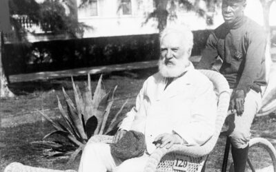
Alexander Graham Bell in Florida: Photo from the Last Year of His Life, 1922
Alexander Graham Bell in Wicker Wheel Chair, 1922 This 1922 photograph shows Alexander Graham Bell, the inventor, scientist, and patent holder of the first practical telephone, sitting in Florida during the final year of his life. He...

45 Patriotic Quotes from Presidents of the United States
Series of 45 patriotic quotes, one from each U.S. President.
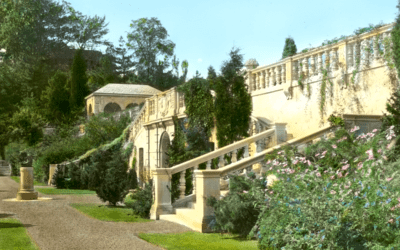
Killenworth Mansion, Russia’s Hidden Long Island Paradise
On the crest of a hill in Glen Cove, New York sits Killenworth, one of the country’s finest mansions

Top WWI fighter pilot explains why you should not fear death
“No one should fear death. I know, because I have come face to face with death several times”
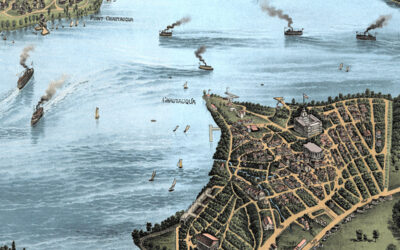
Restored Vintage Map of Chautauqua Lake from 1885
Vintage map of Lake Chautauqua, New York created in 1885 by the Matthews-Northrup Company of Buffalo, New York. The map shows a beautiful bird’s-eye view of Chautauqua Lake as it once was, with steamboats crossing the water, small lakefront communities along the shore, winding country roads, railroads, wooded hills, open farmland, hotels, docks, and summer places that shaped life around the lake in the late 1800s. This restored and colorized edition brings the historic view back to life while preserving the original linework, labels, and details of the 1885 map.
Restored Vintage Map of Orlando, Florida from 1884
This vintage map of Orlando, Florida was created in 1884 and published by J.J. Stoner of Madison, Wisconsin. The map shows a bird's eye view of Orlando as it once was, including street names, old landmarks, railroads, orange groves, lakes, hotels, churches,...
Vintage Map of Tallahassee, Florida 1885 | Restored & Colorized
Restored and colorized 1885 bird’s-eye view map of Tallahassee, Florida, showing the state capital as it once was. The map features the Capitol, University of Florida, State Seminary, Lincoln Academy, Leon Hotel, The Morgan, The Murat Place, churches, hotels, railroads, historic homes, businesses, and landmarks across Leon County.
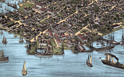
Restored Vintage Map of Key West, Florida from 1884
This vintage map of Key West, Florida was created in 1884 by J.J. Stoner of Madison, Wisconsin. The map shows a bird’s-eye view of Key West as it once was, including street names, old landmarks, wharves, sailing ships, churches, businesses, cigar factories, public...
Restored Vintage Map of Hoboken, New Jersey from 1881
This restored vintage map of Hoboken, New Jersey was originally created in 1881 and shows the city from a detailed bird’s-eye perspective. The map features Hoboken’s historic street grid, Hudson River waterfront, steamship piers, railroad yards, churches, factories, hotels, homes, civic buildings, and local landmarks. It has been carefully restored and colorized by KNOWOL to preserve the original linework while bringing the historic view of Hoboken to life.
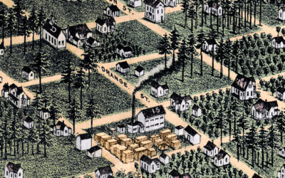
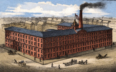
Restored Vintage Map of Bethel, Connecticut from 1879
This vintage map of Bethel, Connecticut was created in 1879 by O.H. Bailey, a prominent 19th century map maker. The map shows a bird’s eye view of Bethel as it once was, including street names, railroads, factories, churches, homes, and old landmarks. The map captures Bethel during the height of its 19th century growth, when the town was closely tied to the hat-making industry and the Danbury & Norwalk Railroad.
Restored Vintage Map of Pensacola, Florida from 1885
This vintage map of Pensacola, Florida was created in 1885 by Norris, Wellge & Co., with lithography by Beck & Pauli of Milwaukee, Wisconsin. The map shows a bird's eye view of Pensacola as it once was, including street names, old landmarks, railroads,...
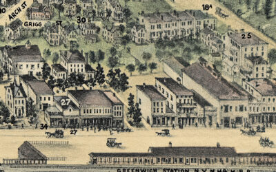
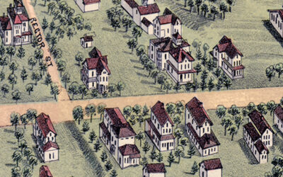
Vintage Map of Greenwich, Connecticut from 1904
Explore a restored 1904 bird’s-eye view map of Greenwich, Connecticut by O.H. Bailey, featuring historic streets, churches, schools, estates, railroads, and landmarks.
Who was Sigmund Spaeth, the American Musicologist?
Sigmund Spaeth (1885–1965) was an American musicologist, writer, and lecturer often referred to as "The Tune Detective." He was well known for his work in promoting music appreciation among the general public. Spaeth had a unique approach to explaining and analyzing...


