
The stony hill country above the old shore town, settled from 1716 by the grandsons of Killingworth's first planters, which kept the Killingworth name when the coast became Clinton in 1838.
Killingworth on the map
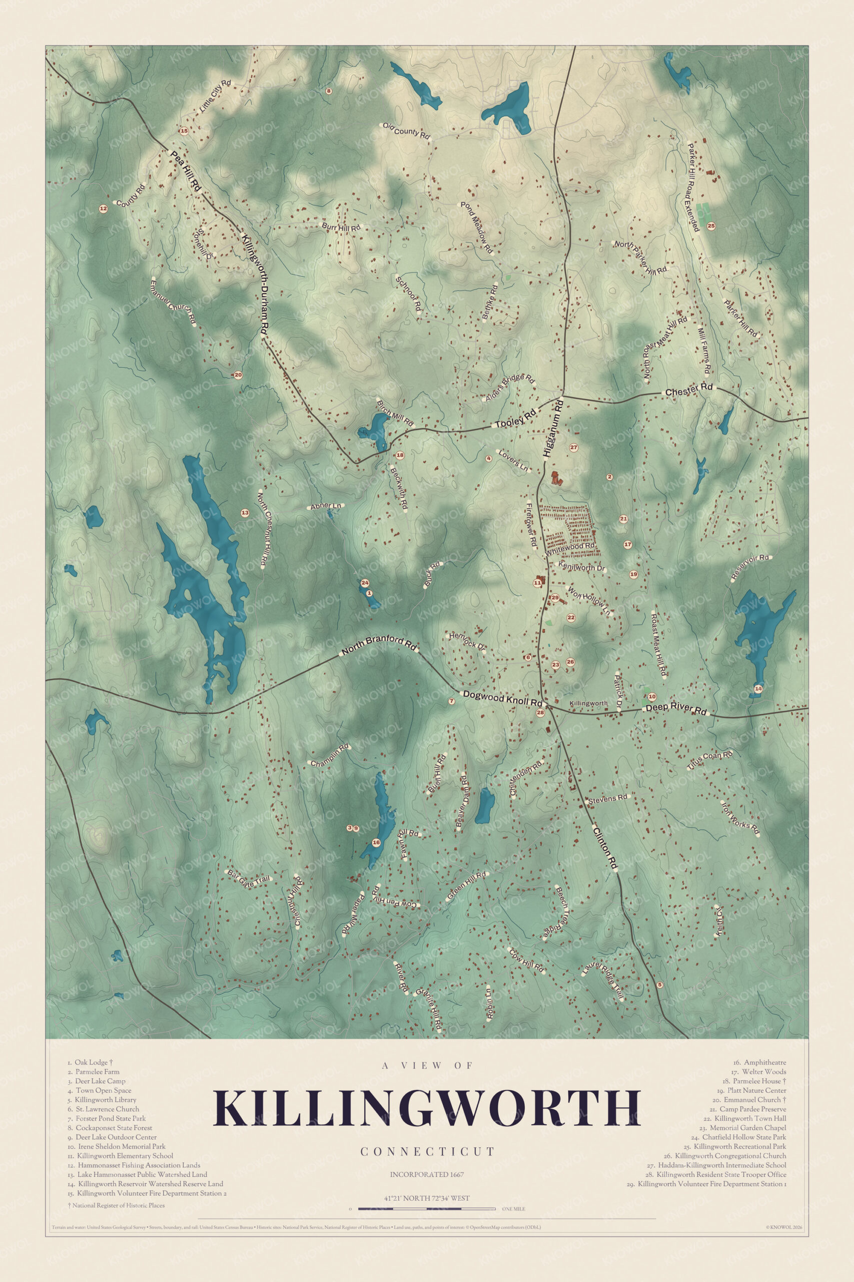
Click the map to look closer.
Killingworth today
By KNOWOL
Shaded hills from Buell Hill and Lord Corner to the deep valley of Chatfield Hollow and the woods of the Cockaponset, every road by name, and a guide of 29 numbered landmarks with the National Register sites marked.5
The story of Killingworth
The farmers on the hills
Today's Killingworth began as the back country of a shore town. The first planters settled along what's now Main Street in Clinton, and from 1716 their grandsons pushed north onto land their fathers had been granted. Isaac Kelsey settled on Cow Hill, Deacon Joseph Wilcox on Tower Hill, Daniel Buell on Roast Meat Hill and Theophilus Redfield on Chestnut Hill. An 1884 history pictures them walking three or four miles to church through snow and sleet, then sitting all day in a meetinghouse with no fire. The ground was rough and stony, better for grazing than for grain. The farmers got their own parish in 1735 and their own church in 1738, and when the shore half became Clinton in 1838, the north kept the old name.67891
The birds of Killingworth
Longfellow's poem "The Birds of Killingworth" tells of farmers who put a price on the heads of birds, and of the trouble that followed. A writer once asked Henry Hull, the town clerk, whether it really happened. Hull found no such vote in the town records, but he remembered something from when he was about fourteen. Every spring the men in the northern part of town picked two leaders and split into two sides, and the side that lost paid the bills. They went after hawks, owls, crows, blackbirds and squirrels, and some years each side brought them in by the bushel, until the birds grew scarce. The poet's brother, Samuel Longfellow, couldn't say the poet had ever heard of it. He'd found a clipping about a bird bounty debate in which a member from Killingworth spoke.10
Abner Lane's signals
Abner Lane was born in Killingworth in 1808, the seventh of a farmer's ten children. He went to school in the winters until he was sixteen, then took up shoemaking, and he worked at his bench with an open book in front of him. He taught himself natural philosophy, chemistry and higher mathematics. He made clothespins and then axe helves and pick handles, and invented a machine for turning them. He worked out a way of signaling between Killingworth Hill and Falkner's Island, 20 miles away, sent up a balloon, flew a kite on a fine wire, and showed a gyroscope to the Yale faculty. Neighbors came to his lectures. After he died in 1874, Hosmer Kelsey kept the axe handle business going.11
Through the years
25 moments from 1663 to today.
- 1663Planters begin the settlement at Hammonasset, on the shore in what's now Clinton. It becomes the old town of Killingworth.5
- 1667The town is named Kenilworth, after the English home of settler Edward Griswold. The spelling later drifts to Killingworth.5
- 1686The colony grants Kenilworth the lands north of its bounds, up to Coginchaug swamp.12
- 1708Killingworth hands the jurisdiction of that northern tract back to Durham for sixty acres.12
- 1716Farmers from the shore parish begin settling North Killingworth.2
- 1717About this year Theophilus Redfield settles on Chestnut Hill.13
- 1735North Killingworth becomes its own parish.8
- 1738On January 18, fifty members of the first church form the north parish church, with Rev. William Seward as pastor.8
- 1743The parish's first meetinghouse, 58 feet by 30, is finished enough to use.14
- 1773Daniel Jones comes from Saybrook and settles on Roast Meat Hill.15
- 1783Asahel Nettleton, later a famous revival preacher, is born in North Killingworth.16
- 1801Titus Coan, later a missionary in Hawaii, is born in Killingworth.17
- 1803The church that's now Emmanuel Church goes up near the Hammonasset River.18
- 1814A woolen factory is built on the Menunketesuck River.19
- 1816The Chester and North Killingworth Turnpike is chartered, seven miles from Chester Cove.20
- 1817North Killingworth gets a post office, and Union Church, now Emmanuel, is consecrated.2122
- 1820The parish builds a new Congregational meetinghouse.14
- 1838The shore half becomes the town of Clinton, and the north keeps the name Killingworth.19
- 1841A Methodist church is raised on land given by Philo Parmelee.23
- 1865A paper mill is built on the Hammonasset River off Green Hill Road.24
- 1880The Killingworth Agricultural Society is chartered and soon builds its own hall.25
- 1890sClark Coe builds the Killingworth Images, life-sized moving figures driven by a waterwheel, on his Green Hill Road farm.5
- 1934The Civilian Conservation Corps dams Chatfield Hollow Brook to make Schreeder Pond, and Bridge No. 1132 is built over the Hammonasset.326
- 1937The CCC builds Oak Lodge beside Schreeder Pond.27
- 2000The town buys Parmelee Farm, 132 acres on Route 81.5
Places to see
The numbers match the landmark guide printed on the 2026 map.
- 1Oak LodgeChatfield Hollow. CCC lodge of 1937 by Schreeder Pond.
- 2Parmelee FarmRoute 81 north. 132 acres the town bought in 2000.Visit their website
- 5Killingworth LibraryRoute 81. Run by the Killingworth Library Association.
- 7Forster Pond State ParkSouthwest of the center. Small state park near the center.
- 8Cockaponset State ForestNorth of town. Connecticut's second largest state forest.Visit their website
- 18Parmelee HouseBeckwith Road. Ezra Parmelee's house of about 1770.
- 20Emmanuel ChurchEmmanuel Church Road. Built 1803, renamed Emmanuel in 1869.
- 22Killingworth Town HallTown center. At the heart of the town center.
- 24Chatfield Hollow State ParkWest of the center. 412 acres in a glacial valley.Visit their website
- 26Killingworth Congregational ChurchTown center. Church of the old north parish.Visit their website
On the National Register
All 5 places in Killingworth on the National Register of Historic Places that still stand today, oldest first, and why each one matters.4
-
Parmelee House
Built about 1770 by Ezra Parmelee, a descendant of one of the area's first settlers, it seems to have started as a bank barn and was turned into a house in the late 1780s. Parmelee descendants owned it for most of the years until 1928.28
-
Emmanuel Church
Built by Episcopal families of North Bristol, now North Madison, and North Killingworth, it was called Union Church until it was renamed Emmanuel, "God is with us," in 1869. Rev. George B. Gilbert revived it after 1909, and his book Forty Years a Country Preacher topped the New York Times best seller list in 1939.18
-
Hammonasset Paper Mill Site
The remains of a mill that made strawboard, a material used for boxes, from 1865 until 1890. Parts of a stone dam, the stone mill foundation and the raceways survive on both banks of the river, on land trust trails.24
-
Bridge No. 1132
An open-spandrel concrete arch with a 100-foot main span over a steep wooded ravine, one of a small number of its kind in the state. The Highway Department praised it for its scenic setting when it was built.26
-
Oak Lodge
One of Connecticut's finest examples of Civilian Conservation Corps building, with a fieldstone chimney, a big stone fireplace and wrought iron hinges. It was listed with Schreeder Pond, which the CCC made in 1934, and the other CCC park buildings.27
In their words
“The north boundary of Killingworth was for many years "the wilderness," and not until these settlers had subdued the hills and built houses did the line become fixed where it now is.”
History of Middlesex County, 1884, on the first farmers of the north parish6
“Some years each side would bring them in by the bushel; it was followed up only a few years, for the birds began to grow scarce.”
Henry Hull, town clerk of Killingworth, on the spring bird hunts, in In olde Connecticut, 190610
“He possessed the rare gift of expounding the deepest scientific truths in simple language so as to make himself understood by the popular audience.”
History of Middlesex County, 1884, on Abner Lane11
Nearby towns
Sources
- Killingworth, Connecticut, Wikipedia
- A statistical account of the county of Middlesex, in Connecticut (1819), on the settlement of North Killingworth, Internet Archive
- Chatfield Hollow State Park, Wikipedia
- National Register of Historic Places listings in Middlesex County, Connecticut, Wikipedia
- Map of Killingworth, Connecticut in 2026, KNOWOL (USGS elevation, Census Bureau roads)
- History of Middlesex County, Connecticut (1884), on the present Killingworth, Internet Archive
- Connecticut historical collections, John Warner Barber (1837), Internet Archive
- A statistical account of the county of Middlesex, in Connecticut (1819), on the North Killingworth church, Internet Archive
- A history of Christ Episcopal Church in Guilford, Connecticut (1895), Internet Archive
- In olde Connecticut (1906), Killingworth and its birds, Internet Archive
- History of Middlesex County, Connecticut (1884), on Abner Lane, Internet Archive
- History of Durham, Connecticut, from the first grant of land in 1662 to 1866 (1866), Internet Archive
- Commemorative biographical record of New Haven County, Connecticut (1902), on Theophilus Redfield, Internet Archive
- History of Middlesex County, Connecticut (1884), on the Congregational church, Internet Archive
- Commemorative biographical record of Middlesex County, Connecticut (1903), on Daniel Jones, Internet Archive
- A memorial of the semi-centenary celebration of the founding of the Theological Institute of Connecticut (1884), Internet Archive
- History of Middlesex County, Connecticut (1884), on Titus Coan, Internet Archive
- Emmanuel Church (Killingworth, Connecticut), Wikipedia
- A statistical account of the county of Middlesex, in Connecticut (1819), on the forge and woolen factory, Internet Archive
- History of Middlesex County, Connecticut (1884), on the turnpikes, Internet Archive
- Historic towns of the Connecticut River valley (1906), Internet Archive
- History of Middlesex County, Connecticut (1884), on Emmanuel Church, Internet Archive
- History of Middlesex County, Connecticut (1884), on the Methodist church, Internet Archive
- Hammonasset Paper Mill Site, Wikipedia
- History of Middlesex County, Connecticut (1884), on the Killingworth Agricultural Society, Internet Archive
- Bridge No. 1132, Wikipedia
- Oak Lodge, Wikipedia
- Parmelee House (Killingworth, Connecticut), Wikipedia