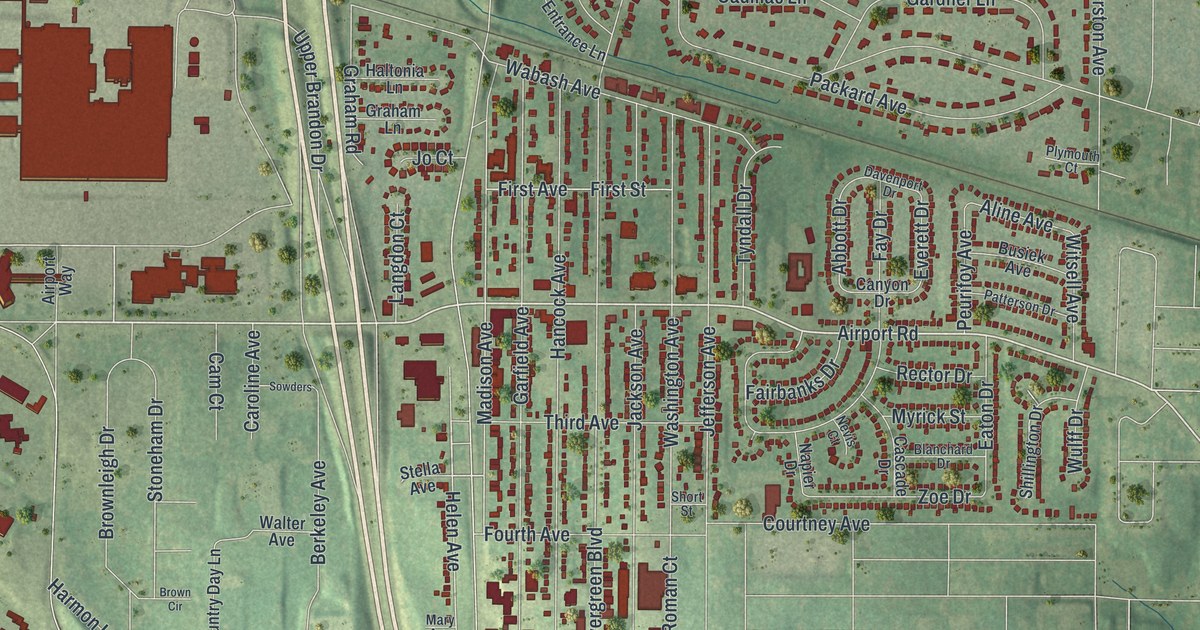
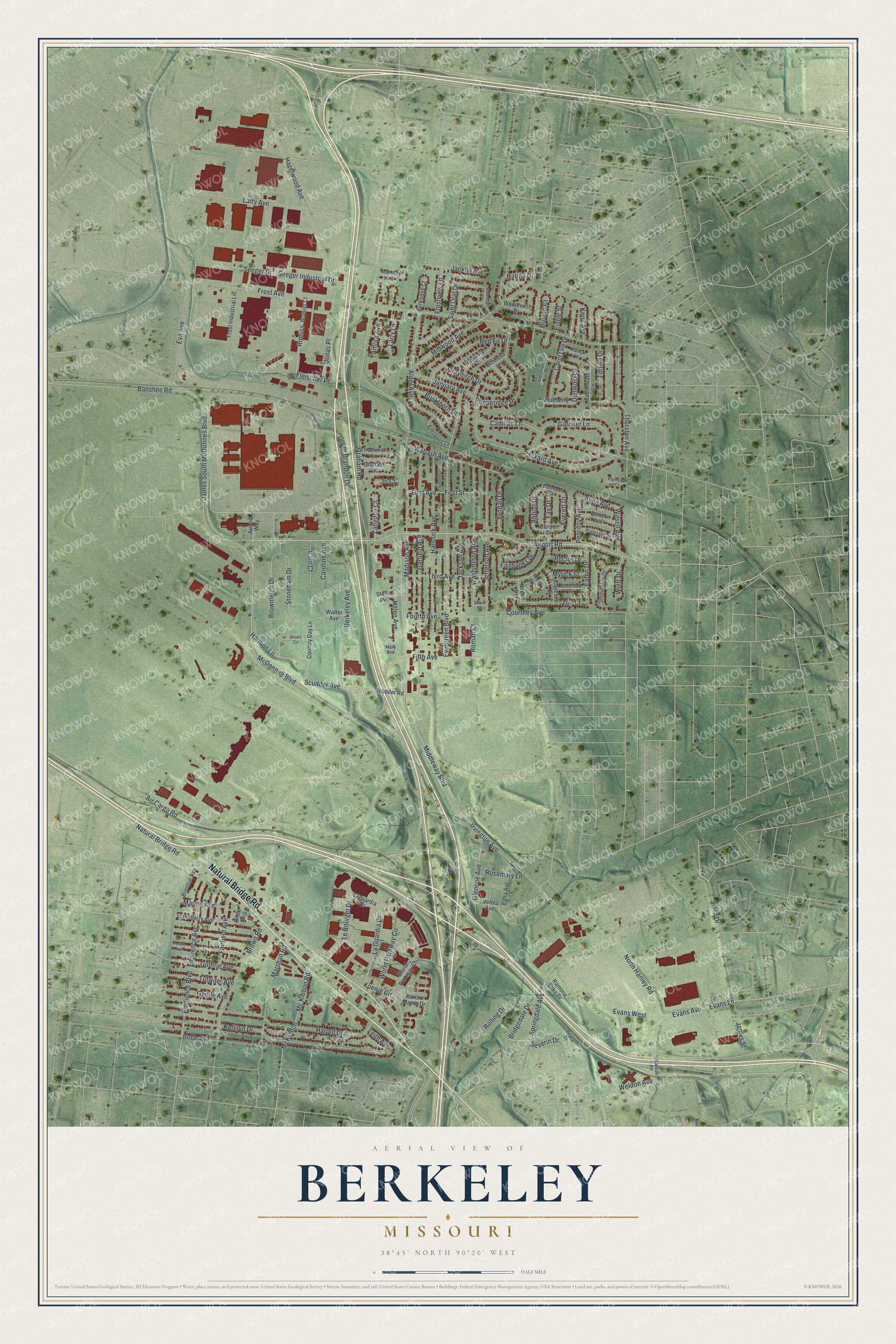
If you grew up in Berkeley or still have family near Natural Bridge Road, this map was made with you in mind. It's an aerial-style view with a vintage feel, made from modern data, of Berkeley in St. Louis County, Missouri. Green hills and low ground roll across the whole sheet. Thousands of small red shapes mark the buildings. You can pick out the curving blocks of houses, the larger buildings and the wide highways that cross the town.
Berkeley Was First Called Kinlock
On this map you'll find Natural Bridge Road, North Hanley Road, Airport Road, McDonnell Boulevard, Frost Avenue, Wabash Avenue, Jefferson Avenue, Washington Avenue, Berkeley Avenue, Courtney Avenue, Hazelwood Avenue, Scudder Avenue, Latty Avenue, Evergreen Boulevard, Weldon Avenue, and more. Each red shape is a building, so zoom in on the preview and look for yours.
This place once had another name. The State Historical Society of Missouri keeps an old file of place names, gathered from 1928 to 1945. It says the town was first known as Kinlock. Kinlock was a post office that opened in 1893. It sat on the Wabash Railroad, two miles west of Ferguson. The post office closed in 1928. The file lists where the name Kinlock came from as unsolved.
Wabash Avenue and the Old Rail Stop
Today you can still find the railroad's name on the map. Wabash Avenue is printed among the neighborhood streets, and it shares its name with that old line. Look for it next time you zoom in.
Natural Bridge Road and Home on Your Wall
Names on this map
These names are printed on this map.
Streets and roads: Natural Bridge Road, Airport Road, Helen Avenue, Madison Avenue, Scudder Avenue, Hern Drive, Marshall Road, North Hanley Road, Air Cargo Road, Koenig Circle, James South McDonnell Boulevard, McDonnell Boulevard.
More street names, A to Z
Abbott Drive, Airport Way, Alder Avenue, Aline Avenue, Amora Avenue, Banshee Road, Bayberry Drive, Berkeley Avenue, Berkridge Court, Biloxi Avenue, Bitteroot Lane, Blanchard Drive, Blueberry Lane, Bobb Avenue, Brenton Avenue, Bridgedale Drive, Brower Court, Brown Circle, Brownleigh Drive, Brown Road, Buckthorn Drive, Busiek Avenue, Cadillac Lane, Cam Court, Canyon Drive, Caroline Avenue, Carol Lee Drive, Carson Road, Cascade Drive, Country Day Lane, Courtney Avenue, Davenport Drive, Dunwold Drive, Eaton Drive, Eisele Street, Eltha Avenue, Eminence Avenue, Eminence Boulevard, Entrance Lane, Eva Avenue, Evans Avenue, Evans Lane, Evans West, Everett Drive, Evergreen Boulevard, Fairbanks Drive, Fairfield Avenue, Fay Drive, Fifth Avenue, First Avenue, First Street, Fleischer Place, Fourth Avenue, Frost Avenue, Frost Industrial Lane, Frostview Lane, Gardner Lane, Garfield Avenue, Gedde Avenue, Glencoe Avenue, Graham Lane, Graham Road, Graybirch Drive, Guthrie Avenue, Haltonia Lane, Hancock Avenue, Harmon Lane, Harold Drive, Hatina Drive, Hazelwood Avenue, Independence Lane, Irvington Avenue, Jacklin Avenue, Jackson Avenue, James Street, January Avenue, Jefferson Avenue, Jo Court, Jonas Place, Karole Manor Drive, Kathlyn Drive, Knoll Avenue, La Guardia Drive, Laguardia Drive, Langdon Court, Larry Lane, Latty Avenue, Le Bourget Drive, Leith Avenue, Macon Avenue, Marilyn Court, Martony Lane, Mary Avenue, McKibbon, Mc Kibbon Road, Middleway Boulevard, Midwood Avenue, Moran Drive, Myrick Street, Napier Drive, Nevis Court, Packard Avenue, Patterson Drive, Peace Drive, Pepperidge Drive, Peurifoy Avenue, Plymouth Court, Ramona Lake Drive, Rector Drive, Red Fir Drive, Rolling Drive, Roman Court, Romiss, Romiss Court, Rosemary Lane, Saint Olaf Drive, Sassenrath Lane, Scudder Road, Seeger Drive, Seeger Industrial Drive, Severin Drive, Shillington Drive, Short Street, Sowders, Springdale Avenue, Stansberry Avenue, Stella Avenue, Stoneham Drive, Third Avenue, Thurston Avenue, Torlina Drive, Trefore Avenue, Tutwiler Avenue, Tyndall Drive, Upper Brandon Drive, Velma Avenue, Wabash Avenue, Walter Avenue, Washington Avenue, Waterleigh Drive, Weldon Avenue, Witsell Avenue, Woodhurst Drive, World Parkway Circle, World Parkway Court, Wulff Drive, Zoe Drive.
Created by KNOWOL in 2026. The print shows the land in soft greens with shaded hills, thin pale roads and deep red buildings, framed by a cream border. The title panel reads "Aerial View of Berkeley, Missouri" with the line 38°45' North 90°20' West.
It fits well in a living room, a hallway or a home office. It's a good gift for someone who grew up off Natural Bridge Road and moved away, or for a family that's lived here for years. Open the preview and find your street. See sizes and frames for the Berkeley map.