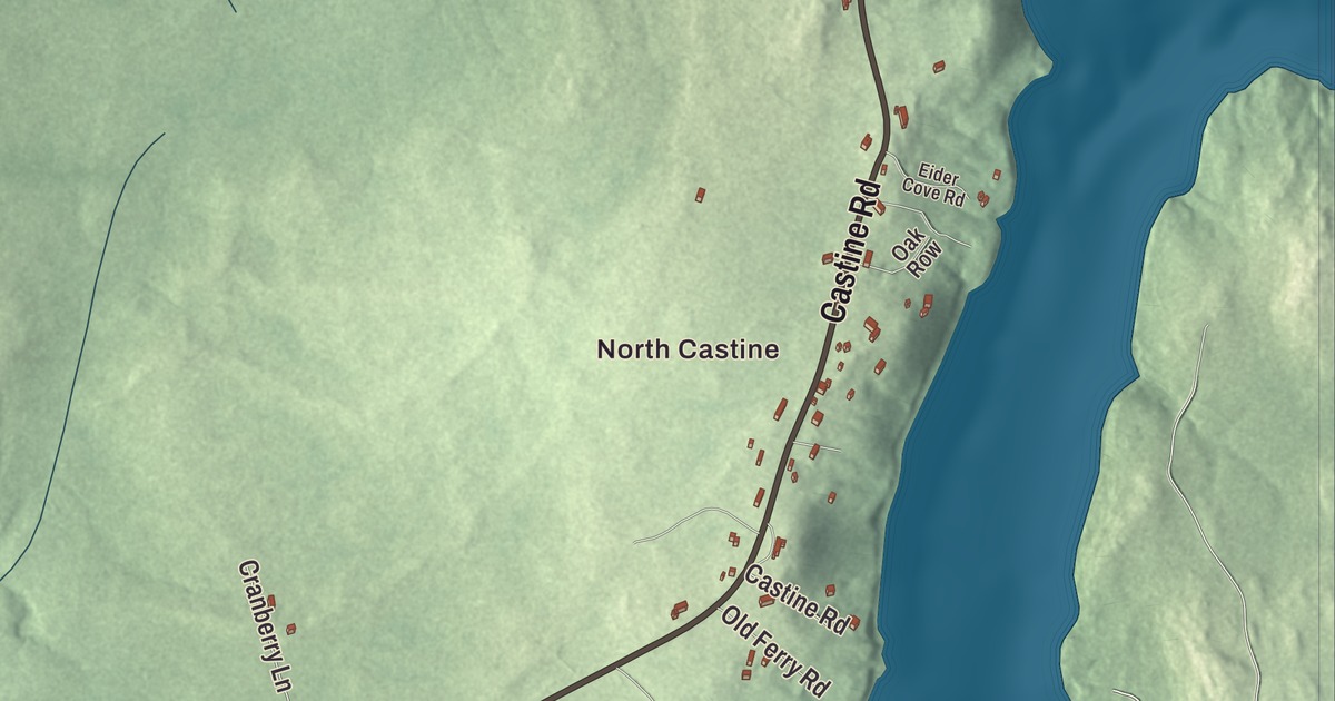
Battle Avenue, Water Street and The Shore Road are printed on this map of Castine, Maine, and so is Fort George. North Castine and West Castine are printed too, with Castine Road, Shore Road, Wilson Point Road, the Penobscot River and Bog Brook. Click here to purchase a print of this map for your wall.
Castine is a town in Hancock County, with 1,320 people at the 2020 census.
KNOWOL made this map in 2026 from public survey data and styled it after an old atlas. The peninsula is shaded from United States Geological Survey elevation data, and the roads and town line come from the Census Bureau. The bureau counts 20.01 square miles in Castine, 12.23 of them water. The town sits on a peninsula in Penobscot Bay, and the Bagaduce River estuary drains it.
Majabigwaduce
The Tarrantine Abenaki called this place Majabigwaduce. In the winter of 1613 the Acadian leader Claude de Saint-Étienne de la Tour set up a small trading post here to trade with the Tarrantine people, now called the Penobscots, and the town’s page counts Castine as one of the oldest towns in New England, seven years older than the Plymouth Colony. The French, the Dutch and England’s Plymouth Colony all held it at one time or another, and Castine still calls itself the “battle line of four nations.” The site of the French fort and trading post, Pentagoet, is now a National Historic Landmark district and a public park.
The town is named for Jean-Vincent d’Abbadie de Saint-Castin, the French baron sent to command Pentagoet in 1667. He married the daughter of the Abenaki sachem Modockawando, and Castine became a force in colonial trade and diplomacy. Massachusetts incorporated the township as the Town of Penobscot in 1787, and on February 10, 1796, it was divided into the towns of Castine and Penobscot. Castine held its first town meeting on April 4, 1796.
Fort George and Battle Avenue
Fort George is printed on the map, and so is Battle Avenue. The fort’s National Register listing gives its address as Wadsworth Street off Battle Avenue. British troops under General Francis McLean sailed into the harbor in 1779 and began building the fort on one of the highest points of the peninsula. Massachusetts answered with the Penobscot Expedition, a fleet and a land force of about 1,200 men, with Colonel Paul Revere in charge of the ordnance, but the attack failed and the British held Castine to the end of the war.
The British came back in the War of 1812 and occupied the village from 1814 to April 1815. When they left they took the customs duties they had collected at Castine, and that money, called the Castine Fund, was used to establish Dalhousie University in Halifax, Nova Scotia. What’s left of Fort George today is mostly its earthworks, in a park owned by the state and kept by the town. Two American officers held there, Peleg Wadsworth and Benjamin Burton, escaped on June 15, 1781, by cutting a hole in the roof of their jail under cover of a heavy rainstorm.
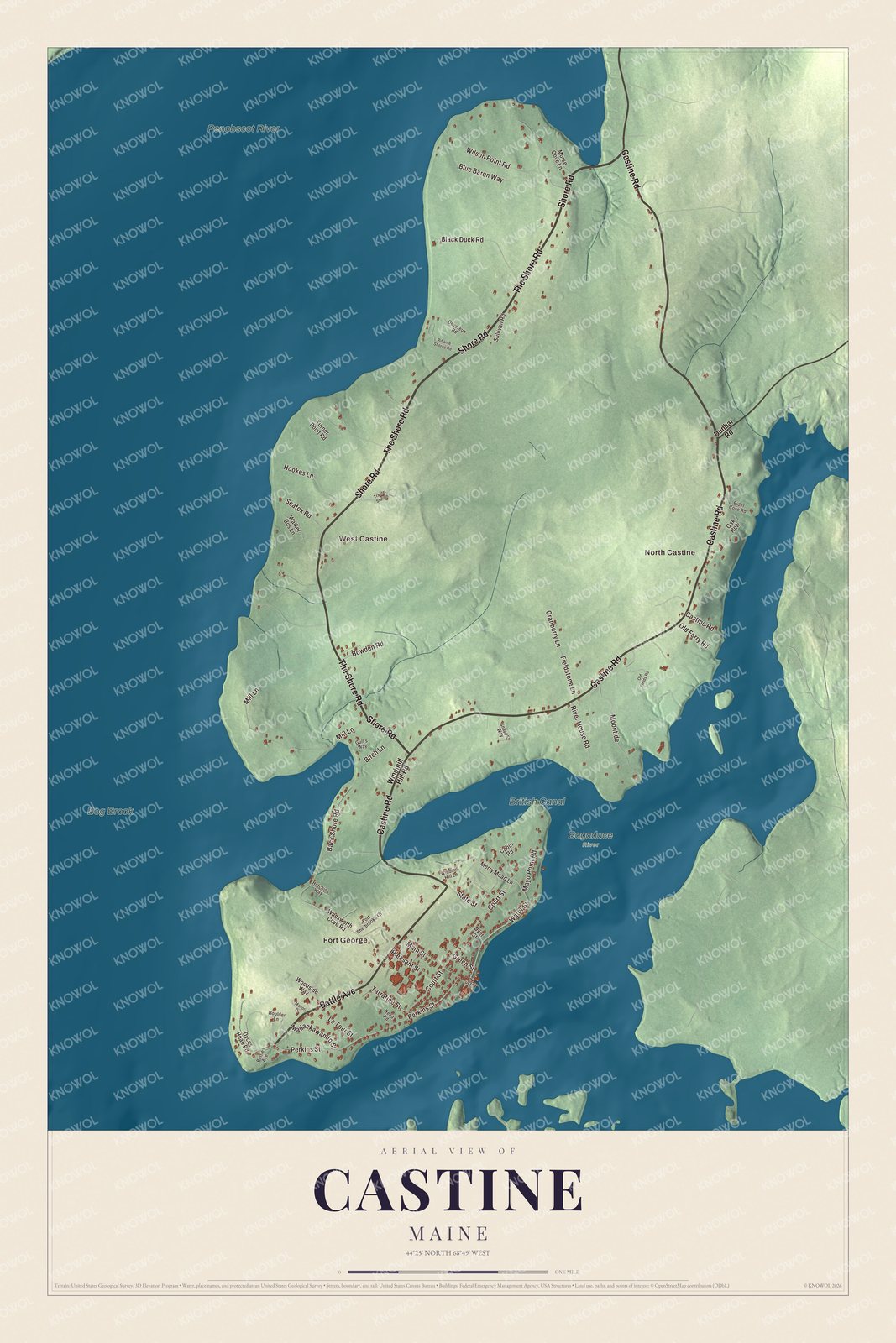
Click to explore a larger preview. The digital watermark does not appear on printed maps.
See it on a wall
The Castine map as a framed print. Swipe for more.


The village by the harbor
After the War of 1812 Castine prospered as a shipbuilding and coastal trading town, and many of the Federal and Greek Revival houses on its streets date from those years. The Castine Historic District covers the whole southern tip of the peninsula, and at its southwestern point stands Dice Head Light, built in 1829. The town’s post office is in one of the oldest post office buildings in continuous operation in the United States. The building went up in 1817, and the government began leasing it in 1833.
The John Perkins House, built in 1765 on Court Street, is the only known house in Castine older than the Revolution. British troops occupied it in both wars, and the Wilson Museum saved it, taking it apart and putting it back together on Perkins Street in 1968 and 1969. The museum itself grew from the collections of the geologist Dr. John Howard Wilson, whose mother gave the land for it in 1921.
Maine Maritime Academy was established in 1941 on the campus of the Eastern State Normal School, which had been in Castine since 1867, and it trains officers and engineers for the Merchant Marine. The academy owns the schooner Bowdoin, built in 1921 and described as the only American schooner built specifically for Arctic exploration. Harriet Beecher Stowe stayed at the Cate House at Court and Pleasant streets. Noah Brooks, born in Castine, became a close friend of Abraham Lincoln and signed his Washington dispatches “Castine.” Abraham Niles, born and raised here, became an abolitionist in Portland and helped found the Abyssinian Meeting House, one of the oldest Black churches in the United States.
Up the peninsula
The Shore Road is printed on the map, and so are Castine Road and West Castine. State Route 166 begins at Battle Avenue near the academy, follows Castine Road out of the village, and turns northwest along The Shore Road through West Castine. Its sister route, 166A, runs up the Bagaduce side through North Castine. Along Route 166 just north of the neck, the Off-the-Neck Historic District keeps eleven houses built between about 1765 and 1830, and the canal British troops dug across the neck in 1779 marks its southern edge. North Castine is printed on the map as well, with Water Street, Shore Road, Wilson Point Road, the Penobscot River and Bog Brook.
This Castine map makes a fine addition to an office, library or den, and it can help teach children the geography and history of the area. It’s made for everyone who calls Castine home, from Battle Avenue to North Castine, as it looks today. Zoom in on the preview above to explore the details, then click here to get your copy of the Castine, Maine map.

Sources
- Castine, Maine, Wikipedia
- Pentagoet Archeological District, Wikipedia
- Fort George (Castine, Maine), Wikipedia
- National Register of Historic Places listings in Hancock County, Maine, Wikipedia
- Castine Historic District, Wikipedia
- John Perkins House (Castine, Maine), Wikipedia
- Wilson Museum, Wikipedia
- Maine Maritime Academy, Wikipedia
- Bowdoin (Arctic schooner), Wikipedia
- Cate House (Castine, Maine), Wikipedia
- Noah Brooks, Wikipedia
- Abraham Niles, Wikipedia
- Maine State Route 166, Wikipedia
- Off-the-Neck Historic District, Wikipedia