
A hill town at the foot of the Berkshires, once the West Britain parish of Bristol, where Seventh-Day Baptists from Rhode Island built the first church, Whigville made clocks and knife handles, and a tavern with a ballroom still faces the green.
Then and now
The same town 157 years apart. Click either map to look closer.
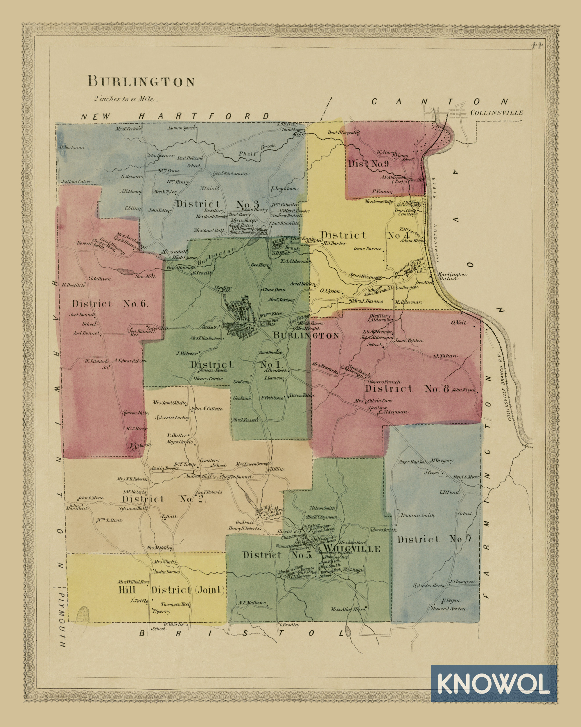
The landowners map
By Baker & Tilden
Every plot in town is marked with the name of the family living there in 1869, along with the Whigville Machine Shop, the Barnes and Alderman distilleries, Ford Hardware, a shingle mill, Burlington Station and Burlington Brook.5
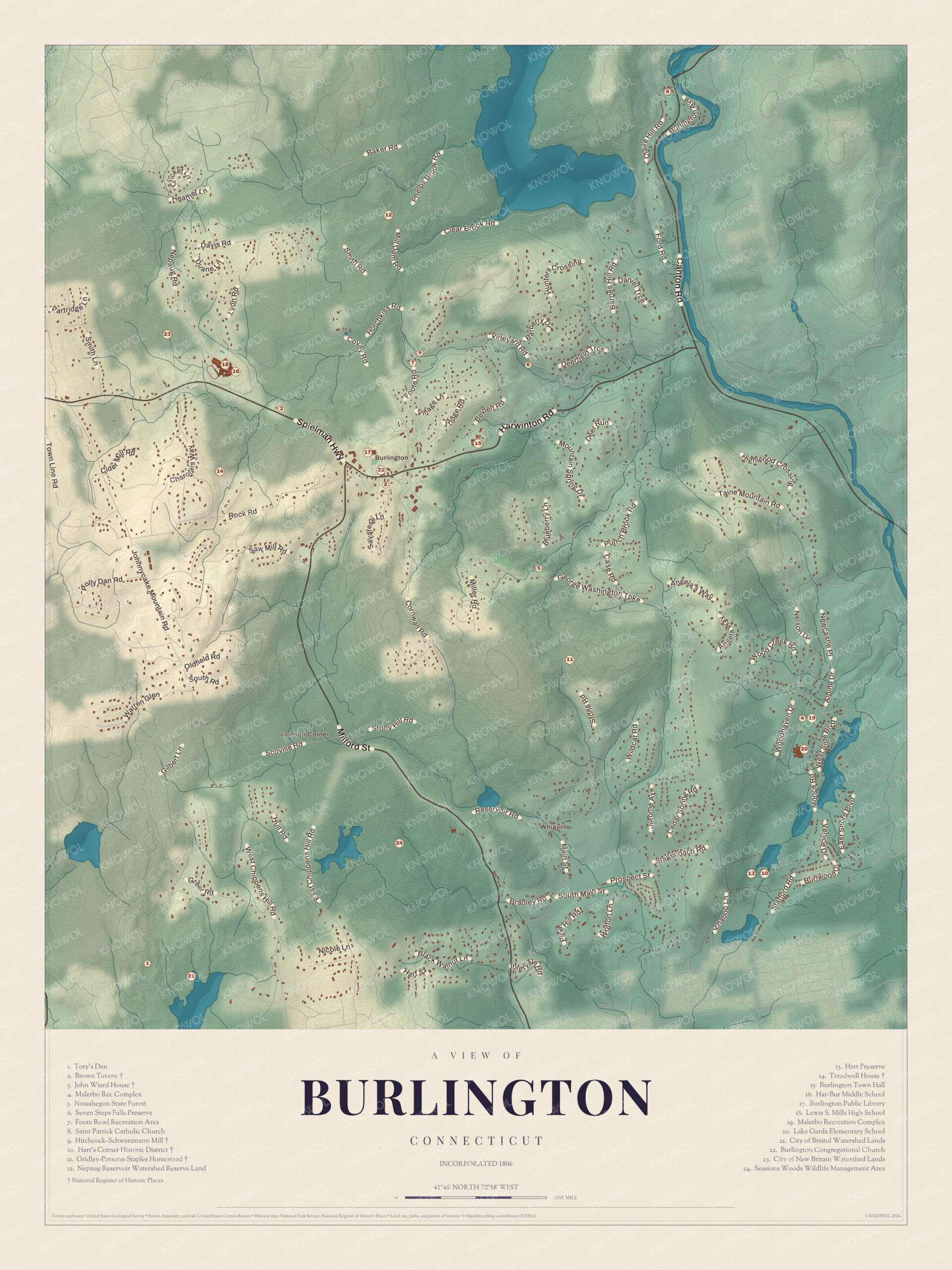
Burlington today
By KNOWOL
Shaded hills up to Johnnycake Mountain, Lake Garda, the Nepaug Reservoir and the Farmington River, every street with Whigville printed by name, and a guide of 24 numbered landmarks with the National Register sites marked.6
The story of Burlington
The Sabbath-keepers from Westerly
Burlington's first congregation wasn't the Congregational church. About twenty families came here from Westerly, Rhode Island, and on September 18, 1780, they organized a Seventh-Day Baptist church of nineteen members. Their settlement and meetinghouse stood about two miles north of today's town center. An 1886 county history calls them exemplary and industrious people who had much influence in the town's early affairs. Over the years many of the leading families moved on to New York State and joined churches of their own faith there, and after forty or fifty years the little church was gone. Their houses outlasted them. The town still has a Seventh Day Baptist Cemetery, also called the Green Lady Cemetery.31
Clock shops and Skibbereen
Whigville, in the southeast part of town, was a busy little shop village. A 1907 history of Bristol calls it a clock-making village. Stever and Bryant built a big clock shop there about 1845 and failed in a short time, and the building became the D. E. Peck turning works. In 1866 William Clayton, from Sheffield, England, set up in part of it, making table knife handles of wood, bone and ivory for blades shipped from England. Nearby, Irish families who worked the copper mines across the Bristol line lived in a row of low white cottages in Burlington. They named the place Skibbereen, after the port in County Cork. By 1907 nothing was left of it but open cellars.78910
The tavern on the green
Burlington Center grew up around a small triangular green. About 1810 the merchant Giles Griswold built a Federal-style house at its western end, with a Palladian window over the front door, and for the next 164 years it served as a home, a public house and an inn. Upstairs, a ballroom with a barrel-vaulted ceiling runs the whole width of the front. Old books called it the Old Brown Inn, though no record shows anyone named Brown ever owned it. Across the green stands a house built about the same time for Governor John Treadwell, who apparently never lived in it. The town bought the tavern in 1974, and local preservationists saved the Treadwell House from demolition.111213
Through the years
23 moments from 1740 to today.
- 1740Between now and 1755 the first permanent settlers come into Farmington West Woods, among them the Pettibones in the north and the Strongs in the east.2
- 1750Settlement of the West Woods begins in earnest about this year.2
- 1754John Wiard buys the land where his house still stands on Spielman Highway.14
- 1774The General Court sets up the church society of West Britain.2
- 1780Families from Westerly, Rhode Island, organize a Seventh-Day Baptist church of nineteen members, the first in town.3
- 1780Dr. Peres Mann of Shrewsbury, Massachusetts, the first doctor, settles in West Britain about this year.15
- 1783The Congregational Church is formed with twenty-six members.16
- 1785West Britain becomes part of the new town of Bristol.1
- 1806Burlington becomes a town, and Abraham Pettibone runs its first town meeting on June 16.2
- 1808The new Congregational meetinghouse is dedicated on Christmas Day.16
- 1810Giles Griswold builds the house on the green that becomes the Brown Tavern, about this year.11
- 1814The Methodists build their meetinghouse in the south part of town.16
- 1829The Farmington Canal opens, and many of the town's small industries close or move away.1
- 1844Every family but one in Poverty Hollow goes to a Henry Clay rally in Hartford, and the place becomes Whigville.10
- 1845Stever and Bryant build a large clock shop in Whigville, about this year.7
- 1866William Clayton of Sheffield, England, starts making knife handles of wood, bone and ivory in Whigville.8
- 1869Baker and Tilden publish their landowners map of Burlington.5
- 1880The census counts 1,224 people, most of them farmers.17
- 1882Charles C. McAleer, born in County Fermanagh, becomes the first Irishman elected to the Legislature from Burlington.18
- 1886Whigville Grange is organized on June 2.19
- 1895A monument is set on the grave of Katherine Gaylord, a survivor of the Wyoming Massacre, in the old Burlington cemetery.20
- 1948Burlington Consolidated School opens, replacing the old district schoolhouses. It's now the town hall.1
- 1974The town buys the Brown Tavern.11
Places to see
The numbers match the landmark guide printed on the 2026 map.
- 1Tory's DenSouthwest Burlington. Out in the southwest woods.
- 2Brown TavernThe town green. Griswold's inn with an upstairs ballroom.
- 3John Wiard HouseSpielman Highway. Early settler's house of about 1754.
- 5Nassahegon State ForestEast of the center. State forest just east of town.
- 6Seven Steps Falls PreserveNorth Burlington. Falls preserve in the north.
- 10Hart's Corner Historic DistrictMonce and Stafford Roads. Three farmsteads from the 1790s on.
- 14Treadwell HouseSpielman Highway. Built about 1810 for Governor Treadwell.
- 15Burlington Town HallBurlington Center. The old Consolidated School of 1948.
- 22Burlington Congregational ChurchBurlington Center. The church gathered in 1783.Visit their website
- 24Sessions Woods Wildlife Management AreaSouth Burlington. State wildlife land to the south.Visit their website
On the National Register
All 4 places in Burlington on the National Register of Historic Places that still stand today, oldest first, and why each one matters.4
-
John Wiard House
John Wiard, one of the first English settlers in what became Burlington, bought this land in 1754 and built the house soon after. It keeps much of its original woodwork, fireplace surrounds and hardware.14
-
Hart's Corner Historic District
Three well-kept farmsteads at one crossroads, from Israel Barnes's Cape of before 1795 to George Washington Hart's Italianate farmhouse, show a century of farming in southeastern Burlington.21
-
Brown Tavern
A fine Federal house built for the merchant Giles Griswold, with a Palladian window over its elaborate doorway. Later owners ran a tavern here, and the town bought it in 1974. The local historical society now looks after it.11
-
Treadwell House
Built for John Treadwell while he was Governor of Connecticut, though he seems never to have lived here. Its Greek Revival touches are an early use of that style, and preservationists saved it from demolition in the late 1970s.13
In their words
“The inhabitants are generally engaged in agricultural pursuits, and are intelligent, industrious, thriving, and happy, in their quiet homes.”
The memorial history of Hartford County, 188617
“It was named from the southern port Skibbereen of County Cork, Ireland, which was probably the last town in the loved home country on which their eyes rested.”
Bristol, Connecticut, 1907, on the Irish miners' village in Burlington9
“They were exemplary and industrious people, ardently attached to their faith.”
The memorial history of Hartford County, 1886, on the Seventh-Day Baptists3
Nearby towns
Sources
- Burlington, Connecticut, Wikipedia
- The memorial history of Hartford County, Connecticut, 1633-1884 (1886), on the settlement of Burlington, Internet Archive
- The memorial history of Hartford County, Connecticut, 1633-1884 (1886), on the Seventh-Day Baptists, Internet Archive
- National Register of Historic Places listings in Hartford County, Connecticut, Wikipedia
- Historic landowners map of Burlington, CT from 1869, restored by KNOWOL
- Map of Burlington, Connecticut in 2026, KNOWOL (USGS elevation, Census Bureau roads)
- Bristol, Connecticut: in the olden time New Cambridge (1907), on Whigville's clock shops, Internet Archive
- Bristol, Connecticut: in the olden time New Cambridge (1907), on Clayton Brothers, Internet Archive
- Bristol, Connecticut: in the olden time New Cambridge (1907), on Skibbereen, Internet Archive
- The Village of Whigville, Burlington Historical Society
- Brown Tavern, Wikipedia
- The Tavern, Burlington Historical Society
- Treadwell House, Wikipedia
- John Wiard House, Wikipedia
- The memorial history of Hartford County, Connecticut, 1633-1884 (1886), on Burlington's people, Internet Archive
- The memorial history of Hartford County, Connecticut, 1633-1884 (1886), on Burlington's churches, Internet Archive
- The memorial history of Hartford County, Connecticut, 1633-1884 (1886), on the town in 1880, Internet Archive
- Evening post annual, biographical sketches of the General Assembly of Connecticut (1882), on Charles C. McAleer, Internet Archive
- Bristol, Connecticut: in the olden time New Cambridge (1907), on Whigville Grange, Internet Archive
- The Connecticut quarterly (1896), on the Katherine Gaylord monument, Internet Archive
- Hart's Corner Historic District, Wikipedia