
A farm town on the old Coginchaug swamp, where eight people formed a Book Company in 1733, shoemakers once filled Main Street, and the Durham Fair has been held since 1916.
Durham on the map
Click the map to look closer.
Durham today
By KNOWOL
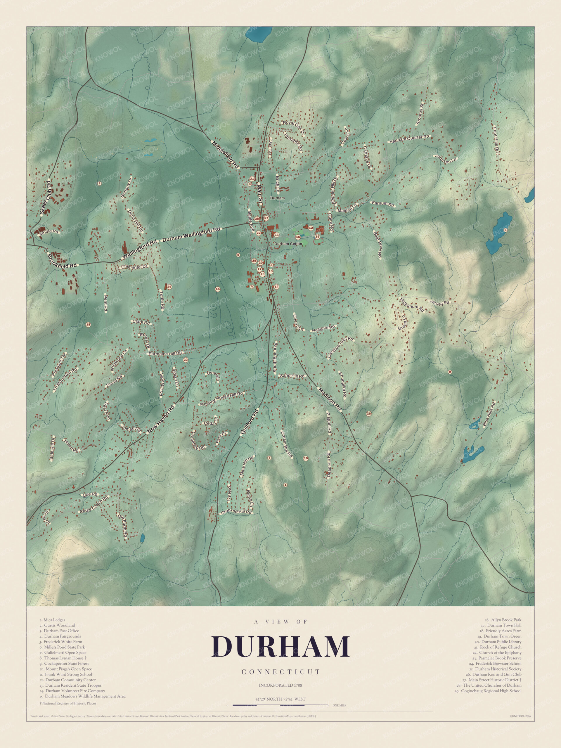
Shaded hills from the trap rock ridges in the west across to Durham Center, every street from Main Street to Cream Pot Road, and a guide of 29 numbered landmarks with the National Register sites marked.6
The story of Durham
Coginchaug becomes Durham
Before it was Durham, this was Coginchaug, the long swamp, a hunting ground Native people came to often. The colony had handed out farms here as rewards, and many owners never lived on them. In May 1704 the farm owners asked the Assembly to encourage a settlement and gave up a quarter of their land for new settlers' lots. By May 1708, when the town got its privileges, 34 grown men lived here. Col. James Wadsworth was the first captain, the first justice of the peace and the first town clerk. Haddam Quarter joined the town in 1773. Later a party of Merwins went west and founded a Durham in Greene County, New York, named after the village they came from.67289
North and south of Mill Bridge
Allyn's Brook splits Durham in two, and for years the people north and south of Mill Bridge didn't agree about much. When a new church was planned in 1835, both ends fought for the site. The town finally let it go up on the old burying ground, which left the open green that an 1884 history called the chief ornament of the town. That church burned in November 1844, and the fight started again, fiercer than before. In 1846 the society voted 37 to 13 to build on Dennis Camp's land on Main Street, and in April 1847 a second Congregational church was formed with 62 members. Years later, money from selling the last church on the meeting-house green helped build Durham's first brick building, its library.101112
Shoes, tin and the stage road
In the early 1800s Main Street was a street of shoemakers. Four tanneries supplied the leather, the finished shoes went to the Southern States, and an 1884 history says the shoe shops once employed between 300 and 400 men. Flax grew everywhere, cloth was made in every house, and potash was made at the hill still called Potash Hill. Durham sat halfway between New Haven and Hartford, and John Swathel turned a building at the north end of Main Street into the stop for the stage line, back when six stages a day came through. Later the Merriam Manufacturing Company made tinware here, and boys as young as eleven worked in its tin shop.13414151617
Through the years
24 moments from 1662 to today.
- 1662Settlers buy tracts of land at Coginchaug from the Mattabesset people.1
- 1704The owners of farms at Coginchaug ask the Assembly to encourage a settlement, and give up a quarter of their land for new settlers.2
- 1704Thomas Miller dams the pond that's now Millers Pond to store water for his gristmill.18
- 1708Durham is incorporated, with 34 grown men living in town.2
- 1733On October 30, eight people form the Book Company of Durham to buy books together.3
- 1737Families on the west side of Coginchaug swamp are allowed a school of their own.19
- 1756Elizur Goodrich accepts the call to be Durham's minister.20
- 1761Moses Austin, father of Stephen F. Austin, is born in Durham.1
- 1773Haddam Quarter is annexed to Durham.2
- 1774Thomas Lyman IV builds his hip-roofed house on Middlefield Road, about this year.21
- 1777Ralph Isaacs, judged hostile to the American cause, is confined within set bounds in Durham and kept from selling rum.22
- 1802An Episcopal parish is organized and meets in the Center District schoolhouse.23
- 1835North and south ends fight over the site of a new church, which goes up on the old burying ground.10
- 1844The church burns in November, and the fight over the site starts again.10
- 1847A second Congregational church is organized in April with 62 members.10
- 1854The Durham Lyceum is organized, and its library grows past 500 volumes.3
- 1867The Merriam Manufacturing Company of Durham is listed among the region's tinware makers.16
- 1878The Wallingford storm drops a sixteen-foot board into Walter Hart's freshly unroofed house in Durham.24
- 1886Henry G. Newton, declared elected by one vote, argues a miscount and unseats himself.25
- 1899Durham celebrates its bicentennial on July 4.25
- 1901The library on Main Street is built, the first brick building in Durham.12
- 1916The first Durham Fair is held.26
- 1975The Thomas Lyman House is listed on the National Register.21
- 1986The Main Street Historic District is listed on the National Register.13
Places to see
The numbers match the landmark guide printed on the 2026 map.
- 4Durham FairgroundsMiddle of town. Home of the fair since 1916.
- 6Millers Pond State ParkEast, into Haddam. Spring-fed pond dammed in 1704.Visit their website
- 8Thomas Lyman House105 Middlefield Road. Hip-roofed house of about 1774.
- 17Durham Town HallDurham Center. A Greek Revival church from 1849.
- 19Durham Town GreenDurham Center. The open green in the center.
- 20Durham Public LibraryDurham Center. A library town since 1733.Visit their website
- 22Church of the EpiphanyNorth end of town. Episcopal parish organized in 1802.
- 25Durham Historical SocietyDurham Center. Keeper of the town's history.
- 27Main Street Historic DistrictDurham Center. 112 historic properties on 160 acres.
- 28The United Churches of DurhamDurham Center. Church in the town center.
On the National Register
All 2 places in Durham on the National Register of Historic Places that still stand today, oldest first, and why each one matters.5
-
Main Street Historic District
The civic, commercial and residential center of Durham, laid out along a ridge of high ground between the swamps on the road between Hartford and New Haven. Its 112 historic buildings run from colonial houses to Federal and Victorian ones, with homes built for mill workers, the 1849 church that became the town hall, an early tavern and the 1901 library.13
-
Thomas Lyman House
A well-kept late Colonial house, unusual around here for its hip roof, built by Thomas Lyman IV on land his father bought in 1709. Lyman fought in the Revolution and is said to have welcomed Lafayette here several times.21
In their words
“Beautiful is the village of Durham and its long, broad streets, studded with neat habitations, the abode of peace and virtue, of contentment and religion.”
An early Durham historian, quoted in Chapter sketches, Connecticut Daughters of the American Revolution, 190115
“This left a fine open green surrounded by houses. It is the chief ornament of the town.”
History of Middlesex County, 188410
“Durham made nearly everything that was used there.”
Commemorative biographical record of Middlesex County, 1903, on the days of Miles Merwin9
Nearby towns
Sources
- Durham, Connecticut, Wikipedia
- Connecticut historical collections, John Warner Barber (1836), on Durham's settlement, Internet Archive
- History of Middlesex County, Connecticut (1884), on Durham's libraries, Internet Archive
- History of Middlesex County, Connecticut (1884), on Durham's trades, Internet Archive
- National Register of Historic Places listings in Middlesex County, Connecticut, Wikipedia
- Map of Durham, Connecticut in 2026, KNOWOL (USGS elevation, Census Bureau roads)
- History of the town of Plymouth, Connecticut (1895), on the Sutliffs and Durham's farm grants, Internet Archive
- A catalogue of the names of the first Puritan settlers of the colony of Connecticut (1846), on Col. James Wadsworth, Internet Archive
- Commemorative biographical record of Middlesex County, Connecticut (1903), on Miles Merwin, Internet Archive
- History of Middlesex County, Connecticut (1884), on the north and south churches, Internet Archive
- Commemorative biographical record of Middlesex County, Connecticut (1903), on the church vote of 1846, Internet Archive
- Commemorative biographical record of Middlesex County, Connecticut (1903), on the Memorial Library, Internet Archive
- Main Street Historic District (Durham, Connecticut), Wikipedia
- Commemorative biographical record of Middlesex County, Connecticut (1903), on John Swathel, Internet Archive
- Chapter sketches, Connecticut Daughters of the American Revolution (1901), on Durham, Internet Archive
- Merwin's Connecticut River business directory for 1867/8 (1867), Internet Archive
- Commemorative biographical record of Middlesex County, Connecticut (1903), on the Merriam tin shop, Internet Archive
- Millers Pond State Park, Wikipedia
- A statistical account of the county of Middlesex, in Connecticut (1819), on Durham's schools, Internet Archive
- History of Durham, Connecticut, from the first grant of land in 1662 to 1866 (1866), on the call of Elizur Goodrich, Internet Archive
- Thomas Lyman House, Wikipedia
- A historical collection of the part sustained by Connecticut during the war of the revolution (1842), on Ralph Isaacs, Internet Archive
- History of Middlesex County, Connecticut (1884), on the Church of the Epiphany, Internet Archive
- History of the Wallingford disaster (1878), Internet Archive
- Genealogical and family history of the state of Connecticut (1911), on Henry Gleason Newton, Internet Archive
- Durham Fair, Wikipedia