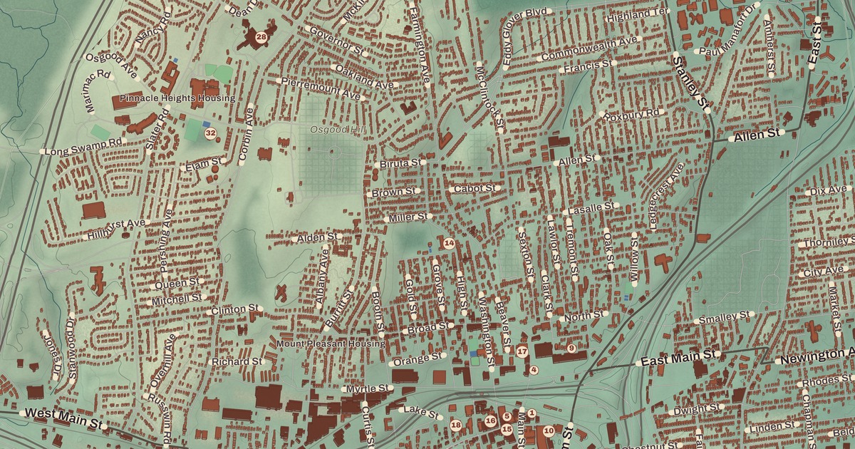
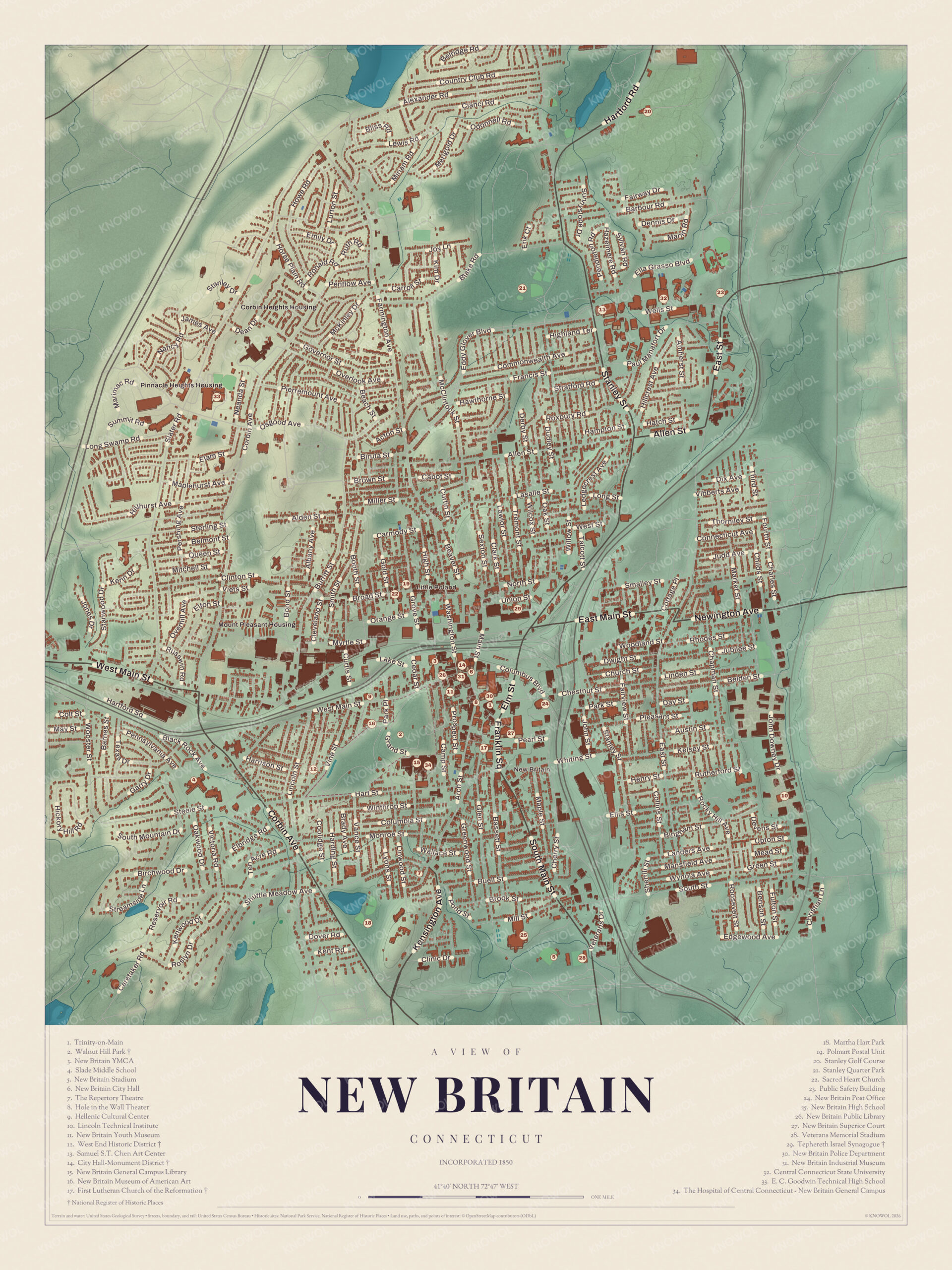
If you grew up in New Britain, or you’ve ever walked up through Walnut Hill Park to the museum, you’ll find your city on this map just as it stands in 2026. Look for your road. Wells Street, Clinton Street, Newington Avenue, Pearl Street, Columbia Street, Monroe Street, Allen Street, Smalley Street, Union Street and Main Street are all printed by name, along with many more.
New Britain is in Hartford County, about nine miles southwest of Hartford.
KNOWOL made this map in 2026 from public survey data, and gave it the look of an old atlas. The gentle, rolling hills, from Walnut Hill west of downtown to the north end, come from United States Geological Survey elevation data. The streets and the city line come from the Census Bureau, right down to roads like Elm Street. New Britain, Little Poland, Corbin Heights Housing, Pinnacle Heights Housing and Mount Pleasant Housing are printed by name. A guide of 34 numbered landmarks runs along the bottom, with the National Register sites marked, and we checked those against National Park Service records.
The Hardware City
New Britain was settled in 1687, in a place then called the Great Swamp, in the Berlin section of Farmington. In 1754 the colony made it a new parish, the New Britain Society. It separated from Farmington and Berlin and was chartered as a town in 1850, and as a city in 1871. That’s the year on the title panel: Incorporated 1850.
By the early 1800s it was already a growing industrial village. In 1843 Frederick Trent Stanley opened Stanley’s Bolt Manufactory to make door bolts and other hardware, and in 1857 his cousin Henry Stanley founded the Stanley Rule and Level Company. Corbin, Landers, Frary & Clark, North & Judd and others had their headquarters here too, and New Britain became known as the Hardware City. The wire coat hanger was invented here in 1869 by O. A. North, and by 1913 the American Hardware Corporation was Connecticut’s largest employer, with 12,000 workers. The city’s motto, “Industry fills the hive and enjoys the honey,” was coined by Elihu Burritt, a New Britain resident, diplomat and social activist.
Click to explore a larger preview. The digital watermark does not appear on printed maps.
Names on this map
These names are printed on this map.
Places: Pinnacle Heights Housing, Corbin Heights Housing, Mount Pleasant Housing, Stanley Quarter Park, Central Connecticut State University, City Hall-Monument District, E. C. Goodwin Technical High School, First Lutheran Church of the Reformation, Hellenic Cultural Center, Hole In The Wall, Lincoln Technical Institute, Martha Hart Park, New Britain City Hall, New Britain General Campus Library, New Britain High School, New Britain Industrial Museum, New Britain Public Library, New Britain Stadium, New Britain Superior Court, New Britain YMCA, Polmart Postal Unit, Repertory Theatre, Samuel S.T. Chen Art Center, Slade Middle School, Stanley Golf Course, Tephereth Israel Synagogue, Veterans Memorial Stadium, Walnut Hill Park, West End Historic District and West Hartford.
Streets and roads: Howe Rd, Stratford Rd, Blake Rd, Clinton St, Lake St, Slater Rd, Allen St, Cabot St, Miller St, Carmody Ct, Pleasant St, Pearl St.
More street names, A to Z
Buell St, Church St, Clinic Dr, Connecticut Ave, Day St, Dover Rd, Edgewood Ave, Grand St, Hart St, Hatch St, Henry St, Meadow Ave, Sand St, Union St, Walcott St, Whiting St.
Downtown and Central Park
The thick cluster of numbers in the middle of the map is downtown New Britain. The guide marks the City Hall-Monument District (14), listed on the National Register in 1973. New Britain City Hall (6) faces the triangular Central Park on West Main Street. Its central building is the former Russwin Hotel, built in 1885 in a Romanesque design by Joseph Morrill Wells, an assistant to Stanford White, and it looks much like an Italian palazzo. At the center of the park is the city’s Civil War monument, a limestone memorial by Ernest Flagg topped by a golden winged victory, set up in 1900. The New Britain Industrial Museum (31) is right beside City Hall.
At 67 West Main Street is the old Burritt Hotel, built in 1924 for local business owners who wanted a fine hotel in town. It was the city’s most luxurious hotel and for years a center of its social life, and today it’s the Burritt House apartments. Close by are the New Britain Public Library (26), the New Britain Youth Museum (11) and the New Britain YMCA (3). The basketball dribble was developed at the YMCA in 1895, and racquetball came along there in 1954. Trinity-on-Main (1), the Hole in the Wall Theater (8) and the New Britain Police Department (30) are a short way south.
On Franklin Square is the First Lutheran Church of the Reformation (17), a granite Late Gothic Revival church built from 1903 to 1907. The congregation was founded in 1885, when Germans and Swedes were settling in the city in large numbers. It was listed on the National Register in 2010. A few blocks northeast of downtown, on Winter Street, is the Tephereth Israel Synagogue (29), a red brick temple built in 1925 by an Orthodox congregation founded that year. It was listed in 1995. The New Britain Post Office (24) is east of downtown.
Little Poland
New Britain has the largest Polish population of any city in Connecticut, and by 1930 a quarter of the city was Polish. The Broad Street neighborhood has been home to Polish families and businesses since 1890, and in 2008 the city council officially named it Little Poland. Every spring it holds a Little Poland festival. In 1969, Cardinal Karol Wojtyla, who later became Pope John Paul II, said Mass at Sacred Heart Church (22), and a statue was put up in his honor in 2007. The guide also lists the Polmart Postal Unit (19).
Walnut Hill Park and the West End
West of downtown is Walnut Hill Park (2). It was a barren hillside when a group of leading citizens bought it in 1857, and in 1858 a reservoir was built on it for fire protection. The city hired Frederick Law Olmsted, a Hartford native then in the early years of his partnership with Calvert Vaux, to lay out the grounds, and its main roadway was built from 1870 to 1872. Olmsted called its meadow “The Common.” The reservoir was later filled in, and in 1928 the city’s Art Deco World War I memorial, by H. Van Buren Magonigle, went up on a spot Olmsted had chosen for a tower. The park covers 98 acres, with winding lanes, athletic fields and the Darius Miller Band Shell, and it was listed on the National Register in 1982.
Next to the park is the New Britain Museum of American Art (16), founded in 1903 and the first museum in the country dedicated to American art. It grew out of the New Britain Institute, chartered in 1853 to bring education and art to the city, especially to its immigrant families. On the advice of a curator at the Metropolitan Museum of Art, it collected American art and seldom paid more than $1,000 for a work, building a collection now worth millions. In the late 1940s it acquired Thomas Hart Benton’s mural series “The Arts of Life in America” for $500.
Between downtown and the park is the Walnut Hill District, a neighborhood of mostly wood-frame houses from 1840 to 1930, listed on the National Register in 1975. Wrapping around the west side of the park is the West End Historic District (12), laid out between 1884 and 1908 as one of the city’s premier neighborhoods, with many houses built for executives of the Stanley Works. It was listed in 1998. The Hospital of Central Connecticut, New Britain General Campus (34) is just south of the park, and the guide also lists the New Britain General Campus Library (15). Slade Middle School (4) is farther west.
Central Connecticut and the North End
In the north of the city is Central Connecticut State University (32). It was founded in 1849 as the State Normal School to train teachers, the sixth normal school in the United States, and it’s the oldest public university in Connecticut. It moved to Stanley Street in 1922 and took its present name in 1983. Stanley Quarter Park (21) is nearby, and Stanley Golf Course (20) is in the far north. E. C. Goodwin Technical High School (33) is in the northwest.
Willow Brook Park and the South End
In the south is New Britain High School (25), and beside it is Willow Brook Park, home to New Britain Stadium (5), a baseball park opened in 1996, and Veterans Memorial Stadium (28), opened in 1982 and dedicated to the city’s soldiers who died in the nation’s wars. The Repertory Theatre (7) and Martha Hart Park (18) are to the west. The guide also lists the Hellenic Cultural Center (9), Lincoln Technical Institute (10), the Samuel S.T. Chen Art Center (13), the Public Safety Building (23) and the New Britain Superior Court (27).
This map of New Britain makes a handsome addition to a living room, office, library or den, and it can even help teach children the geography and history of the city. It’s a thoughtful gift for anyone who calls New Britain home, grew up here, or moved away. Created by KNOWOL in 2026, it’s printed on museum quality archival paper in three sizes. Zoom in on the preview above to explore the details, then click here to get your copy of the New Britain map.

Sources
- New Britain, ConnecticutHistory.org
- New Britain, Connecticut, Wikipedia
- City Hall-Monument District, Wikipedia
- Burritt Hotel, Wikipedia
- First Lutheran Church of the Reformation, Wikipedia
- Tephereth Israel Synagogue, Wikipedia
- Walnut Hill Park, Wikipedia
- Walnut Hill Park, National Register nomination, National Park Service
- New Britain Museum of American Art, Wikipedia
- Walnut Hill District, Wikipedia
- West End Historic District (New Britain), Wikipedia
- Central Connecticut State University, Wikipedia
- New Britain Stadium, Wikipedia
- Veterans Stadium (New Britain), Wikipedia