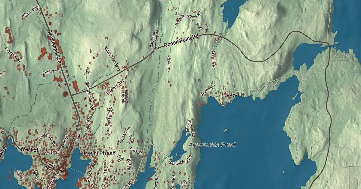
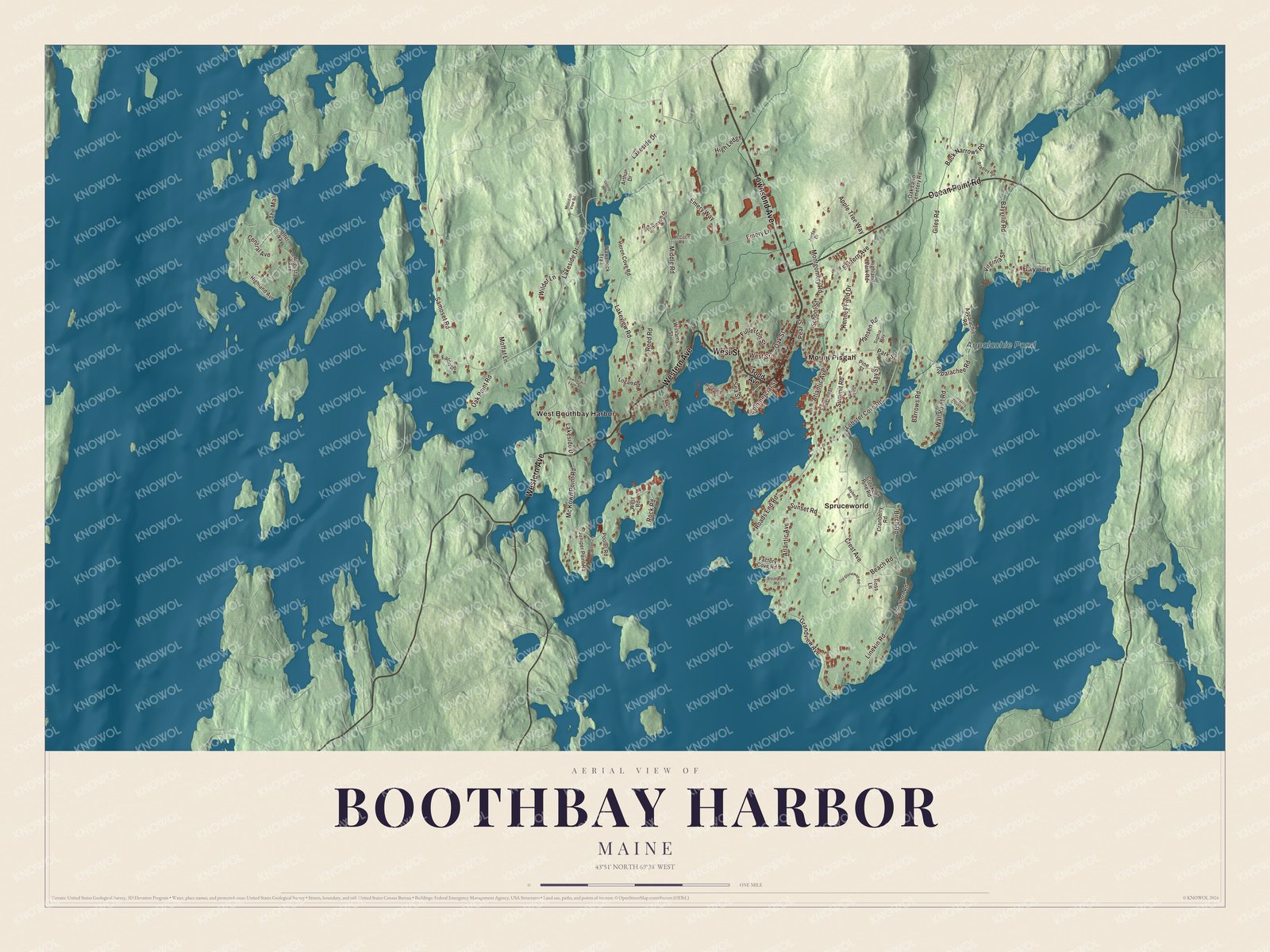
This map of Boothbay Harbor prints Townsend Avenue by name, along with West Street, Western Avenue, Ocean Point Road, Lakeside Drive and Mc Kown Point Road. Look for Bayville and Mount Pisgah, then Spruceworld, West Boothbay Harbor and Appalachie Pond. Click here to purchase a print of this map for your wall.
Boothbay Harbor is a town in Lincoln County, home to 2,027 people at the 2020 census.
KNOWOL made this map in 2026 from public survey data and gave it the look of an old atlas. The relief is shaded from United States Geological Survey elevation data, and the streets and town line come from the Census Bureau. The bureau measures the town at 9.22 square miles, and 3.52 of them are water. It sits at the south end of a peninsula reaching into the Gulf of Maine, with the tidal Sheepscot River to the west and Linekin Bay to the east, and the larger town of Boothbay to the north and east.
Winnegance, Townsend and Boothbay
The Abenaki people who lived here called the region Winnegance. In 1623 the English kept a fishing outpost at Cape Newagen, and in 1666 an Englishman named Henry Curtis bought the right to settle Winnegance from the Abenaki sachem Mowhotiwormet. The English were driven out twice in the wars that followed, and for 40 years the place stood empty. In 1730 Colonel David Dunbar, governor of the Territory of Sagadahock, started a new settlement named Townsend, after Lord Charles Townshend, and in 1764 it was incorporated as the town of Boothbay. During the Penobscot Expedition of 1779, Boothbay was a meeting point for the American fleet.
The town page credits the settlement’s success in part to its large, deep and protected harbor. It grew into a fishing center that could hold 400 to 500 vessels at a time in bad weather, many of them Friendship Sloops. By 1881 it had a fishery and fish oil company, an ice company, two marine railways, a fertilizer works and a lobster cannery. On February 16, 1889, the harbor community was set off from Boothbay and incorporated as the town of Boothbay Harbor. The Frank L. Sample shipyard here built minesweepers for the United States Navy during World War II and into the 1950s, and some of the 1956 film of Rodgers and Hammerstein’s Carousel, including the “June Is Bustin’ Out All Over” number, was shot in the town.
Burnt Island Light stands at the western entrance to the harbor. It was built in 1821, and its page calls it the second oldest surviving lighthouse in Maine. Its original fixed white light was meant to draw ships into the harbor rather than warn them away, and it was the last lighthouse in Maine to be converted from kerosene. The state’s Department of Marine Resources now runs a living history museum there.
Click to explore a larger preview. The digital watermark does not appear on printed maps.
See it on a wall
The Boothbay Harbor map as a framed print. Swipe for more.


Townsend Avenue and the neighborhoods
Townsend Avenue is printed on the map. It shares its name with the old Townsend settlement, and at 86 Townsend Avenue stands the Opera House at Boothbay Harbor, built in 1894 by the Pythian Hall Company to a design by the Portland firm of Francis H. Fassett and his son Edward. It held the town offices into the 1930s, the Knights of Pythias and the Masons into the 1960s and town meetings into the 1970s, and when it went up it towered over a village of mostly one and two-story buildings. Since 2005 it’s been a performance hall again. On the rise above downtown, in the block formed by Oak Street, McClintock Street and Townsend Avenue, the Auld-McCobb House was built in 1807 for the merchants Jacob Auld and Joseph McCobb, partners in fishing, shipbuilding and trade. Its page calls it the town’s oldest brick house. Nearby at 4 Oak Street, a Greek Revival house of 1842 has been the Boothbay Harbor Memorial Library since the town bought it in 1923, and it also serves as a memorial to the town’s soldiers of the First World War.
Bayville and Mount Pisgah are printed on the map. The town page counts Mount Pisgah among its neighborhoods and places Bayville next to the eastern border, close to East Boothbay. West Boothbay Harbor is printed too, and the page places that village in the west-central part of town. Spruceworld is printed as well. The town page spells the Spruce Point neighborhood Sprucewold, and Sprucewold Lodge, built in 1927, was the centerpiece of a rustic resort there. Its page calls it one of the state’s finest examples of Adirondack-style log architecture.
West Street, Western Avenue, Lakeside Drive and Mc Kown Point Road are printed on the map, along with Appalachie Pond. Ocean Point Road is printed too. Route 96 leads east from town to the village of East Boothbay and ends at Ocean Point.
This Boothbay Harbor map makes a handsome addition to an office, library or den, and it can teach children the geography and history of a working harbor town. It’s made for anyone who calls Boothbay Harbor home, from Bayville to West Boothbay Harbor, as it looks today. Zoom in on the preview above to explore the details, then click here to get your copy of the Boothbay Harbor, Maine map.

Sources