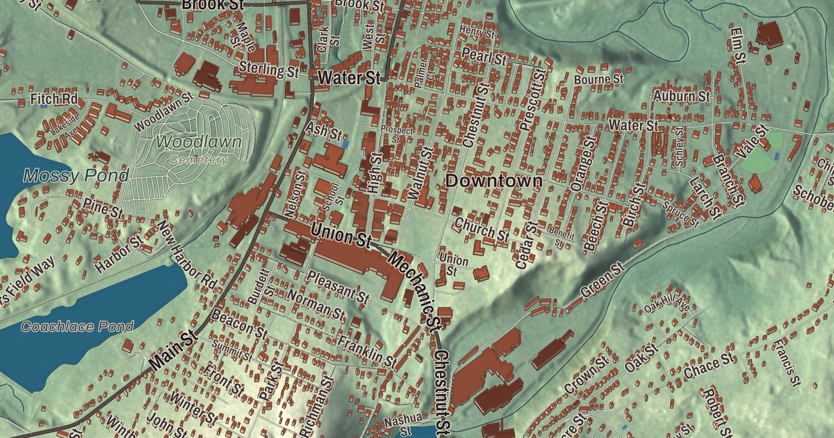
Clinton is a compact mill town on the Nashua River, with the Wachusett Dam holding back a great reservoir south of the town center. This map prints Main Street, High Street, Water Street, Sterling Road, Boylston Street and West Boylston Road, with South Meadow Pond, Mossy Pond, Clamshell Pond, Coachlace Pond, Burdett Hill and Cemetery Island. Click here to purchase a print of this map for your wall.
Clinton is in Worcester County, between Lancaster to the north and Boylston to the south.
KNOWOL made this map in 2026 from public survey data and gave it the look of an old atlas. The relief comes from United States Geological Survey elevation data, and the streets and the town line come from the Census Bureau. Clinton covers 7.3 square miles, 1.6 square miles of it water, and the large Wachusett Reservoir lies south of the town center. Bolton and Berlin lie to the east and Sterling to the west. The town had 15,428 people at the 2020 census.
The Bigelow brothers’ town
The Town of Clinton’s recorded history, in the Secretary of the Commonwealth’s list, dates European settlement to 1654, when this was part of Lancaster, on land Sachem Sholan of the Nashaway had deeded in 1643. Clinton was incorporated as a town in 1850, on March 14, and the town remains part of Worcester County today. Its founders were Erastus Brigham Bigelow and his brother Horatio, and they named the new town after the DeWitt Clinton Hotel in New York, a favorite of theirs.
Erastus Bigelow was an inventor of weaving machines. He built a power loom for coach lace, then one that wove two-ply ingrain carpet far faster than a handloom, and then his most important invention, a power loom for Brussels and velvet carpets that drew wide notice at the World’s Fair in London in 1851. His Bigelow Carpet Mill, at Union and High Streets just south of downtown, began in 1849 in an older building and grew until 1922 into one of the world’s major early automated makers of Brussels carpet. The oldest surviving building dates to 1855, the complex has been on the National Register since 1978, and it’s now headquarters for Nypro, a maker of medical devices. The coach-lace works and the Lancaster Quilt Company came out of his inventions too, and his page credits him with the town’s growth and manufacturing importance. In 1846 he founded the Bigelow Mechanics Institute, today the Bigelow Free Public Library, and he was one of the original incorporators of the Massachusetts Institute of Technology.
Clinton grew into a full mill town on the Nashua River’s water power, and by 1890 it was known for carpets and woven wire. Railroads came to serve the mills, among them the Central Massachusetts Railroad, part of whose line, abandoned in 1958, includes a tunnel near Clamshell Road.
The dam and the reservoir
When greater Boston needed new water, the Metropolitan Water Board chose the south branch of the Nashua River at Clinton over Lake Winnipesaukee, Sebago Lake and the Merrimack. Work on the Wachusett Dam began in 1897 and finished in 1905, and the reservoir filled in 1908, flooding a large part of Clinton and neighboring towns; homes, churches, factories and schools in the valley were torn down or moved, and the work drew thousands of immigrants. When it was finished, the reservoir was the largest public water supply reservoir in the world and the dam the largest gravity dam in the world, and the dam is still considered the largest “hand dug” dam in the world. Today the Wachusett Reservoir is the second largest body of water in Massachusetts, part of the water system the Massachusetts Water Resources Authority keeps for metropolitan Boston.
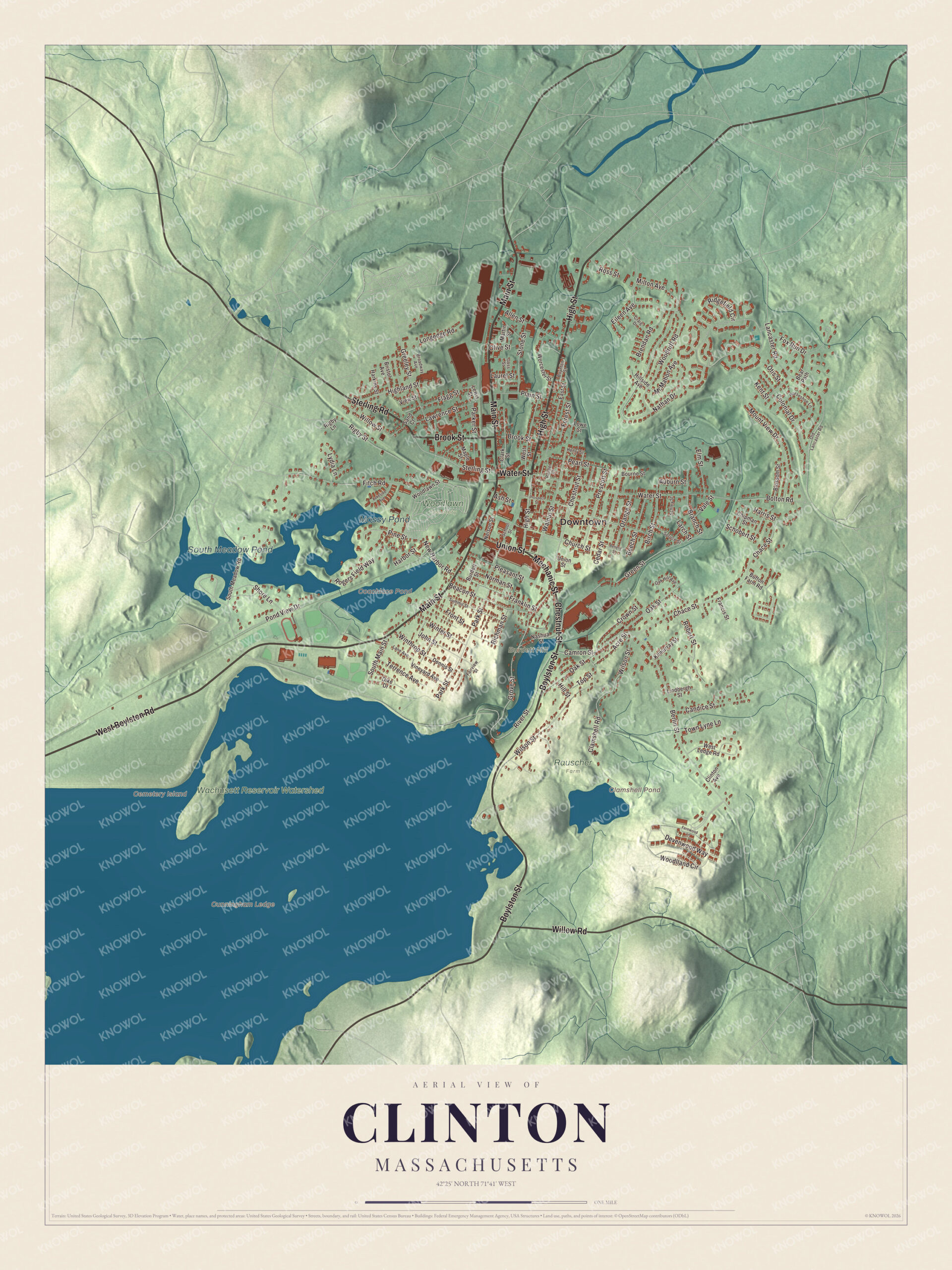
Click to explore a larger preview. The digital watermark does not appear on printed maps.
Names on this map
These names are printed on this map.
Places: Downtown, Burdett Hill, Cemetery Island, Cunningham Ledge, Clamshell Pond, Coachlace Pond, South Meadow Pond, Mossy Pond, Rauscher Farm, Wachusett Reservoir Watershed and Woodlawn Cemetery.
Streets and roads: High Street, Sterling Road, Water Street, West Boylston Road, Main Street, Boylston Street, Brook Street, Chestnut Street, Mechanic Street, Willow Road, Union Street, Sterling Street.
More street names, A to Z
Acre Street, Allen Street, Ash Street, Auburn Street, Beacon Street, Bear Path, Beech Street, Benefit Street, Berlin Street, Birch Street, Blossom Street, Bolton Road, Bourne Street, Boynton Street, Branch Street, Brendan Road, Bristol Avenue, Broadway Avenue, Bufton Farm Road, Burdett Street, Camron Street, Candice Street, Cedar Street, Chace Street, Chipman Street, Church Street, Clamshell Road, Clark Street, Clinton Avenue, Colonial Drive, Craig Drive, Crown Street, Dennis Street, Devenwood Way, Dike Drive, East Street, Eileen Avenue, Elm Street, Fairview Street, Fernwood Lane, Fitch Road, Flagg Street, Forest Street, Fox Run Drive, Francis Street, Franklin Street, Front Street, Goss Street, Greeley Street, Green Street, Grove Street, Harbor Street, Harkins Street, Harris Street, Henry Street, Highland Street, Hillside Avenue, Hill Street, Horseshoe Lane, John Street, Kent Street, Kilmurray Street, Lakeside Avenue, Lancaster Road, Lane Avenue, Larch Street, Laurel Street, Lawrence Street, Lewis Street, Lindbergh Street, Longedge Road, Lowe Street, Lydia Lane, Maple Street, Martin Street, McMahon Avenue, Milton Avenue, Mount View Drive, Nashua Street, Nathan Drive, Nelson Street, New Harbor Road, Norman Street, Oak Hill Avenue, Oak Street, Old Lancaster Road, Olive Street, Orange Street, Otis Street, Palmer Court, Parker Street, Park Street, Pearl Street, Pine Street, Plain Street, Pleasant Street, Pond View Drive, Prescott Street, Prospect Street, Richman Street, Ridgefield Circle, Rigby Lane, Rigby Street, River Street, Robert Street, Rogers Field Way, Ross Street, Sand Court, Schley Street, Schobert Street, School Street, Shore Lane, South Main Street, South Meadow Road, Spruce Street, Stone Street, Summit Street, Terrence Avenue, Top Street, Town Lyne Lane, Vale Street, View Street, Vineyard Avenue, Walnut Street, West Ledge Road, West Street, Willow Street, Wilson Street, Winter Street, Winthrop Street, Woodlawn Street, Woodlland Circle, Woodruff Road, Worcester Street.
See it on a wall
The Clinton map as a framed print. Swipe for more.


Fuller Field
Clinton claims to have the oldest continuously used baseball field in the world, Fuller Field, laid out in 1878. London, Ontario, makes the same claim for Labatt Memorial Park, which dates to 1877, and Clinton answers that the London field has been flooded and rebuilt twice, its bases turned around, and doubts that it stayed in continuous use after an 1883 flood. Fuller Field is home to the Clinton 76ers, a semi-pro men’s team that won the 2017 league title. Clinton’s notable people include the Hall of Fame ballplayer Sliding Billy Hamilton, the actress Agnes Moorehead and the Pulitzer Prize-winning reporter Sydney Schanberg.
Around the map
Start downtown, then follow High Street, Sterling Road, Water Street, West Boylston Road, Main Street and Boylston Street across town. Central Park and the Clinton business district are among the town’s sites of interest. Out in the reservoir, Cemetery Island takes its name from an old burial ground the water covered; the graves were moved to St. John’s Cemetery in Lancaster. Below the dam, the South Nashua River runs north to meet the North Nashua in Lancaster. Clamshell Pond, Coachlace Pond, South Meadow Pond, Mossy Pond, Burdett Hill and Cemetery Island are all printed on the map.
Clinton’s map makes a fine addition to an office, library or den, and it can help teach children the geography and history of the town the Bigelows built. It’s made for people who call Clinton home, and it shows the town as it looks today. Zoom in on the preview above to explore the details, then click here to get your copy of the Clinton, Massachusetts map.

Sources
- Clinton, Massachusetts, Wikipedia
- Erastus Brigham Bigelow, Wikipedia
- Bigelow Carpet Mill, Wikipedia
- Wachusett Dam, Wikipedia
- Wachusett Reservoir, Wikipedia
- Cemetery Island (Massachusetts), Wikipedia
- Nashua River, Wikipedia
- City and Town Incorporation and Settlement Dates, Secretary of the Commonwealth of Massachusetts (archived copy)