
A hill town on the New Hampshire line that began as the soldiers' grant of Dorchester-Canada, where the brooks once turned chair shops and match mills, Mount Watatic bent the surveyors' compass, and Cushing Academy keeps its hill above the center.
Then and now
The same town 140 years apart. Click either map to look closer.
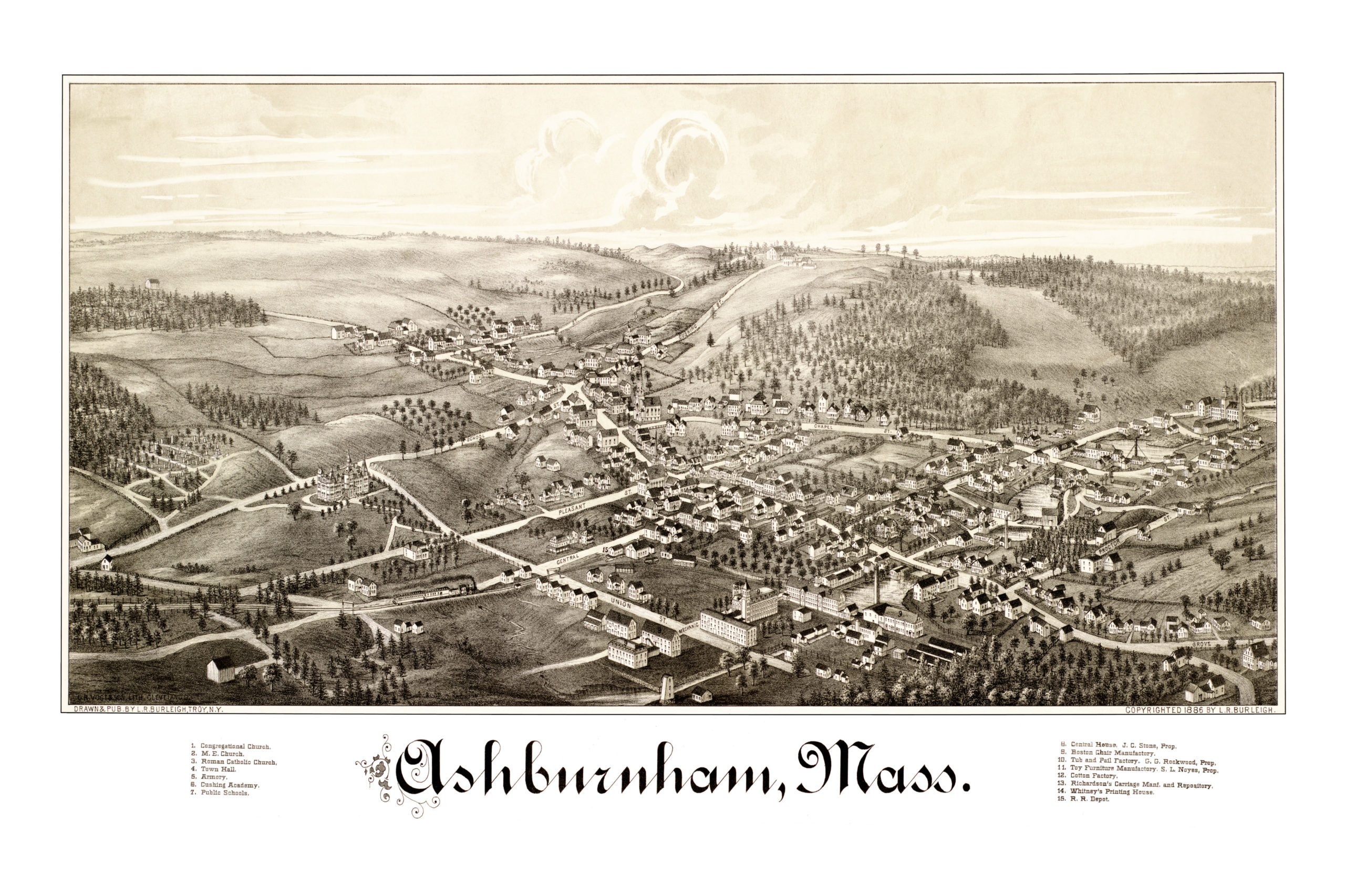
Ashburnham in 1886
By Lucien R. Burleigh
A hand-drawn bird's-eye view of Ashburnham when fewer than 2,000 people lived in town, with Cushing Academy, the Town Hall, Whitney's Printing House, the Armory, the public schools and the Ashburnham Railroad depot.5
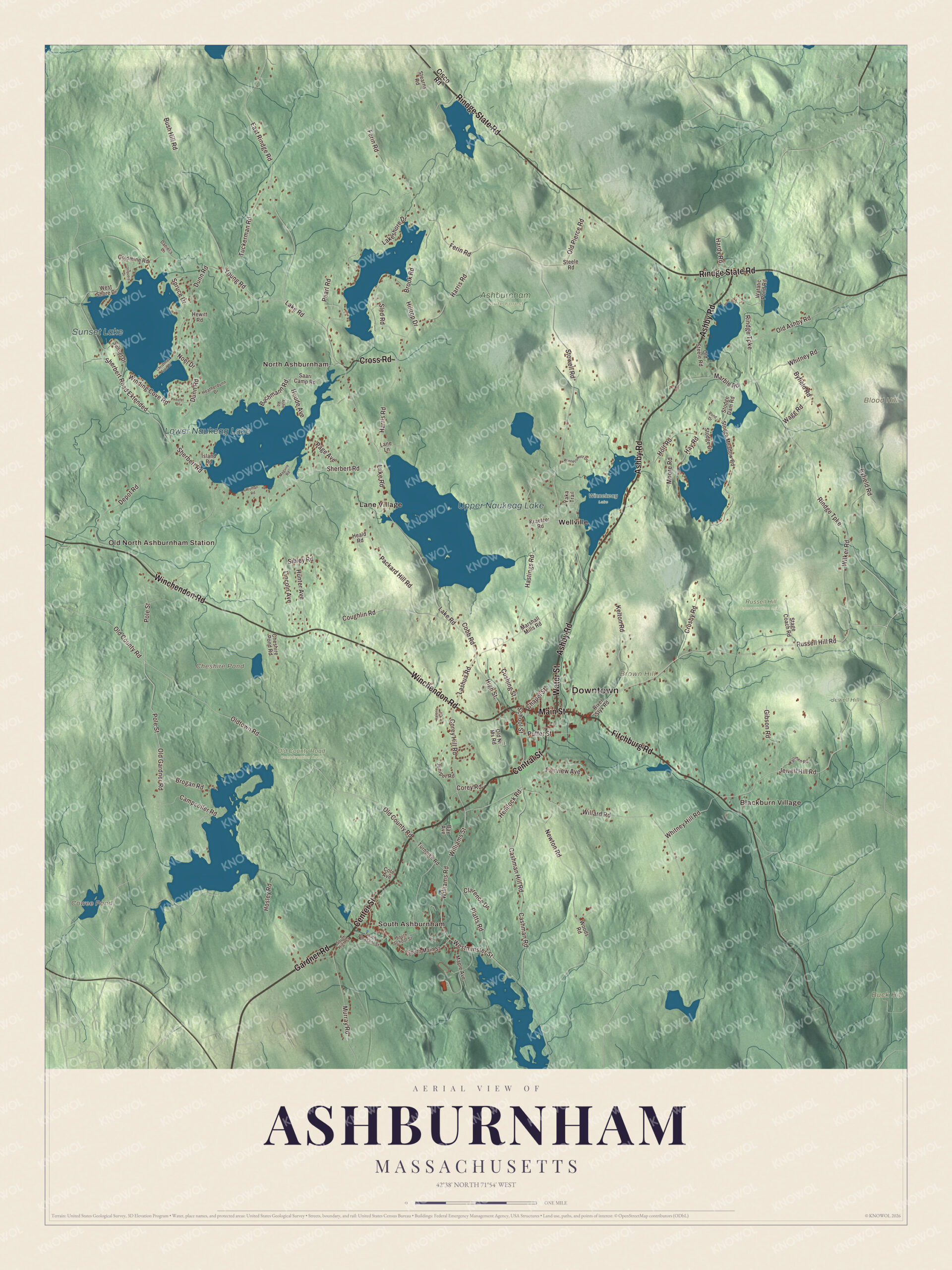
Ashburnham today
By KNOWOL
Shaded hills and lakes across the whole town, with Upper and Lower Naukeag Lake, Cheshire Pond and Cowee Pond, Blood, Brown and Buck hills, Blackburn Village and Lane Village, and Main Street, Gardner Road, Fitchburg Road and Rindge State Road.2
The story of Ashburnham
The needle that bent at Watatic
When the line between Ashburnham and Ashby was run, the surveyors started at the New Hampshire line and headed southeast by compass. At the foot of Mount Watatic something in the ground pulled the needle aside, and the line swung east. The two towns' selectmen reported that a mine had drawn the needle. The town's 1887 history says the line was run according to the needle and not according to law, and that it was kept anyway. The mountain itself drew praise. Gazetteers of 1874 and 1890 promised a splendid view from its top, of Monadnock, Wachusett and a country dotted with lakes and villages. The 1890 book adds that Ashburnham Junction's station was said to be the highest point on the railroad between Boston and the Rocky Mountains.678
Chairs, matches and a railroad of its own
Ashburnham ran on wood and water. In 1874 a state gazetteer counted at least ten ponds, Naukeag the biggest at 302 acres, and Phillips Brook driving chair shops through the center. North Ashburnham had ten or twelve sawmills, and wooden ware and lucifer matches came out of town with great rapidity. By 1887 the town's historian could say Ashburnham gave way only to Gardner in chairs and had no other rival. To reach the center village the town built its own short railroad, and townspeople put $88,500 into it. Mrs. Winchester owned and ran it until 1885, when the Fitchburg Railroad bought it. In 1917 Wright's crutch factory was still turning out 3,500 crutches a month.9101112
Starting over on the hill
Ashburnham began as Dorchester-Canada, land granted to soldiers of a 1690 expedition to Canada. Settlers came in 1736, and a house for travelers already stood on the old road to Northfield. About 1744, fearing attack, the families left. Tavern keeper Timothy Mosman stayed behind to look after the meetinghouse and board up its doors and windows. People came back, and the town was incorporated in 1765. Its first meetinghouse stood on a hilltop north of today's center. Rev. Jonathan Hill preached the first Methodist sermon here in 1793, and Lorenzo Dow came through in 1796. Getting around stayed hard: in 1812 the first four-wheeled family wagon in town was parked in the village so people could look at it.1131415161718
Through the years
24 moments from 1690 to today.
- 1690Soldiers go on the expedition to Canada whose land grant becomes Dorchester-Canada.1
- 1734A 1,000-acre tract here is granted to Cambridge for keeping up the first bridge over the Charles River.19
- 1735A house for travelers goes up on a 450-acre grant along the old Northfield road in the northwest of town.13
- 1736European settlement begins.1
- 1744About this year the settlement is abandoned for fear of attack, and Timothy Mosman stays behind to board up the meetinghouse.14
- 1765Dorchester-Canada is incorporated as the town of Ashburnham.1
- 1770John Adams of Menotomy and his bride, Joanna Munroe, become the first settlers on the Cambridge grant.19
- 1793Rev. Jonathan Hill preaches the first Methodist sermon in town.16
- 1796The traveling preacher Lorenzo Dow comes to Ashburnham.17
- 1812The first four-wheeled family wagon in town is parked in the village for people to admire.18
- 1834A new Congregational church on Main Street replaces the old meetinghouse on the hill.15
- 1847Enoch Whitmore shelters the Thomas family, who had escaped slavery in Maryland, at his farm.20
- 1855The population reaches 2,211, its high point of the 1800s.3
- 1862Lieutenant Colonel Joseph P. Rice of Ashburnham is killed at the battle of Chantilly.21
- 1865The Cushing Academy corporation is organized with $96,000 from Thomas Parkman Cushing's will.22
- 1874A state gazetteer finds ten or twelve sawmills at North Ashburnham and lucifer matches made in town.9
- 1875Cushing Academy opens with 66 boys and 56 girls.23
- 1885The town's own Ashburnham Railroad is sold to the Fitchburg Railroad.11
- 1886Lucien R. Burleigh draws his bird's-eye view of Ashburnham.5
- 1890The Stevens Library is built in the center village.15
- 1904A new Town Hall is built.15
- 1913Ivers Whitney Adams gives the town Bela Pratt's statue, the Schoolboy of 1850.2
- 1917Wright's crutch factory is making 3,500 crutches a month.12
- 2002Ashburnham, Ashby, their land trusts and the state buy Mount Watatic as conservation land.2
Places to see
Places worth a visit in Ashburnham today.
- Cushing AcademyHill above the town center. Boarding school, opened in 1875.Visit their website
- The Schoolboy of 1850Main and School streets. Bela Pratt statue, given in 1913.
- Mount WataticOn the Ashby line. 1,832-foot summit, protected in 2002.Visit their website
- Wapack TrailStarts at Mount Watatic. Long ridge trail north into New Hampshire.Visit their website
- Midstate TrailStarts at Mount Watatic. Long trail south across Massachusetts.Visit their website
- Upper Naukeag LakeAbove Lower Naukeag Lake. Spring-fed, the town's water supply.
- Lower Naukeag LakeNear North Ashburnham. Fed by the North Ashburnham stream.
- Cambridge Grant Historic DistrictRussell Hill Road. Federal farmhouses of 1787 to 1834.
- South AshburnhamSouth end of town. Depot village of chair shops.
On the National Register
All 3 places in Ashburnham on the National Register of Historic Places that still stand today, oldest first, and why each one matters.4
-
Cambridge Grant Historic District
Land granted to Cambridge in 1734 to pay for keeping up the Charles River bridge, settled from 1770 by the Adams and Russell families of Menotomy, who tanned Morocco leather. It keeps seven Federal houses of 1787 to 1834 in their original setting, and in the early 1900s it was a summer arts colony.19
-
Enoch Whitmore House
A large Federal farmhouse in the remote northwest of town. Enoch Whitmore, an abolitionist, sheltered the Thomas family on his farm in 1847 after they escaped slavery in Maryland, and the family later settled in Ashburnham.20
-
Ashburnham Center Historic District
The village between two branches of Phillips Brook that grew with its mills from 1830 to 1855. It keeps 189 historic buildings, including Greek Revival houses, the 1834 Congregational church, the town house built from the old meetinghouse timbers, the Stevens Library of 1890 and the Town Hall of 1904.15
In their words
“both in the number and the value of the annual product, Ashburnham yields the palm to Gardner and surveys the remaining field without a peer.”
History of Ashburnham, 1887, on the town's chair makers10
“It is young in years and limited in length, yet it has more history to the linear mile and in certain years of its duration has developed more stratagem than has attended the fortunes of many older and longer roads.”
History of Ashburnham, 1887, on the Ashburnham Railroad24
“a most splendid view of Monadnock, Wachusett, and other more distant mountains, together with a vast panorama dotted with lakes, woods, and villages, is obtained.”
Gazetteer of the State of Massachusetts, 1874, on the view from Watatic7
Nearby towns
Sources
- Ashburnham, Massachusetts, Wikipedia
- Map of Ashburnham, Massachusetts in 2026, KNOWOL (USGS elevation, Census Bureau roads)
- History of Worcester County, Massachusetts (1889), on Ashburnham's post offices and population, Internet Archive
- National Register of Historic Places listings in northern Worcester County, Massachusetts, Wikipedia
- Old map of Ashburnham, Massachusetts from 1886, restored by KNOWOL
- History of Ashburnham, Massachusetts (1887), on the Ashby line, Internet Archive
- Gazetteer of the State of Massachusetts (1874), on Ashburnham, Internet Archive
- A gazetteer of the state of Massachusetts (1890), on Ashburnham's villages and hills, Internet Archive
- A gazetteer of the state of Massachusetts (1874), on Ashburnham's ponds and mills, Internet Archive
- History of Ashburnham, Massachusetts (1887), on chair making, Internet Archive
- History of Ashburnham, Massachusetts (1887), on the cost and sale of the Ashburnham Railroad, Internet Archive
- The forests of Worcester County (1917), on Ashburnham, Internet Archive
- History of Worcester County, Massachusetts (1889), on the old Northfield road, Internet Archive
- History of the town of Princeton, Massachusetts, 1759-1915 (1915), on Timothy Mosman, Internet Archive
- Ashburnham Center Historic District, Wikipedia
- History of Worcester County, Massachusetts (1889), on Ashburnham's churches, Internet Archive
- History of Worcester County, Massachusetts (1879), on Ashburnham's churches, Internet Archive
- History of Worcester County, Massachusetts (1879), on travel in Ashburnham, Internet Archive
- Cambridge Grant Historic District, Wikipedia
- Enoch Whitmore House, Wikipedia
- History of Worcester County, Massachusetts (1889), on Ashburnham in the Civil War, Internet Archive
- History of Worcester County, Massachusetts (1889), on Cushing Academy, Internet Archive
- Cushing Academy, Wikipedia
- History of Ashburnham, Massachusetts (1887), on the railroads, Internet Archive