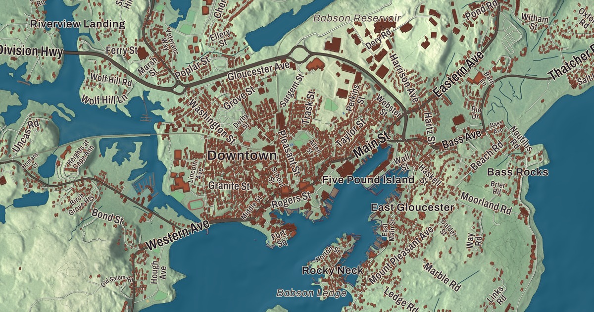
Gloucester has fished from its harbor since 1623, and this map takes in the whole city around it, from Wingaersheek Beach to the harbor. It prints Washington Street, Main Street, Eastern Avenue, Western Avenue, Thatcher Road and the Yankee Division Highway, with Wingaersheek Beach, Babson Reservoir, Dykes Pond, Haskell Pond and Buswell Pond. Click here to purchase a print of this map for your wall.
Gloucester is in Essex County.
KNOWOL made this map in 2026 from public survey data and gave it the look of an old atlas. The relief comes from United States Geological Survey elevation data, and the streets and the city line come from the Census Bureau. Gloucester sits on Cape Ann, on Massachusetts’s North Shore, with an urban core on the north side of the harbor and outlying neighborhoods at Annisquam, Bay View, Lanesville, Folly Cove, Magnolia, Riverdale, East Gloucester and West Gloucester. It had 29,729 people at the 2020 census.
Le Beau Port
The Agawam people under the sachem Masconomet lived here when Europeans arrived, and there’s evidence of a village on Pole’s Hill in today’s Riverdale. In 1606 Samuel de Champlain explored the harbor and drew the first known map of it, calling it le Beau port. In 1623 men from the Dorchester Company set up a permanent fishing outpost, and Roger Conant, governor under the Cape Ann patent, has been called the first governor of Massachusetts. That first settlement was hard and short. Around 1626 the settlers moved to Naumkeag, now Salem, and took their meetinghouse and the governor’s house with them. Stage Fort Park, at Stage Head, keeps the story: the head is named for a fishing “stage” of the Dorchester company’s settlement, and it’s the most likely first site of Conant’s Great House.
The City of Gloucester’s recorded history, in the Secretary of the Commonwealth’s list, dates European settlement to 1623. Gloucester was incorporated as a town in 1642, the year its name first shows up on the tax rolls, and it was incorporated as a city in 1873. The town once took in Rockport too, an area called Sandy Bay, which split off on February 27, 1840. The resettled town grew up first around the Town Green at a bend in the Annisquam River, now Grant Circle, where Route 128 meets Washington Street, nearly two miles from the harbor.
A city that goes to sea
Gloucester was an important shipbuilding center, and the first schooner was reputedly built here in 1713. With Georges Bank and the fishing banks off Nova Scotia and Newfoundland within reach, it grew into an important fishing port. Portuguese and Italian families came in the late 1800s to work in the fishery, and some of today’s fishermen descend from them. Gorton’s of Gloucester began in 1849 as John Pew & Sons. In 1925 the General Seafood Corporation moved to Gloucester to sell Clarence Birdseye’s new double belt freezer, which froze packaged fish quickly. In 2013 the port still ranked 21st in the country for fish landings.
The schooner Adventure, launched in Essex in 1926, fished the Grand Banks out of Gloucester until 1953. She’s one of only two surviving knockabout fishing schooners, built without a bowsprit to keep crews safer, and she became a National Historic Landmark in 1994. Howard Blackburn, a Gloucester fisherman, lost his fingers to frostbite after rowing a dory for five days to Newfoundland in 1883, came home a hero, opened a business with the town’s help, and later sailed alone across the Atlantic twice.
On the harbor stands the Gloucester Fisherman’s Memorial, the Man at the Wheel, an 8-foot bronze fisherman in oilskins braced at the wheel. The English sculptor Leonard Craske designed it for the city’s 300th anniversary, to remember the thousands of fishermen lost at sea, and it was cast in 1925. Its base carries words from Psalm 107: “They That Go Down To The Sea In Ships 1623-1923.” Each June the Italian American community holds St. Peter’s Fiesta for the patron saint of fishermen. It began in 1927, when fishermen set up a statue of St. Peter in the Italian district, and now brings seine boat races and the Greasy Pole contest.
Painters, writers and a first church
Judith Sargent Murray was born in Gloucester in 1751. She was one of the first Americans to argue for the equality of the sexes, in her essay “On the Equality of the Sexes,” and her family helped found the first Universalist Church in the nation, with John Murray as its first pastor. Their house survives as the Sargent House Museum. Fitz Henry Lane, the marine painter, returned home to Gloucester in 1848 and built a house and studio on Duncan’s Point, which still stands on the waterfront. The Cape Ann Museum holds the premier collection of his work, 40 paintings and 100 drawings. Rocky Neck, a peninsula in the working harbor, is one of the oldest continuously operating art colonies in the country, where Winslow Homer and Edward Hopper worked. Rudyard Kipling set Captains Courageous here, and T. S. Eliot named one of his Four Quartets for the Dry Salvages, rocks off the city’s northeast coast.
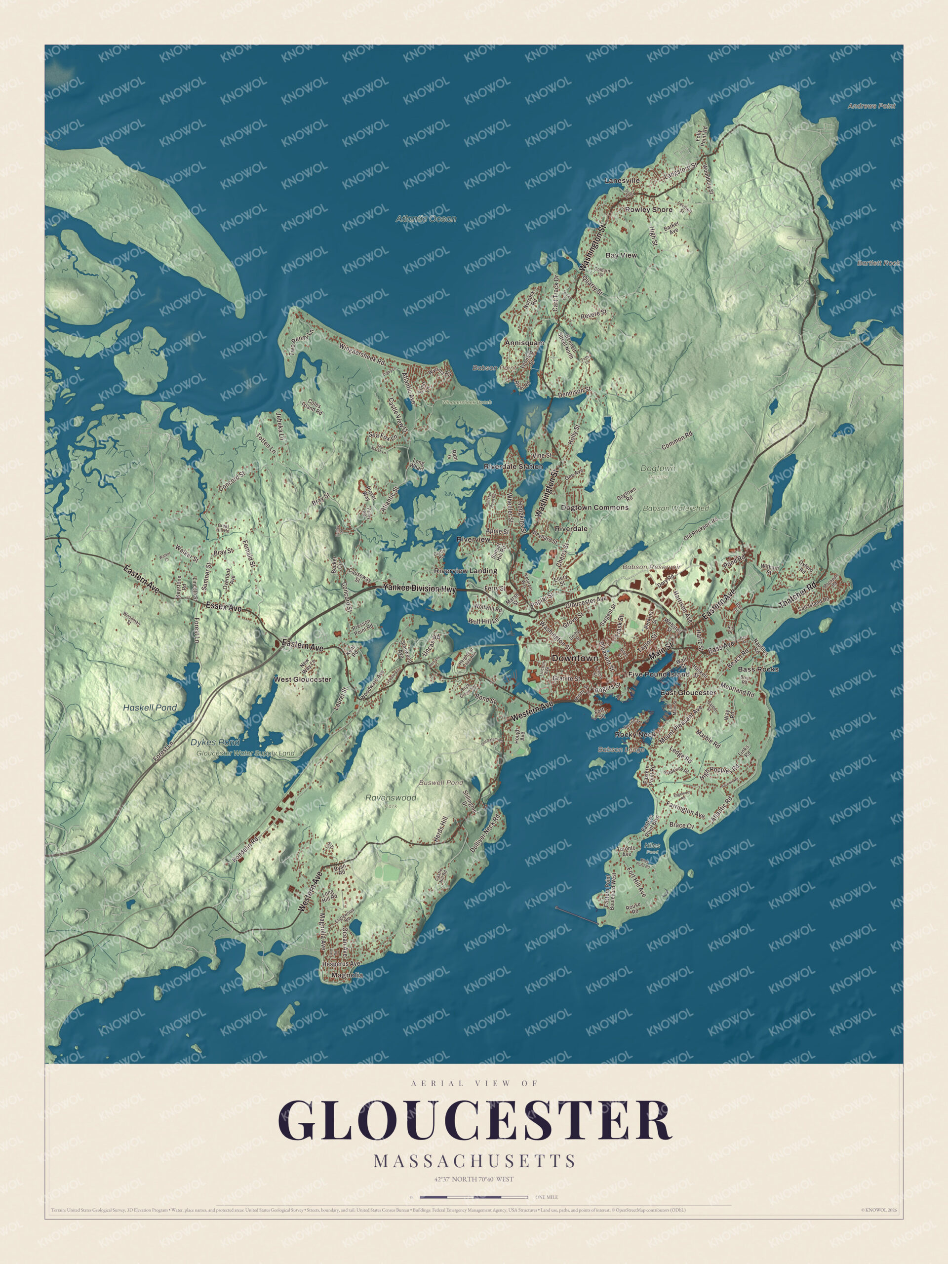
Click to explore a larger preview. The digital watermark does not appear on printed maps.
Names on this map
These names are printed on this map.
Places: Downtown, Magnolia, Andrews Point, Babson Ledge, Babson Point, Bartlett Rock, Babson Reservoir, Buswell Pond, Dykes Pond, Haskell Pond, Atlantic Ocean, Babson Watershed, Dogtown Woods, Gloucester Water Supply Land, Niles Pond, Ravenswood Park, Wingaersheek Beach, Annisquam, Bass Rocks, Bay View, Dogtown Commons, East Gloucester, Five Pound Island, Lanesville, Riverdale, Riverdale Station, Riverview, Riverview Landing, Rocky Neck, Rowley Shore and West Gloucester.
Streets and roads: Yankee Division Highway, Eastern Avenue, Main Street, Western Avenue, Washington Street, Thatcher Road, Essex Avenue, Magnolia Avenue, Sea Fox Lane, Concord Street, Atlantic Road, Hesperus Avenue.
More street names, A to Z
Allen Street, Ames Drive, Apple Street, Atlantic Avenue, Atlantic Street, Barker Avenue, Barn Lane, Bass Avenue, Beach Road, Becker Circle, Bennett Street North, Birch Grove Heights, Bond Street, Brace Cv, Bray Street, Brier Road, Calder Street, Cart Track Drive, Castle Hill Road, Castle View Drive, Causeway Street, Cherry Street, Colburn Street, Coles Island Road, Common Road, Crafts Road, Dennison Street, Derby Street, Digby Lane, Dogtown Road, Dolliver Neck Road, Dory Road, Duley Street, Eastern Point Boulevard, Eastern Point Boulevard West, Eastern Point Road, East Main Street, Edgemoor Road, Ellery Street, Elmo Lane, Englewood Road, Farrington Avenue, Fenley Road, Fernald Street, Ferry Street, Field Road, Folly Point Road, Forest Lane, Fort Hill Avenue, Fort Square, Gee Avenue, Gloucester Avenue, Granite Street, Grapevine Road, Great Hill Road, Grove Street, Harriett Road, Harrison Avenue, Hartz Street, Haskell Street, Heights at Cape Ann, Herds Hill, High Popples Road, High Street, Hodgkins Street, Holly Street, Homans Court, Horton Street, Hough Avenue, Jebeka Lane, Kent Road, Keystone Road, Kondelin Road, Langsford Street, Laurel Street, Ledge Road, Leonard Street, Leverett Street, Lincoln Avenue, Lincoln Street, Links Road, Lisa Drive, Long Hill Road, Long Wharf, Lyndale Avenue, Marble Road, Marsh Street, Middle Street, Moorland Road, Mount Pleasant Avenue, Nautilus Road, New Way Lane, Niles Pond Road, Norrock Road, Ocean Avenue, Old Rockport Road, Old Salem Road, Overlook Avenue, Oxford Road, Perkins Street, Pleasant Street, Plover Way, Pond Road, Poplar Street, Presson Point Road, Quarry Street, Ram Is, Revere Street, Reynard Street, Rio Drive, River Road, Rockport Road, Rogers Street, Rouse Road, Ryan Road, Salt Island Road, Salt Marsh Lane, Sargent Street, School Street, Stanwood Avenue, Stillington Drive, Sumner Street, Sunset Hill Road, Taylor Street, Thurston Point Road, Toronto Avenue, Totten Lane, Trask Street, Tufts Lane, Two Penny Lane, Uncas Road, Valley Road, Veterans Way, Vine Street, Walker Court, Walker Street, Wall Street, Way Road, Webster Street, Wheeler Street, Wingaersheek Road, Witham Street, Wolf Hill Lane, Wolf Hill Road, Woodbury Street, Woodman Street, Woodward Avenue, Wyoma Road.
Annisquam, Magnolia and Dogtown
Annisquam, a waterfront village across Cape Ann from downtown, takes its name from an Algonquian term for the top of a rock. Its first European settlement came in 1631, and Annisquam Harbor Light has stood at the mouth of the Annisquam River since 1801. Magnolia, in the southwest corner by the Manchester-by-the-Sea line, became a summer place for Bostonians after the Civil War. Hammond Castle sits there on a cliff above the water, built between 1926 and 1929 as the home, laboratory and museum of John Hays Hammond Jr., a pioneer of remote control. Inland, Dogtown is an abandoned village, first settled in 1693 and now split between Gloucester and Rockport. Its page says as many as 100 families lived there in the mid-1700s, and cellar holes and stone walls are about all that remain along the trails. Wingaersheek Beach, on the Annisquam River in West Gloucester, carries a name that grew out of the Dutch “Wyngaerts Hoeck.”
Around the map
Start with Magnolia, then follow the Yankee Division Highway, Eastern Avenue, Main Street, Western Avenue, Washington Street and Thatcher Road across the city. Look outward toward Annisquam, Bass Rocks, Bay View, Dogtown Commons and East Gloucester. Babson Reservoir, Buswell Pond, Dykes Pond, Haskell Pond and Wingaersheek Beach are all printed on the map. The Yankee Division Highway, Route 128, ends here in Gloucester, a few hundred feet from the ocean, and Eastern Avenue carries Route 127.
The Gloucester map makes a fine addition to an office, library or den, and it can help teach children the geography and history of a city that has gone down to the sea for four centuries. It’s made for people who call Gloucester home, from Magnolia to Annisquam, and it shows the city as it looks today. Zoom in on the preview above to explore the details, then click here to get your copy of the Gloucester, Massachusetts map.

We made a map for every town and city in Massachusetts. Explore the complete Massachusetts map collection and find your town.
Sources
- Gloucester, Massachusetts, Wikipedia
- Stage Fort Park, Wikipedia
- Clarence Birdseye, Wikipedia
- Adventure (1926 schooner), Wikipedia
- Howard Blackburn, Wikipedia
- Gloucester Fisherman’s Memorial, Wikipedia
- St. Peter’s Fiesta, Wikipedia
- Judith Sargent Murray, Wikipedia
- Fitz Henry Lane, Wikipedia
- Rocky Neck, Gloucester, Wikipedia
- Annisquam, Massachusetts, Wikipedia
- Magnolia, Massachusetts, Wikipedia
- Hammond Castle, Wikipedia
- Dogtown, Massachusetts, Wikipedia
- Wingaersheek Beach, Wikipedia
- Massachusetts Route 128, Wikipedia
- City and Town Incorporation and Settlement Dates, Secretary of the Commonwealth of Massachusetts (archived copy)