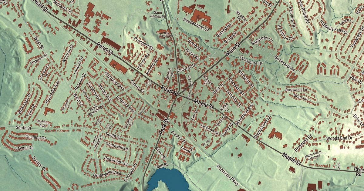
Everybody in Essex Junction knows Five Corners, where Main Street, Pearl Street, Maple Street, Park Street and Lincoln Street all come together near the railroad tracks. This map prints those five streets, and Colchester Road too.
Essex Junction is a city in Chittenden County, Vermont.
KNOWOL made this map in 2026 from public survey data and gave it the look of an old county atlas. The ground is shaded from United States Geological Survey elevation data, and the streets and city line come from the Census Bureau. Essex Junction covers 4.7 square miles, bordered on the south by the Winooski River, and it had 10,590 people at the 2020 census. Click here to purchase a print of this map for your wall.
The junction
Essex Junction started out in the early 1800s as a mill village, running on the water power of the Winooski River. Then the railroads came. The Vermont Central Railway built a station here in 1859, and with Burlington close by, the village became a major regional rail hub, with six different lines meeting in the area. Most of the downtown along Railroad Avenue and Main Street was built between 1900 and 1940, after a fire in 1893 burned nearly all of it, and that stretch is now the Downtown Essex Junction Commercial Historic District. At its center is the Brownell Block, a two-story brick building on the corner of Main Street and Railroad Avenue, and only one building there, 3 Main Street, is older than the fire.
Trains still stop here. Amtrak’s Vermonter runs daily through Essex Junction between St. Albans and Washington, D.C., and from 1953 until 2022 this was the closest passenger station to Burlington.
From IBM to GlobalFoundries
In 1958 IBM opened a data processing plant here with 500 workers. By 1969 it had grown to 820,000 square feet, and in 1982 it employed 8,000 people. The plant now belongs to GlobalFoundries, which runs a 200 mm wafer plant here along with a design center, and it’s described as the largest industrial facility in Vermont. With about 3,000 employees, GlobalFoundries is the largest private employer in the state.
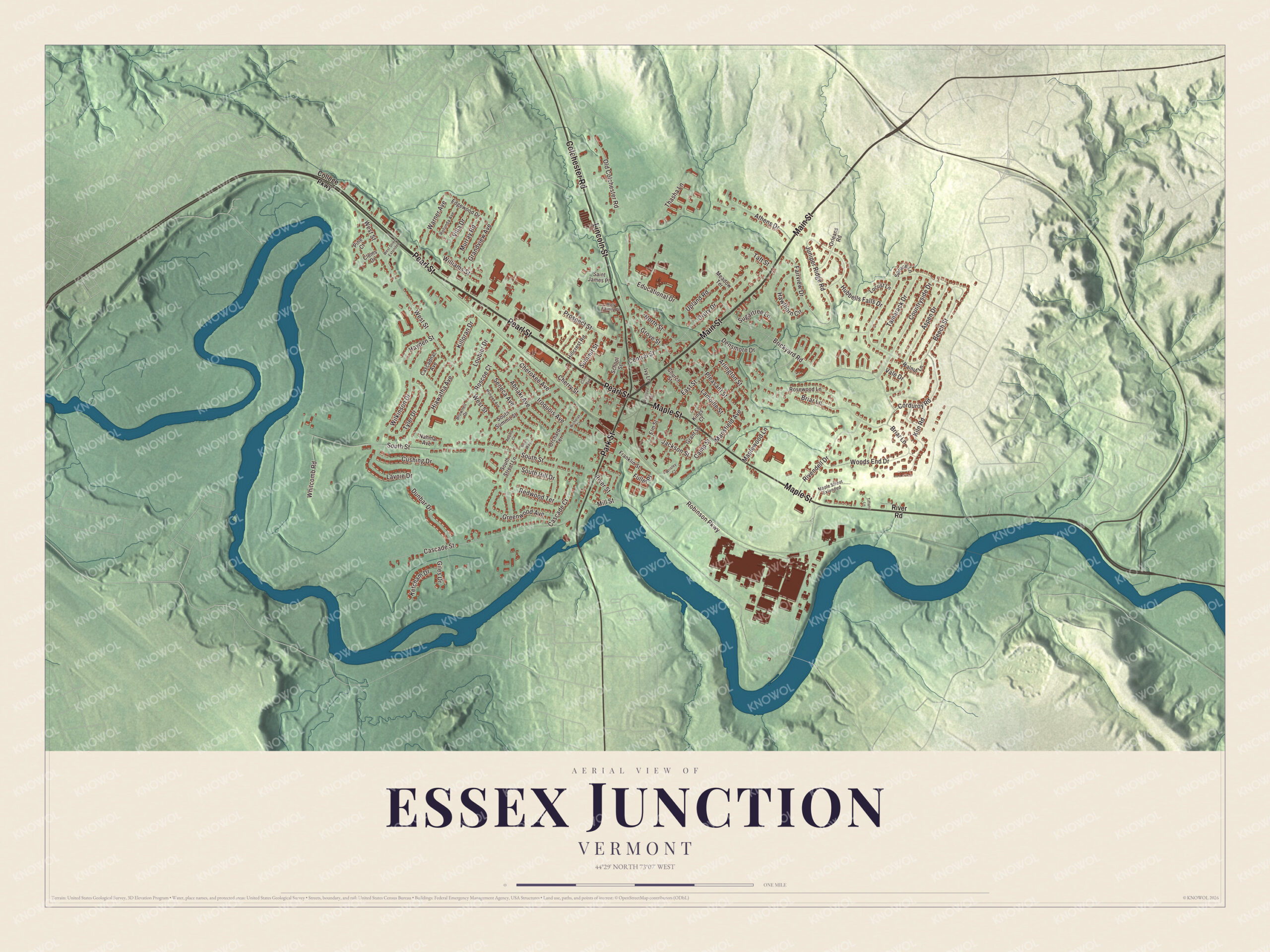
Click to explore a larger preview. The digital watermark does not appear on printed maps.
Names on this map
These names are printed on this map.
Streets and roads: Pearl Street, Main Street, Maple Street, Lincoln Street, Park Street, Colchester Road, Old Colchester Road, Williams Street, Robinson Parkway, South Street, West Street, Beech Street.
More street names, A to Z
Abnaki Avenue, Adams Court, Arlington Street, Aspen Drive, Athens Drive, Briar Lane, Brickyard Road, Brownell Drive, Camp Street, Cascade Court, Cascade Street, Cascadnac Avenue, Central Street, Cherokee Avenue, Cherry Street, Church Street, Clems Drive, College Parkway, Corduroy Road, Countryside Drive, Curtis Avenue, Cushing Drive, Densmore Drive, Doon Way, Drury Drive, Dunbar Drive, East Street, Edgewood Drive, Educational Drive, Elm Street, Fairview Drive, Franklin Street, Fuller Place, Giles Drive, Grandview Avenue, Grant Street, Greenwood Avenue, Grove Street, Hawthorn Circle, Hayden Street, Hiawatha Avenue, Hillcrest Road, Holy Family Place, Hubbells Falls Drive, Iroquois Avenue, Ivy Lane, Jackson Street, Juniper Ridge Road, Ketcham Drive, Killoran Drive, Kiln Road, Kings Court, Lamoille Street, Lavoie Drive, Locust Lane, Loubier Drive, Mansfield Avenue, Maple Street Extended, Maplewood Lane, Meadow Terrace, Mill Street, Mohawk Avenue, Murray Road, Nahma Avenue, Nicholas Court, North Street, Orchard Terrace, Orleans Road, Pine Court, Pleasant Street, Prospect Street, Railroad Street, Redwood Terrace, Rivendell Drive, River Road, River Street, Roscoe Court, Rosewood Lane, Rotunda Avenue, Saint James Place, School Street, Seneca Avenue, South Hill Drive, South Street Lane, South Summit Street, Spruce Lane, Sugartree Lane, Summit Street, Taft Street, Tamarack Drive, Thasha Lane, Tiffany Lane, Tyler Drive, Upland Road, Vale Drive, Villa Drive, Walnut Lane, Warner Avenue, West Street Extended, Whitcomb Road, Wilkinson Drive, Woods End Drive, Wrisley Court.
See it on a wall
The Essex Junction map as a framed print. Swipe for more.


The fair and the city
Essex Junction is home to the Champlain Valley Exposition, a former dirt racetrack turned event field with stadium seating for concerts, and to the Champlain Valley Fair. The fair runs ten days, it’s the state’s largest, and its attendance has reached almost 300,000 a year.
Essex Junction was incorporated as a village inside the town of Essex on November 15, 1892. On November 2, 2021, village voters chose by 3,070 to 411 to separate from the town, citing an unfair tax burden, and on July 1, 2022, Essex Junction became Vermont’s 10th city. The town of Essex still surrounds it on three sides. Among the people who grew up here is Loung Ung, who came from Cambodia as a young refugee, sponsored by Holy Family Church; her family’s first home was a small apartment above a dentist’s office at 48 Main Street. She became a human rights activist, and her memoir of surviving the Khmer Rouge years was made into a film in 2017.
Her first address, Main Street, leads straight to Five Corners. Main Street, Pearl Street, Maple Street, Park Street, Lincoln Street and Colchester Road are all printed on the map.
This map of Essex Junction is made for everyone who calls Essex Junction home and shows the city as it looks today, from Five Corners to the river. Hang it in an office, library or den, or use it to teach children the geography and history of Vermont’s 10th city. KNOWOL created it in 2026, and it’s printed on museum quality archival paper. Zoom in on the preview above to explore the details, then click here to get your copy of the Essex Junction, Vermont map.

Sources