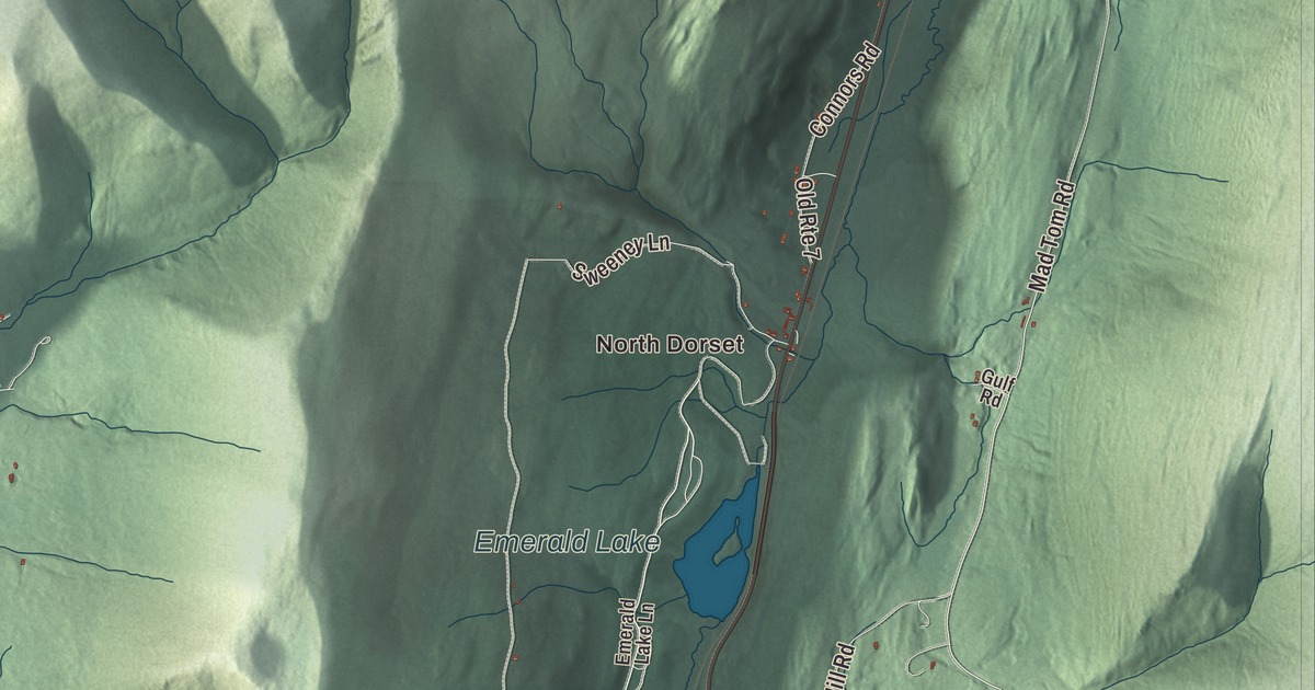
If you’re from Dorset, you know the town comes in two valleys: Dorset and South Dorset on Route 30 in the Taconics, and East Dorset, North Dorset and Freedleyville over in the Valley of Vermont. This map prints them all, along with Emerald Lake and South Village Pond and roads like Dorset West Road, Mad Tom Road, Dorset Hill Road and Upper Hollow Road.
Dorset is a town in Bennington County, Vermont.
KNOWOL made this map in 2026 from public survey data and gave it the look of an old county atlas. The mountains are shaded from United States Geological Survey elevation data, and the roads and town line come from the Census Bureau. Dorset covers 47.9 square miles, nearly all of it land, and it had 2,133 people at the 2020 census. Click here to purchase a print of this map for your wall.
Where the idea of Vermont was talked out
New Hampshire granted Dorset on August 20, 1761, and the town organized on March 3, 1774. It’s named for the English county of Dorset. Back then the land between the Connecticut River and New York was claimed by both New Hampshire and New York, and the settlers holding New Hampshire titles were told to buy their land again from New York or leave. Cephas Kent, born in Connecticut, brought his family to Dorset in 1773, served as a church deacon and kept a small tavern. In 1775 the settlers of the New Hampshire Grants held a convention at Kent’s tavern, and they met there three more times over the next year. On June 25, 1776, the convention voted to ask the people of the Grants to form “a separate district.” The agreements made in Kent’s tavern are known as the Dorset Accords, and that vote is described as the first official step toward Vermont’s independence. Windsor, where Vermont’s constitution was adopted in 1777, claims to be the state’s birthplace, but Dorset can say the idea was born here. Kent himself was Dorset’s first representative in the legislature, in March 1778.
The tavern stood in what’s now the Kent Neighborhood Historic District, centered where Dorset West Road meets Nichols Hill Road, south of the main village. There’s some disagreement about which old building was the tavern, and a marble memorial placed in 1912 marks the site. Most of the houses there are plain Federal-style homes built before 1850, many of them by members of the Kent family, and the oldest dates to about 1783.
Marble town
Dorset is described as the site of America’s oldest marble quarry. A quarry in East Dorset, started by Bill Wilson’s great-grandfather, stayed in the family for three generations, and its marble went into the main building of the New York Public Library. In Dorset village, some of the sidewalks along Church Street are paved with marble from local quarries, and the Congregational Church there is faced in it. The village is the Dorset Village Historic District, centered where Church Street and Kent Hill Road meet Route 30, and it takes in the Dorset Golf Links, founded in 1886 and one of the oldest golf courses in the nation. Over time the village center was overtaken in importance by East Dorset.
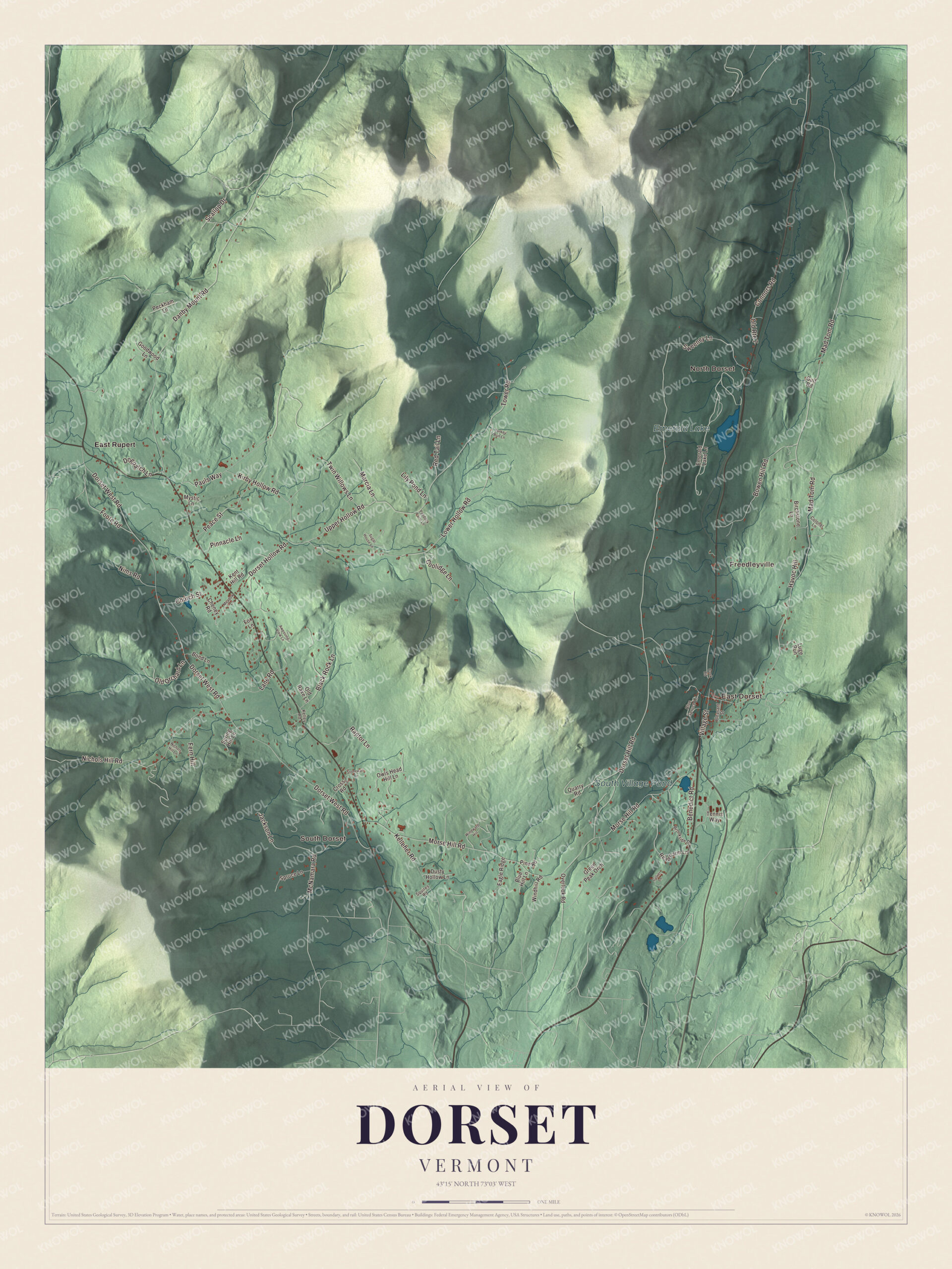
Click to explore a larger preview. The digital watermark does not appear on printed maps.
Names on this map
These names are printed on this map.
Places: North Dorset, South Dorset, East Dorset, Freedleyville, Emerald Lake, South Village Pond and East Rupert.
Streets and roads: Dorset Hill Road, Mad Tom Road, Lower Hollow Road, Tower Road, Upper Hollow Road, Dorset West Road, Morse Hill Road, Danby Mount Road, Kirby Hollow Road, Nichols Hill Road, Bowen Hill Road, McNamara Road.
More street names, A to Z
Awesome View Lane, Benedict Road, Birchstone Lane, Black Rock Lane, Blue Hill Lane, Blue Spruce Lane, Bond Lane, Brookside Drive, Cheney Road, Church Street, Colonel Lane, Connors Road, Cook Road, Coolidge Lane, Cross Road, Culver Lane, Dogpatch Lane, Dorset Hollow Road, Dusty Hollow Lane, Eagle Ridge, Emerald Lake Lane, Fern Hill, Foote Road, Fox Lane, Goodwood Lane, Green Peak Orch, Gulf Road, Havoc Hill, Jackson Lane, Kelleher Road, Kelley Road, Kent Hill Road, Lane Road, Lily Pond Lane, Luge Run, Marcia Lane, Meadow Lane, Mystic Lane, Nichols Hill Lane, Nims Road, Old Orchard Lane, Old Rake Lane, Old Route 7, Overlook Road, Owls Head Hill Lane, Paddock Farm Lane, Pauls Way, Peace Street, Peckham Lane, Pine Road, Pinnacle Lane, Pleasant Street, Quarry Road, Raptor Lane, Read Farm Lane, Red Tail Lane, Scallop Drive, Spring Hill Lane, Spruce Lane, Squires Road, Stonewall Lane, Sugar House Lane, Sweeney Lane, Tennis Way, Turkey Run Lane, Twin Willows Lane, Village Street, Windhill Road, Windward Hill.
See it on a wall
The Dorset map as a framed print. Swipe for more.


Bill W. and East Dorset
William Griffith Wilson, known to the world as Bill W., was born on November 26, 1895, in the hotel his family ran at the corner of Village Street and Mad Tom Road in East Dorset. He went on to co-found Alcoholics Anonymous. Bill and his sister Dorothy came back at age 11 to live with their grandparents, the Griffiths, and he met his future wife, Lois Burnham, while sailing on Emerald Lake in the summer of 1913. Built in 1852, the hotel is now the Bill Wilson House, a guest house and meeting place for people in recovery, and the nearby Griffith Library where he grew up is a museum and library in his memory. He’s buried close by.
Two rivers start almost side by side in this valley. The Batten Kill rises in East Dorset and flows south toward the Hudson, and Mad Tom Brook soon joins it. The Otter Creek rises a short way north and runs the other way, through Emerald Lake and on toward Lake Champlain. Emerald Lake State Park covers 430 acres around the 20-acre lake, which is named for its emerald color. Mount Aeolus rises to 3,230 feet between South Dorset and East Dorset.
On the map, follow Mad Tom Road, Dorset Hill Road, Tower Road, Upper Hollow Road and Lower Hollow Road, with Dorset West Road printed too. Look for North Dorset, South Dorset, East Dorset and Freedleyville. East Rupert is printed too. It’s a village in the next town over, on Route 30.
This map of Dorset is made for everyone who calls Dorset home and shows the town as it looks today, from Kent’s old neighborhood to Emerald Lake. Hang it in an office, library or den, or use it to teach children the geography and history of the town where Vermont’s independence was first talked out. KNOWOL created it in 2026, and it’s printed on museum quality archival paper. Zoom in on the preview above to explore the details, then click here to get your copy of the Dorset, Vermont map.

Sources
- Dorset, Vermont, Wikipedia
- Town histories and representatives, D towns, Vermont Legislature
- Kent Neighborhood Historic District, Wikipedia
- Dorset Village Historic District, Wikipedia
- Bill W., Wikipedia
- Bill Wilson House, Wikipedia
- Batten Kill, Wikipedia
- Otter Creek (Vermont), Wikipedia
- Emerald Lake State Park, Wikipedia
- Rupert, Vermont, Wikipedia