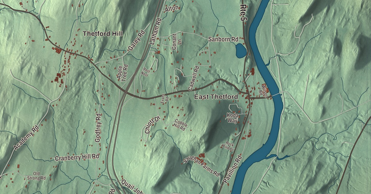
Thetford is a town of villages in the Connecticut River valley, among them East Thetford, North Thetford, Thetford Hill, Thetford Center, Rices Mills and Post Mills. This map prints those villages and Campbell Corner, along with Lake Fairlee, Lake Abenaki, Norford Lake and Mud Pond, and Robinson Hill Road, Norford Lake Road, Stowell Road, Hauger Road, Sawnee Bean Road and Main Street.
Thetford is a town in Orange County, Vermont.
KNOWOL made this map in 2026 from public survey data and gave it the look of an old county atlas, shading the hills from United States Geological Survey elevation data and drawing the roads and town line from the Census Bureau. The town covers 44.2 square miles, and 2,775 people lived here at the 2020 census. Click here to purchase a print of this map for your wall.
A duke’s title and an academy
Benning Wentworth, royal governor of New Hampshire, chartered Thetford on August 12, 1761, and named it for Augustus Henry Fitzroy, Duke of Grafton and Viscount Thetford, who became prime minister in 1768. John Chamberlin settled first, in 1764, at East Thetford beside the Connecticut River, as agent for one of the 62 proprietors, 51 of them from Hebron, Connecticut. The town organized on May 10, 1768, and it first sent a representative to the legislature in 1778. Interstate 91 crosses the town today, and at East Thetford the Lyme to East Thetford Bridge of 1937 crosses the Connecticut River where a ferry ran as early as 1780.
Thetford Hill grew up around the town meetinghouse, built between 1785 and 1788 and one of the state’s oldest churches in continuous use. It was moved off the common in 1830 and given its Greek Revival front. The village grew faster after 1819, when Thetford Academy was founded there, and it’s the oldest secondary school in Vermont. Its present buildings went up after 1942. Thetford Hill State Park, with facilities built in part by the Civilian Conservation Corps, lies just south of the campus. In 1910 the Camp Fire Girls began here, when the girls of Thetford, watching the boys practice for the town’s 150th anniversary, formed a group of their own, and within two years it became a national organization.
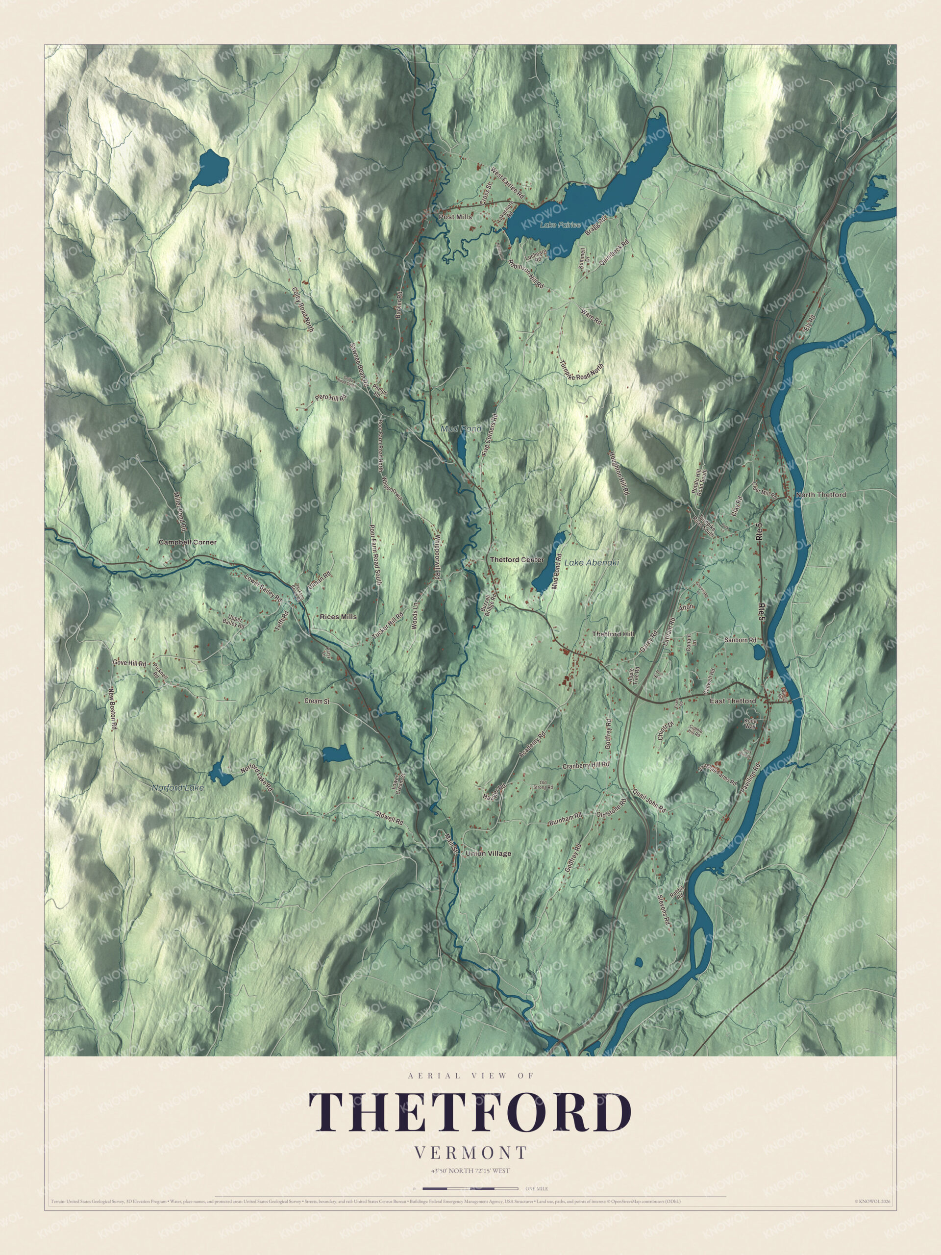
Click to explore a larger preview. The digital watermark does not appear on printed maps.
Names on this map
These names are printed on this map.
Places: East Thetford, Post Mills, North Thetford, Lake Abenaki, Norford Lake, Mud Pond, Lake Fairlee, Campbell Corner, Rices Mills, Thetford Center, Thetford Hill and Union Village.
Streets and roads: Route 5, Stowell Road, Norford Lake Road, Hauger Road, Robinson Hill Road, Main Street, Sawnee Bean Road, Academy Road, Godfrey Road, Gove Hill Road, Latham Road, Five Corners Road.
More street names, A to Z
Alton, Apple Tree Road, Barker Road, Bragg Road, Burnham Road, Buzzell Bridge Road, Cadwell Road, Chiott Drive, Cider Mill Road, Clay Road, Cobble Hill Road, Colby Road North, Colby Road South, Conant Lane, Cranberry Hill Road, Cream Street, Cross Street, Ely Road, Evans Road, Garey Road, Houghton Hill Road, Jackson Brook Road, Koda Way, Kummell Drive, Lakeshore Road, Lochearn Road, Lower Bailey Road, Lower Cream Street, Miller Pond Road, Mud Pond Road, New Boston Road, Norway Lane, Old Stone Road, Old Strong Road, Park Lane, Patsy Lane, Pavillion Road, Pero Hill Road, Phelps Road, Picknell Road, Poor Farm Road North, Poor Farm Road South, Potato Hill Road South, Quail John Road, Quinibeck Road, Rabbit Road, Rest Nest, Rock Pine Drive, Sanborn Road, Snowflake Lane, Stevens Road, Tefft Road, Tucker Hill Road, Turnpike Road North, Turnpike Road South, Ulman Road, Upper Bailey Road, Vaughan Farms Road, Ware Road, West Fairlee Road, Whippoorwill, Whippoorwill Road, Wilson Road, Woods Lane.
See it on a wall
The Thetford map as a framed print. Swipe for more.


Mills on the Ompompanoosuc
The Ompompanoosuc River flows south through town. Thetford Center began as a sawmill and gristmill on the river in 1772 and grew into a mill village making textiles and strawboard. Just west of the village, the Thetford Center Covered Bridge carries Tucker Hill Road over the river on the only known Haupt patent truss in Vermont. Downstream in Union Village, the Union Village Covered Bridge of 1867 is the state’s longest 19th-century multiple kingpost truss bridge. The essayist Noel Perrin bought a farm in Thetford Center in 1963, and it became his home and the material for six books, including First Person Rural.
Post Mills, in the north of town, has the Post Mills Church of 1818 on Route 244 near Robinson Hill Road, remodeled in 1855 and known for its rare late 1800s stencilwork inside. The Peabody Library of 1867 was a gift from the philanthropist George Peabody, who spent time here as a teenager with his grandfather, and it’s the oldest active library in the state’s federation of public libraries. In the late 1800s and early 1900s, the T. H. Chubb Rod Factory in Post Mills was the largest fishing rod factory in the country, and the old factory was torn down in 2010. Today the village airport keeps the Vermontasaurus, a dinosaur 122 feet long that Brian Boland and his volunteers built from scrap lumber in 2010. On Lake Fairlee, Camp Billings, founded in 1906, is believed to be the second-oldest active summer camp in Vermont.
Henry Wells, co-founder of Wells Fargo and American Express, was born in Thetford in 1805. Gustavus Loomis, born here, graduated from West Point in 1811 and rose to brigadier general, and the zoologist Dean Conant Worcester was born here in 1866. The writer Grace Paley spent summers in Thetford from the 1970s, settled here in the early 1990s and became Vermont’s state poet in 2003.
On the map, start with East Thetford and Post Mills, then follow Stowell Road, Norford Lake Road, Hauger Road, Robinson Hill Road, Main Street and Sawnee Bean Road across town. Then look outward toward North Thetford, Campbell Corner, Rices Mills, Thetford Center and Thetford Hill. Lake Abenaki, Norford Lake, Mud Pond and Lake Fairlee are printed too. Thetford dates to 1761.
This map of Thetford is made for everyone who calls Thetford home, and it shows the town as it looks today, from East Thetford and Thetford Hill to Post Mills and Lake Fairlee. Hang it in an office, library or den, or use it to teach children the geography and history of their town. It’s printed on museum quality archival paper. Zoom in on the preview above to explore the details, then click here to get your copy of the Thetford, Vermont map.

Sources
- Thetford, Vermont, Wikipedia
- Town histories and representatives, T towns, Vermont Legislature
- Lyme to East Thetford Bridge, Wikipedia
- Thetford Hill Historic District, Wikipedia
- Thetford Hill State Park, Wikipedia
- Camp Fire (organization), Wikipedia
- Thetford Center Historic District, Wikipedia
- Thetford Center Covered Bridge, Wikipedia
- Union Village Covered Bridge, Wikipedia
- Noel Perrin, Wikipedia
- Post Mills Church, Wikipedia
- Peabody Library (Thetford, Vermont), Wikipedia
- Post Mills, Vermont, Wikipedia
- Vermontasaurus, Wikipedia
- Camp Billings, Wikipedia
- Henry Wells, Wikipedia
- Gustavus Loomis, Wikipedia
- Dean Conant Worcester, Wikipedia
- Grace Paley, Wikipedia