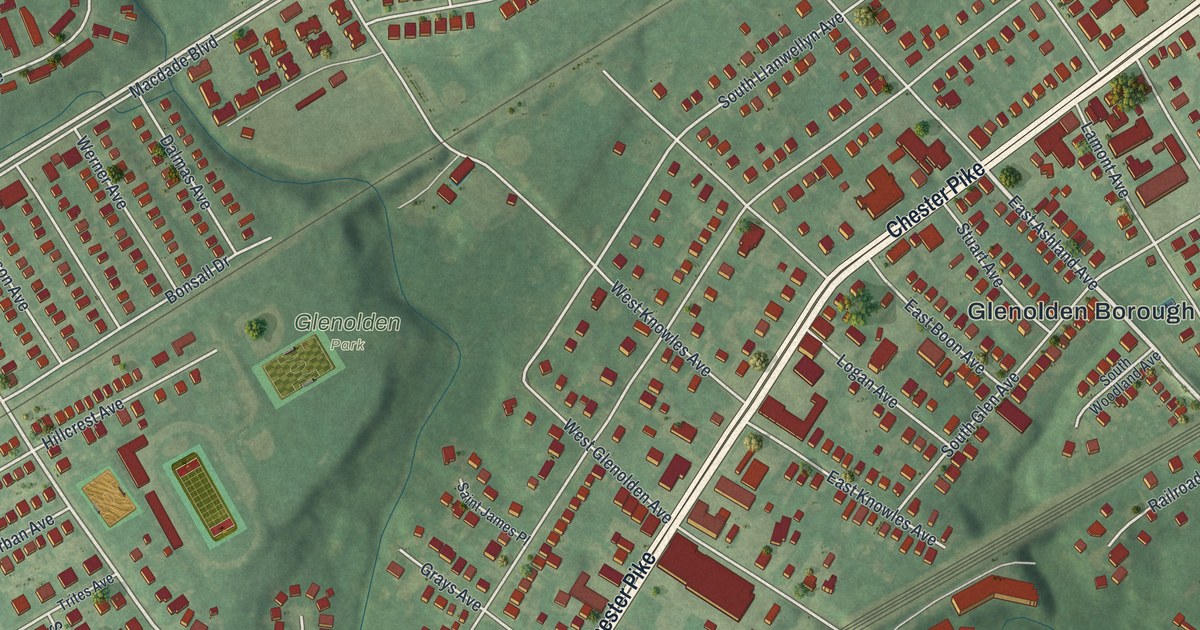
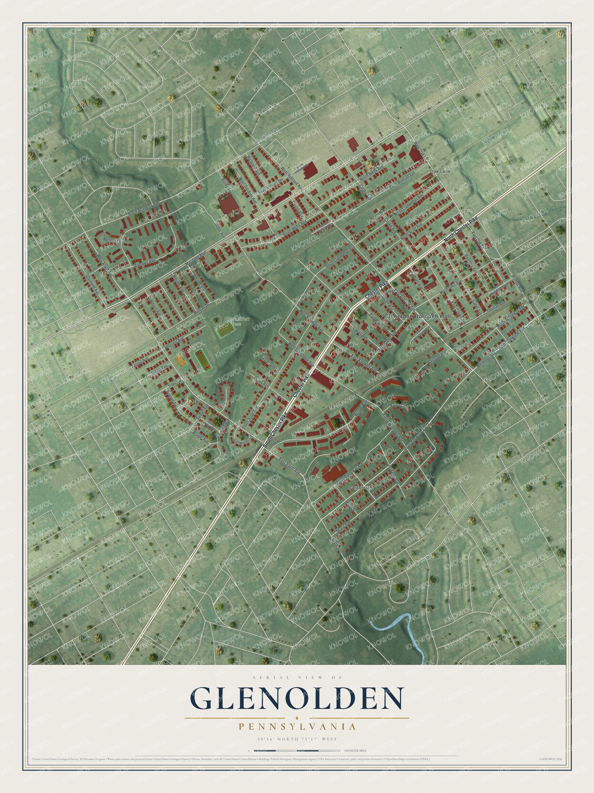
If you grew up in Glenolden, or your family still lives near Chester Pike, this print is a piece of home. It's a new aerial view of Glenolden in Delaware County, Pennsylvania, made from modern data with a vintage feel. Chester Pike crosses the middle as a wide pale line. Rows of small red shapes show the homes on each side of it. Glenolden Borough Hall and Glenolden Park sit near the center, with Oak Lane at the top and the Californian near the bottom.
Chester Pike, Once Called the King's Highway
On this map you'll find Chester Pike, Macdade Boulevard, Glenolden Borough Hall, Glenolden Park, Oak Lane, the Californian, East Ashland Avenue, South Avenue, Elmwood Avenue, North Llanwellyn Avenue, East Knowles Avenue, Hibbs Avenue, Primos Avenue, Railroad Avenue, and more. Each red shape is a building, so zoom in on the preview and look for yours.
Chester Pike is an old road. A state marker in Chester tells its story. Back in 1781, people called it the King's Highway. That September, French troops passed in review before Congress in Philadelphia. Then the French and American armies moved toward Wilmington by the Chester Pike. They camped in Chester on September 5, 1781. The marker names this the Rochambeau Route, from Narragansett Bay to Yorktown.
Glenolden Borough Hall and the Pike Today
Find the wide pale road on the preview. That's the same Chester Pike those armies used. Today red buildings line both sides of it. Glenolden Borough Hall stands close by, and Glenolden Park is just across the pike. The Census Bureau counted 7,223 people in the borough in 2020.
Glenolden Park, Oak Lane and the Blocks Between
Names on this map
These names are printed on this map.
Places: Glenolden Borough Hall, Glenolden Park, Californian and Oak Lane.
Streets and roads: South Chester Pike, North Chester Pike, Chester Pike, East Ashland Avenue, South Avenue, West Oak Lane, East Oak Lane, North Elmwood Avenue, East South Avenue, Macdade Boulevard, West South Avenue, South Elmwood Avenue.
More street names, A to Z
Andrews Avenue, Ashby Avenue, Benson Avenue, Benson Drive, Bonsall Drive, Bruner Avenue, Chestnut Street, Cooke Avenue, Custer Avenue, Dalmas Avenue, East Boon Avenue, East Cooke Avenue, East Glenolden Avenue, East Knowles Avenue, Elmwood Avenue, Glenfield Avenue, Glen Nor Avenue, Grays Avenue, Harrison Avenue, Hibbs Avenue, Hillcrest Avenue, Inskeep Avenue, Isabel Avenue, Karen Circle, Lamont Avenue, Logan Avenue, Lynwood Circle, North Andrews Avenue, North Bonsall Avenue, North Glen Avenue, North Llanwellyn Avenue, North Ridgeway Avenue, North Scott Avenue, North Wells Avenue, North Woodland Avenue, Primos Avenue, Railroad Avenue, Rambler Avenue, Richfield Avenue, Saint James Place, Serrill Street, Sharp Avenue, South Academy Avenue, South Andrews Avenue, South Bonsall Avenue, South Glen Avenue, South Llanwellyn Avenue, South Ridgeway Avenue, South Scott Avenue, South Wells Avenue, South Woodland Avenue, Sparks Circle, Stuart Avenue, Summit Avenue, Sylvan Avenue, Tatnall Avenue, Thomas Avenue, Trites Avenue, Urban Avenue, Werner Avenue, West Ashland Avenue, West Cooke Avenue, West Gardner Avenue, West Glenolden Avenue, West Knowles Avenue, Willow Way.
Created by KNOWOL in 2026, the print shows Glenolden from above in soft greens, with red buildings, pale roads and a small blue stream near the bottom. The title panel reads "Aerial View of Glenolden, Pennsylvania" with the coordinates 39°54' North 75°17' West.
It fits a living room, a front hall or a home office. It's a kind gift for someone who grew up near Glenolden Park and moved away. Open the preview and find your own block. See sizes and frames for the Glenolden map.