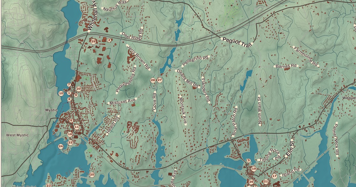
If you grew up in Stonington, or you’ve ever waited at the Mystic River Bascule Bridge while it lifted for a sailboat, you’ll find your town on this map just as it stands in 2026. Look for your road. Pequot Trail, Stonington Road, New London Turnpike, North Stonington Road, Pawcatuck Avenue, South Broad Street, West Vine Street, Mistuxet Avenue, Greenhaven Road, Barnes Road, Elm Street and Main Street are all printed by name, along with many more.
Stonington is in New London County, on Long Island Sound between the Mystic River and the Pawcatuck River, at the Rhode Island line.
KNOWOL made this map in 2026 from public survey data, and gave it the look of an old atlas. The shaded land, from the hills above Old Mystic down to the coves and points along the Sound, comes from United States Geological Survey elevation data. The streets and the town line come from the Census Bureau, right down to roads like Voluntown Road. Mystic, Old Mystic, Stonington, Lords Point, Wequetequock and Pawcatuck are printed by name. A guide of 34 numbered landmarks runs along the bottom, with the National Historic Landmarks and the National Register sites marked, and we checked those against National Park Service records.
The Stony Town
This was Pequot land, which they called Paquatuck and Mistack. Among the first English settlers were William Chesebrough and Walter Palmer at Wequetequock, Thomas Minor at Quiambaug and Thomas Stanton, who opened a trading house at Pawcatuck in 1649. Massachusetts named the place Southerton in 1658, and it became part of Connecticut in 1662, when Connecticut received its royal charter. The title panel prints that year: Incorporated 1662. It was renamed Mistick in 1665 and finally Stonington, the “stony town,” in 1666.
Stonington’s story is a seafaring one. From the 1790s its harbor was home to a fleet of sealing ships, and in November 1820 a young Stonington captain, Nathaniel Palmer, sighted the land in Antarctica that was named Palmer Land for him. In August 1814 a British squadron under Sir Thomas Hardy demanded the town’s surrender, and the selectmen answered, “We shall defend the place to the last extremity.” The town held out through three days of bombardment, and the two cannons that answered the British still stand in Cannon Square. Click here to learn more about the history of Stonington.
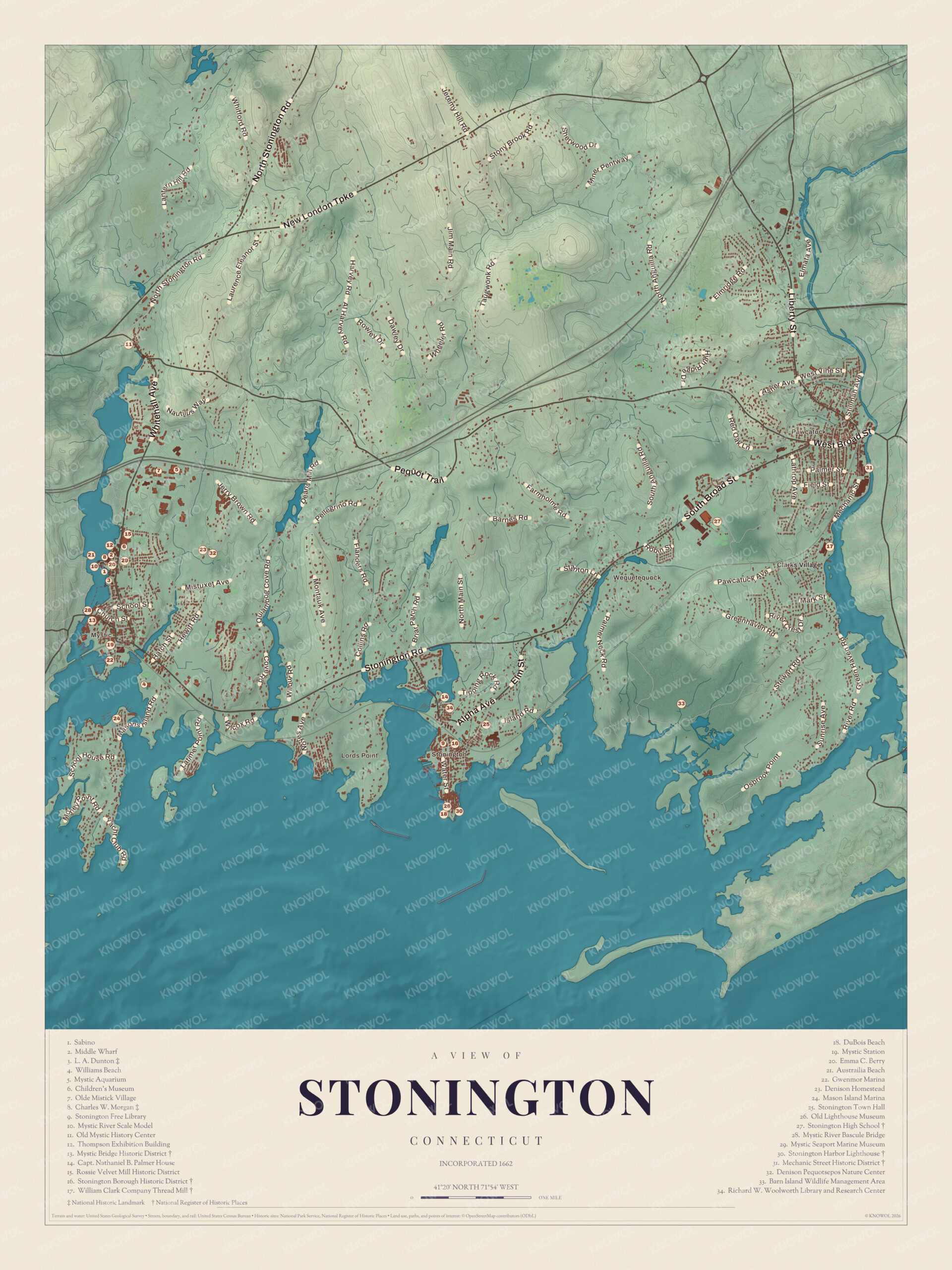
Click to explore a larger preview. The digital watermark does not appear on printed maps.
Names on this map
These names are printed on this map.
Places: Austrailia Beach, Barn Island Wildlife Management Area, CHARLES W. MORGAN, Clarks Village, Denison Homestead, Denison Pequotsepos Nature Center, DuBois Beach, Gwenmor Marina, L. A. DUNTON, Lords Point, Mason Island Marina, Mechanic Street Historic District, Middle Wharf, Mystic Aquarium, Mystic Bridge Historic District, Mystic Seaport Marine Museum, North Stonington Town Hall, Old Lighthouse Museum, Old Mystic, Olde Mistick Village, Palmer Street, Richard W. Woolworth Library and Research Center, Rossie Velvet Mill Historic District, Stonington Borough Historic District, Stonington Harbor Lighthouse, Stonington High School, William Clark Company Thread Mill and Williams Beach.
Streets and roads: Harvey Rd, Maine Rd, Vine St, School St, Barnes Rd, Pequot Ct, Neck Rd, Palmer St, Mark St, Greenhaven Rd, Green Ave and Sunrise Ave.
Mystic Seaport
On the west side of town, along the Mystic River, is the busiest cluster of numbers on the map. The village of Mystic is split between Stonington and Groton, and the shipyards were mostly on this, the eastern, side. The Greenman brothers built ships here from the 1840s to the 1890s, and their shipyard is now the grounds of Mystic Seaport Marine Museum (29), founded in 1929 and the largest maritime museum in the United States. Its 19 acres hold a re-created seaport village of more than 60 old buildings, with a ropewalk, sail loft, cooperage and chandlery, and the guide numbers several of its treasures one by one.
The Charles W. Morgan (8) is a whaling ship built in New Bedford in 1841. She’s the world’s oldest surviving merchant vessel and the only surviving wooden whaling ship from the American merchant fleet of the 1800s, and the museum has had her since 1941. Beside her are the L. A. Dunton (3), a fishing schooner of 1921, one of three of her type still afloat; the Emma C. Berry (20), a fishing sloop built at Noank in 1866, the last known American well smack; and the Sabino (1), a wooden coal-fired steamboat of 1908, called America’s oldest regularly operating coal-powered steamboat. All four are National Historic Landmarks. The museum also has a 40-foot model of the Mystic River as it looked around 1870, down to the outhouses behind the houses, which the guide lists as the Mystic River Scale Model (10). The guide also lists the Middle Wharf (2), the Thompson Exhibition Building (12) and the Children’s Museum (6) here.
Just north of the museum is the Rossie Velvet Mill Historic District (15). In 1897 velvet makers from Germany opened a mill here, and it became the village’s largest employer, with 200 workers, until it closed for good in 1958. Today the old brick mill is a research center for the museum. South of the museum, the Mystic Bridge Historic District (13) covers the old shipbuilding village on the Stonington side, and the Mystic River Bascule Bridge (28) carries Main Street across the river. Built in the early 1920s, it lifts for boats about 2,200 times a year, and in summer it opens every hour at 40 minutes past. Mystic Station (19), built in 1905, was the model for American Flyer toy train stations for more than 50 years. Williams Beach (4) is south of the village.
Around Mystic
Northeast of the seaport are Mystic Aquarium (5), which opened in 1973 and has the only beluga whales in New England, and Olde Mistick Village (7). A short way south is the Denison Homestead (23), a house of 1717 on land that has belonged to the Denison family since 1654, and next to it the Denison Pequotsepos Nature Center (32). Part of Old Mystic, which is mostly in Groton, is in Stonington too, and the guide lists the Old Mystic History Center (11). At the mouth of the Mystic River is Mason’s Island, named for Major John Mason, joined to the mainland by a causeway, with the Mason Island Marina (24) at its north end. The guide also lists the Gwenmor Marina (22).
Stonington Borough
On a point of land reaching into Little Narragansett Bay is the Borough, the old village of Stonington. The guide marks it as the Stonington Borough Historic District (16). Its two main streets join Cannon Square and Wadawanuck Square, and its colonial, Federal and Greek Revival houses have kept their looks with no heavy traffic or modern industry, and with the Borough’s long life as a fashionable summer place. It’s still home to one of Connecticut’s last fishing and lobstering fleets, and to a large community of Portuguese descent, many of whose families came from the Azores on whaling ships. The Stonington Free Library (9) is in the Borough, and Stonington Town Hall (25) is just northeast of it.
At the southern tip of Stonington Point is the Stonington Harbor Lighthouse (30), a stone tower and keeper’s house of 1840, built with stones from an earlier lighthouse. It went dark in 1889, and since 1925 the Stonington Historical Society has run it as a museum, which makes it the oldest lighthouse museum in America. The guide lists the museum a second time as the Old Lighthouse Museum (26). DuBois Beach (18) is right beside it.
North of the Borough, on a point between two coves, is the Capt. Nathaniel B. Palmer House (14), built in 1852 to 1854 for the Antarctic explorer, who went on to design clipper ships. The Historical Society saved it from demolition in 1995, and it’s a National Historic Landmark. Near it are the Richard W. Woolworth Library and Research Center (34) and the Historical Society Library.
Pawcatuck and Barn Island
In the east, across the Pawcatuck River from Westerly, Rhode Island, is Pawcatuck. Its shipyards came first, then the railroad in 1837, and with it a foundry, a printing press works and textile mills. The Mechanic Street Historic District (31) is its old mill village, a 147-acre neighborhood of worker housing beside a big brick mill complex on the river. South of it is the William Clark Company Thread Mill (17), begun in 1892, a brick mill with a square tower overlooking the river. Stonington High School (27), built in Pawcatuck in 1939, is to the west. The guide’s Register mark belongs to the old Borough School of 1888 on Orchard Street, which was Stonington High School from 1910 to 1939. Barn Island Wildlife Management Area (33) is to the southeast, and the guide also lists Australia Beach (21).
This map of Stonington makes a handsome addition to a living room, office, library or den, and it can even help teach children the geography and history of the town. It’s a thoughtful gift for anyone who calls Stonington home, grew up here, or moved away. Created by KNOWOL in 2026, it’s printed on museum quality archival paper in three sizes. Zoom in on the preview above to explore the details, then click here to get your copy of the Stonington map.

Sources
- Stonington, Connecticut, Wikipedia
- Stonington, ConnecticutHistory.org
- Mystic Seaport, Wikipedia
- Charles W. Morgan (ship), Wikipedia
- L. A. Dunton (schooner), Wikipedia
- Emma C. Berry (sloop), Wikipedia
- Sabino (steamer), Wikipedia
- Rossie Velvet Mill Historic District, Wikipedia
- Mystic Bridge Historic District, Wikipedia
- Mystic River Bascule Bridge, Wikipedia
- Mystic station, Wikipedia
- Mystic Aquarium, Wikipedia
- Pequotsepos Manor (Denison Homestead), Wikipedia
- Old Mystic, Connecticut, Wikipedia
- Mason’s Island, Wikipedia
- Stonington (borough), Connecticut, Wikipedia
- Stonington Harbor Light, Wikipedia
- Stonington Harbor Light, National Register nomination, National Park Service
- Capt. Nathaniel B. Palmer House, Wikipedia
- Pawcatuck, Connecticut, Wikipedia
- Mechanic Street Historic District, Wikipedia
- William Clark Company Thread Mill, Wikipedia
- Stonington Borough School, Wikipedia