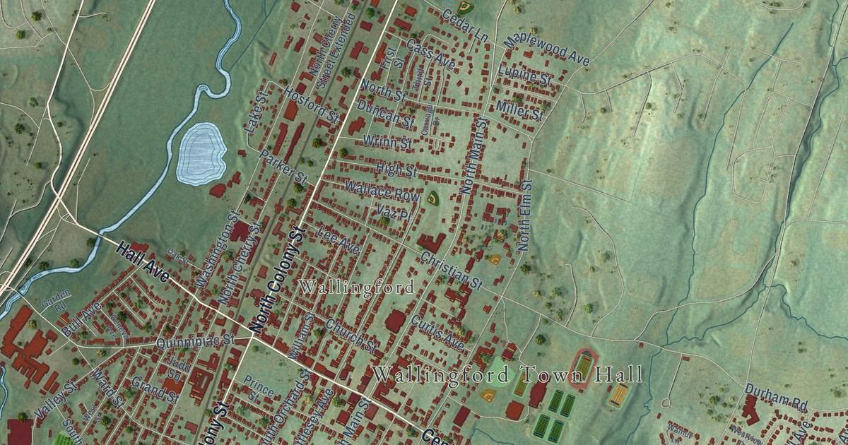
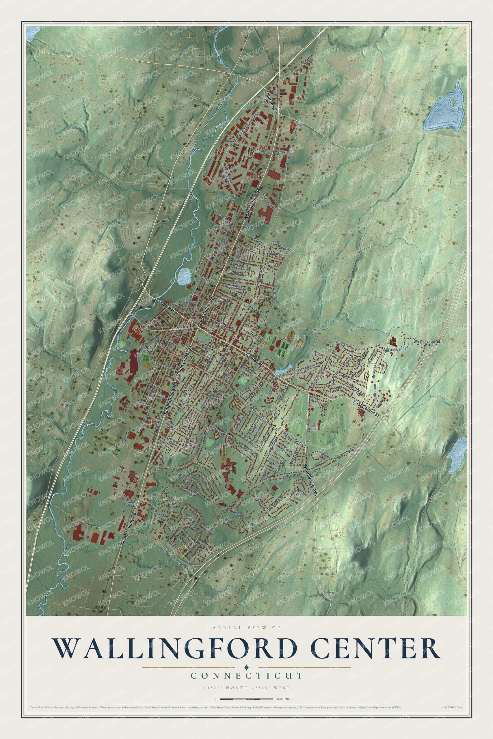
This beautifully detailed map of Wallingford Center, Connecticut was created in 2026 using aerial imagery combined with modern topographical, census, street and landmark data. It's a modern aerial view of Wallingford Center in South Central Connecticut Planning Region, Connecticut, that combines modern data with a vintage aesthetic. The roads feature printed names, and if you look closely you can find your exact house accurately shown in its correct location.
Explore an aerial view of Wallingford Center, Connecticut
On this map you'll find Wallingford Town Hall, Quinnipiac, Wallingford, North Colony Road, North Colony Street, Hall Avenue, Center Street, Woodhouse Avenue, East Center Street, South Colony Road, South Colony Street, Church Street, and more. Each red shape is a building, so zoom in on the preview and look for yours.
Wallingford Center is a community in South Central Connecticut Planning Region. The Census Bureau counted 18,278 people here in 2020. Wallingford Center sits about 4 miles northwest of Northford, 4 miles northeast of Quinnipiac University and 5 miles northeast of North Haven. The map prints the town name in its title panel, with the coordinates below it.
Take a closer look at the Wallingford Center map
Names on this map
These names are printed on this map.
Places: Wallingford Town Hall, Quinnipiac and Wallingford.
Streets and roads: North Colony Road, North Colony Street, Hall Avenue, Center Street, Woodhouse Avenue, East Center Street, South Colony Road, South Colony Street, Church Street, North Main Street Extended, North Main Street, Quinnipiac Street.
More street names, A to Z
Anna Drive, Audette Drive, Backes Court, Balsam Road, Bayberry Drive, Beaumont Road, Birch Drive, Blakeslee Road, Brian Road, Bruce Lane, Buel Street, Bull Avenue, Burke Heights Drive, Capitol Drive, Cardinal Drive, Carriage Drive, Carr Street, Cass Avenue, Cedar Lane, Cedar Street, Charben Lane, Cheryl Avenue, Christian Street, Christoni Lane, Clifton Street, Concord Lane, Constitution Street, Cooper Avenue, Country Club Lane, Croydon Court, Curtis Avenue, Dannys Way, Docker Drive, Doolittle Crossing, Dudley Avenue, Duncan Street, Durham Road, East Main Street, East Side Drive, East Street, Eaton Drive, Elika Road, Elm Hill Drive, Fair Street, Fairview Avenue, Field Drive, First Street, Florence Avenue, Garden Road, Geneva Avenue, Grand Street, Grandview Avenue, Grantham Road, Green Street, Harrison Avenue, Harrison Road, Henry Street, High Street, Holly Lane, Hosford Street, Ives Road, Ivy Street, John Street, Judd Square, Kingsland Avenue, Kondracki Lane, Lake Street, Laura Jane Drive, Laurel Drive, Lee Avenue, Lendler Lane, Lincoln Avenue, Lincoln Drive, Londonderry Drive, Long Hill Road, Louis Circle, Lupine Street, Maplewood Avenue, Mariot Circle, Marshall Street, Martin Avenue, Mary Ann Lane, McGuire Court, McKenzie Avenue, Megan Lane, Mellor Drive, Miller Street, Morningside Terrace, New Rock Hill Road, Nichols Street, Norman Avenue, North Cherry Street, North Cherry Street Extended, North Elm Street, Northfield Road, North Plains Highway, North Plains Industrial Highway, North Plains Industrial Road, North Street, Oak Street, Old Colony Road, Old Rock Hill Road, Parker Street, Park Lane, Parsons Street, Pent Highway, Pent Road, Pine Street, Pogmore Drive, Pond Hill Road, Prince Street, Putter Drive, Reskin Drive, Saw Mill Drive, Shady Drive, Sigwin Circle, Simpson Avenue, Sorrento Road, South Airline Road, South Cherry Street, South Elm Street, South Main Street, South Orchard Street, South Side Drive, South Street, South Whittlesey Avenue, Southwind Drive, Stillwood Road, Summit Drive, Sunny Court, Surrey Drive, Sylvan Avenue, Sylvan Way, Terrace Gardens, Third Street, Toelles Road, Tremper Drive, Valley Street, Vaz Place, Wallace Row, Wall Street, Walnut Lane, Ward Street, Ward Street Extended, Washington Street, West Street, Westview Drive, Wharton Brook Con, Wharton Brook Drive, Willard Avenue, Williams Place, William Street, Wrinn Street, Yale Avenue.
Created by KNOWOL in 2026. The buildings are small red shapes, the roads carry their printed names, and shaded relief shows the shape of the land. The title panel reads "AERIAL VIEW OF WALLINGFORD CENTER, CONNECTICUT" with 41°27' NORTH 72°49' WEST.
Hang it in the hallway, the office or the cabin, or give it to someone who left Wallingford Center and still calls it home. Open the preview and look for a street you know. See sizes and frames for the Wallingford Center map.