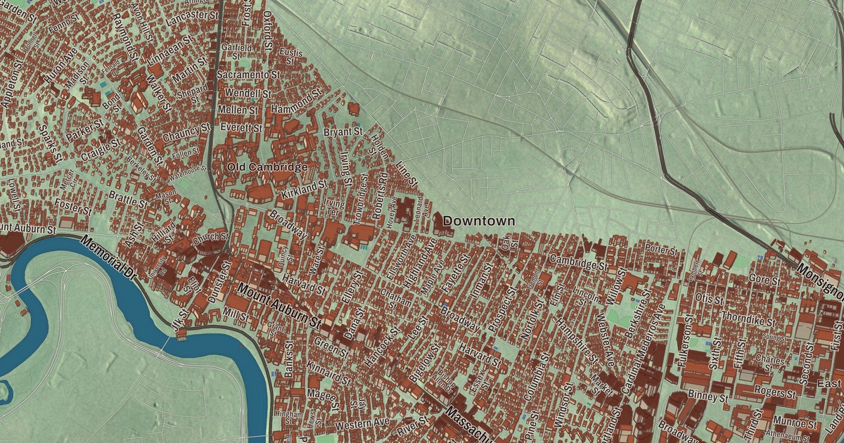
Cambridge has been called the City of Squares, and people here steer by Harvard, Central, Kendall, Inman and Porter, and by the river, with Memorial Drive along the Charles and Fresh Pond out west. This map prints Memorial Drive, Mount Auburn Street, Main Street, Fresh Pond Parkway, Alewife Brook Parkway and Monsignor Obrien Highway, with Fresh Pond, Jerrys Pond, Avon Hill, Coolidge Hill, Huron Village and Alewife Brook. Click here to purchase a print of this map for your wall.
Cambridge is in Middlesex County, directly across the Charles River from Boston.
KNOWOL made this map in 2026 from public survey data and gave it the look of an old atlas. The relief comes from United States Geological Survey elevation data, and the streets and the city line come from the Census Bureau. Cambridge covers 7.1 square miles, almost a tenth of it water, with Boston to the south and east, Somerville to the north, Arlington to the northwest and Belmont and Watertown to the west. It’s the most populous city in the county, with 118,403 people at the 2020 census, the fourth-largest in Massachusetts.
Newtowne
Native people lived along the Charles for thousands of years before the English came. The City of Cambridge’s recorded history, in the Secretary of the Commonwealth’s list, dates European settlement to 1630. That December the site was chosen because it lay safely upriver from Boston Harbor, and Thomas Dudley, his daughter Anne Bradstreet and his son-in-law Simon Bradstreet founded it; the first houses went up in the spring of 1631. The settlers called it the “newe towne.” It sat at the first convenient Charles River crossing west of Boston, and the original village is now inside Harvard Square. Cambridge was incorporated as a town in 1636, and in May 1638 Newtowne took the name Cambridge, in honor of the University of Cambridge in England, an important center of the Puritan theology its founders embraced. In 1639 the General Court bought the land from the Squaw Sachem of Mistick. Cambridge was incorporated as a city in 1846.
The town was much bigger at first. Its outlying parts became Newton, Lexington, Brighton and Arlington, and later plans to annex Cambridge to Boston were all turned down.
The college, the Common and the army
In 1636 the colony founded a college here, first called Newe College and later Harvard College after its benefactor John Harvard. Harvard is the oldest institution of higher learning in the United States. Cambridge Common, set aside in 1630 as pasture, woodlot and training ground, filled with patriot soldiers after the Battles of Lexington and Concord, and in July 1775 George Washington arrived there to take command of the new Continental Army. The Common is celebrated as the army’s birthplace. Washington made his headquarters in the Vassall house at 105 Brattle Street from July 1775 to April 1776, during the Siege of Boston, and on January 24, 1776, Henry Knox reached Cambridge with the artillery from Fort Ticonderoga that forced the British to leave Boston. Brattle Street, once lined with the mansions of a small Anglican elite, is still known as Tory Row.
Poets, teachers and a garden cemetery
The Vassall house later became Henry Wadsworth Longfellow’s home for almost 50 years, and it’s now a National Historic Site honoring both Longfellow and Washington’s headquarters. In the mid-1800s Cambridge was the home of the Fireside poets, Longfellow, James Russell Lowell and Oliver Wendell Holmes, whose poems families read aloud by the evening fire. Out on Mount Auburn Street, Mount Auburn Cemetery was dedicated in 1831 as the first rural or garden cemetery in the United States, a landscaped arboretum that inspired cemetery designers from Brooklyn to London; much of it lies in Watertown.
Maria Louise Baldwin, born and raised in Cambridge, wasn’t hired by the city’s schools at first and taught in Maryland. After protests from Cambridge’s African American community she was hired at the Agassiz School, and in 1889 she became its principal, the first African American woman principal in Massachusetts and the Northeast. She led the school for forty years, and the poet E. E. Cummings, one of her pupils, wrote that from her he learned “the truest power is gentleness.” In 2021 the neighborhood around the school was renamed Baldwin in her honor.
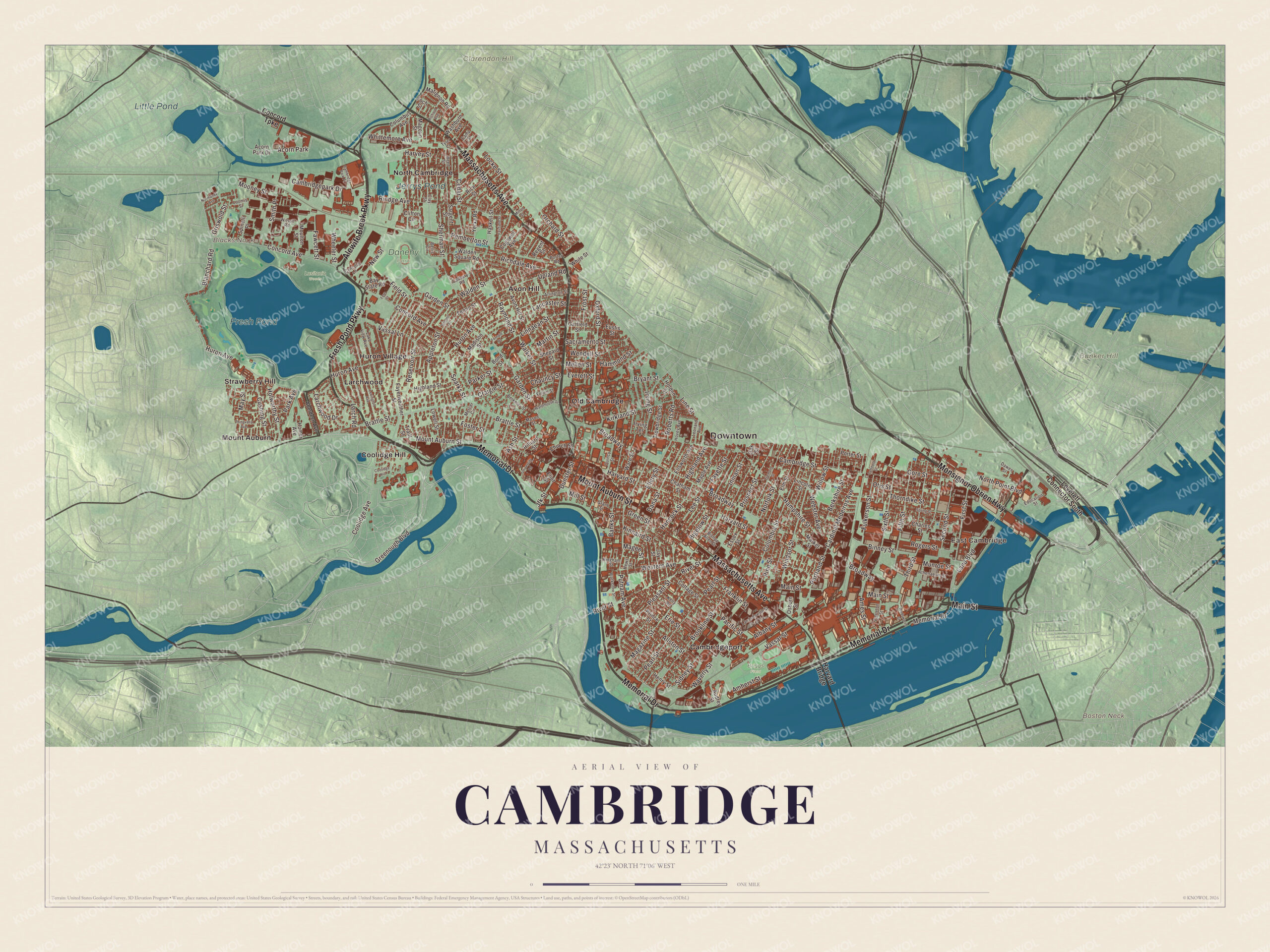
Click to explore a larger preview. The digital watermark does not appear on printed maps.
Names on this map
These names are printed on this map.
Places: Downtown, East Cambridge, Boston Neck, Bunker Hill, Clarendon Hill, Blacks Nook, Fresh Pond, Little Pond, Jerrys Pond, Briggs Field, Danehy Park, Lusitania Woods, Avon Hill, Cambridgeport, Coolidge Hill, Huron Village, Larchwood, Mount Auburn, North Cambridge, Old Cambridge, Strawberry Hill and Acorn Park.
Streets and roads: Memorial Drive, Fresh Pond Parkway, Mount Auburn Street, Monsignor Obrien Highway, Main Street, Alewife Brook Parkway, Massachusetts Avenue, Land Boulevard, Broadway, Brattle Street, Jfk Street, Whittemore Avenue.
More street names, A to Z
Aberdeen Avenue, Acorn Park Drive, Albany Street, Allston Street, Ames Street, Amherst Street, Appleton Street, Arlington Street, Ash Street, Athenaeum Street, Audrey Street, Avon Hill Street, Banks Street, Bay State Road, Bellis Circle, Berkeley Street, Berkshire Street, Bigelow Street, Binney Street, Bishop Allen Drive, Blackstone Street, Blanchard Road, Bond Street, Brookline Street, Bryant Street, Cadbury Road, Cambridgepark Drive, Cambridge Park Place, Cambridge Street, Camp Street, Cardinal Medeiros Avenue, Carleton Street, Cedar Street, Charles Street, Chatham Street, Chauncy Street, Church Street, Clay Street, Clifton Circle, Cogswell Avenue, Columbia Street, Columbus Avenue, Concord Avenue, Concord Lane, Concord Turnpike, Coolidge Avenue, Cottage Street, Craigie Street, Cushing Street, Dana Street, Dawes Street, Donnell Street, Dunster Street, Education Street, Eliot Street, Ellery Street, Ellsworth Avenue, Elm Street, Erie Street, Essex Street, Eustis Street, Everett Street, Fairfield Street, Fawcett Street, Fayerweather Street, Fayette Street, Fenno Street, Fernald Drive, Fern Street, Field Street, Fifth Street, First Street, Foch Street, Follen Street, Foster Street, Franklin Street, Frost Street, Fulkerson Street, Garden Street, Garfield Street, Gore Street, Grant Street, Greenough Boulevard, Green Street, Griswold Street, Hammond Street, Hampshire Street, Hancock Street, Harvard Bridge, Harvard Street, Harvey Street, Haskell Street, Henry Street, Hews Street, Highland Avenue, Highland Street, Hilliard Street, Hingham Street, Holden Street, Holworthy Street, Homer Avenue, Hovey Avenue, Huron Avenue, Inman Street, Irving Street, Irving Terrace, Jay Street, Kelly Road, Kinnaird Street, Kirkland Street, Lake View Avenue, Lambert Street, Lancaster Street, Landsdowne Street, Larch Road, Larchwood Drive, Lee Street, Leonard Avenue, Leverett Connector South, Lexington Avenue, Lincoln Street, Line Street, Linnaean Street, Locke Street, Loomis Street, Lowell Street, Madison Street, Magazine Street, Magee Street, Magoun Street, Maple Avenue, Market Street, Martin Street, Mason Street, Matignon Road, May Street, Mellen Street, Mercer Circle, Mill Street, Milton Street, Mooney Street, Moulton Street, Munroe Street, New Street, Norfolk Street, Normandy Avenue, North Point Boulevard, Oak Street, Orchard Street, Osborn Street, Otis Street, Oxford Street, Pacific Street, Park Avenue, Parker Street, Pearl Street, Pemberton Street, Pine Street, Pleasant Street, Porter Road, Porter Street, Portland Street, Prince Street, Prospect Street, Putnam Avenue, Quincy Street, Raymond Street, Reed Street, Regent Street, Reservoir Street, Rice Street, Richard Avenue, Richdale Avenue, Rindge Avenue, River Street, Roberts Road, Rogers Street, Sacramento Street, Sargent Street, Second Street, Shepard Street, Sherman Street, Sidney Street, Sixth Street, Smith Place, Sparks Street, Spinelli Place, Spring Street, Thingvalla Avenue, Third Street, Thorndike Street, Traill Street, Tremont Street, Trowbridge Street, Tyler Court, University Road, Upland Road, Vassal Lane, Vassar Street, Wadsworth Street, Walden Square Road, Walden Street, Walker Street, Ware Street, Washburn Avenue, Waterhouse Street, Waverly Street, Webster Avenue, Wendell Street, Western Avenue, Wheeler Street, White Street, Willow Street, Wilson Road, Windsor Street, Yerxa Road.
Ice, glass, candy and email
Bridges to Boston in 1792 and 1809 turned marsh and estates into industrial neighborhoods. Ice cut on Fresh Pond by Boston’s “Ice King,” Frederic Tudor, and others was shipped as far as Europe, China and India. The New England Glass Company, founded in 1818, was by the middle of the century the world’s largest and most modern glassworks. Main Street became “Confectioner’s Row,” home to candy makers like James O. Welch, maker of Junior Mints, and Junior Mints are still made in the old Welch factory on Main Street today. The Fig Newton was first made in Cambridgeport in 1891.
Radcliffe College opened in 1879, and in 1916 MIT moved across the river from Boston. In Cambridge Highlands the firm of Bolt, Beranek and Newman built the first network router in 1969 and hosted the invention of computer-to-computer email in 1971. VisiCalc, the first spreadsheet for personal computers, came from a Cambridge company, and Kendall Square, at the eastern end of MIT, has been called “the most innovative square mile on the planet.” At least 258 Nobel Prize winners have been affiliated with universities in Cambridge.
Around the map
Start in East Cambridge, once an island at high tide in the marshes, then follow Memorial Drive, Fresh Pond Parkway, Mount Auburn Street, Monsignor Obrien Highway, Main Street and Alewife Brook Parkway across the city, and look outward toward Avon Hill, Cambridgeport, Coolidge Hill, Huron Village and Larchwood. Memorial Drive, begun in 1897 as Charles River Road, was renamed in 1923 for the Massachusetts soldiers of World War I. Fresh Pond, a 155-acre kettle hole lake, has been the city’s water supply since the city took over the waterworks in 1865, with a 2.25-mile path around it. Jerrys Pond in North Cambridge was a clay pit for the brickyards, once called Jerry’s Pit, and a friends group formed in 2015 works to restore it. Avon Hill, first called Jones Hill, holds some of the finest Victorian houses in the city. Little Pond is one of the ponds of the Alewife Brook Reservation. Bunker Hill lies across the river in Charlestown, and Boston Neck, the old strip of land that tied Boston to Roxbury, is now part of the South End. Fresh Pond, Little Pond, Jerrys Pond, Bunker Hill, Clarendon Hill and Boston Neck are all printed on the map.
Cambridge’s map makes a fine addition to an office, library or den, and it can help teach children the geography and history of the city where the Continental Army began. It’s made for people who call Cambridge home, from Cambridgeport to Huron Village, and it shows the city as it looks today. Zoom in on the preview above to explore the details, then click here to get your copy of the Cambridge, Massachusetts map.

We made a map for every town and city in Massachusetts. Explore the complete Massachusetts map collection and find your town.
Sources
- Cambridge, Massachusetts, Wikipedia
- Cambridge Common, Wikipedia
- Longfellow House, Washington’s Headquarters National Historic Site, Wikipedia
- Tory Row, Wikipedia
- Fireside poets, Wikipedia
- Mount Auburn Cemetery, Wikipedia
- Maria Louise Baldwin, Wikipedia
- Fresh Pond (Cambridge, Massachusetts), Wikipedia
- Cambridgeport, Wikipedia
- East Cambridge, Wikipedia
- Memorial Drive (Cambridge), Wikipedia
- Jerry’s Pond, Wikipedia
- Avon Hill Historic District, Wikipedia
- Alewife Brook Reservation, Wikipedia
- Bunker Hill, Wikipedia
- Boston Neck, Wikipedia
- City and Town Incorporation and Settlement Dates, Secretary of the Commonwealth of Massachusetts (archived copy)