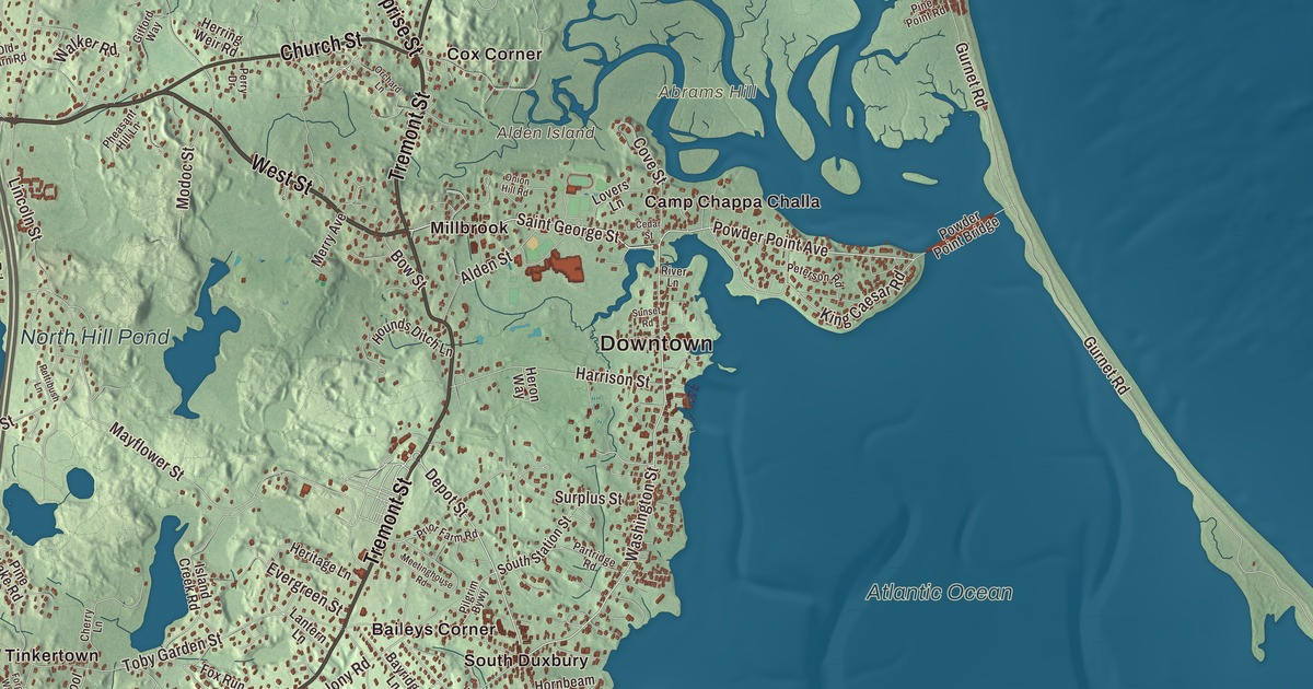
Duxbury is the Pilgrim town on the bay north of Plymouth, where Myles Standish and John Alden made their homes, and where the long wooden Powder Point Bridge still carries you out to Duxbury Beach. This map prints Congress Street, West Street, Tremont Street, Summer Street, Kingstown Way and Church Street, with Island Creek, Alden Island, Arnold Reservoir, Stump Pond, North Hill Pond and Abrams Hill. Click here to purchase a print of this map for your wall.
Duxbury is in Plymouth County, on the South Shore about 35 miles southeast of Boston.
KNOWOL made this map in 2026 from public survey data and gave it the look of an old atlas. The relief comes from United States Geological Survey elevation data, and the roads and the town line come from the Census Bureau. Duxbury covers 37.6 square miles, more than a third of it water, with Cape Cod Bay to the east, Duxbury Bay and Kingston Bay to the southeast, Kingston to the southwest, Pembroke to the west and Marshfield to the north. The town had 16,090 people at the 2020 census.
Mattakeesett
The Wampanoag called this shore Mattakeesett, “place of many fish.” The Pilgrims settled at nearby Plymouth in 1620, and when their seven-year contract with their London backers ran out in 1627, the coast from Plymouth to Marshfield was divided into farms. At first the settlers worked their Duxbury land in the warm months and went back to Plymouth for the winter, but soon they built homes and asked to become a separate community with their own church. The Town of Duxbury’s recorded history, in the Secretary of the Commonwealth’s list, dates European settlement to 1624. Duxbury, which then took in today’s Pembroke, was incorporated as a town in 1637, and the town remains part of Plymouth County today. The name likely comes from Duxbury Hall in Chorley, the ancestral home of Myles Standish in England.
Some of the colony’s leading men lived here. Captain Myles Standish, its military leader, lived at “the Nook,” now called Standish Shore, and Elder William Brewster led the colony’s services for years. John Alden, who came over on the Mayflower, is remembered at two sites now listed together as a National Historic Landmark: the foundation of the house he built around 1630, near the Bluefish River, and the Alden House on Alden Street, which the town’s page dates to 1653 and a forensic study dates to around 1700, probably the work of his grandson. Longfellow’s poem The Courtship of Miles Standish made Alden and Priscilla Mullins part of American folklore. Graves of some of the first settlers are in the Old Burying Ground on Chestnut Street, and Standish rests in the Myles Standish Burial Ground under a small monument of his own.
King Caesar’s shipyards
After the Revolution, Duxbury families began building big fishing schooners for the Grand Banks, and then brigs and three-masted ships. By 1837 nearly 40 shipyards lined the west shore of Duxbury Bay between Captain’s Hill and the mouth of the Bluefish River, backed by a foundry, a sail loft and a ropewalk. The largest business belonged to Ezra Weston, who began building small boats on Powder Point in 1764 and was known as “King Caesar”; his son Ezra Weston II took the name and the firm to its height. In 1841 Daniel Webster called the younger Weston “the largest ship owner, probably, in the United States.” His Federal-style King Caesar House, finished in 1809, is now a museum run by the Duxbury Rural and Historical Society. When deep-draft clippers and steamships took over, the shallow bay couldn’t build them, and the town declined until summer visitors arrived in the 1870s on the new Duxbury & Cohasset Railroad.
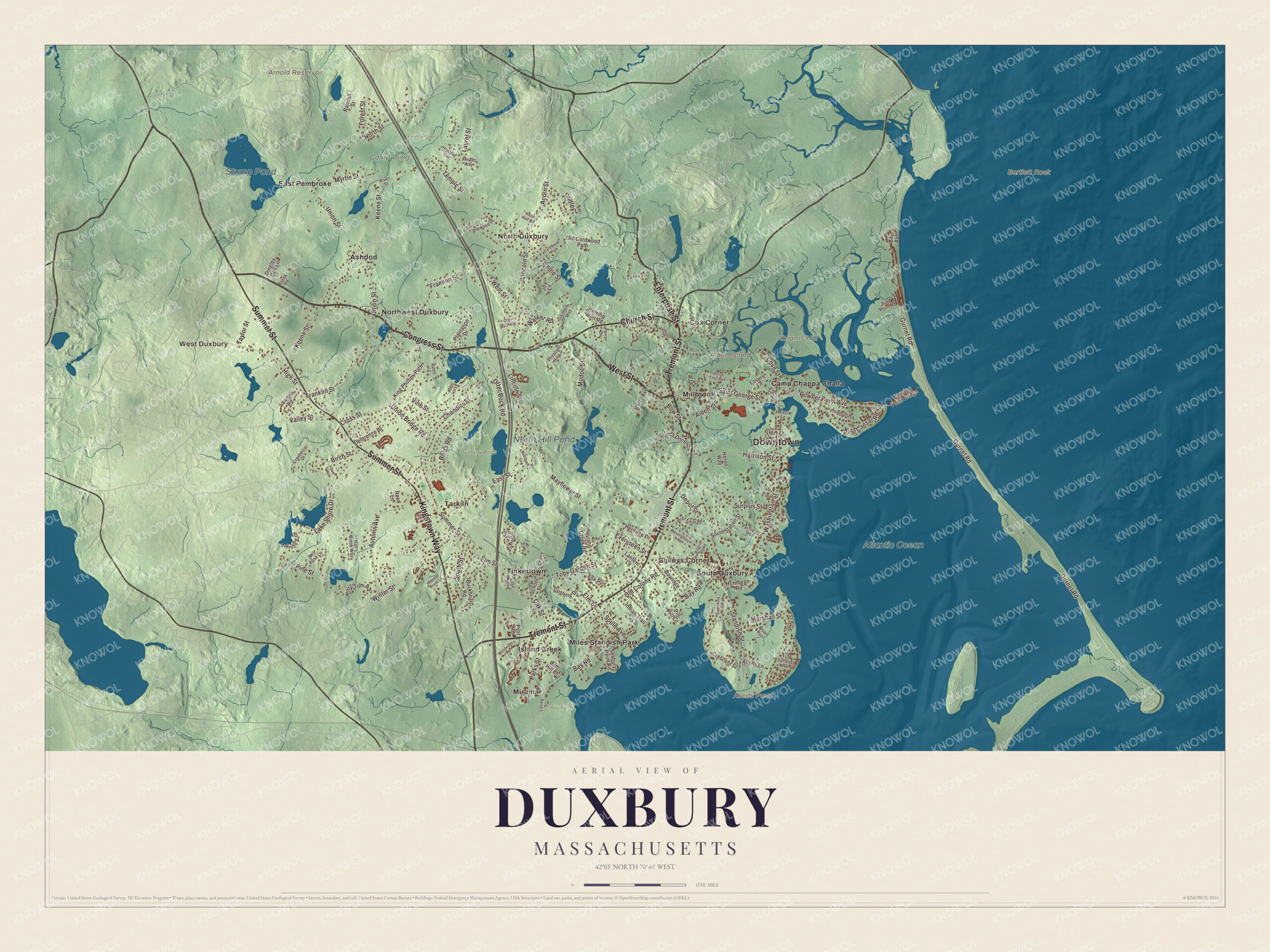
Click to explore a larger preview. The digital watermark does not appear on printed maps.
Names on this map
These names are printed on this map.
Places: Downtown, West Duxbury, Abrams Hill, Alden Island, Bartlett Rock, Allens Pond, Arnold Reservoir, Stump Pond, North Hill Pond, Atlantic Ocean, Bay Farm, Camp Wing, Duxbury Bogs, Feinberg Bogs, Ashdod, Baileys Corner, Camp Chappa Challa, Cox Corner, East Pembroke, Island Creek, Miles Standish Park, Millbrook, Miramar, North Duxbury, Northwest Duxbury, South Duxbury, Tarkiln and Tinkertown.
Streets and roads: Congress Street, West Street, Tremont Street, Summer Street, Kingstown Way, Church Street, Enterprise Street, Washington Street, Saint George Street, Powder Point Avenue, Depot Street, Bay Road.
More street names, A to Z
Acorn Street, Alden Street, Allens Lane, Amado Way, Apple Hill Lane, Autumn Avenue, Bassett Brook Lane, Bay Avenue, Bayridge Lane, Birch Street, Bolas Road, Bow Street, Brook Road, Buckboard Road, Captains Hill Road, Cedar Street, Chandler Street, Cherry Lane, Cordwood Path, Cove Street, Cranberry Drive, Crescent Street, Cross Street, Cushing Drive, Deer Run, Delorenzo Drive, Dingley Dell Lane, Dudley Lane, East Street, Elm Hill Lane, Elm Street, Evergreen Street, Forest Street, Forge Way, Fox Run, Franklin Street, Gifford Way, Gurnet Road, Hall's Brook Way, Harrison Street, Heritage Lane, Heron Way, Herring Weir Road, Highland Trail, High Street, Hitty Tom Road, Hornbeam Road, Hounds Ditch Lane, Indian Trail, Island Creek Road, Joy Lane, Keene Street, King Caesar Road, King Phillips Path, Lake Shore Drive, Lakeshore Drive, Lantern Lane, Laurel Street, Lincoln Street, Loring Street, Lovers Lane, Marshall Street, Mayflower Street, Meetinghouse Road, Merry Avenue, Mill Pond Lane, Modoc Street, Myrtle Street, North Street, Oak Street, Ocean Avenue, Old Barn Road, Old Colony Road, Old Cordwood Path, Onion Hill Road, Orchard Lane, Otter Rock Road, Parks Street, Partridge Road, Perry Drive, Peterson Road, Pettibush Lane, Pheasant Hill Lane, Pilgrim Bywy, Pill Hill Lane, Pine Lake Road, Pine Point Road, Pine Street, Plantation Drive, Post Road, Powder Point Bridge, Prior Farm Road, Quail Run, Randall Street, Reed Lane, River Lane, River Street, Ryans Lane, Samoset Road, Sawmill Road, School Street, Seabury Point Road, Soule Avenue, South Station Street, South Street, Standish Street, Sunset Road, Surplus Street, Taylor Street, Temple Street, Templewood Drive, Toby Garden Street, Union Bridge Road, Union Hall Road, Union Street, Valley Street, Vine Street, Walker Road, Winter Street, Woodridge Road.
Captain’s Hill and the beach
On Captain’s Hill, once part of Standish’s farm, the Myles Standish Monument rises 116 feet, topped by a 14-foot statue of Standish looking east across Massachusetts Bay. Ten thousand people came to lay its cornerstone in 1872, and it was finished in 1898. Duxbury Beach is a six-mile barrier beach reached by the Powder Point Bridge, which George Wright built in 1892; the town’s page says it was in the Guinness World Records as the world’s longest and oldest wooden bridge until a 1985 fire, and it was rebuilt in its original style in 1986. The beach is the only land route to Saquish and Gurnet Point, across the line in Plymouth. Inland, Island Creek Pond in the village of Tinkertown feeds Island Creek, and Mass Audubon keeps a sanctuary at North Hill Marsh on Mayflower Street. The town’s page ranks Duxbury sixth among the state’s cranberry growers.
Around the map
Start with West Duxbury, then follow Congress Street, West Street, Tremont Street, Summer Street, Kingstown Way and Church Street across town, and look outward toward Ashdod, Baileys Corner, Cox Corner, East Pembroke and Island Creek. At the Tree of Knowledge Corner, where Elm, Summer and South streets meet, mail carriers once left mail in boxes nailed to a tree; lightning took the tree, and an engraved stone stands in its place. Allens Pond, Arnold Reservoir, Stump Pond, North Hill Pond, Abrams Hill, Island Creek and Alden Island are all printed on the map.
The Duxbury map makes a fine addition to an office, library or den, and it can help teach children the geography and history of a town the Pilgrims settled. It’s made for people who call Duxbury home, from West Duxbury to Island Creek, and it shows the town as it looks today. Zoom in on the preview above to explore the details, then click here to get your copy of the Duxbury, Massachusetts map.

We made a map for every town and city in Massachusetts. Explore the complete Massachusetts map collection and find your town.
Sources
- Duxbury, Massachusetts, Wikipedia
- John and Priscilla Alden Family Sites, Wikipedia
- King Caesar House, Wikipedia
- Myles Standish Monument State Reservation, Wikipedia
- Duxbury Beach, Wikipedia
- Island Creek Pond, Wikipedia
- City and Town Incorporation and Settlement Dates, Secretary of the Commonwealth of Massachusetts (archived copy)