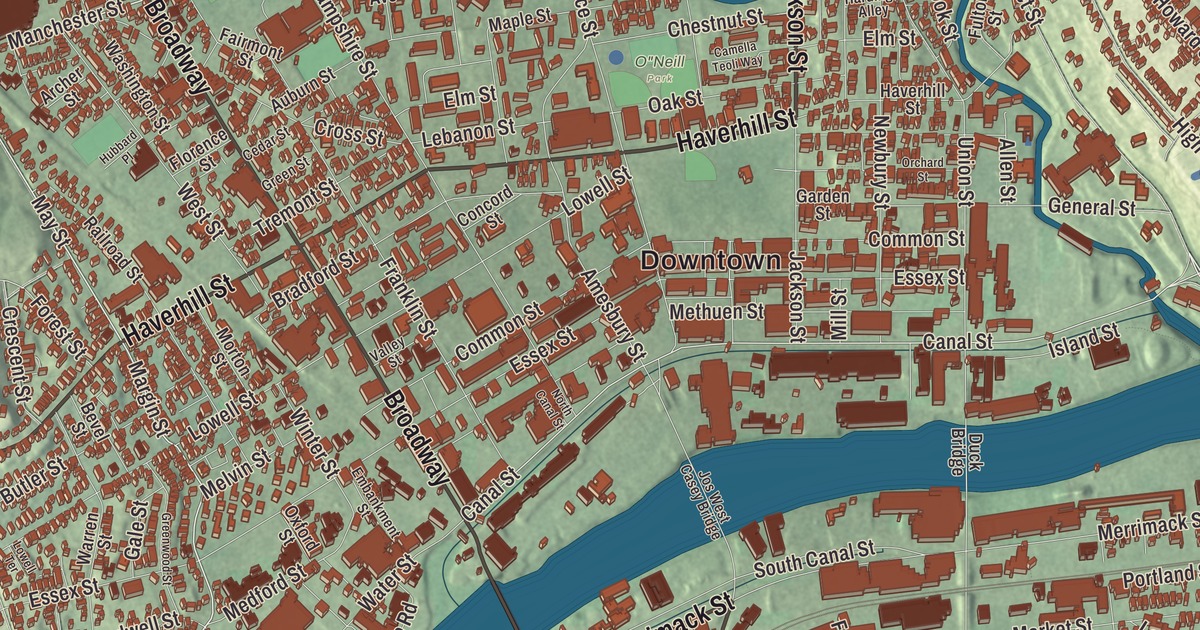
Lawrence spreads across both banks of the Merrimack River, from Tower Hill in the northwest corner to Mount Vernon along the southern edge. This map prints Broadway, South Broadway, Haverhill Street, Jackson Street, Winthrop Avenue and the Salem Turnpike, with Tower Hill, Prospect Hill, Daddy Frye Hill, Stevens Pond and the Spicket River Reservoir. Click here to purchase a print of this map for your wall.
Lawrence is in Essex County.
KNOWOL made this map in 2026 from public survey data and gave it the look of an old atlas. The relief comes from United States Geological Survey elevation data, and the streets and the city line come from the Census Bureau. Lawrence covers 7.4 square miles about 26 miles up the Merrimack from the ocean and 30 miles north-northwest of Boston. Methuen surrounds it on the north side of the river, and North Andover and Andover border it on the south. The Spicket River flows in from Methuen, and the Shawsheen River forms the city’s southeastern edge. Lawrence had 89,143 people at the 2020 census.
A new city on the Merrimack
Native people lived along the Merrimack for thousands of years, and traces of farming have been found at Den Rock Park. The City of Lawrence’s recorded history, in the Secretary of the Commonwealth’s list, dates European settlement to 1655; the city page places the first settlement inside today’s limits that year, a blockhouse in Shawsheen Fields, now South Lawrence. The land was then part of Methuen and Andover. In the 1840s a group of industrialists, Abbott Lawrence among them, bought control of the river’s falls, and in 1845 they incorporated as the Essex Company and began the Great Stone Dam at Bodwell’s Falls. Finished in 1848, the dam is 900 feet long and 35 feet high, and the city page says it was the largest dam in the world when it was built. It still feeds the canals on both banks, and you can see it from Broadway, which is Route 28.
People called the new place “New City,” “Essex” or “Merrimac” until Lawrence was incorporated as a town in 1847. It was incorporated as a city in 1853 and named for Abbott Lawrence. Mills rose along the canals, and workers came from across the world, beginning with the Irish in 1845 and then Germans, French Canadians, English, Italians, Lebanese, Poles, Lithuanians, Jews and many more. The city earned the nickname “Immigrant City.” French Canadians built St. Anne’s Church at Haverhill and Franklin streets in 1872 and later Sacred Heart on South Broadway, and Lebanese families settled on Tower Hill and Prospect Hill. Since the 1960s, families from the Dominican Republic, Puerto Rico and other Latin American countries have made Lawrence home, and the Feast of Three Saints, begun by Sicilian immigrants in 1923, still goes on.
Bread and Roses
In January 1912, when a new state law cut the work week and the mills cut pay to match, workers walked out. The strike, remembered as the Bread and Roses Strike, began at the Everett Mills, grew to more than twenty thousand workers from more than 51 nationalities, and held through two bitterly cold months. The strikers sent hundreds of their children to sympathetic families in New York, New Jersey and Vermont, Congress held hearings, and the mill owners settled, giving raises of up to 20 percent to workers in Lawrence and across New England. The city page calls it one of the more important labor struggles in American history. Lawrence Heritage State Park, in a restored 1840s boarding house, tells the story of the mill workers and hosts the yearly Bread and Roses Festival.
Lawrence has given the country some well-known voices. Robert Frost grew up here, graduated from Lawrence High School in 1892, published his first poem in the school magazine and once worked at the Everett Mill. Leonard Bernstein was born in Lawrence on August 25, 1918, and the singer Robert Goulet was born in 1933 on Haverhill Street, where he also lived.
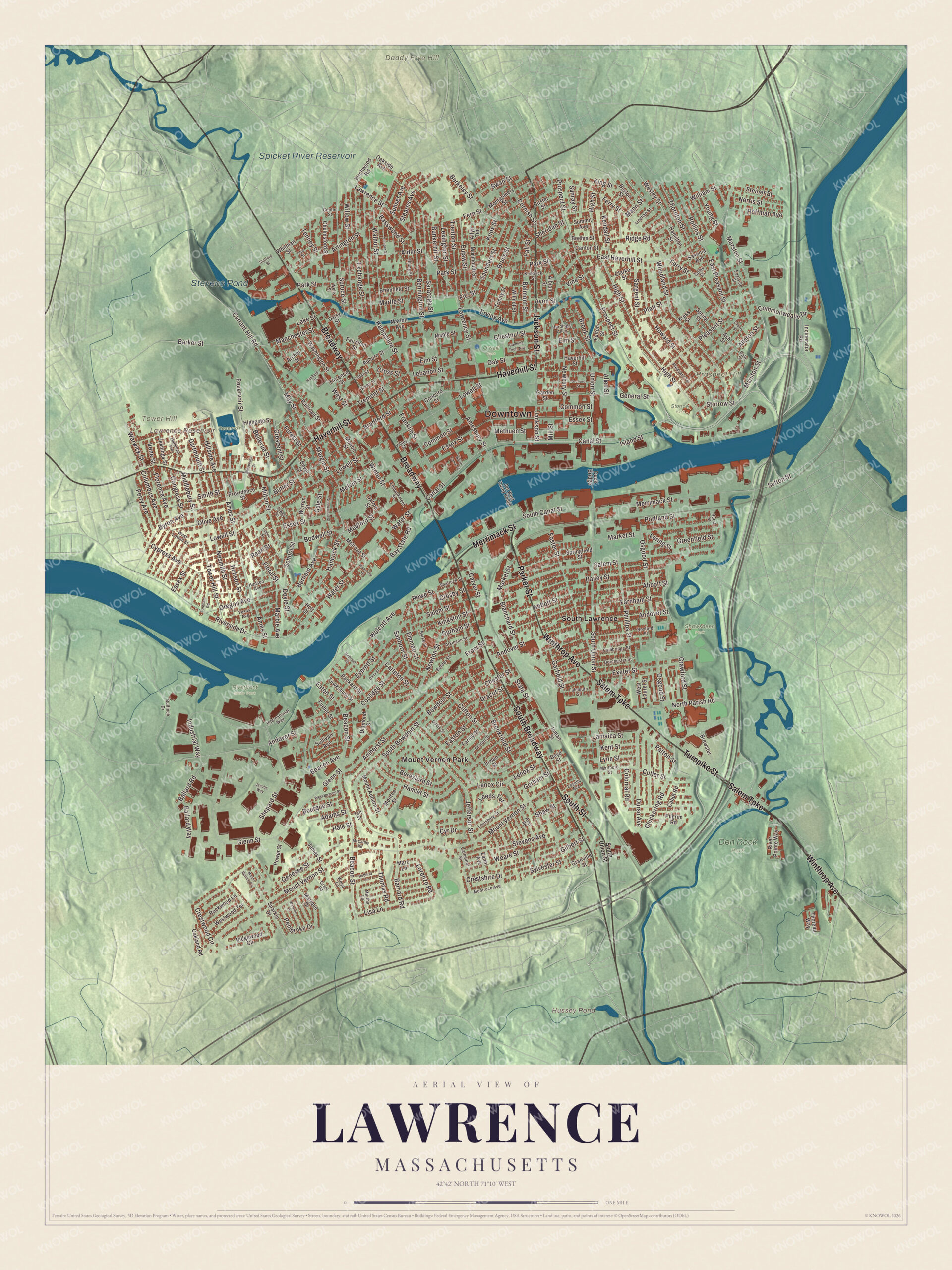
Click to explore a larger preview. The digital watermark does not appear on printed maps.
Names on this map
These names are printed on this map.
Places: Downtown, Daddy Frye Hill, Prospect Hill, Tower Hill, Hussey Pond, Lawrence Reservoir, Spicket River Reservoir, Stevens Pond, Den Rock Park, Reservoir Park, Riverfront State Park, Shawsheen Park, Storrow Park, O"Neill Park, Mount Vernon Park and South Lawrence.
Streets and roads: Jackson Street, Haverhill Street, Salem Turnpike, South Broadway, Winthrop Avenue, Broadway, Turnpike Street, Parker Street, Merrimack Street, South Street, Marston Street, Prospect Street.
More street names, A to Z
Abbott Street, Adams Street, Albion Street, Alder Street, Allen Street, Allston Street, Allyn Terrace, Amesbury Street, Ames Street, Amherst Street, Andover Street, Archer Street, Arlington Street, Ash Street, Atkinson Street, Auburn Street, Avon Street, Ayer Road, Bailey Street, Ballard Road, Ballard Way, Barker Street, Barnard Road, Basswood Street, Bay State Road, Beacon Avenue, Beacon Street, Belknap Street, Bellevue Street, Belmont Street, Bennington Street, Beresford Street, Berkeley Street, Bernard Avenue, Bevel Street, Birchwood Road, Blanchard Street, Bodwell Street, Boehm Street, Border Street, Boston Street, Bourque Street, Bowdoin Street, Boxford Street, Boyd Street, Bradford Street, Brewster, Bromfield Street, Brookfield Street, Brook Street, Bruce Street, Bulfinch Drive, Bunkerhill Street, Burke Street, Butler Street, Byron Avenue, Cabot Road, Cambridge Street, Camella Teoli Way, Canal Street, Canton Street, Carleton Street, Carver Street, Cathedral Street, Cedar Street, Center Street, Chelmsford Street, Cherry Street, Chester Street, Chestnut Street, Chickering Road, Clarke Street, Clifton Street, Colby Street, Colonial Road, Columbus Avenue, Common Street, Commonwealth Drive, Concord Street, Congress Street, Coolidge Street, Cornish Street, Crawford Street, Crescent Street, Crestshire Drive, Crestwood Circle, Crosby Street, Cross Street, Currant Hill Road, Custer Street, Cutler Street, Cypress Avenue, Cyr Drive, Daisy Street, Dale Street, Dana Street, Dartmouth Street, Davis Street, Diamond Street, Dorchester Street, Doyle Street, Dracut Street, Duck Bridge, Durham Street, Durso Avenue, East Haverhill Street, Easton Street, East Pleasant Street, Eastside Street, Eaton Street, Elm Street, Embankment Street, Emmett Street, Erving Avenue, Essex Street, Eutaw Street, Everett Street, Exchange Street, Exeter Street, Fairmont Street, Falmouth Street, Farley Street, Farnham Street, Fern Street, Ferry Street, Fitz Street, Floral Street, Florence Avenue, Florence Street, Fordham Road, Forest Street, Foster Street, Franklin Street, Front Street, Fulton Street, Furber Street, Gale Street, Garden Street, Garfield Street, General Street, Genesee Street, Gilbert Street, Glenn Street, Gorham Street, Grant Road, Granville Street, Greenfield Street, Green Street, Greenwood Street, Groton Street, Hale Street, Hallenan Avenue, Hall Street, Hamilton Street, Hamlet Street, Hampshire Street, Hancock Street, Hardings Alley, Highgate Street, High Street, Hillside Avenue, Hobson Street, Hoffman Avenue, Holt Street, Howard Street, Hubbard Place, Hudson Avenue, Hurst Street, Incinerator Road, Industrial Way, Inman Street, International Way, Irene Street, Island Street, Jacobs Way, Jamaica Street, James Street, Jefferson Street, Jennings Street, Jos West Casey Bridge, Juniper Street, Kendall Street, Kendrick Street, Kent Street, Kingston Street, King Street, Knox Street, Kress Street, Lake Street, Lasalle Avenue, Lawrence Street, Lea Street, Lebanon Street, Leeds Terrace, Lenox Circle, Lenox Street, Lexington Street, Linden Street, Linehan Street, Lisa Lane, Lorenzo Road, Loring Street, Louisberg Street, Lowell Street, Lowell Terrace, Lynn Street, Manchester Street, Mann Street, Maple Street, Marble Avenue, Marc Lane, Margin Street, Marion Avenue, Marique Drive, Market Street, Marlboro Street, Martha Lane, May Street, McCarthy Road, Medford Street, Melrose Street, Melvin Street, Methuen Street, Middlebury Street, Mill Street, Milton Street, Monmouth Street, Monroe Street, Montgomery Street, Montrose Avenue, Morton Street, Mount Auburn Street, Mount Vernon Circle, Mount Vernon Street, Myrtle Street, Nesmith Street, Newbury Street, Newton Street, Norris Street, North Canal Street, North Parish Road, Oakland Road, Oakside Avenue, Oak Street, Olive Avenue, Orchard Street, Oregon Avenue, Osgood Street, Oxford Street, Packard Street, Park Street, Patton Street, Pearl Street, Pembroke Drive, Perry Avenue, Phillips Street, Pilgrim Road, Platt Street, Pleasant Street, Pleasant Terrace, Portland Street, Power Street, Providence Street, Railroad Street, Reservoir Drive, Reservoir Street, Rhine Street, Ridge Road, Ridgewood Circle, River Pointe Way, Riverside Drive, Riverview Place, Roberta Lane, Rockwood Lane, Rollins Street, Rowe Street, Salem Street, Sanborn Street, Saratoga Street, Sargent Street, Saunders Street, Saxonia Avenue, School Street, Shattuck Street, Shaw Street, Shepard Street, Sheridan Street, Smith Street, South Bowdoin Street, South Canal Street, South Union Street, Sparkle Drive, Springfield Street, Spring Street, Spruce Street, Stafford Street, State Street, Stearns Avenue, Steiner Street, Stevens Avenue, Storrow Street, Sullivan Avenue, Summit Avenue, Sunray Street, Sunset Avenue, Sutton Street, Swan Street, Sylvester Street, Taft Street, Tenney Street, Tewksbury Street, Texas Avenue, Thomas Road, Thoreau Way, Thornton Street, Tower Hill Street, Tremont Street, Trenton Street, Trinity Street, Union Street, Valley Street, Vine Street, Walnut Street, Warren Street, Warwick Street, Washington Street, Water Street, Weare Street, Wells Street, Wesley Street, West Beacon Street, West Laurel Street, West Lowell Street, West Street, Westwood Terrace, Whitman Street, William Street, Willow Street, Wilmot Street, Winston Drive, Winter Street, Wolcott Avenue, Woodland Street, Wood Lane, Young Street, Zanni Avenue.
Around the map
Start with Mount Vernon Park, then follow Jackson Street, Haverhill Street, the Salem Turnpike, South Broadway, Winthrop Avenue and Broadway across the city. Look outward toward South Lawrence. Hussey Pond, the Lawrence Reservoir, the Spicket River Reservoir, Stevens Pond, Daddy Frye Hill, Prospect Hill and Tower Hill are all printed on the map, and every one of those names is right there on the artwork. Tower Hill, in the northwest corner, is the highest point in Lawrence at about 240 feet, and its brick High Service Water Tower, 157 feet tall and built in 1896, is on the National Register with the reservoir beside it. Prospect Hill rises in the northeast, and Mount Vernon runs along the southern edge.
The Lawrence map makes a fine addition to an office, library or den, and it can help teach children the geography and history of the Immigrant City. It’s made for people who call Lawrence home, from Tower Hill to South Lawrence, and it shows the city as it looks today. Zoom in on the preview above to explore the details, then click here to get your copy of the Lawrence, Massachusetts map.

We made a map for every town and city in Massachusetts. Explore the complete Massachusetts map collection and find your town.
Sources
- Lawrence, Massachusetts, Wikipedia
- Great Stone Dam, Wikipedia
- Abbott Lawrence, Wikipedia
- 1912 Lawrence textile strike, Wikipedia
- The Everett Mills, Wikipedia
- Lawrence Heritage State Park, Wikipedia
- Robert Frost, Wikipedia
- Leonard Bernstein, Wikipedia
- Robert Goulet, Wikipedia
- High Service Water Tower and Reservoir, Wikipedia
- City and Town Incorporation and Settlement Dates, Secretary of the Commonwealth of Massachusetts (archived copy)