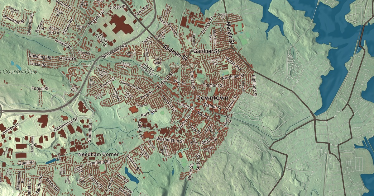
Peabody is still known locally as the Leather City or the Tanner City, and its high school’s mascot is named the Tanners. This map of the city prints Andover Street, Margin Street, Newbury Street, Gardner Street, Main Street and the Newburyport Turnpike, with Cedar Pond, Suntaug Lake, Bow Ridge and Buxton Hill. Click here to purchase a print of this map for your wall.
Peabody is in Essex County.
KNOWOL made this map in 2026 from public survey data and gave it the look of an old atlas. The ground under the streets comes from United States Geological Survey elevation data, and the streets and the city line come from the Census Bureau. Peabody is wedge-shaped, with its center at the wider northeastern end, 2 miles from the center of Salem and 15 miles northeast of Boston. It covers 16.8 square miles and had 54,481 people at the 2020 census.
From Salem’s farms to South Danvers
The Naumkeag lived here long before the English. In 1626 a small group of English colonists from Cape Ann, led by Roger Conant, settled the area as part of Salem. The City of Peabody’s recorded history dates European settlement to 1626. Over the years the land was called the Northfields, Salem Farms and Brooksby. In 1752 it was set off from Salem as part of the district of Danvers and known as the South Parish, after its church in what’s now Peabody Square. The Nathaniel Felton house on Felton Street dates from around 1700; his son’s house, moved there by a grandson, stands beside it, and the Peabody Historical Society runs both as museums. In 1855 the South Parish broke away as the town of South Danvers.
George Peabody was born here in 1795, in a house on Washington Street. He grew up poor, left school after only a few years, and went on to become a banker in London, where his firm later grew into J.P. Morgan & Co. He’s often called the father of modern philanthropy. In 1852 he gave money for a free library with a lyceum in his hometown, then part of Danvers, and the Peabody Institute Library, built in 1853 on the north side of Main Street and dedicated in 1854, is claimed to be the oldest public library in the United States to operate continuously from the same location. On April 30, 1868, South Danvers changed its name to Peabody in his honor. Peabody was incorporated as a town in 1868. It was incorporated as a city in 1916. His birthplace at 205 Washington Street is now the George Peabody House Museum, which shares its site with the Peabody Leather Museum.
The Leather City
Mills grew up along the city’s rivers and streams, and in the 1700s the Central Street corridor was a center of pottery making, especially redware. Above all, Peabody became a major center of New England’s leather industry, which drew immigrants from all over the world; by 1915 a third of the people had been born outside the United States. Irish and Russian families came, and so did workers from the region of Harput in the Ottoman Empire, mostly Turkish and Kurdish speakers, who filled the boarding houses and coffee houses of Walnut Street. The tanneries stayed at the center of the city’s economy into the second half of the 20th century before they closed or moved away. Early in the 1900s Peabody also built automobiles, as the home of the Brass Era company Corwin Manufacturing.
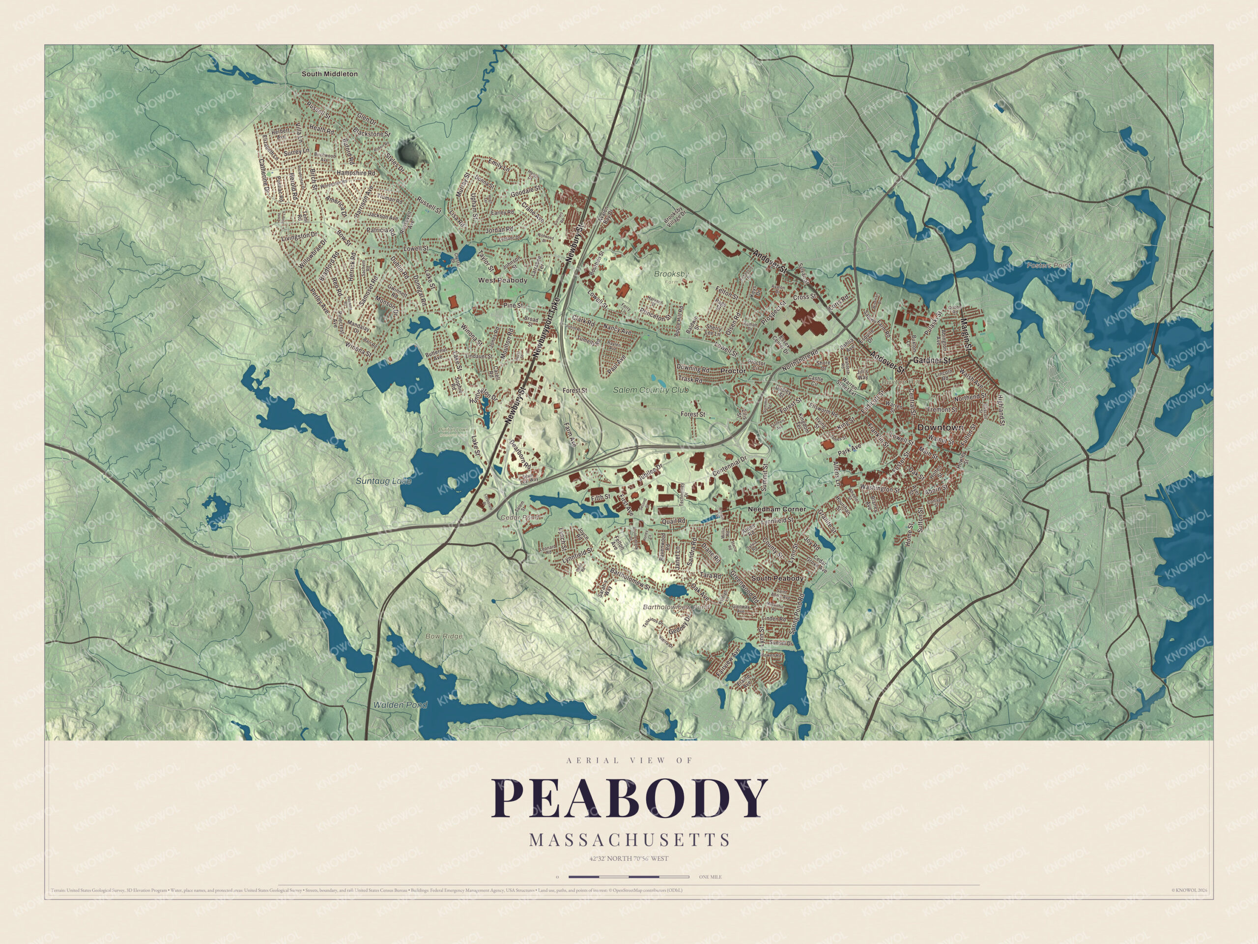
Click to explore a larger preview. The digital watermark does not appear on printed maps.
Names on this map
These names are printed on this map.
Places: Downtown, West Peabody, Bow Ridge, Buxton Hill, Fosters Point, Bartholowmew Pond, Cedar Pond, Walden Pond, Suntaug Lake, Brooksby Farm, Puritan Lawn Memorial Park, Needham Corner, Proctor, South Middleton, South Peabody and Salem Country Club.
Streets and roads: Andover Street, Margin Street, Newbury Street, Newburyport Turnpike, Gardner Street, Main Street, Endicott Street, Foster Street, King Street, Russell Street, Park Avenue, Dearborn Road.
More street names, A to Z
Abington Avenue, Aborn Street, Alden Road, Allens Lane, America Drive, Apple Hill Road, Avalon Bay Drive, Avalon Drive, Ayer Street, Baldwin Street, Barr Road, Bartholomew Street, Birch Street, Birchwood Avenue, Blackstone Street, Blaney Avenue, Boulderbrook Drive, Bourbon Street, Bowen Road, Bow Street, Bradford Road, Broad Street, Brooksby Village Drive, Buford Road, Butternut Avenue, Buxton Lane, Carell Road, Castle Circle, Catherine Drive, Cedar Grove Avenue, Centennial Drive, Central Street, Clark Road, Connors Road, Corporate Place, Corwin Street, Cottage Street, County Street, Crane Avenue, Cross Street, Crystal Drive, Dahlia Avenue, Diane Road, Dobbs Road, Donegal Road, Donna Street, Downing Road, Driscoll Street, Dublin Road, Dudley Street, Earley Road, Elaine Avenue, Elizabeth Lane, Ellis Street, Ellsworth Road, Emily Lane, Esquire Drive, Essex Center Drive, Fairview Avenue, Farm Avenue, Farnham Avenue, Felton Avenue, Felton Street, Ferry Lane, Fifth Street, First Avenue, Forest Street, Franklin Street, Fulton Street, Gedney Drive, Glen Drive, Glenway Avenue, Goodale Street, Granite Street, Greenwood Road, Gwinnett Road, Hampshire Road, Harrison Avenue, Harvard Street, Hazel Street, Heath Road, Helen Drive, Herbert Avenue, Herold Road, Herrick Road, Highland Street, Holten Street, Home Street, Honey Lane, Hourihan Street, Howley Street, Hugh Terrace, Huntington Drive, Irving Street, Jackson Avenue, James Street, Janet Lane, Jill's Way, Johnson Street, Jones Road, Jordan Road, Joyce Road, Joy Road, Jubilee Drive, Judith Road, Keys Drive, Kingdom Terrace, Kyleigh Lane, Lake Street, Larrabee Terrace, Leblanc Drive, Leonard Road, Lincoln Road, Lindauer Street, Linden Road, Lisa Road, Livingston Drive, Lone Pine Lane, Loris Road, Lowell Street, Lynch Street, Lynnfield Street, Lynn Street, Macarthur Road, Mandalay Drive, Monson Drive, Moulton Road, Murray Street, Nancy Avenue, Northend Street, Northshore Road, Oak Avenue, Oak Street, Olsen Road, Page Street, Patricia Road, Paul Avenue, Pearl Road, Perley Avenue, Pinecrest Avenue, Pine Street, Pocahontas Drive, Pontiac Road, Princeton Street, Proctor Circle, Prospect Street, Pulaski Street, Quail Road, Ravenwood Road, Raylen Avenue, Reo Road, Richartson Road, Robert Road, Roosevelt Avenue, Sabino Farm Road, Sachem Road, Saint Ann's Avenue, Salem Street, Samoset Road, Sandra Road, Sarah's Way, Second Street, Sherry Lee Lane, Shore Drive, Silver Leaf Way, Sophie Road, Spring Pond Road, Squanto Road, Stacia Road, Styles Drive, Summit Street, Summit Terrace, Sunset Drive, Surrey Lane, Sutton Street, Sylvan Street, Sylvia Road, Tara Road, Taylor Street, Technology Drive, Temi Road, Tomah Drive, Trask Road, Tremont Street, Truman Road, Tsitsinos Drive, Tumelty Road, Upham Street, Vieira Drive, Villa Lane, Wahtera Road, Walnut Street, Walsh Avenue, Warren Street, Warren Street Extension, Washington Street, Wheeler Street, Wildwood Drive, Willis Road, Willowbrae Drive, Winona Street, Wiseman Drive, Worcester Road.
See it on a wall
The Peabody map as a framed print. Swipe for more.


Around the map
Start with West Peabody, then follow Andover Street, Margin Street, Newbury Street, the Newburyport Turnpike, Gardner Street and Main Street across the city. Then look outward toward Needham Corner, Proctor, South Middleton and South Peabody. Cedar Pond, Walden Pond, Suntaug Lake, Bow Ridge and Buxton Hill are printed on the map as well. You’ll find Bartholomew Pond there too. West Peabody, where the high school is, was mostly farmland until the 1950s; it’s separated from the city center by the highways and the Proctor neighborhood, and South Peabody lies south of the center, home to the city-owned Tillie’s Farm. Only part of Suntaug Lake lies inside the city. The Washington Street Historic District runs south from Main Street along a road laid out in 1750 as part of the post road between Salem and Boston, where the city’s business and civic leaders built their houses; the 1810 Gen. Gideon Foster House there is now a museum. Brooksby Farm, 275 acres owned by the city, is the largest protected piece of Peabody.
The Peabody map makes a fine addition to an office, library or den, and it can help teach children the geography and history of the Leather City. It’s made for people who call Peabody home, from West Peabody to Peabody Square, and it shows the city as it looks today. Zoom in on the preview above to explore the details, then click here to get your copy of the Peabody, Massachusetts map.

Sources
- Peabody, Massachusetts, Wikipedia
- Nathaniel Felton Houses, Wikipedia
- George Peabody, Wikipedia
- George Peabody House Museum, Wikipedia
- Peabody Institute Library (Peabody, Massachusetts), Wikipedia
- Washington Street Historic District (Peabody, Massachusetts), Wikipedia
- City and Town Incorporation and Settlement Dates, Secretary of the Commonwealth of Massachusetts (archived copy)