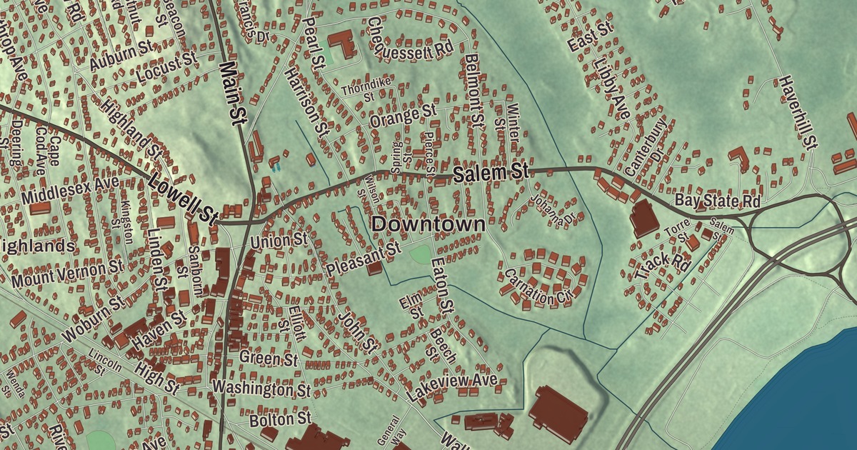
Main Street in Reading began as the Andover Turnpike, built by a private company in 1806 and 1807 to give the town a better road to Boston. This map of the town prints Main Street, Lowell Street, Salem Street, Summer Avenue, Winslow Road and Lakeview Avenue, with Bear Hill, Cowdry Hill, Dobbins Hill, Bare Meadow and Lake Quannapowitt. Click here to purchase a print of this map for your wall.
Reading is in Middlesex County.
KNOWOL made this map in 2026 from public survey data and gave it the look of an old atlas. The rise and fall of the land comes from United States Geological Survey elevation data, and the streets and the town line come from the Census Bureau. Reading lies 16 miles north of central Boston and covers 9.9 square miles, with little standing water but many vernal pools in its conservation land. Woburn, Stoneham, Wakefield, Lynnfield, North Reading and Wilmington border it, and it had 25,518 people at the 2020 census.
Lynn Village
The Town of Reading’s recorded history, in the Secretary of the Commonwealth’s list, dates European settlement to 1639. That year some citizens of Lynn asked the colony for “a place for an inland plantation,” and their first settlement, called Lynn Village, grew up on the south shore of the Great Pond, the lake now named Quannapowitt. Reading was incorporated as a town in 1644, on June 10, and took its name from Reading in England; there’s evidence that one founder, Thomas Parker, was “conspicuous in naming the town.” The town once reached much farther. Its first parish broke away in 1812 as South Reading and renamed itself Wakefield in 1868, and the land north of the Ipswich River, added in 1651, became North Reading in 1853. Today’s Reading was first known as Wood End, or the Third Parish.
In 1693 town meeting voted money for public schooling, and in 1769 a meeting house went up on what’s now the Common, where a stone marker shows the spot. When the alarm came on April 19, 1775, John Brooks, a young doctor practicing in Reading and a major in its militia, marched his men toward Concord, and they were among the first to reach it as the British turned back to Boston. Brooks later served at Valley Forge and became Governor of Massachusetts. Sixty members started the Federal Library, a subscription library, in 1791, and the public library followed in 1868.
Chairs, clocks and caskets
The Boston and Maine Railroad reached Reading in 1845. In the first half of the 1800s the town turned to manufacturing: Sylvester Harnden’s furniture factory, Daniel Pratt’s clock factory and Samuel Pierce’s organ pipe factory were major businesses, and by the middle of the century thirteen shops made chairs and cabinets. Shoemaking grew from home work into large factories, neckties were made here for about ninety years, and for a long time Reading was an important casket maker. In the 20th century it became a small residential town with trains and streetcars to Boston. The marathoner Clarence DeMar, who won the Boston Marathon seven times, died in Reading in 1958. Bill Russell, a Boston Celtic from 1956 to 1969, lived in Reading in the 1960s.
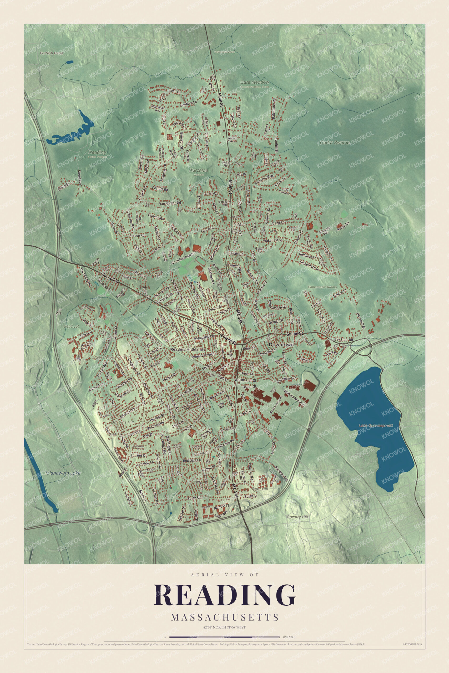
Click to explore a larger preview. The digital watermark does not appear on printed maps.
Names on this map
These names are printed on this map.
Places: Downtown, Reading Highlands, Bear Hill, Cowdry Hill, Dobbins Hill, Long Woods Hills, Furbish Pond, Lake Quannapowitt, Mishawum Lake, Bare Meadow Conservation Area, Boyd Lot, Cedar Swamp, Fairbanks Marsh, Kurchian Woods, Reading Town Forest, Timberneck Swamp and Terrace Park.
Streets and roads: Lowell Street, Main Street, Salem Street, Summer Avenue, Winslow Road, Lakeview Avenue, Willow Street, Glenmere Circle, Birch Meadow Drive, Walkers Brook Drive, Highland Street, Haverhill Street.
More street names, A to Z
Abigail Way, Alden Circle, Arcadia Avenue, Archstone Circle, Arnold Avenue, Ash Hill Road, Ashley Place, Ash Street, Auburn Street, Audubon Road, Augustus Court, Autumn Lane, Avalon Road, Avon Street, Bainbridge Road, Baker Road, Bancroft Avenue, Barbara Lane, Batchelder Road, Bay State Road, Beacon Street, Bear Hill Road, Beaver Road, Beech Street, Belmont Street, Benton Circle, Berkeley Street, Beverly Road, Blueberry Lane, Bolton Street, Bond Street, Border Road, Boswell Road, Bradford Road, Briarwood Avenue, Brook Street, California Road, Canterbury Drive, Cape Cod Avenue, Carnation Circle, Catherine Avenue, Causeway Road, Chapel Hill Drive, Charles Street, Chequessett Road, Chestnut Road, Clover Circle, Colburn Avenue, Colburn Road, Collins Avenue, Colonial Drive, Countryside Lane, County Road, Covey Hill Road, Criterion Street, Cross Street, Curtis Street, Dana Road, Davis Lane, Dean Road, Deborah Drive, Deering Street, Dragon Court, Duck Road, Dunbar Road, East Street, Eastway, Eaton Street, Edgemont Avenue, Elliott Street, Ellis Avenue, Elm Street, Emerald Drive, Emerson Street, Enos Circle, Estate Lane, Fairchild Drive, Fairmount Road, Fairview Avenue, Field Pond Drive, Forest Glen Road, Forest Street, Fox Run Lane, Francis Drive, Franklin Street, Gavin Circle, Gazebo Circle, General Way, Gleason Road, Glen Road, Grand Street, Grandview Road, Granger Avenue, Grant Street, Green Street, Grey Coach Lane, Grove Street, Hampshire Road, Hancock Street, Harold Avenue, Harrison Street, Hartshorn Street, Harvard Street, Haven Street, Haystack Road, Heather Drive, Hemlock Road, High Street, Hillcrest Road, Hodson Lane, Holly Road, Hopkins Street, Howard Street, Indian Tree Lane, Intervale Terrace, Inwood Drive, Irving Street, Ivy Lane, Jacob Way, James Road, Johanna Drive, John Carver Road, Johnson Woods Drive, John Street, Kieran Road, Kingston Street, King Street, Knollwood Road, Kurchian Lane, Lafayette Road, Larch Lane, Latham Lane, Laurel Lane, Lawrence Road, Lee Street, Lewis Street, Libby Avenue, Lilah Lane, Lincoln Street, Linden Street, Lindsay Lane, Linnea Lane, Lisa Lane, Locust Street, Longfellow Road, Longview Road, Longwood Road, Lothrop Road, Louanis Drive, Lucy Drive, Macmillan Way, Mark Avenue, Marla Lane, Martin Road, Melbourne Avenue, Middlesex Avenue, Milepost Road, Mill Street, Mineral Street, Minot Street, Mount Vernon Street, Nelson Avenue, Newcrossing Road, Nugent Lane, Oakland Road, Oak Ridge Road, Oak Street, Old Farm Road, Old Mill Lane, Orange Street, Orchard Park Drive, Park Avenue, Parsons Lane, Pasture Road, Pearl Street, Percy Avenue, Perkins Avenue, Pierce Street, Pilgrim Road, Pine Ridge Road, Pinevale Avenue, Pitman Drive, Pleasant Street, Plymouth Road, Pratt Street, Prescott Street, Prospect Street, Puritan Road, Putnam Road, Rachel Road, Range Road, Red Gate Lane, Rice Road, Richards Road, Riverside Drive, Rocky Road, Roma Lane, Rustic Lane, Sanborn Lane, Sanborn Street, Sandra Lane, Scotland Road, Shackford Road, Shelby Road, Sherwood Road, Short Street, Small Lane, South Street, Spring Street, Spruce Road, Strout Avenue, Sturges Road, Summit Drive, Sunnyside Avenue, Sunset Rock Lane, Swan Road, Symonds Way, Tamarack Road, Tarpin Terrace, Taylor Drive, Temple Street, Tennyson Road, Thomas Drive, Thorndike Street, Timberneck Drive, Torre Street, Track Road, Union Street, Vale Road, Van Norden Road, Vine Street, Virginia Road, Wakefield Street, Walnut Street, Warren Avenue, Washington Street, Waverly Road, Wenda Street, Wescroft Road, West Hill Circle, West Street, Whitehall Lane, Whittier Road, Willard Road, Wilson Street, Winter Street, Winthrop Avenue, Woburn Street, Zachary Lane.
Around the map
Start with Reading Highlands. Follow Lowell Street, Main Street, Salem Street, Summer Avenue, Winslow Road and Lakeview Avenue across town. The Parker Tavern, on Washington Street just west of Main Street, was built by 1694 and is the oldest building still standing in Reading. Ephraim Parker kept a tavern there from 1770 to 1785, and the Reading Antiquarian Society has run it as a museum since 1923. The Capt. Nathaniel Parker Red House on Ash Street, built before 1755, stood out in its day because it was painted red, and as a tavern on the coach road it was a meeting place for revolutionaries, among them the Marquis de Lafayette and Alexander Hamilton. Once the Andover Turnpike, now Main Street, bypassed it, its business fell off.
Furbish Pond, Lake Quannapowitt, Mishawum Lake, Bare Meadow, Bear Hill, Cowdry Hill and Dobbins Hill are all printed on the map. Lake Quannapowitt itself lies over the line in Wakefield, where the town common meets its southeastern shore; it’s named for Quonopohit, a Naumkeag man who signed a deed to that town in 1686. In the 20th century one of the town’s two Nike missile sites went up on Bear Hill, and condos on Bear Hill Street now sit over decommissioned Army National Guard missile silos. On Haverhill Street, the concrete roof of St. Athanasius Parish, poured in a single day, is one of the largest hyperbolic paraboloids in the Western Hemisphere.
The Reading map makes a fine addition to an office, library or den, and it can help teach children the geography and history of the town that grew from Lynn Village. It’s made for people who call Reading home, from Reading Highlands to Bear Hill, and it shows the town as it looks today. Zoom in on the preview above to explore the details, then click here to get your copy of the Reading, Massachusetts map.

We made a map for every town and city in Massachusetts. Explore the complete Massachusetts map collection and find your town.
Sources
- Reading, Massachusetts, Wikipedia
- John Brooks (Massachusetts politician), Wikipedia
- Clarence DeMar, Wikipedia
- Parker Tavern, Wikipedia
- Capt. Nathaniel Parker Red House, Wikipedia
- Lake Quannapowitt, Wikipedia
- City and Town Incorporation and Settlement Dates, Secretary of the Commonwealth of Massachusetts (archived copy)