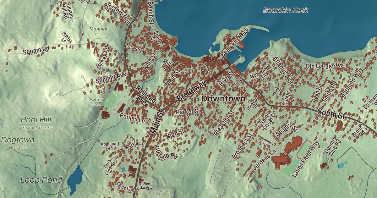
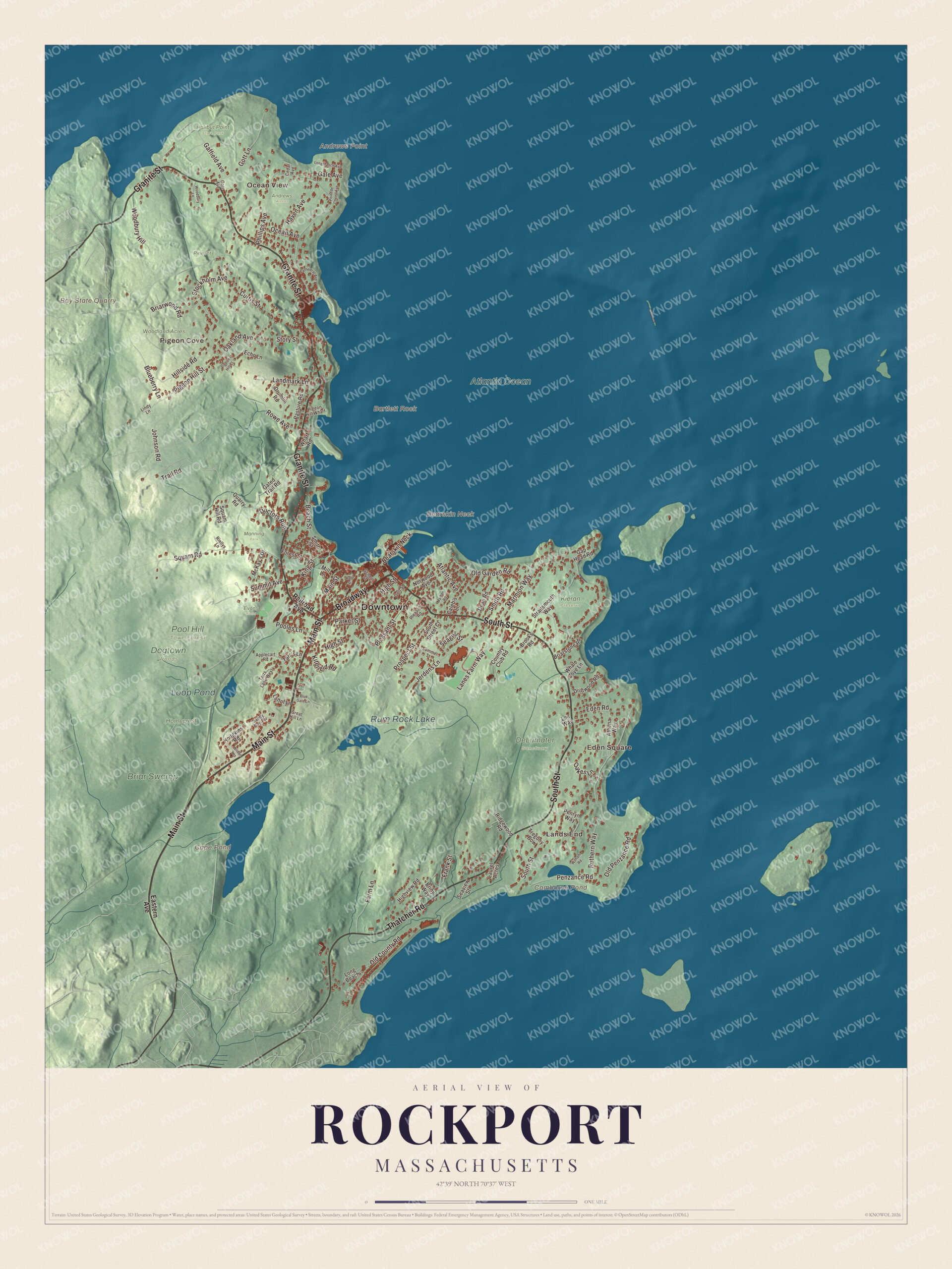
On September 8, 1814, a British barge came around Bearskin Neck at daybreak, the bell of the Congregational Church rang out a warning, and a cannonball meant to silence it lodged in the steeple instead. This map of Rockport prints Main Street, Broadway, Granite Street, South Street, Thatcher Road and Trail Road, with Bearskin Neck, Pigeon Cove, Cape Pond and the Bay State Quarry. Click here to purchase a print of this map for your wall.
Rockport is in Essex County.
KNOWOL made this map in 2026 from public survey data and gave it the look of an old atlas. United States Geological Survey elevation data shapes the rocky land, and the Census Bureau supplied the streets and the town line. Rockport sits at the far eastern tip of Cape Ann, about 40 miles northeast of Boston, with water on three sides and Gloucester as its only neighbor. It covers 17.5 square miles, and 10.5 of them are water, including three islands that belong to the town: Straitsmouth, Thacher and Milk. It had 6,992 people in 2020.
Sandy Bay
Before English settlers came, Cape Ann was home to Agawam villages, and Samuel de Champlain named it Cap aux Isles in 1605. The Town of Rockport’s recorded history, in the Secretary of the Commonwealth’s list, dates European settlement to 1623, the year a permanent settlement was founded in nearby Gloucester. Richard Tarr, a granite cutter, was living here in 1680 as the first settler of the Sandy Bay Colony. Its timber went into ships, its fishing grounds were among the richest in New England, and in 1743 a dock was built on Sandy Bay for both. The first granite quarries opened at the start of the 1800s, and by the 1830s Rockport granite was going to cities all along the East Coast. Rockport was incorporated as a town in 1840, when residents set themselves apart from Gloucester to keep an identity of their own.
Finnish and Swedish immigrants who knew how to work stone made up much of the quarry workforce, and Pigeon Cove especially was home to immigrant families. From March to June 1899 the quarrymen struck, and they won a nine-hour day and overtime pay. The quarries closed during the Great Depression. In 1856 about 200 women led by Hannah Jumper went through town destroying liquor in what became known as Rockport’s revolt against rum, and apart from a stretch in the 1930s the town stayed dry until 2005. The art colony had begun years earlier, in part because the town was a popular vacation spot with rocky, boulder-strewn beaches, and in 1921 artists founded the Rockport Art Association, which the town page counts among the oldest and most active art groups in the country; since 1929 it has been in an old tavern building on Main Street.
Click to explore a larger preview. The digital watermark does not appear on printed maps.
Names on this map
These names are printed on this map.
Places: Downtown, Ocean View, Pigeon Cove, Lands End, Eden Square, Andrews Point, Bartlett Rock, Bay State Quarry, Bearskin Neck, Camborne Pond, Cape Pond, Rum Rock Lake, Loop Pond, Andrews Woods, Atlantic Ocean, Briar Swamp, DeLamater Sanctuary, Dogtown Woods, Halibut Point State Park, Homecrest, Manning Park, Pine Pit, Pool Hill Town Forest, Woodland Acres, Evans Field and Kieran Preserve.
Streets and roads: Main Street, Broadway, Granite Street, South Street, Thatcher Road, Trail Road, Parker Street, Old County Road, Marmion Way, Phillips Avenue, Penzance Road, Rowe Avenue.
More street names, A to Z
Applecart Road, Athena Way, Atlantic Avenue, Beach Street, Blueberry Lane, Blue Gate Lane, Briarstone Road, Briarwood Road, Briny Way, Brooks Road, Caleb's Lane, Cathedral Avenue, Cedar Avenue, Country Club Road, Curtis Street, Dean Road, Doctors Run, Driftwood Road, Drumlin Road, Eastern Avenue, Echo Lane, Eden Road, Farm Lane, Forest Street, Frank Street, Gaffield Avenue, Gale Avenue, Gap Head Road, Gated Trail Road, Gott Avenue, Gott Lane, Gott Street, Great Hill Lane, Hale Street, Haven Avenue, High Street, Highview Road, Hillside Road, Hodgkins Road, Jerdens Lane, Johnson Road, King Street, Kitefield Road, Landmark Lane, Lanes Farm Way, Lattof Lane, Laurel Acres, Lee Way, Lindy Lane, Long Beach, Longbranch Avenue, Marbee Road, McKay's Drive, Mill Lane, Norwood Avenue, Oakes Lane, Oakland Avenue, Ocean Avenue, Old Garden Road, Old Penzance Road, Pasture Road, Penryn Way, Pigeon Hill Court, Pigeon Hill Street, Pigeon Hill Wharf, Pleasant Road, Pleasant Street, Point de Chene Avenue, Pooles Lane, Prospect Street, Quarry Road, Railroad Avenue, Ridgewood Road, Riellys Lane, Ruthern Way, Sandy Bay Terrace, School Street, Seagull Street, Seaview Street, Smith Road, Smith Street, South Street Court, Squam Hill Road, Squam Road, Stockholm Avenue, Story Street, Straitsmouth Way, Summer Street, Summit Avenue, Tarr's Lane, Tarrs Lane West, Tregony Bow, Whale Cove Lane, Wharf Road, Wildon Heights, Witham Road, Woodbury Hill, Woodbury Lane.
See it on a wall
The Rockport map as a framed print. Swipe for more.


Around the map
Start with Ocean View. Follow Main Street, Broadway, Granite Street, South Street, Thatcher Road and Trail Road across town. Then look outward toward Pigeon Cove, Lands End and Eden Square. Camborne Pond, Cape Pond, Rum Rock Lake, Loop Pond, the Bay State Quarry and Bearskin Neck are all printed on the map. Bearskin Neck is a short peninsula of old fishing and lobster shacks that now hold shops, restaurants and galleries, and the Old Stone Fort of the Sea Fencibles still stands at its point. Local legend says it got its name when Ebenezer Babson fought off a bear there and laid its skin out on the rocks. On Bradley Wharf, the red fishing shack called Motif Number 1 is, in the Bearskin Neck page’s words, “the most often-painted building in America.” The Blizzard of 1978 destroyed the original, and an exact copy went up the same year.
The old Babson Farm granite quarry is now Halibut Point State Park and Reservation, where the quarrying ended in 1929 and a World War II fire control tower holds a small museum about Cape Ann granite. On Pigeon Hill Street, the Paper House, built from 1922 to 1924, has walls and furniture made from about 100,000 newspapers. Off the coast, the twin lighthouses of Thacher Island, first lit in 1771 and rebuilt in 1861, stand 124 feet tall and 900 feet apart.
The Rockport map makes a fine addition to an office, library or den, and it can help teach children the geography and history of a granite and fishing town on Cape Ann. It’s made for people who call Rockport home, from Pigeon Cove to Lands End, and it shows the town as it looks today. Zoom in on the preview above to explore the details, then click here to get your copy of the Rockport, Massachusetts map.

Sources
- Rockport, Massachusetts, Wikipedia
- Bearskin Neck, Wikipedia
- Hannah Jumper, Wikipedia
- Rockport Art Association, Wikipedia
- Halibut Point State Park, Wikipedia
- Paper House, Wikipedia
- Thacher Island, Wikipedia
- City and Town Incorporation and Settlement Dates, Secretary of the Commonwealth of Massachusetts (archived copy)