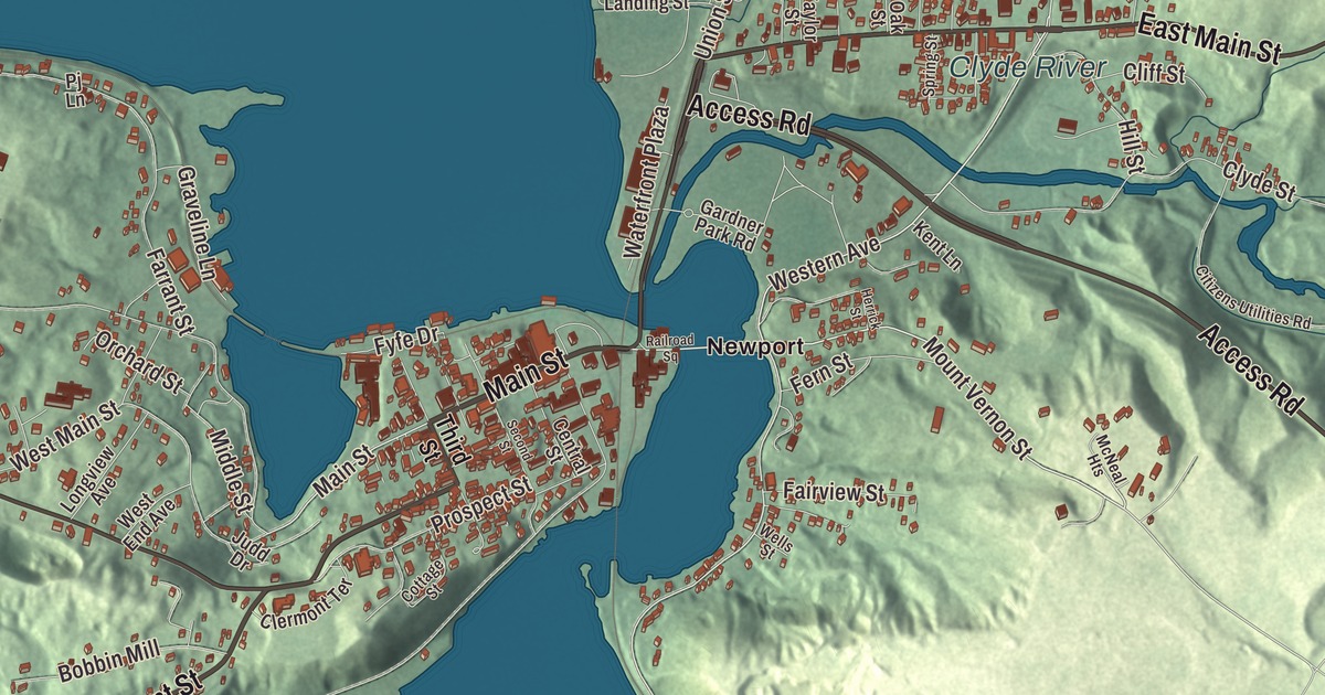
Newport wraps around the southern shore of Lake Memphremagog, where three of the county’s four major rivers, the Clyde, the Barton and the Black, empty into the lake. This map prints Main Street, Pleasant Street, Access Road, East Main Street, Coventry Street and Highland Avenue across the city.
Newport City is a city in Orleans County, Vermont.
KNOWOL made this map in 2026 from public survey data and gave it the look of an old county atlas, shading the hills from United States Geological Survey elevation data and drawing the streets and city line from the Census Bureau. The city covers 7.6 square miles, 1.6 of them water, and 4,455 people lived here at the 2020 census. It’s the only city in Orleans County and the county’s shire town. Click here to purchase a print of this map for your wall.
Pickerel Point, then Lake Bridge
Settlers founded the place in 1793 and first called it Pickerel Point; later it took the name Lake Bridge, for its spot at the head of the lake. The peninsula where downtown stands was marshy wilderness until 1820, when it was cleared of timber, and in 1832 a bridge was built from it to the lake’s eastern shore, carrying the main road from Derby to Burlington. The railroad reached Newport in 1863, and the quiet farming place turned into a busy lumber town and a stop for lake tourists. The lumber firm Prouty & Miller started in 1865 and ran for more than 100 years, closing in the 1980s. Lake Bridge was incorporated as the Village of Newport in 1868, and in 1917 that village joined the village of West Derby to form the City of Newport, which organized on March 5, 1918.
On the lake
The steamboat Lady of the Lake began carrying passengers in 1867 and ran until 1917, and the city uses her as its logo. In 1873 the Bellevue Hotel opened with room for 75 guests and later grew to hold 100; renamed the Newport House, it was torn down in 1973. A light tower, the Newport Wharf Light, was built in the lake in 1879 and has since been demolished. From 1936 to 1953 the International Club had a dance floor 220 by 60 feet, big enough for 2,000 dancers, which the city’s page calls the largest in New England, and performers traveling by train between Boston and Montreal stopped to play it, among them Louis Armstrong, Cab Calloway, Rosemary Clooney, Jimmy and Tommy Dorsey, Glenn Miller and Louis Prima.
Downtown on the peninsula
Downtown still sits on the original village’s small peninsula, jutting east into the southernmost finger of the lake, and most of it makes up the Newport Downtown Historic District, roughly bounded by Third Street, Coventry Street and the lake and listed on the National Register of Historic Places in 2006. In 1886 the legislature moved the county seat here from Irasburg, and the Orleans County Courthouse went up that year on Main Street, a Romanesque brick building with a clock tower designed by the local architect Lambert Packard. Just east of it stands the Federal Building, finished in 1904 to hold the courts, the post office and the customs offices, and still the city’s tallest building; across Main Street, the former National Guard armory serves as city hall. The Goodrich Memorial Library at 202 Main Street, paid for by Converse and Almira Goodrich, was dedicated on September 1, 1899, and opened with 6,500 books. It’s a Romanesque building with fireplaces of colored brick, and a wall of glass cases inside holds stuffed animals and natural curiosities, from an alligator to an ostrich egg.
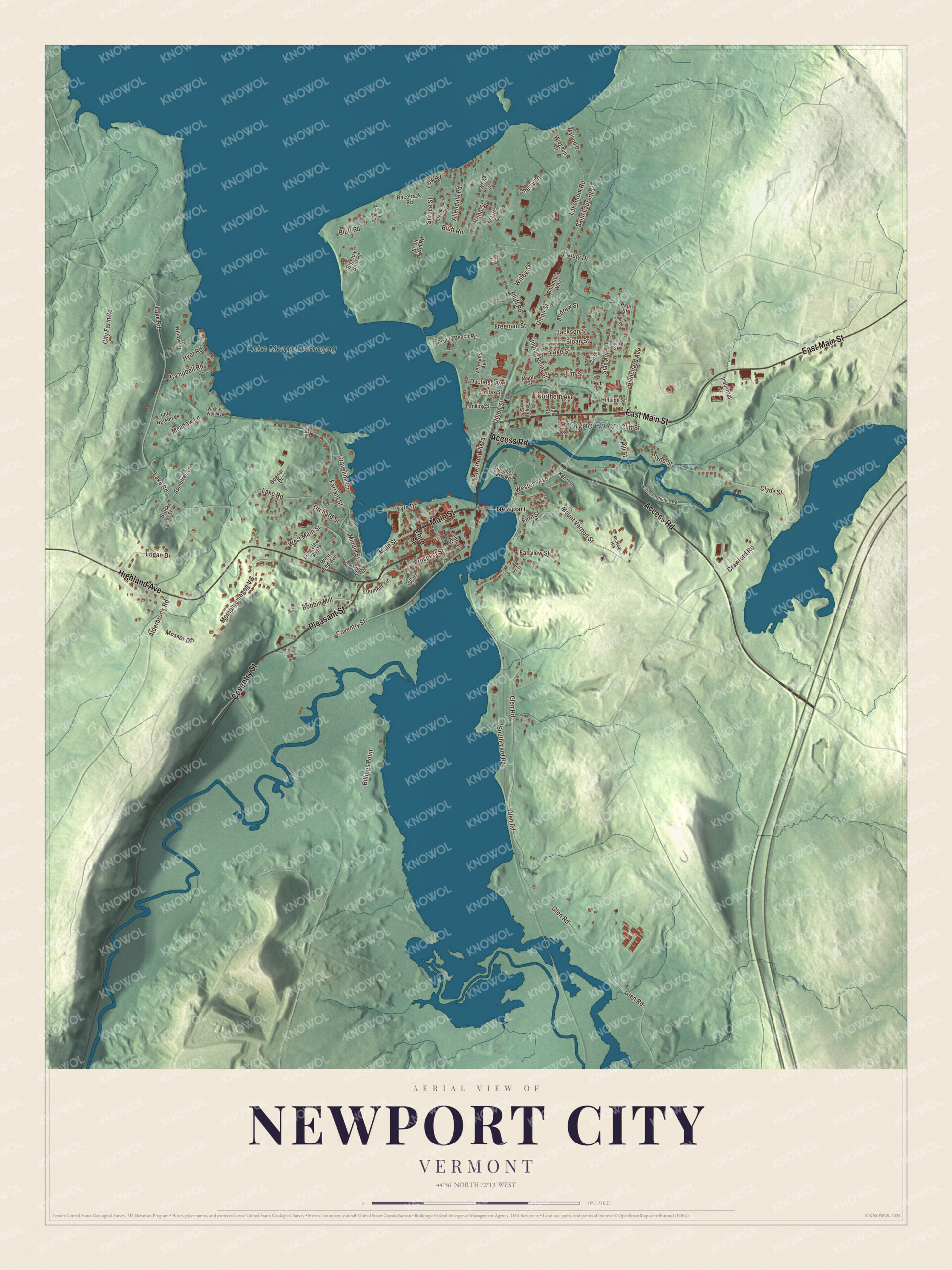
Click to explore a larger preview. The digital watermark does not appear on printed maps.
Names on this map
These names are printed on this map.
Places: Clyde River, Lake Memphremagog and Newport.
Streets and roads: Main Street, Pleasant Street, Access Road, East Main Street, Coventry Street, Highland Avenue, Western Avenue, Mount Vernon Street, Sias Avenue, Glen Road, Lake Road, Bluff Road.
More street names, A to Z
Alderbrook Road, Allendale Road, Andrew Street, Appletree Lane, Bigelow Bluff Road, Billings Point, Birch Lane, Blake Street, Blanchard Avenue, Bobbin Mill, Bogner Drive, Brooks Street, Campbell Road, Central Street, Cherry Lane, Citizens Utilities Road, City Farm Road, Clermont Terrace, Cliff Street, Clover Lane, Clyde Street, Colfax Street, Columbia Way, Cottage Street, Cove Road, Crawford Road, Duchess Avenue, Elm Street, Estates Drive, Fairview Street, Farrant Street, Fern Street, Freeman Street, Fyfe Drive, Gardner Park Road, Graveline Lane, Heron Lane, Herrick Street, Hillside Street, Hill Street, Hyer Road, Indian Point Street, Industrial Drive, Jackson Street, Judd Drive, Kent Lane, Lakemont Road, Landing Street, Logan Drive, Longview Avenue, Loop Road, Lord Nelson Lane, Mallard Drive, Maple Street, McNeal Heights, Meadow Lane, Memphremagog Vw, Middle Street, Mosher Drive, Northern Avenue, Oak Street, Orchard Street, Paddock Lane, Paul Street, Pearl Street, Penny Lane, Pine Street, Pj Lane, Poutre Street, Prospect Street, Prouty Beach Road, Prouty Drive, Racetrack Road, Railroad Square, Saint Laurent Street, Scott Farm Road, Second Street, Sloan Street, South Yard Road, Spring Street, Spruce Street, Stagecoach Drive, Taylor Street, Temple Street, Third Street, Union Street, Veterans Avenue, Waterfront Plaza, Wells Street, West End Avenue, West Main Street, Widgeon Drive, Willey Street, Willow Lane, Wishing Well Avenue.
See it on a wall
The Newport City map as a framed print. Swipe for more.


Highland Avenue, Main Street and Access Road
Highland Avenue is Route 105, the road west out of the center of the city. At 68 Highland Avenue, an apartment house built about 1919 for workers in the city’s growing industries still wears its original pressed-metal siding, a rare survivor that was listed on the National Register in 2000. On Main Street west of downtown, the Ai J. White Duplex, built about 1897 by a French Canadian immigrant who made window sashes and blinds in a shop behind it, is a well-kept Queen Anne double house. Access Road is Route 191, which comes in from Interstate 91 at Exit 27 and widens to four lanes for its last half mile into the heart of the city.
Newport people
George H. Prouty, born in Newport in 1862, worked in the family’s Prouty & Miller business and was governor of Vermont from 1908 to 1910. His nephew Winston L. Prouty, also born here, served as mayor of Newport from 1938 to 1941 and then represented Vermont in Congress from 1951 and in the United States Senate from 1959 until his death in 1971. Duane Graveline, born in Newport in 1931 and a 1948 graduate of Newport High School, became a physician and one of the six scientists NASA chose in 1965 for its fourth group of astronauts. Lane Dwinell, born here in 1906, went on to serve as governor of New Hampshire from 1955 to 1959.
On the map, start at Newport, then follow Main Street, Pleasant Street, Access Road, East Main Street, Coventry Street and Highland Avenue across the city. The Clyde River and Lake Memphremagog are printed. Newport City dates to 1917.
This map of Newport City is made for everyone who calls Newport City home, and it shows the city as it looks today, from the downtown peninsula to the shore of Lake Memphremagog. Hang it in an office, library or den, or use it to teach children the geography and history of their city. It’s printed on museum quality archival paper. Zoom in on the preview above to explore the details, then click here to get your copy of the Newport City, Vermont map.

Sources
- Newport (city), Vermont, Wikipedia
- Town histories and representatives, N towns, Vermont Legislature
- Newport Downtown Historic District, Wikipedia
- Orleans County Courthouse and Jail Complex, Wikipedia
- U.S. Courthouse, Post Office and Customs House (Newport, Vermont), Wikipedia
- Goodrich Memorial Library, Wikipedia
- House at 68 Highland Avenue, Wikipedia
- Ai J. White Duplex, Wikipedia
- Vermont Route 191, Wikipedia
- George H. Prouty, Wikipedia
- Winston L. Prouty, Wikipedia
- Duane Graveline, Wikipedia
- Lane Dwinell, Wikipedia