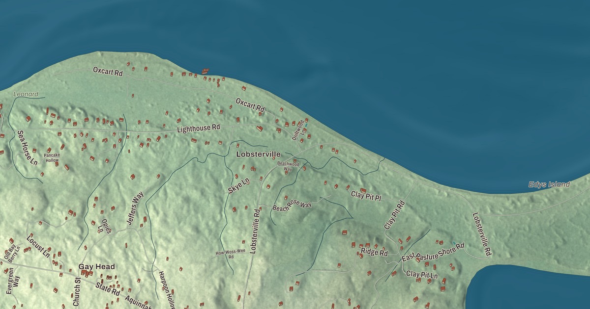
Aquinnah is the western end of Martha’s Vineyard, and the only road into town runs between two salt ponds. This map prints State Road, Moshup Trail, Lighthouse Road, Lobsterville Road, East Pasture Shore Road and Aquinnah Circle, with Menemsha Pond and Squibnocket Pond on the town’s eastern edge, Black Pond and Edys Island. Click here to purchase a print of this map for your wall.
Aquinnah is in Dukes County, on the island of Martha’s Vineyard.
KNOWOL made this map in 2026 from public survey data and gave it the look of an old atlas. The shaded terrain comes from United States Geological Survey elevation data, over rolling heathland, woods, high dunes and the famous clay cliffs. The roads and the town line come from the Census Bureau. Most of the town is water: of its 40.8 square miles, only 5.4 are land, and it’s the smallest Vineyard town by land area. Aquinnah had 439 people at the 2020 census.
Land under the hill
Aquinnah is a center of Wampanoag culture and the home of the Wampanoag Tribe of Gay Head (Aquinnah). Archaeologists date the earliest signs of people here to between 10,000 and 7,500 years ago, and the tribe’s own story says their ancestors reached the island on an ice floe from the far north. The Wampanoag were whalers harpooning from small boats long before commercial whaling became the major sea trade of the Vineyard, Nantucket and New Bedford, and Herman Melville made Tashtego, a harpooner in Moby-Dick, a man from Aquinnah. In 1902 a Wampanoag whaleman, Amos Smalley, harpooned a white sperm whale south of the Azores from the New Bedford bark Platina, and he was invited to the opening of the movie Moby Dick.
The Town of Aquinnah’s recorded history dates European settlement to 1669, in the state’s list. Aquinnah was incorporated as a town in 1870, divided from Chilmark under the name Gay Head, for the bright colors of its cliffs. The tribe won federal recognition in 1987, and in 1997, by a vote of 79 to 76, the town changed its name to Aquinnah, Wampanoag for “land under the hill.” Wampanoag people make up about a third of the town’s voters, and 485 acres of tribal land are held in trust for the tribe. The town remains part of Dukes County today.
The cliffs and the light
The clay cliffs at Gay Head were named a National Natural Landmark by the National Park Service in 1965. They belong to the tribe and are protected jointly with the town and two island land groups, and rangers explain to visitors what the cliffs mean to the Wampanoag. Below them is Moshup Beach, named for a great sachem said to have shaped much of the island’s landscape; the clay sometimes tints the water red, white or gray. Aquinnah Circle has been named a cultural and historical site, and the tribe’s page calls it the nation’s first town-tribe partnership.
Gay Head Light, off Lighthouse Road, stands on the Vineyard’s westernmost point. Congress authorized a light here in 1798 to guard ships from Devil’s Bridge, a reef of underwater rocks, and the first tower, built of wood in 1799, was the first lighthouse on Martha’s Vineyard. Today’s light is red brick, and in 2015, with the cliff edge wearing away, it was moved 129 feet inland. Click here to learn more about the history of Aquinnah.
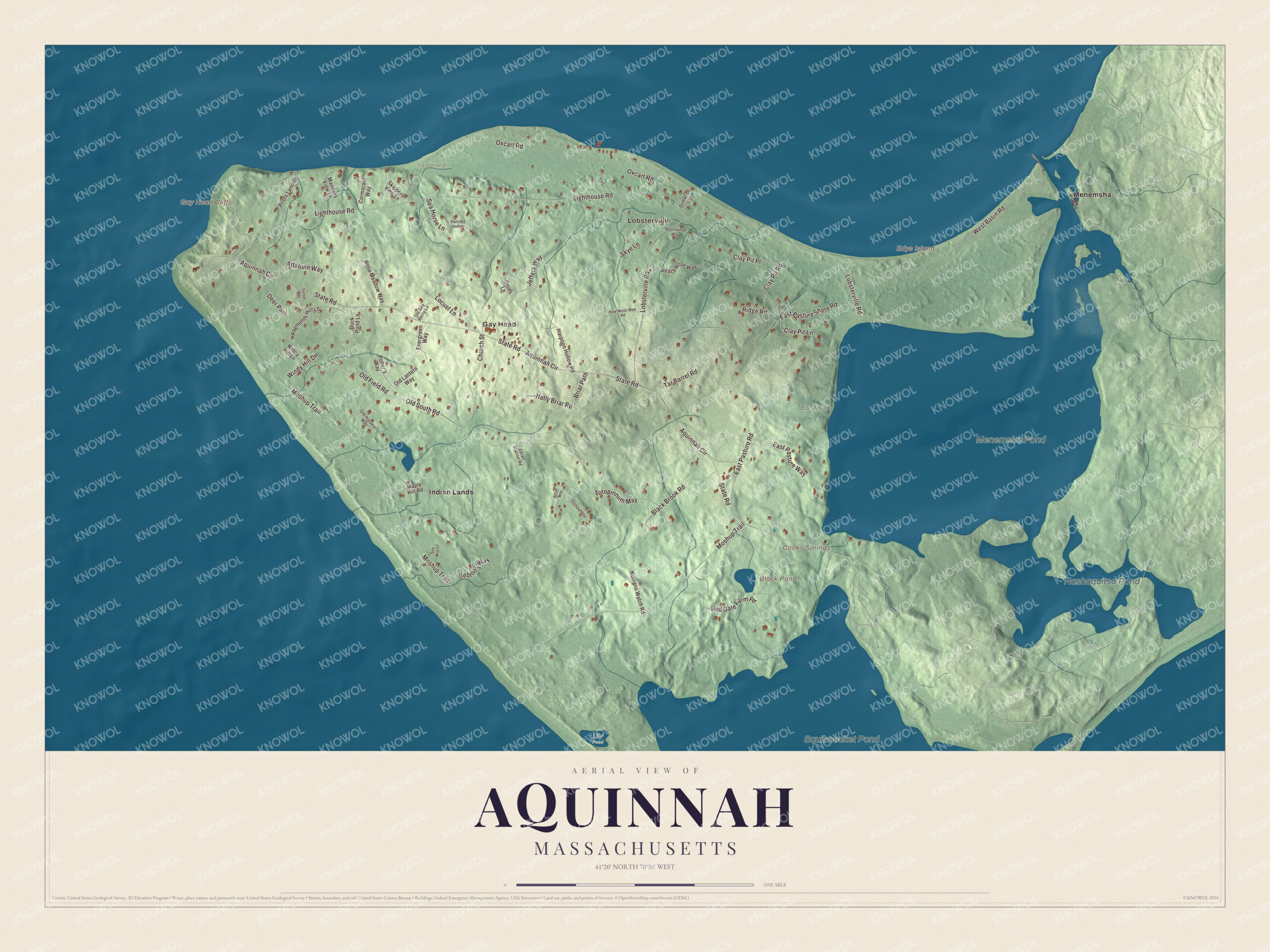
Click to explore a larger preview. The digital watermark does not appear on printed maps.
Names on this map
These names are printed on this map.
Places: Lobsterville, Gay Head, Edys Island, Gay Head Cliffs, Black Pond, Cooks Springs, Squibnocket Pond, Menemsha Pond, Nashaquitsa Pond, Eastman, Leonard, Lily Pond, Indian Lands and Menemsha.
Streets and roads: State Road, East Pasture Shore Road, Moshup Trail, Aquinnah Circle, Lighthouse Road, Lobsterville Road, Old South Road, West Basin Road, East Pasture Road, Oxcart Road, Totopinnum May, Red Gate Farm Road.
More street names, A to Z
Ahtuk May, Attaquin Way, Beach Rose Way, Beachwood Way, Black Brook Road, Briar Path, Church Street, Clay Pit Lane, Clay Pit Place, Clay Pit Road, Cormorant Way, Deer Path, Driftwood Lane, Duck Pond Lane, East Pasture Way, Evergreen Way, Harpoon Hollow Road, Hebron's Way, Holly Briar Road, How-Woss-Wee Road, Jeffers Way, Locust Lane, Loran Station Road, Maple Hill Road, Mariners View Lane, Nomans Watch Road, Old Bay Berry Lane, Old Field Road, Old Harvest Way, Old Lantern Way, Oonouhkoi, Opies Lane, Pancake Hollow, Pilots Landing, Potter's Way, Raymonds Hill Lane, Ridge Road, Rose Meadow Way, Sea Horse Lane, Sea Mist Lane, Skippers View Lane, Skye Lane, Sunset Way, Tar Barrel Road, Windy Hill Drive, Windy Hill Lane.
See it on a wall
The Aquinnah map as a framed print. Swipe for more.


Salt ponds and the north shore
Menemsha Pond and Squibnocket Pond are salt ponds split between Aquinnah and Chilmark, and they’re joined by Herring Creek, a herring run the Wampanoag have fished since time out of mind. Each spring blueback herring and alewives swim in from the ocean through Menemsha Pond to spawn in Squibnocket, and the tribe keeps the creek, with a hatchery, and raises oysters on Menemsha Pond. The tribe gives the meaning of Squibnocket’s name as “at the place of the red cliff or bank” in its own language. Black Pond, Edys Island and Cooks Springs are printed on the map too. Lobsterville Beach, on the north shore at Dogfish Bar, is known for surf fishing, and Philbin and Moshup beaches are off Moshup Trail. Start with Lobsterville, follow State Road, East Pasture Shore Road, Moshup Trail, Aquinnah Circle, Lighthouse Road or Lobsterville Road across town, then look outward toward Gay Head, Indian Lands and Menemsha. Menemsha is a fishing village in the neighboring town of Chilmark, across the pond, and a bike ferry crosses to it from Aquinnah.
This Aquinnah map belongs in an office, library or den, and it can help teach children the geography and history of the Wampanoag homeland at the western end of Martha’s Vineyard. It’s made for people who call Aquinnah home, from the cliffs to Lobsterville. KNOWOL created it in 2026, and it’s printed on museum quality archival paper. Zoom in on the preview above to explore the details, then click here to get your copy of the Aquinnah, Massachusetts map.

Sources
- Aquinnah, Massachusetts, Wikipedia
- Wampanoag Tribe of Gay Head, Wikipedia
- Amos Smalley, Wikipedia
- Gay Head Light, Wikipedia
- Squibnocket Pond, Wikipedia
- Menemsha Pond, Wikipedia
- Menemsha, Massachusetts, Wikipedia
- City and Town Incorporation and Settlement Dates, Secretary of the Commonwealth of Massachusetts (archived copy)