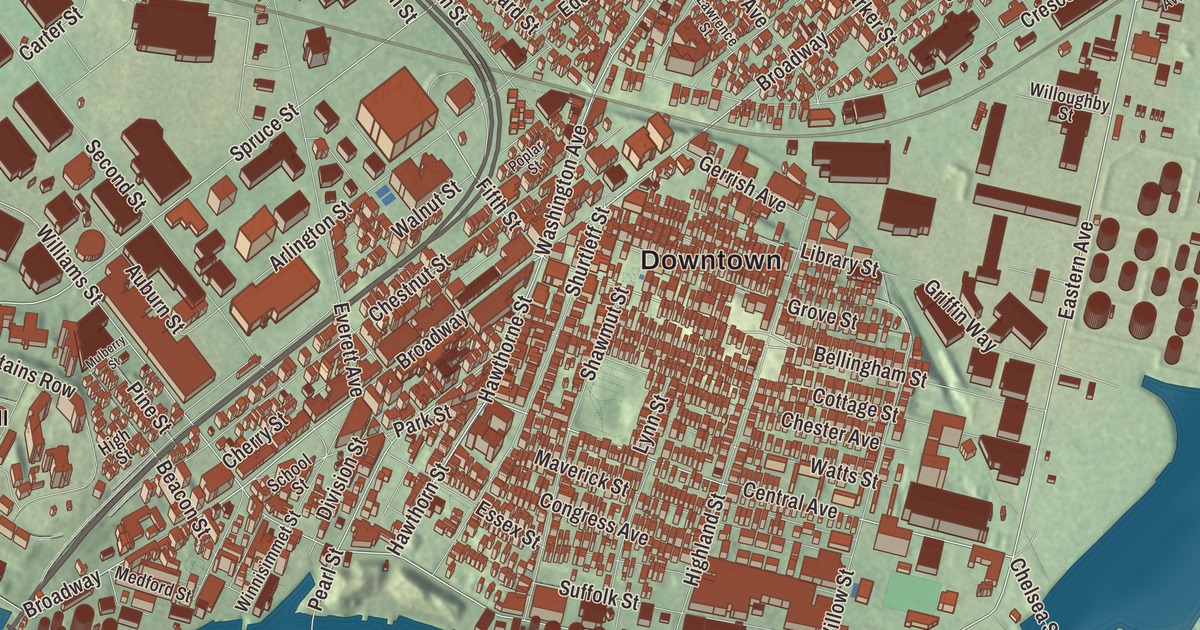
Chelsea is the smallest city in Massachusetts by land area, tied to Boston by the Tobin Bridge, with Broadway through the middle and water on three sides. This map prints Broadway, Washington Avenue, Eastern Avenue, Marginal Street, Commandants Way and the Revere Beach Parkway, with Admirals Hill, Breeds Hill and the Atlantic Ocean. Click here to purchase a print of this map for your wall.
Chelsea is in Suffolk County, across the Mystic River from Boston.
KNOWOL made this map in 2026 from public survey data and gave it the look of an old atlas. The relief comes from United States Geological Survey elevation data, and the streets and the city line come from the Census Bureau. Chelsea covers 2.21 square miles on a small peninsula in Boston Harbor. The Island End River divides it from Everett, the Mystic River and Chelsea Creek from Boston, and Mill Creek marks part of the Revere line. Most of the city lies close to sea level, but glacial drumlins rise among the streets: Admirals Hill, Mount Bellingham, Powderhorn Hill, Mount Washington and Mill Hill, and they help divide the neighborhoods.
Winnisimmet
The Naumkeag people, who had lived here for thousands of years, called the place Winnisimmet, “swamp hill.” The City of Chelsea’s recorded history, in the Secretary of the Commonwealth’s list, dates European settlement to 1624, when Samuel Maverick became the first European to settle here for good. His palisaded trading post is considered the first permanent settlement in Boston Harbor. In 1635 he sold all of Winnisimmet except his own house and farm to Richard Bellingham, later governor of the colony, and the land stayed part of Boston until Chelsea was incorporated as a town in 1739, named for the Chelsea neighborhood of London. North Chelsea, which became Revere and Winthrop, split off in 1846, and Chelsea was incorporated as a city in 1857. It remains part of Suffolk County today.
Chelsea Creek and the Navy
On May 27 and 28, 1775, the Battle of Chelsea Creek was fought here, the second military engagement of the Boston campaign. Colonial forces cleared livestock and hay off the harbor islands out of British reach and captured and destroyed the armed schooner Diana, the first naval capture of the war, and part of George Washington’s army was stationed in Chelsea during the Siege of Boston. In 1836 the Chelsea Naval Hospital opened on a hill above the Mystic River, built of Vermont granite and designed by Alexander Parris. It was one of the first three hospitals Congress authorized for Navy personnel, and when it closed in 1974 it was the oldest naval hospital in service in the country; John F. Kennedy was a patient there before his presidency. The hospital stood on the south slope of Admirals Hill, and its old buildings are now homes, with Mary O’Malley Park, the city’s largest, between them and the shore.
A city of newcomers
By the middle of the 19th century Chelsea was building wooden sailing ships, and later its factories made rubber and elastic goods, boots and shoes, stoves and adhesives. Nathan Morse, the first Jewish resident on record, arrived in 1864, and after 1890 Chelsea became a major destination for Jewish immigrants from Russia and Eastern Europe. By the 1930s about 20,000 of its nearly 46,000 people were Jewish, and the city page says it may have had more Jewish residents per square mile than any American city outside New York. By 1919, 46 percent of the city’s people had been born abroad.
Chelsea has given the country some remarkable people. Lewis Howard Latimer was born here in 1848 to Rebecca and George Latimer, who had escaped slavery in Virginia, and he grew up to be an inventor and patent draftsman. He drew the patent drawings for Alexander Graham Bell’s telephone, patented an improved way of making carbon filaments for electric light bulbs, wrote the first book on electric lighting, and in 1918 became the first person of color to join the Edison Pioneers. The writer Horatio Alger was born in Chelsea in 1832, and Annette Rogers, born here in 1913, won two Olympic gold medals in the relay, setting a world record in 1932. The Chelsea Clock Company, founded in 1897, still builds and repairs clocks at its headquarters in Chelsea, and its clocks have hung in the White House and on Navy ships.
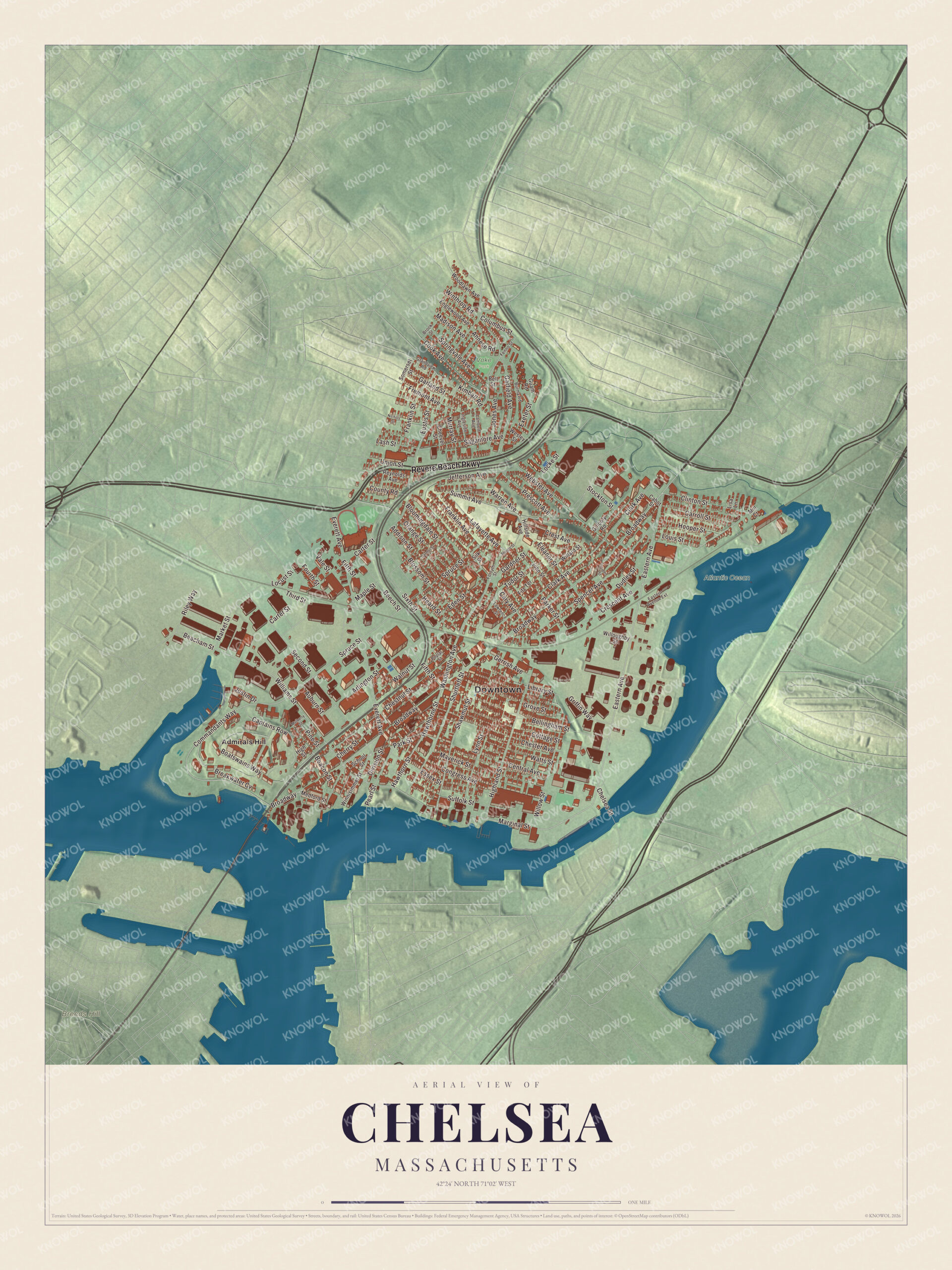
Click to explore a larger preview. The digital watermark does not appear on printed maps.
Names on this map
These names are printed on this map.
Places: Downtown, Breeds Hill, Atlantic Ocean, Voke Park and Admirals Hill.
Streets and roads: Revere Beach Parkway, Broadway, Washington Avenue, Eastern Avenue, Marginal Street, Commandants Way, Central Avenue, Clinton Street, Fifth Street, Hawthorne Street, Hawthorn Street, Bellingham Street.
More street names, A to Z
Addison Street, Annese Road, Arlington Street, Auburn Street, Beacham Street, Beacon Street, Beech Street, Bell Street, Bloomingdale Street, Blossom Street, Boatswains Way, Breakwater Cv, Brook Street, Burma Road, Cabot Street, Captains Row, Carmel Street, Carroll Street, Carter Street, Cary Avenue, Cheever Street, Chelsea Street, Cherry Street, Chester Avenue, Chestnut Street, Clark Avenue, Columbus Street, Congress Avenue, Cook Avenue, Cottage Street, County Road, Crescent Avenue, Crest Avenue, Division Street, Dudley Street, Eastern Avenue Extension, Eden Street, Eleanor Street, Englewood Avenue, Essex Street, Eustis Street, Everett Avenue, Exeter Street, Fenno Street, Fitz Terrace, Forsyth Street, Fourth Street, Franklin Avenue, Franklin Street, Fremont Avenue, Gardner Street, Garfield Avenue, Garland Street, Gerrish Avenue, Gillooly Road, Grandview Road, Green Street, Griffin Way, Grove Street, Guam Road, Heard Street, Highland Street, High Street, Hillside Avenue, Hooper Street, Ingleside Avenue, Jefferson Avenue, John Street, Jones Avenue, Justin Drive, Kimball Road, Lafayette Avenue, Lambert Avenue, Lash Street, Lawrence Street, Library Street, Lisa Lane, Locke Street, Locust Street, Louis Street, Lynn Street, Madison Avenue, Maple Street, Market Street, Maverick Street, Medford Street, Mill Court, Mulberry Street, Murray Street, Nichols Street, Orange Street, Parker Street, Park Street, Pearl Street, Pine Street, Poplar Street, Prescott Avenue, Reynolds Avenue, Riley Way, Sagamore Avenue, School Street, Second Street, Shawmut Street, Shurtleff Street, Silk Street, Sixth Street, Somerset Street, Spencer Avenue, Springvale Avenue, Spruce Street, Stockton Street, Sturgis Street, Suffolk Street, Summit Avenue, Third Street, Tudor Street, Union Street, Vale Street, Walnut Street, Warren Avenue, Watts Street, Webster Avenue, Wesley Street, Willard Street, Williams Street, Willoughby Street, Willow Street, Winnisimmet Street, Winthrop Road, Woodlawn Avenue.
Around the map
Start on Admirals Hill, then follow the Revere Beach Parkway, Broadway, Washington Avenue, Eastern Avenue, Marginal Street and Commandants Way across the city. Bellingham Square, where Broadway, Washington Avenue and three other streets meet, is the civic and commercial heart of Chelsea, rebuilt after the Great Chelsea Fire of 1908 as a planned district with City Hall, the public library and the old post office by leading architects. Powderhorn Hill is topped by the Soldiers Home, a state-run home for veterans. The Revere Beach Parkway, built between 1896 and 1904 as one of the first parkways proposed by the landscape architect Charles Eliot, winds through the north of the city on its way to Revere Beach. Chelsea Creek, 2.6 miles long and one of 10 designated port areas in Massachusetts, is where all the jet fuel used at Logan Airport is stored. Breeds Hill, across the Mystic in Charlestown, is where most of the fighting in the Battle of Bunker Hill took place. The Atlantic Ocean and Breeds Hill are both printed on the map.
Chelsea’s map makes a fine addition to an office, library or den, and it can help teach children the geography and history of a small city with a big story. It’s made for people who call Chelsea home, from Admirals Hill to Mill Hill, and it shows the city as it looks today. Zoom in on the preview above to explore the details, then click here to get your copy of the Chelsea, Massachusetts map.

We made a map for every town and city in Massachusetts. Explore the complete Massachusetts map collection and find your town.
Sources
- Chelsea, Massachusetts, Wikipedia
- Battle of Chelsea Creek, Wikipedia
- Naval Hospital Boston, Wikipedia
- Lewis Howard Latimer, Wikipedia
- Horatio Alger, Wikipedia
- Annette Rogers, Wikipedia
- Chelsea Clock Company, Wikipedia
- Bellingham Square Historic District, Wikipedia
- Revere Beach Parkway, Wikipedia
- Chelsea Creek, Wikipedia
- Battle of Bunker Hill, Wikipedia
- City and Town Incorporation and Settlement Dates, Secretary of the Commonwealth of Massachusetts (archived copy)