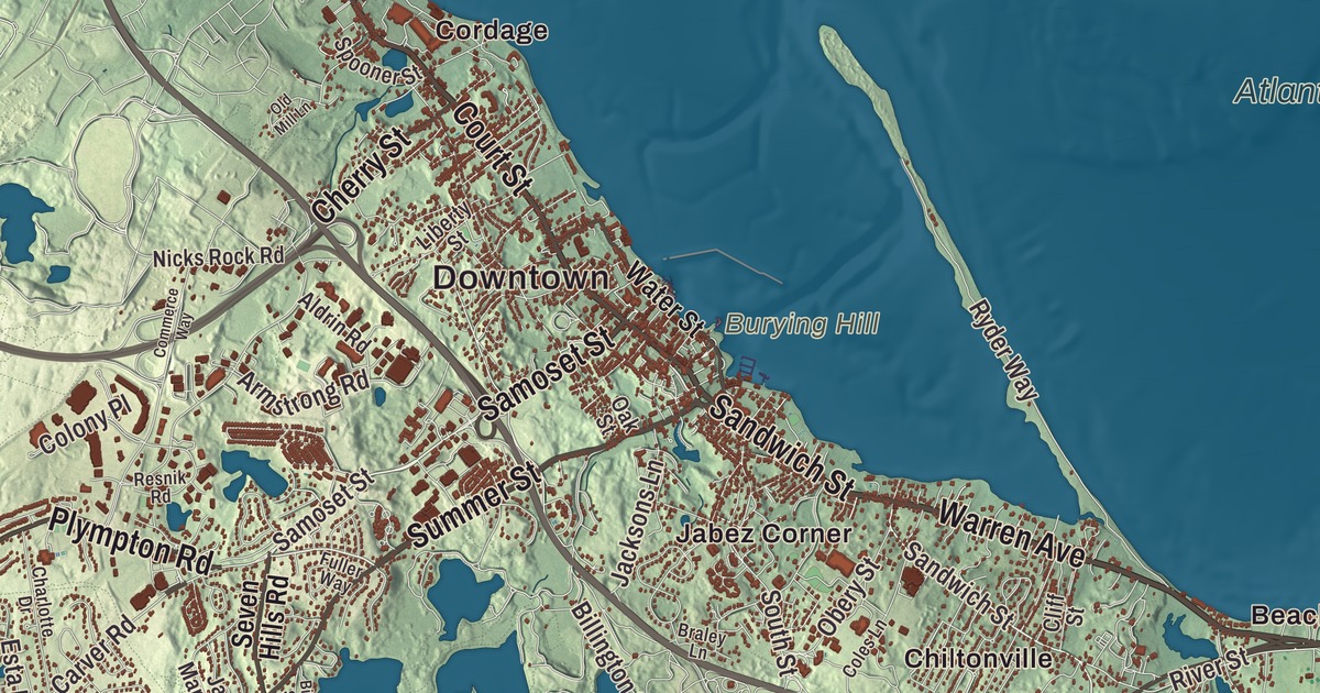
Long before the Mayflower, this shore was Patuxet, a Wampanoag village. This map of Plymouth prints Court Street, Summer Street, Sandwich Street, Samoset Street, Warren Avenue and State Road, and it reaches from Bayside Beach and Beach Point on the Atlantic Ocean back to Great Herring Pond, Abner Pond and Allens Pond in the woods. Click here to purchase a print of this map for your wall.
Plymouth is in Plymouth County.
KNOWOL made this map in 2026 from public survey data and gave it the look of an old atlas. The land comes from United States Geological Survey elevation data, and the streets and the town line come from the Census Bureau. Plymouth is the largest municipality in Massachusetts by area, 134.0 square miles, 37.5 of them water, and it makes up the entire western shore of Cape Cod Bay. Its coast is low and flat, while its western sections are hilly and wooded and dotted with small ponds. It had 61,217 people at the 2020 census, and it’s known as “America’s Hometown.”
Patuxet
The Patuxet were a band of the Wampanoag confederation, and they lived in and around what’s now Plymouth. Their cleared and planted fields were a primary reason the English chose this site. Between 1614 and 1620, epidemics swept the coast, and by 1620 every Patuxet but one had died. In 1614 an English captain, Thomas Hunt, kidnapped several Wampanoag to sell in Spain; one of them was a Patuxet man named Tisquantum, whom the English came to call Squanto. He won back his freedom, worked his way to England, and made it home in 1619 to find that disease had killed everyone in his village.
The Mayflower’s passengers came ashore here on December 21, 1620. The Town of Plymouth’s recorded history dates European settlement to 1620. Plymouth was incorporated as a town that same year. The town remains part of Plymouth County today. About half of the 102 settlers died in that first winter. The colony depended on Native help from the start. Samoset, an Abenaki sachem from Maine who had learned English from fishermen, came first, and then Tisquantum, who taught the colonists how to grow corn and where and how to catch fish and was instrumental in their survival for the first two years. The Wampanoag sachem Ousamequin, known by his title Massasoit, made a peace treaty with the colonists on March 22, 1621, and according to English sources his help kept Plymouth Colony from failing and starving in its earliest years. After a good harvest that fall, the colonists gathered with Squanto, Samoset, Massasoit and ninety Wampanoag men in the celebration now known as the First Thanksgiving.
Plymouth was the capital of Plymouth Colony until 1691 and is the first permanent European settlement in New England. On Cole’s Hill, rising from the shore of Plymouth Bay, stands Cyrus Dallin’s statue of Massasoit. In 1970, on the 350th anniversary of the landing, Frank “Wamsutta” James, leader of the Wampanoag Tribe of Gay Head, was invited to speak at the state’s Thanksgiving celebration, and then told he couldn’t give the speech he’d written. He gave an amended version on Cole’s Hill instead, beside the statue, on Thanksgiving Day, November 26, 1970, to close to 500 Native Americans from across the country. The National Day of Mourning, organized by the United American Indians of New England, has been held there on the fourth Thursday in November every year since, to teach the public about the Wampanoag and other Native peoples.
America’s Hometown
Plymouth Rock is traditionally said to be where the Pilgrims first stepped ashore, though no historical evidence supports it. Thomas Faunce, 94 years old, first named it as the landing place in 1741. The rock was moved, split in two along the way, and returned to the waterfront in 1921, where it rests under a granite portico by McKim, Mead and White at the center of Pilgrim Memorial State Park, the smallest park in the state system and its most heavily visited. Pilgrim Hall Museum on Court Street opened in 1824 in a building by Alexander Parris, and it’s called the oldest public museum in the United States in continuous operation. Plimoth Patuxet, opened in 1947 as Plimoth Plantation, re-creates the English village of 1627 and has kept a Wampanoag Homesite since 1973, where Native people from a variety of tribes show how the Wampanoags’ ancestors lived. Its Mayflower II, built in Brixham, England, sailed across the Atlantic in 1957.
At Parting Ways, near the Kingston line on Route 80, four formerly enslaved men who fought in the Revolution, Cato Howe, Prince Goodwin, Plato Turner and Quamony Quash, founded a settlement of free Black families on 94 acres granted in 1792. Archaeologists studied the site in the 1970s, and part of the land is on the National Register. In the 1800s Plymouth became a center of rope making, fishing and shipping, and the Plymouth Cordage Company, founded in 1824, grew by the late 1800s into the largest maker of rope and twine in the world. It made the rope for the USS Constitution, its binder twine inspired the name of the Plymouth automobile, and it closed in 1964.
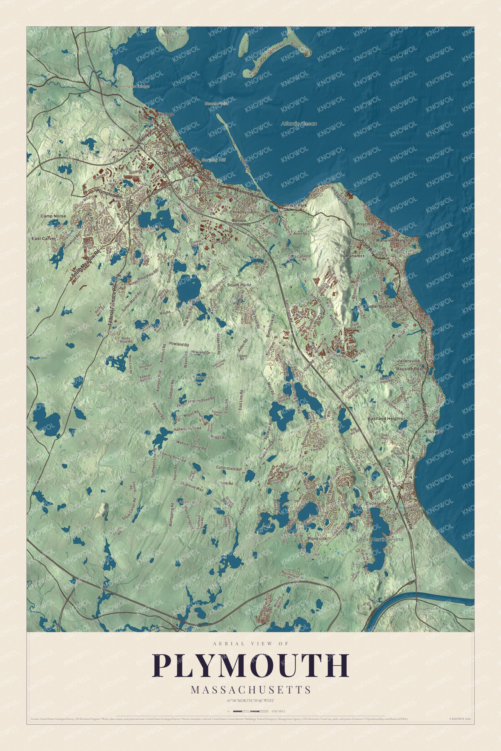
Click to explore a larger preview. The digital watermark does not appear on printed maps.
Names on this map
These names are printed on this map.
Places: Downtown, Bay Hill, Beach Point, Billington Ledge, Burying Hill, Abner Pond, Allens Pond, Great Herring Pond, Atlantic Ocean, Cr #4, Myles Standish State Forest, Bayside Beach, Beach Park, Camp Norse, Cedar Bushes, Cedarville, Chiltonville, Cordage, East Carver, Eastland Heights, Ellisville, Jabez Corner, Manomet, Manomet Heights, Pondville, Priscilla Beach, South Pond and Vallersville.
Streets and roads: Court Street, Warren Avenue, Summer Street, Sandwich Street, Samoset Street, State Road, Federal Furnace Road, South Meadow Road, Plympton Road, Cherry Street, Carver Road, Sandwich Road.
More street names, A to Z
Agawam Path, Agawam Road, Alden Road, Aldrin Road, Alewife Road, Arbor Ridge, Armstrong Road, Bare Hill Road, Barnfield Drive, Bartlett Road, Bay Farm Drive, Bearberry Path, Beaver Dam Road, Billington Sea Road, Billington Street, Birch Street, Black Cat Road, Black Pond Road, Blueberry Road, Bog Hill Road, Bog Road, Boot Pond Road, Boulevard, Bournehurst Drive, Bourne Road, Braley Lane, Briggs Road, Brook Road, Bruce Road, Bump Rock Road, Burgess Avenue, Camelot Drive, Cary Road, Cathedral Road, Center Hill Road, Central Avenue, Charge Pond Road, Charlotte Drive, Circle Drive, Circuit Drive, Clark Road, Clifford Road, Cliff Street, Cobb Road, Coles Lane, College Pond Road, Colony Place, Commerce Way, Conifer Hill, Cookes Pond Road, Cornish Field Road, Cove Road, Curlew Pond Road, Cuttersfield Road, Deer Hill Lane, Derek Drive, Doctors Pond Road, Dorothy Drive, Doten Road, Drew Road, East Line Road, Elbow Pond Road, Elliot Lane, Ellisville Drive, Ellisville Road, Esta Road, Fairview Lane, Fawn Pond Road, Fearing Pond Road, Federal Pond Road, Filmore Street, Fivemile Pond Road, Forge Drive, Fox Road, Fuller Way, Gallows Pond Road, Golf Drive, Graffam Road, Grassy Pond Road, Great Island, Gunners Exchange Road, Gunning Point Road, Halfway Pond Road, Haven Road, Haynes Road, Hedges Pond Road, Herring Pond Road, Herring Way, Hog Rock Road, Hollis Road, Howard Drive, Howland Drive, Howland Road, Indian Brook Road, Island Pond Road, Jacksons Lane, Janebar Circle, Janet Street, Jan Marie Drive, Jasons Lane, John Alden Road, Jordan Road, Joyce Drive, Kamesit Road, Kamesit Way, Kathleen Drive, Kings Pond Plain Road, Kristin Road, Lake Drive, Lake View Boulevard, Lantern Lane, Latham Wood, Liberty Street, Liggett Road, Line Road, Lisa Avenue, Little Sandy Pond Road, Long Pond Road, Long Ridge Road, Lookout Point Road, Lukes Way, Lunn's Way, Lunns Way, Manomet Avenue, Manomet Point Road, Maple Springs Road, Martingale Lane, Mast Road, May Hill Road, May Road, Meeting Way, Melix Avenue, Micajah Pond Road, Morey's Pond Road, Morgan Road, Morning Mist Lane, Nathan Lane, Negas Road, Negus Road, Nicks Rock Road, Oak Street, Oar and Line Road, Obery Street, Old Mill Lane, Old Ponds Road, Old Sandwich Road, Palmer Road, Pawtuxet Road, Peter Road, Pine Road, Pinewood Road, Pioneer Trail, Placid Bay Road, Plymouth Plantation Highway, Pokanoket Road, Pond Avenue, Quail Run, Reed Avenue, Resnik Road, River Run Way, River Street, Rocky Hill Road, Rocky Neck Road, Rocky Pond Road, Roxy Cahoon Road, Russell Mills Road, Ryder Way, Ryecroft, Sabbatia Road, Sacrifice Rock Road, Sanderson Road, Sandy Beach Road, Sasemine Way, Savery Road, Scarlet Drive, Scusset Road, Seabiscuit Drive, Seaview Drive, Seven Hills Road, Ship Pond Road, Shore Drive, Snake Hill Road, Sol Joseph Road, South Carver Road, Southeast Line Road, South Pond Road, South Street, Southwest Line Road, Spencer Drive, Spooner Street, Stage Point Road, Stonebridge Road, Strand Avenue, Suther Marsh Road, Taylor Avenue, Three Cornered Pond Road, Tihonet Road, Tower Hill Farm Road, Tower Road, Town Forest Road, Treetop Way, Upper College Pond Road, Valley Road, Wallwind Drive, Wampanog Road, Wareham Road, Watercourse Road, Water Street, Wayfarer Drive, Wayon Road, Webster Spring Road, West Line Road, West Long Pond Road, West Pond Road, White Cliff Drive, White Island Pond Road, White Trellis, Widgeon Pond Road, Winthrop Road.
Around the map
Start with Bayside Beach, then follow Court Street, Warren Avenue, Summer Street, Sandwich Street, Samoset Street and State Road across town. Then look outward toward Beach Park, Cedar Bushes, Cedarville, Chiltonville and Cordage. Abner Pond, Great Herring Pond, the Atlantic Ocean, Bay Hill, Burying Hill, Beach Point and Allens Pond are all printed on the map. On Summer Street, the Richard Sparrow House, built around 1640 by an English surveyor who came in 1636, is the oldest surviving house in Plymouth. On Sandwich Street, the Jabez Howland House, begun in 1667 and later bought by a son of Mayflower passengers John Howland and Elizabeth Tilley, is a museum. In North Plymouth, the old Plymouth Cordage factory is now the Cordage Commerce Center. Plimoth Patuxet stands in the northeastern part of Chiltonville. Great Herring Pond, 376 acres, lies mostly in Plymouth, with its southern end in Bourne, and the village of Pondville in Cedarville sits on its eastern shore. Abner Pond is a 10-acre pond inside Camp Cachalot, just east of Myles Standish State Forest, the second largest state forest in the Commonwealth.
The Plymouth map makes a fine addition to an office, library or den, and it can help teach children the geography and history of the town where Patuxet and Plymouth Colony stood. It’s made for people who call Plymouth home, from Cordage to Cedarville, and it shows the town as it looks today. Zoom in on the preview above to explore the details, then click here to get your copy of the Plymouth, Massachusetts map.

We made a map for every town and city in Massachusetts. Explore the complete Massachusetts map collection and find your town.
Sources
- Plymouth, Massachusetts, Wikipedia
- Patuxet, Wikipedia
- Massasoit, Wikipedia
- Cole’s Hill, Wikipedia
- National Day of Mourning (United States protest), Wikipedia
- Pilgrim Hall Museum, Wikipedia
- Plimoth Patuxet, Wikipedia
- Parting Ways (Plymouth, Massachusetts), Wikipedia
- Plymouth Cordage Company, Wikipedia
- Richard Sparrow House, Wikipedia
- Jabez Howland House, Wikipedia
- Chiltonville, Massachusetts, Wikipedia
- Great Herring Pond, Wikipedia
- Abner Pond, Wikipedia
- City and Town Incorporation and Settlement Dates, Secretary of the Commonwealth of Massachusetts (archived copy)