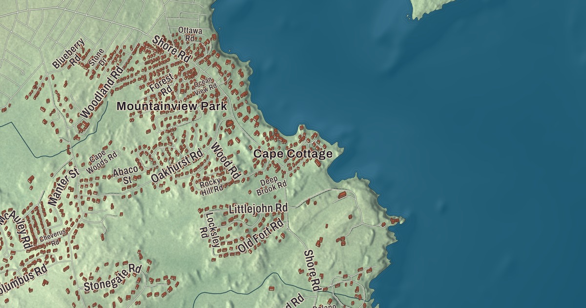
Shore Road, Spurwink Avenue, Bowery Beach Road, Ocean House Road and Sawyer Road carry their names on this map of Cape Elizabeth, along with Manter Street. Cape Cottage, Delano Park, Elizabeth Park, Mountainview Park and Pond Cove are printed too, and so are Great Pond and Little Pond. Click here to purchase a print of this map for your wall.
Cape Elizabeth is a town in Cumberland County, with 9,535 people at the 2020 census.
KNOWOL made this map in 2026 from public survey data and gave it the look of an old atlas. The relief is shaded from United States Geological Survey elevation data, and the roads and town line come from the Census Bureau. The bureau counts 45.93 square miles in Cape Elizabeth, and 31.23 of them are water, which leaves 14.70 square miles of land between South Portland to the north and Scarborough to the west.
Named by a king
Spanish explorers mapped this coast in 1525, and Bartholomew Gosnold arrived in 1602. When John Smith showed King Charles I his 1615 map, the king renamed the cape for his sister, Elizabeth of Bohemia, and the town’s page counts it among only four such royal renamings that survive. The first European settlement was a trading post on Richmond Island in 1628, which by 1638 had grown into a fishing and trading center with 60 men. George Cleeve and Richard Tucker started the first mainland settlement in 1630, near the Spurwink River.
Cape Elizabeth dates to 1765. On November 1 of that year it separated from Falmouth, now Portland, as Maine’s 23rd incorporated town, and it held its first town meeting on December 2. Its original lines took in everything south of Portland Harbor and east of the Spurwink. South Portland split off in 1895, when the north was growing into a business and industrial place and the south stayed rural.
Portland Head and Two Lights
Shore Road is printed on the map. Portland Head Light stands off it, at the entrance to Portland Harbor. George Washington set its building in motion in 1787, and two Falmouth masons, Jonathan Bryant and John Nichols, built the rubblestone tower, with Washington telling them to take the materials from the nearby fields and shores. It was first lit on January 10, 1791, and its page calls it the first lighthouse built by the United States government and the oldest lighthouse in Maine. Edward Hopper painted it in 1927. The Army began building a coast artillery post around the light in 1872 and named it Fort Williams in 1899, for Civil War Major General Seth Williams. When the fort closed in the 1960s the town bought the land, and Fort Williams Park now holds the light, its keeper’s house museum, the fort ruins and the ruins of the Goddard Mansion. Beckett’s Castle, a stone summer house with a three-story tower built in the 1870s by the Portland lawyer and writer Sylvester Beckett, stands at the end of a private lane off Shore Road.
The Cape Elizabeth Light station began in 1828 as two stone towers 300 yards apart, and the area is known as Two Lights for that history. In 1869 a steam fog whistle was set up there, which its page calls the first used in North America. In a snowstorm in January 1885, keeper Marcus A. Hanna threw a line again and again to two sailors trapped in the icy rigging of the schooner Australia, aground on the ledge, and with help from his assistant and two neighbors hauled them both to safety. Only the eastern tower still shines. Hopper painted one of the towers in 1929, and that picture went on a U.S. postage stamp in 1970.
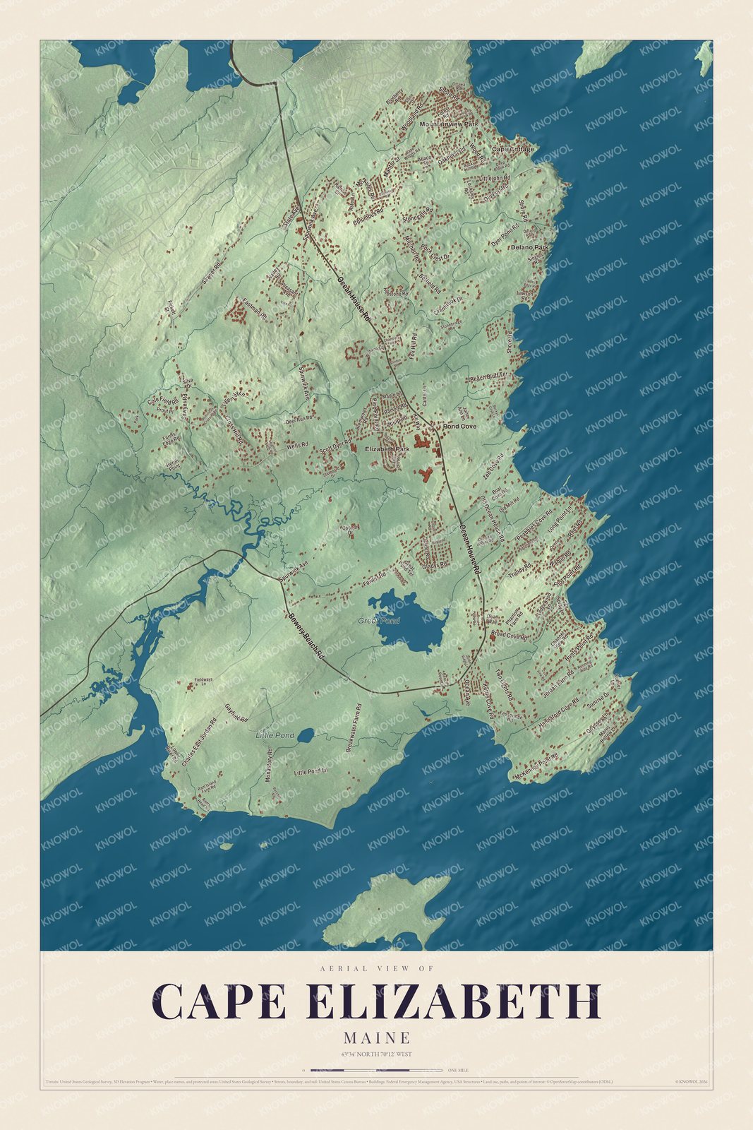
Click to explore a larger preview. The digital watermark does not appear on printed maps.
See it on a wall
The Cape Elizabeth map as a framed print. Swipe for more.


Spurwink Avenue and Sawyer Road
Spurwink Avenue and Bowery Beach Road are printed on the map. Where they meet, on a rise above the Spurwink River, stands the Spurwink Congregational Church. Built in 1802 and renovated in 1830, it’s the town’s oldest public building, and since 1957 the town has owned it and used it for community gatherings. Bowery Beach Road is part of State Route 77, which follows the coast through town. Sawyer Road is printed too. At 1148 Sawyer Road, the Dyer-Hutchinson Farm began in 1790, when William Dyer bought its first 9 acres. A town survey believes its house to be the oldest in western Cape Elizabeth. The Hutchinson family, who bought it in 1864, made boxes there in the early 1900s, and today it’s a Christmas tree farm.
Delano Park is printed on the map. At 9 Delano Park, just south of Portland Head Light, is the C. A. Brown Cottage, built in 1886 and the year after, an important Shingle Style house by the Portland architect John Calvin Stevens, built of wood shingles and fieldstone like the ledge it stands on. Cape Cottage is printed as well. The Cape Cottage Casino and Theater opened in 1899, one of several resorts along a new electric trolley line through South Portland and Cape Elizabeth.
Joan Benoit Samuelson was born in Cape Elizabeth. She won the first women’s Olympic marathon in 1984, and in 1998 she founded the Beach to Beacon 10K, which runs each August from Crescent Beach State Park to Portland Head Light and draws some of the world’s best distance runners. Robert Peary, the Arctic explorer, was raised in Cape Elizabeth. Ocean House Road and Manter Street are printed on the map, and so are Elizabeth Park, Mountainview Park, Pond Cove, Great Pond and Little Pond.
This Cape Elizabeth map makes a handsome addition to an office, library or den, and it can teach children the geography and history of a cape at the mouth of Portland Harbor. It’s made for anyone who calls Cape Elizabeth home, from Cape Cottage to Pond Cove, as it looks today. Zoom in on the preview above to explore the details, then click here to get your copy of the Cape Elizabeth, Maine map.

Sources
- Cape Elizabeth, Maine, Wikipedia
- List of municipalities in Maine, Wikipedia
- National Register of Historic Places listings in Cumberland County, Maine, Wikipedia
- Portland Head Light, Wikipedia
- Fort Williams Park, Wikipedia
- Beckett’s Castle, Wikipedia
- Cape Elizabeth Light, Wikipedia
- Spurwink Congregational Church, Wikipedia
- Maine State Route 77, Wikipedia
- Dyer-Hutchinson Farm, Wikipedia
- C. A. Brown Cottage, Wikipedia
- Joan Benoit, Wikipedia
- Beach to Beacon 10K, Wikipedia