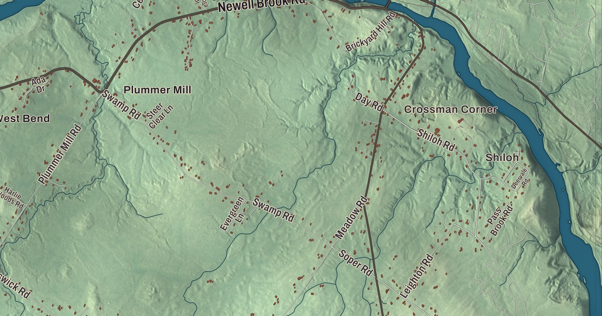
Royalsborough Road is the first name to find on this map of Durham, Maine, with South Durham, Shiloh and Crossman Corner. Hallowell Road, Runaround Pond Road, Pinkham Brook Road, Newell Brook Road and Auburn-Pownal Road fill in the rest, along with West Durham, Plummer Mill and South West Bend. Click here to purchase a print of this map for your wall.
Durham is a town in Androscoggin County, with 4,173 people at the 2020 census.
KNOWOL made this map in 2026 from public survey data and gave it the look of an old atlas. The Census Bureau measures the town at 39.04 square miles, 0.76 of them water, and its files give the roads and the town line. United States Geological Survey elevation data shades the hills, and Durham has a listed elevation of 171 feet.
Royallsborough to Durham
The town was first known as Royallsborough, after Isaac Royall Jr., and it took the name Durham when it was incorporated on February 17, 1789, after County Durham in England, the ancestral home of its first settler. Royalsborough Road, printed on the map, carries nearly the same name. In the 1760s the land belonged to the Pejepscot Proprietors, among them Jonathan Bagley, who served in the Revolutionary War. Today Durham borders Auburn, Lewiston, Lisbon, Topsham, Brunswick, Freeport, Pownal and New Gloucester, and it’s thought of as a “gateway” town between Greater Portland and Lewiston and Auburn.
Along Royalsborough Road
Three of Durham’s National Register places stand on Royalsborough Road, which is also Route 136. At 1290 Royalsborough Road in South Durham, the Bagley-Bliss House is traditionally dated to 1772 and claimed as the oldest house in town, although its Greek Revival look suggests a later date or a major renovation. O. Israel Bagley settled the property in 1770 and ran a grist mill, a shoe factory, the community’s first store and an inn from his house. Charles Bliss bought it in 1836 and started a dairy farm, and his family kept it into the 1970s.
Also in southern Durham, the Nathaniel Osgood House was built in 1785 by Osgood, who had served in Bagley’s regiment, and its page calls it one of Maine’s best examples of the Federal four-square, hip-roofed, central-chimney house. At 744 Royalsborough Road, the Union Church went up in 1835 for a Baptist congregation that let other groups worship there too. The town took it over in 1922 and used it as its town hall until 1986, and today it’s the museum of the Durham Historical Society.
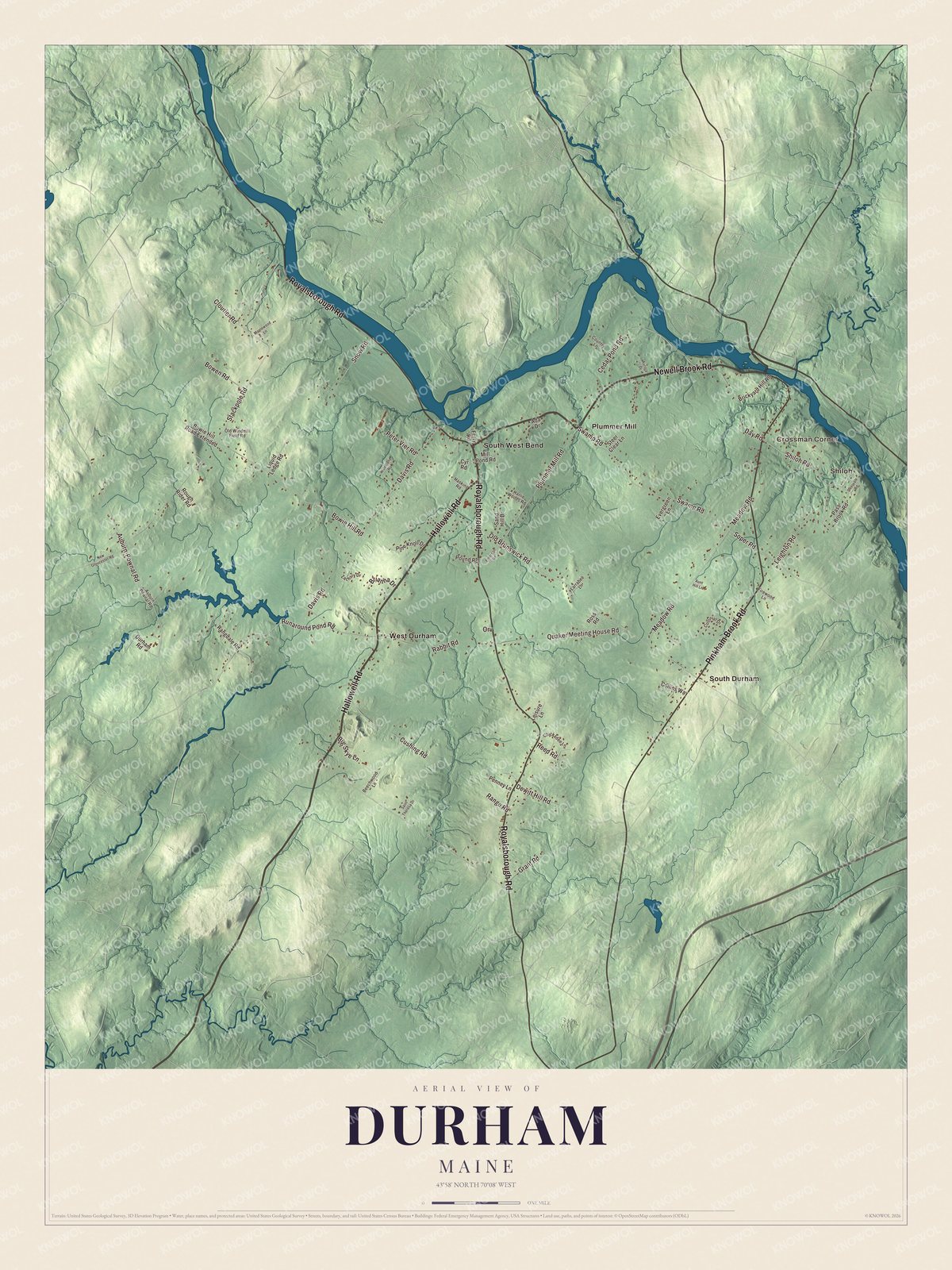
Click to explore a larger preview. The digital watermark does not appear on printed maps.
See it on a wall
The Durham map as a framed print. Swipe for more.


West Durham and Shiloh
The West Durham Methodist Church, on Runaround Pond Road just west of Hallowell Road, grew out of an early Methodist revival meeting held on the site, and its congregation was one of the first Methodist congregations in Maine. Its parish once stretched from Litchfield to Freeport. The building, restyled in 1867, joined the National Register in 2003.
Shiloh, on the south bank of the Androscoggin, began in 1897 as the home of a Bible school and religious community built by the preacher Frank Sandford. At its height the complex had 500 rooms. Sandford later faced criminal charges and spent nearly seven years in prison, and after 1920 the community dwindled. Only the chapel was left standing, and since 1998 Shiloh Chapel has been an independent evangelical church serving Durham. Stephen King moved to Durham at eleven and went to Durham Elementary School. The town’s page says he based the fictional Jerusalem’s Lot on Durham, and the chapel’s page says the Marsten House in Salem’s Lot is believed to be partly inspired by Shiloh.
Dr. Edward H. Hill began his medical practice in Durham before moving to Lewiston, where he founded what’s now Central Maine Medical Center. Between Hallowell Road and Royalsborough Road, just north of Rabbit Road, the privately owned Margerison Airport, opened in 1979, has two unpaved runways.
Corners and roads
Royalsborough Road, Hallowell Road, Runaround Pond Road, Pinkham Brook Road, Newell Brook Road and Auburn-Pownal Road are printed on the map. Shiloh, Crossman Corner, Plummer Mill, South Durham, South West Bend and West Durham are printed too, and the smaller roads between them are drawn in as well.
This Durham map makes a fine addition to an office, library or den, and it can help teach children the geography and history of the area. It’s made for everyone who calls Durham home, from Shiloh to South Durham, as it looks today. Zoom in on the preview above to explore the details, then click here to get your copy of the Durham, Maine map.

Sources
- Durham, Maine, Wikipedia
- Bagley-Bliss House, Wikipedia
- Nathaniel Osgood House, Wikipedia
- Union Church (Durham, Maine), Wikipedia
- West Durham Methodist Church, Wikipedia
- Shiloh Temple, Wikipedia
- Stephen King, Wikipedia
- Edward H. Hill, Wikipedia
- National Register of Historic Places listings in Androscoggin County, Maine, Wikipedia