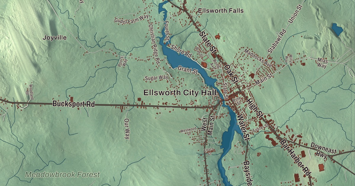
High Street, State Street and Bar Harbor Road are the ones to find first on this map of Ellsworth, Maine, with Ellsworth City Hall up on its hill. Then look out to Ellsworth Falls, North Ellsworth and Joyville, and to Green Lake and Branch Lake. Click here to purchase a print of this map for your wall.
Ellsworth is a city in Hancock County, with 8,399 people at the 2020 census.
KNOWOL made this map in 2026 from public survey data and gave it the look of an old atlas. The Census Bureau measures the city at 93.92 square miles, 14.64 of them water, and its files give the streets and the city line. United States Geological Survey elevation data shades the ground, which has a listed elevation of 302 feet.
Union River Settlement
The Passamaquoddy and Penobscot lived in this country first. Ellsworth’s modern story begins around 1763, when Benjamin Milliken and Benjamin Joy led a party of settlers to the Union River to build dams and sawmills and put its timber and water power to work. The river got its name from the old land grants, three townships on each side of it. In 1773 the first schooner was built here, the Susan and Abigail, named for the daughters of Milliken and Joy, and it carried shingles and staves to the West Indies. Shipyards along the Union River kept building schooners until about the turn of the 20th century.
Known for a time as the Union River Settlement, the town asked in 1798 to be incorporated as Sumner. That name was taken, so in 1800 it became Ellsworth, for Oliver Ellsworth of Connecticut, a delegate to the Constitutional Convention and later the third Chief Justice of the Supreme Court, who had proposed calling the new government “the United States.” Ellsworth became the county seat in the late 1830s, and its 1834 town hall and 1838 courthouse still stand on Court Street across the river, now home to the Courthouse Gallery. By 1859 the town had nine sawmills, eight brickyards, thirteen shipbuilders and much more, and historian Albert Davis counted 653 soldiers sent to the Civil War at a time when the town had only 847 male voters. It became a city in 1869.
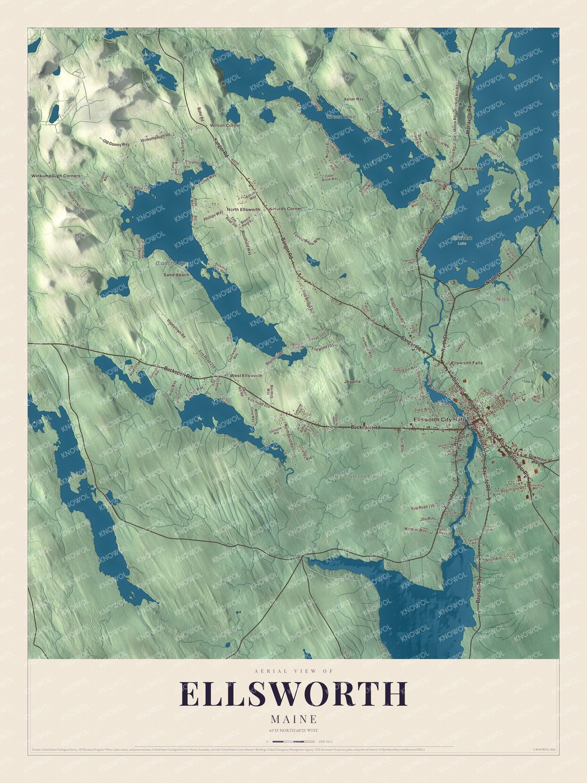
Click to explore a larger preview. The digital watermark does not appear on printed maps.
See it on a wall
The Ellsworth map as a framed print. Swipe for more.


Rebuilt in brick
In 1907 a dam went up on the Union River just above downtown, forming Leonard Lake, named for the project’s engineer, James Leonard. Its power plant, by its page’s account, was one of the first peaking power plants in Maine, and the dam was described in 1928 as “the highest power dam in New England.” After a fire swept the business district east of the river in 1933, Ellsworth rebuilt in brick, mostly in the Art Deco style. The Grand on Main Street opened in 1938 as a movie theater with a stepped glass tower and marquee, and since 1975 it has been a nonprofit stage for theater, music and film. Ellsworth City Hall went up in 1934 and 1935 on a hill overlooking downtown, a Georgian Revival design by Philadelphia architect Edmund Gilchrist, built with the help of federal and state relief crews.
Across State Street from City Hall, the Ellsworth Public Library fills a Federal house of 1817, given to the city as a library in 1897 by George Nixon Black. The Black family’s own home, Woodlawn, a brick mansion begun in 1824 for land agent John Black and finished three years later, is now a museum on 180 acres of fields and trails. At 406 State Street, the Agassiz Bedrock Outcrop shows grooves cut by glacial ice. The Harvard geologist Louis Agassiz studied it in 1864 and wrote of the “splendid polished surfaces” at Ellsworth Falls in his 1867 paper arguing that ice sheets had once covered North America.
Birds, lakes and rails
Cordelia Stanwood was born in Ellsworth and spent 50 years studying the birds around her family homestead on the road to Bar Harbor. She was self-taught, published her studies and photographs, and is reported to be the first female professional bird photographer; she also lobbied the Maine Legislature to ban imported feathers for women’s hats. Her homestead, badly damaged by a fire in 2014, is the heart of Birdsacre Sanctuary, now about 200 acres of trails. Out on Green Lake there’s a national fish hatchery that’s part of the Atlantic salmon restoration program, and the lake has long been known for its big lake trout. The Downeast Scenic Railroad runs heritage trains on the old Calais Branch. It made its first run in 2010, and its first 4 miles of track, out to Ellsworth Falls, are complete.
Around Ellsworth
High Street is the direct route to Bar Harbor and Acadia National Park, and since the 1960s and 1970s it has grown into what the city page calls the largest shopping district in Hancock County. High Street, State Street and Bar Harbor Road are printed on the map, and so are Bucksport Road, Oak Street and North Street. Ellsworth City Hall and Wilson Corner are printed too, along with Ellsworth Falls, Hurds Corner, Joyville, Lakewood and North Ellsworth, and Green Lake, Branch Lake and Meadowbrook Forest are labeled on the map. The rest of the city’s streets are drawn in as well.
This Ellsworth map makes a fine addition to an office, library or den, and it can help teach children the geography and history of the area. It’s made for everyone who calls Ellsworth home, from Ellsworth Falls to Branch Lake, as it looks today. Zoom in on the preview above to explore the details, then click here to get your copy of the Ellsworth, Maine map.

Sources
- Ellsworth, Maine, Wikipedia
- Old Hancock County Buildings, Wikipedia
- Ellsworth Power House and Dam, Wikipedia
- The Grand (Ellsworth, Maine), Wikipedia
- Ellsworth City Hall, Wikipedia
- Ellsworth Public Library, Wikipedia
- Woodlawn Museum, Wikipedia
- Agassiz Bedrock Outcrop, Wikipedia
- Cordelia Stanwood, Wikipedia
- Birdsacre Sanctuary, Wikipedia
- Green Lake (Maine), Wikipedia
- Downeast Scenic Railroad, Wikipedia