
A river town set off from Wethersfield in 1693, strung along a broad, tree-lined Main Street, where the oldest ferry in the country still crosses to Rocky Hill and Roaring Brook once ran powder, cotton, paper and anchor mills.
Then and now
The same town 157 years apart. Click either map to look closer.
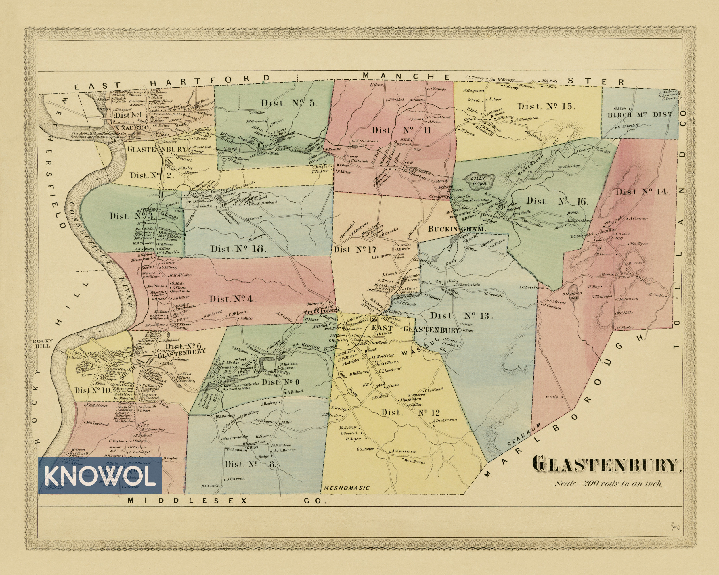
The landowners map
By Baker & Tilden
Glastenbury under its old spelling, with every plot labeled with its owner's name, 18 school districts from Naubuc to Birch Mountain, and landmarks like Eagle Mills, the Glastonbury Knitting Company, Strickland Foundry, Diamond Lake and Bucks Corner.4
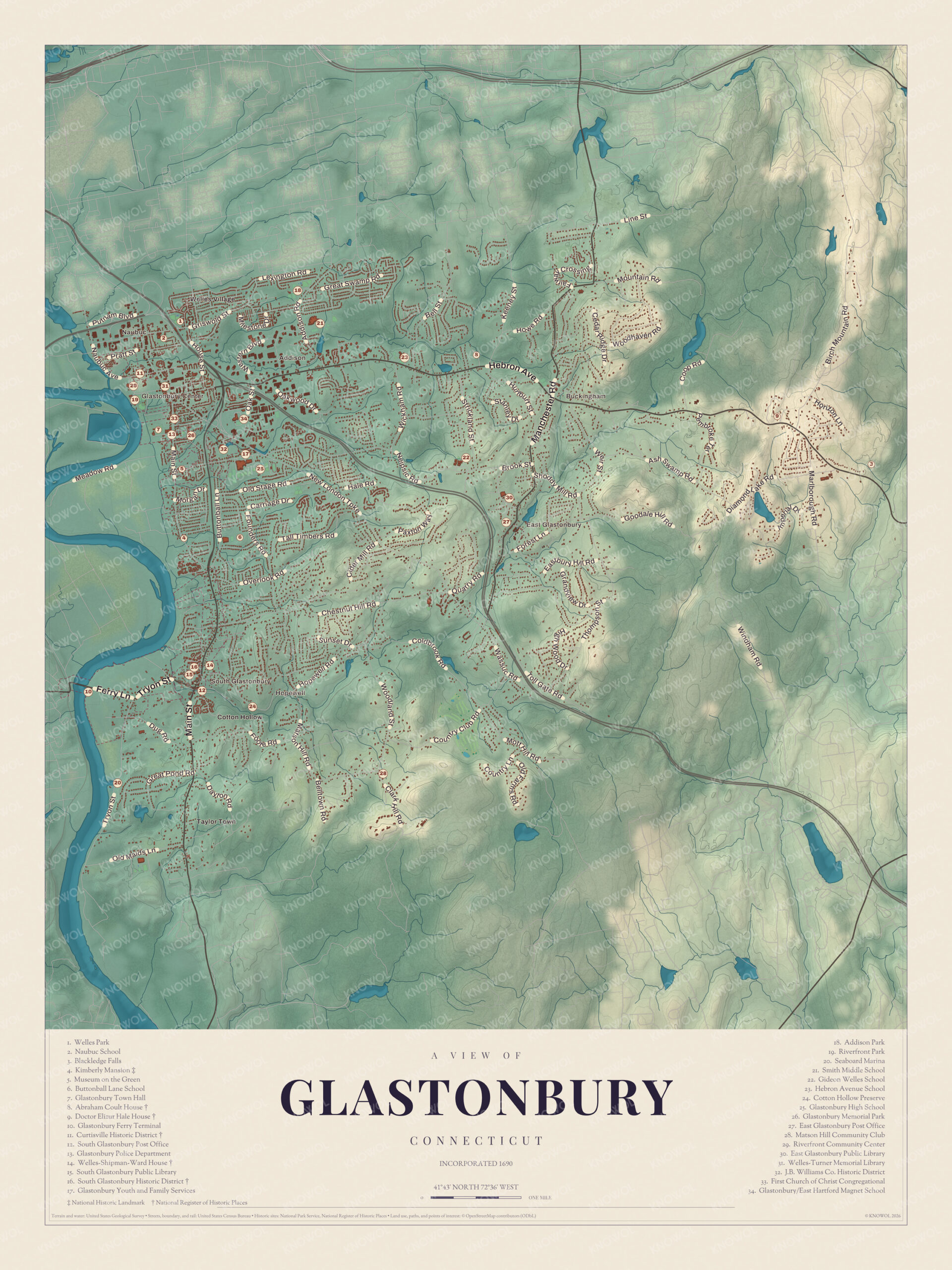
Glastonbury today
By KNOWOL
Shaded hills from the river meadows up into the foothills around Belltown Hill, every street, Glastonbury, South Glastonbury, East Glastonbury and Cotton Hollow by name, and a guide of 34 numbered landmarks with the National Register sites marked.5
The story of Glastonbury
Training day at Welles Tavern
Before the railroads, the stage between Hartford and New London ran down Glastonbury's Main Street, and its first stop out of Hartford was Welles Tavern, just north of Welles Corner. A long blast on the horn warned the regulars inside, four horses pulled up a coach that often held fifteen or twenty passengers, and everyone climbed out for rum or the toddy the tavern was famous for. Twice a year, in May and October, the militia formed in front of the same tavern to train, the great gala day of the year. One captain, more used to oxen, shouted Gee and Haw at his men and then, Whoa, Halt! I mean. The town's own Naubuc Guard, in dark blue with silver lace, fired as one man.67
The powder mill at Cotton Hollow
Roaring Brook nearly cuts Glastonbury in two on its way to the river at South Glastonbury, and for two centuries it turned wheels. In the deep valley of Cotton Hollow, gunpowder was made until August 23, 1777, when the mill blew up and killed George Stocking and his three sons, George, Hezekiah and Nathaniel. The next year his widow, Eunice, asked the General Assembly to take the four men off the town tax list, and it did. Cotton mills, one of brick and one of stone, later filled the hollow. By 1884 the same brook also ran paper mills, Pratt and Post's anchor forge, Hollister and Glazier's woolen mill and a twine factory. The ruins of the cotton mill built in 1814 still stand in Cotton Hollow Preserve.89101
The Street
Glastonbury began as the east-side farms of Wethersfield. Each early lot was a long strip running from the river meadows back three miles into the woods, and the country road across them, laid out six rods wide, became Main Street. In 1690 twenty-four landowners asked the General Court to make them a town, and when their meetinghouse was finished in 1693, Glastonbury became the first town in the colony made by dividing another. Before the Revolution the town had trees planted along the street. "What a street it is," the town's historian wrote in 1886, "the pride of every resident and the admiration of every visitor!" The Glastonbury Historic District along Main Street still holds 23 houses built before 1800.1121213
Through the years
24 moments from 1636 to today.
- 1636Thirty families settle Pyaug, a tract of Wethersfield on the east bank of the river.1
- 1655The ferry to what's now Rocky Hill begins, before either town exists.1
- 1675About this year John Hollister, Jr. builds the house on Tryon Street that's now the town's oldest.14
- 1690On May 8 the General Court grants 24 east-side landowners the right to be a town of their own.11
- 1692The General Court names the new town Glassenbury, after Glastonbury in England.11
- 1693The first meetinghouse is finished on the Green, and Glastonbury becomes the first town in the colony made by dividing another.2
- 1701The selectmen hire Robert Poog as the town's schoolmaster.11
- 1734The first meetinghouse burns on the night of December 9.11
- 1755Thomas Welles builds a Georgian house in South Glastonbury as a wedding gift for his son John.15
- 1775News of Lexington and Concord is read from the pulpits on a Sunday, and the militia spends the day casting bullets.11
- 1777On August 23 the powder mill at Cotton Hollow blows up, killing George Stocking and his three sons.8
- 1783Captain Samuel Welles builds the house where Gideon Welles will be born in 1802.16
- 1785Glassenbury becomes Glastenbury.1
- 1794A Glastonbury man writes in his diary of a ship launching watched by at least 3,000 people.17
- 1803The town organizes its first library.1
- 1828The Methodists build a brick church in South Glastonbury, the only church in town with no spire or bell.18
- 1840The first town meeting is held in the new town hall on the Green on October 5.11
- 1849James B. Williams moves his soap business to Glastonbury.19
- 1854In the great flood, a house on the Island stands alone above a lake of river water.20
- 1866J. H. Hale plants his first acre of orchard, on the way to becoming the Peach King.1
- 1869Baker & Tilden publish their landowners map of Glastenbury.4
- 1870The town votes to spell its name Glastonbury, to match the town in England.1
- 1873Abby and Julia Smith refuse to pay their taxes without a vote, and the town seizes their cows.21
- 1948The Saglio brothers form Arbor Acres, whose broiler wins the title Chicken of Tomorrow.1
Places to see
The numbers match the landmark guide printed on the 2026 map.
- 4Kimberly MansionMain Street. Home of the Smith sisters.
- 5Museum on the GreenGlastonbury Center. In the town hall of 1840.Visit their website
- 7Glastonbury Town HallGlastonbury Center. Seat of town government today.
- 10Glastonbury Ferry TerminalWest of South Glastonbury. Crossing to Rocky Hill since 1655.
- 11Curtisville Historic DistrictNaubuc Avenue and Pratt Street. Mill workers' houses on Salmon Brook.
- 14Welles-Shipman-Ward HouseMain Street, South Glastonbury. A wedding gift of 1755.Visit their website
- 15South Glastonbury Public LibrarySouth Glastonbury. In the brick Methodist church of 1828.
- 16South Glastonbury Historic DistrictSouth Glastonbury. The town's first village.
- 24Cotton Hollow PreserveEast of South Glastonbury. Mill ruins on Roaring Brook.
- 32J.B. Williams Co. Historic DistrictSoutheast of the center. The soap works, now homes.
On the National Register
All 11 places in Glastonbury on the National Register of Historic Places that still stand today, oldest first, and why each one matters.3
-
Glastonbury-Rocky Hill Ferry Historic District
Both ferry landings and the river between them, with the old farm meadows and the landing village on Tryon Street, where the Thomas Treat house of about 1700 is the oldest. The ferry has joined the two shores since 1655. Shared with Rocky Hill.22
-
John Hollister House
The town's oldest surviving colonial building, built by John Hollister, Jr., whose father is credited with Glastonbury's first house. It began as a two-room house around a central chimney.14
-
Glastonbury Historic District
Main Street from Hubbard Street to Talcott Road, first a Native trail along the river. It holds the small green, the 1840 town hall and the early cemetery, and 23 houses built before 1800, one of the largest groups in the state.13
-
Kimberly Mansion
National Historic Landmark
Home of Abby and Julia Smith, who refused to pay taxes without a vote. The town seized and sold their cows, the sisters bought them back and won in court, and the case drew national attention to women's suffrage.21
-
Abraham Coult House
A colonial house enlarged several times, showing how building methods changed. The water authority sold it in 1972 for $500 on condition it be moved, and it was moved about 1,500 feet and restored.23
-
South Glastonbury Historic District
The town's first village, grown up around the ferry road and the mills on Roaring Brook. It takes in the library in the Methodist church of 1828, St. Augustine's Church of about 1878 and the Tryon House of about 1731.24
-
Welles-Shipman-Ward House
Built as a wedding gift for John Welles from his father, Thomas, it is a well-preserved Georgian house with the largest period fireplace in Connecticut. The Historical Society of Glastonbury has kept it since 1963.15
-
Dr. Elizur Hale House
A well-preserved late Georgian house that the Hale family lived in for 100 years. Dr. Elizur Hale, a Yale graduate of 1742, practiced medicine in his native town.25
-
Gideon Welles House
Built by Captain Samuel Welles for his son and called the grandest house in Glastonbury. Gideon Welles, Lincoln's Secretary of the Navy, was born here in 1802. Saved from demolition in 1935 by the group that became the Glastonbury Historical Society, it was moved a short distance in 1936.16
-
Curtisville Historic District
Mill workers' houses and farms along Salmon Brook, where Oswin Welles made wooden wares in the 1840s and the Curtis brothers ran a silver plating works. During the Civil War the same mill made rifles and pistols.26
-
J. B. Williams Co. Historic District
The soap works James B. Williams moved here in 1849, with the family's houses. At its peak in the 1920s it employed about 300 people, the town's largest employer, and its old factory buildings are homes now.19
In their words
“And what a street it is, the pride of every resident and the admiration of every visitor!”
The Memorial History of Hartford County, 1886, on Main Street12
“It was the great gala day of the year for every one in town.”
The Connecticut Quarterly, 1896, on militia training day7
“We have the satisfaction of knowing that territorially we sprang from, and are connected with, the oldest town in this Commonwealth”
The Memorial History of Hartford County, 188611
Nearby towns
Sources
- Glastonbury, Connecticut, Wikipedia
- The Memorial History of Hartford County, Connecticut, 1633-1884 (1886), on the setting off of Glastonbury, Internet Archive
- National Register of Historic Places listings in Hartford County, Connecticut, Wikipedia
- Historic landowners map of Glastonbury, CT from 1869, restored by KNOWOL
- Map of Glastonbury, Connecticut in 2026, KNOWOL (USGS elevation, Census Bureau roads)
- Glastonbury Sketches by Henry Storrs Goslee, The Connecticut Quarterly (1896), on Welles Tavern, Internet Archive
- Glastonbury Sketches by Henry Storrs Goslee, The Connecticut Quarterly (1896), on training days, Internet Archive
- The Memorial History of Hartford County, Connecticut, 1633-1884 (1886), on Roaring Brook and Cotton Hollow, Internet Archive
- The public records of the State of Connecticut (1894), on the memorial of Eunice Stocking, Internet Archive
- The historical, statistical and industrial review of the state of Connecticut (1884), on Glastonbury, Internet Archive
- The Memorial History of Hartford County, Connecticut, 1633-1884 (1886), chapter on Glastonbury by William S. Goslee, Internet Archive
- The Memorial History of Hartford County, Connecticut, 1633-1884 (1886), on Main Street, Internet Archive
- Glastonbury Historic District, Wikipedia
- John Hollister House, Wikipedia
- Welles-Shipman-Ward House, Wikipedia
- Gideon Welles House, Wikipedia
- History of Connecticut in monographic form (1925), on shipbuilding, Internet Archive
- The Memorial History of Hartford County, Connecticut, 1633-1884 (1886), on the churches of Glastonbury, Internet Archive
- J. B. Williams Co. Historic District, Wikipedia
- The History of Ancient Wethersfield, Connecticut, volume II (1904), on the Island, Internet Archive
- Kimberly Mansion, Wikipedia
- Glastonbury-Rocky Hill Ferry Historic District, Wikipedia
- Abraham Coult House, Wikipedia
- South Glastonbury Historic District, Wikipedia
- Dr. Elizur Hale House, Wikipedia
- Curtisville Historic District, Wikipedia