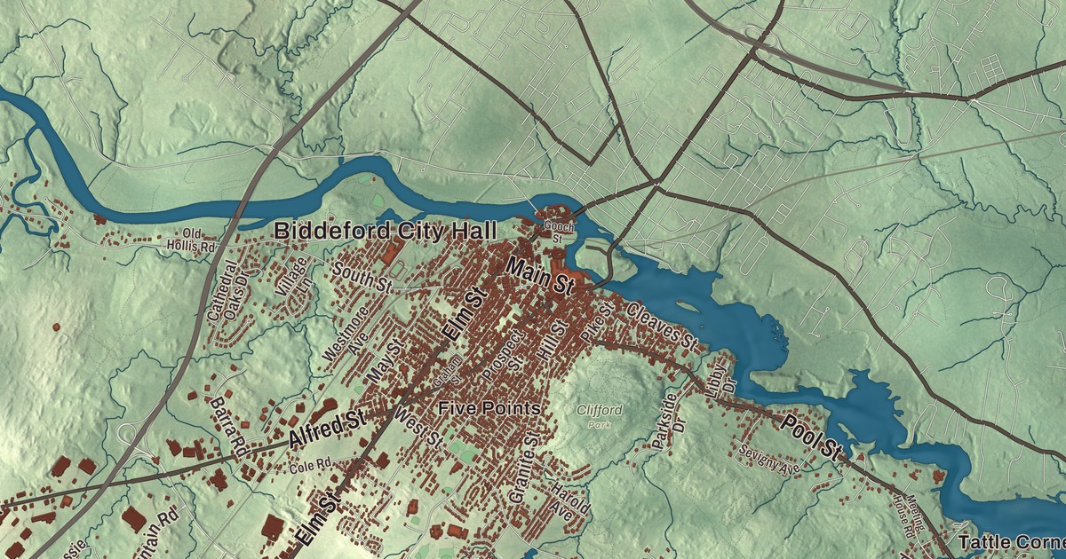
From Biddeford City Hall on Main Street out to Biddeford Pool and Hills Beach, this map of Biddeford carries the names you know. It prints Elm Street, Alfred Street, Pool Street, Bridge Road and Mile Stretch Road, and the neighborhoods of Airport Village, Five Points, Fort Hill and Guinea Corner. Etherington Pond, Great Pond and the Atlantic Ocean are printed as well. Click here to purchase a print of this map for your wall.
Biddeford is a city in York County, the county’s main commercial center, and it had 22,552 people at the 2020 census.
KNOWOL made this map in 2026 from public survey data and gave it the look of an old atlas. Its relief comes from United States Geological Survey elevation data, and its streets and city line come from the Census Bureau. The city lies beside Saco Bay, with almost 15 miles of frontage on the Saco River and a coastline on the Atlantic.
Winter Harbor, Saco and Biddeford
The story here starts on the shore. In the winter of 1616 and 1617 the physician Richard Vines stayed at the place he called Winter Harbor, now Biddeford Pool, as part of Sir Ferdinando Gorges’s efforts to colonize Maine. The town page notes that this came about four years before the Mayflower reached Plymouth. In 1653 the Massachusetts General Court incorporated a town on both sides of the river as Saco, and that same year Roger Spencer won the right to build its first sawmill. Lumber and fish became the chief exports. In 1718 the town was reorganized as Biddeford, named for Bideford in Devon, England, where some of its settlers had come from. The land northeast of the river was set off in 1762 as Pepperellborough, renamed Saco in 1805, and the first bridge across to it was built in 1767.
The Saco River divides into two falls here that drop 40 feet, and they gave water power to mills. Boots and shoes were made here, along with granite from the quarries and brick from the brickyards, and big textile mills rose along the riverbanks, among them the Laconia Company in 1845 and the Pepperell Company in 1850. Biddeford became a city in 1855. The mills drew Irish, Albanian and French-Canadian families, and at one time they employed as many as 12,000 people. The last textile company closed in 2009, and the mill buildings are being turned into housing and new businesses. The Biddeford-Saco Mills Historic District covers 38 acres on both banks of the river.
Some of the oldest buildings of their kind in Maine are here. The First Parish Meetinghouse on Old Pool Road was built in 1758 by the master builder Nathaniel Perkins, and its page calls it the oldest public building in the city. Its page links it to James Sullivan, who rose to prominence as a lawyer in Biddeford and later became governor of Massachusetts. The John Tarr House at the end of Ferry Lane, facing the Saco, was built about 1730, and its page counts it among the oldest houses in the state. Since 1982 the city has celebrated its French and French Canadian heritage at La Kermesse, a festival with live music and fireworks and a green frog for its mascot.
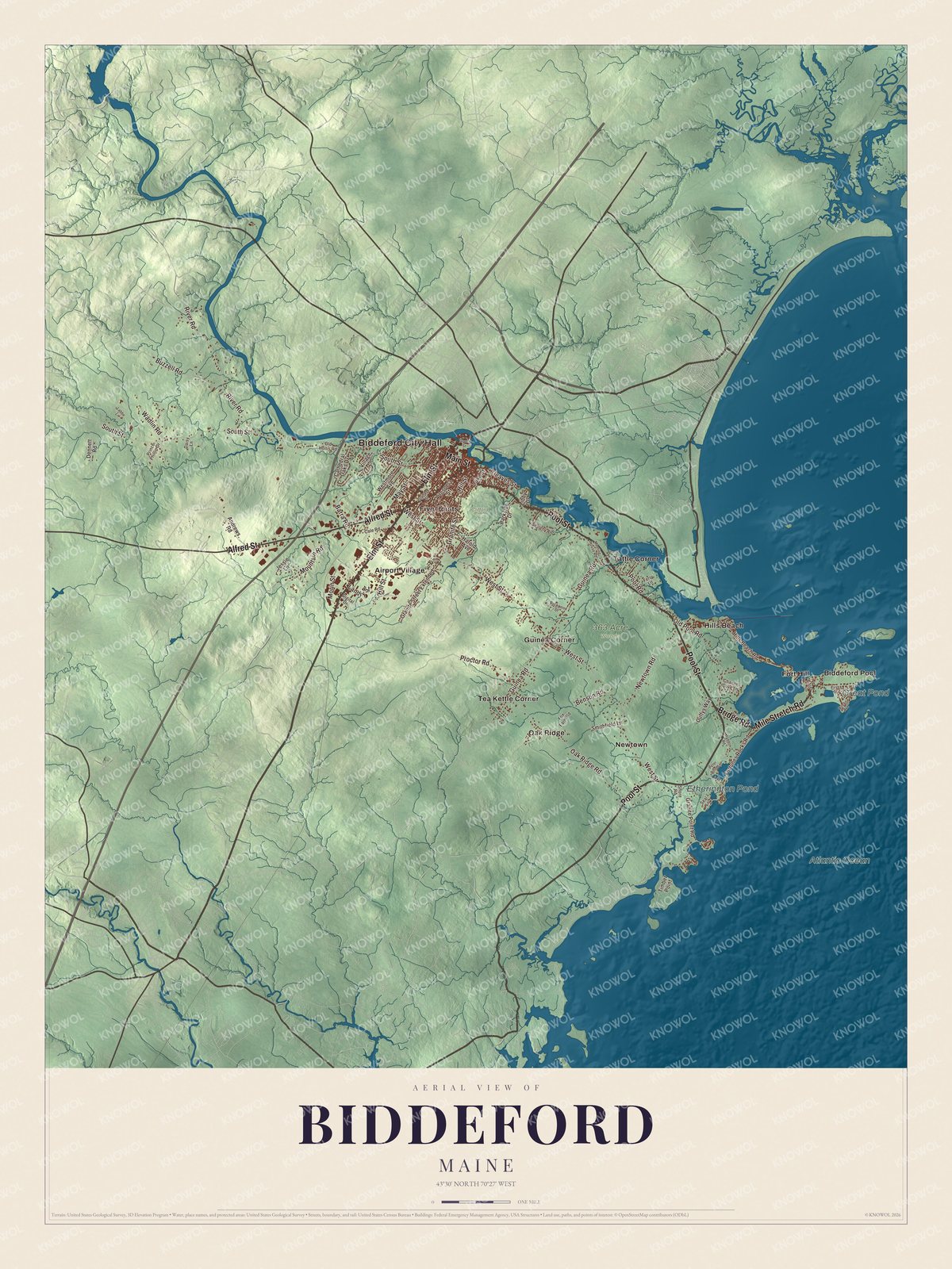
Click to explore a larger preview. The digital watermark does not appear on printed maps.
See it on a wall
The Biddeford map as a framed print. Swipe for more.


From City Hall to the Pool
Biddeford City Hall is printed on the map. It stands at 205 Main Street, and after a fire destroyed the old city building at the end of 1894, the Maine architect John Calvin Stevens designed the new one, with a Colonial Revival opera house inside. That theater reopened on January 20, 1896, and became a stop on the vaudeville circuit. Now called City Theater, it seats nearly 500 people and puts on plays, concerts and comedy all year.
Main Street is printed too. The Biddeford Main Street Historic District runs along Main and Water streets and parts of Elm, Alfred and other side streets, and its oldest building, the Thatcher Hotel, went up in 1846. Elm Street is printed as well. At 178 Elm Street stands Saint Joseph’s Church, built for French-Canadian Catholic families who came from Quebec and dedicated in 1883. Its page calls it the tallest building in Maine.
Bridge Road is printed on the map. At number 56, the Richard Vines Monument was listed on the National Register of Historic Places in 2022. Mile Stretch Road is printed as well. The Biddeford Pool page describes it as a sandy strip of beach joining the Pool to the mainland, a notable tombolo. Biddeford Pool and Hills Beach are printed too. The Pool is a big tidal pool, deep enough to navigate at high tide and mostly mudflats at low, with a deep mouth called “The Gut” where most of the boats are moored. The Fletcher’s Neck Lifesaving Station stands at Ocean Avenue and Fourth Street. It opened in 1874 and stayed in service until 1971. About a mile offshore, Wood Island Light, established in 1808, is called Maine’s second-oldest lighthouse on its page. Airport Village, Five Points, Fort Hill and Guinea Corner are printed on the map, along with Pool Street, Etherington Pond and Great Pond.
This Biddeford map makes a handsome addition to an office, library or den, and it can teach children the geography and history of a mill city on the sea. It’s made for anyone who calls Biddeford home, from Five Points to Biddeford Pool, as it looks today. Zoom in on the preview above to explore the details, then click here to get your copy of the Biddeford, Maine map.

Sources
- Biddeford, Maine, Wikipedia
- Biddeford-Saco Mills Historic District, Wikipedia
- First Parish Meetinghouse, Wikipedia
- John Tarr House, Wikipedia
- La Kermesse Franco-Americaine Festival, Wikipedia
- City Theater (Biddeford, Maine), Wikipedia
- Biddeford Main Street Historic District, Wikipedia
- Saint Joseph’s Church (Biddeford, Maine), Wikipedia
- National Register of Historic Places listings in York County, Maine, Wikipedia
- Biddeford Pool, Wikipedia
- Fletcher’s Neck Lifesaving Station, Wikipedia
- Wood Island Light, Wikipedia