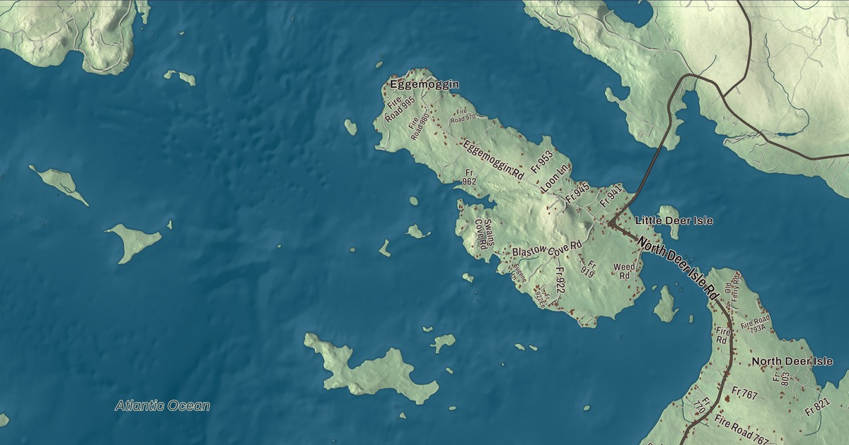
Cross the bridge onto Eggemoggin and Little Deer Isle and this map of Deer Isle, Maine opens up: North Deer Isle Road, South Deer Isle Road, Sunshine Road, Sunset Road, Greenlaw District Road and Pressy Village Road, and the villages of Mountainville, North Deer Isle, Reach, South Deer Isle and Sunset. Holt Pond, Mill Pond, Torrey Pond and Lily Pond are on the sheet too. Click here to purchase a print of this map for your wall.
Deer Isle is a town in Hancock County, with 2,194 people at the 2020 census.
KNOWOL made this map in 2026 from public survey data and gave it the look of an old coastal atlas. The Census Bureau measures the town at 123.67 square miles, and 93.95 of them are water; its files give the roads and the town line. United States Geological Survey elevation data shades the 29.72 square miles of island land.
An island town
Deer Isle dates to 1789, when it was incorporated with the islands of Little Deer Isle, Deer Isle and Isle au Haut, and deer were plentiful on them, hence the name. Isle au Haut became its own town in 1868, and in 1897 the southern third of Deer Isle was incorporated as Stonington. Today the island of Deer Isle holds two towns, Deer Isle and Stonington. Little Deer Isle, about four miles long, is joined to Deer Isle by a causeway, and its northern end is called Eggemoggin. The town’s villages are Deer Isle, Eggemoggin, Little Deer Isle, Mountainville, North Deer Isle, Reach, South Deer Isle, Sunset and Sunshine.
Until 1939 there was no bridge. The Deer Isle Bridge, a suspension bridge over Eggemoggin Reach with a main span of 1,088 feet, was finished that March to designs by David B. Steinman and Holton D. Robinson, and it replaced the old ferry crossing and opened the island to visitors. The road had to sit high enough for yachts to pass under, and the builders met that with steep approaches, and they prefabricated many parts to work between the tides. Wind set the light deck moving even before it was finished, and after storms damaged it in the winter of 1942 to 1943, stronger stays were added. The bridge carries State Route 15 onto Little Deer Isle. Off the northern tip of Little Deer Isle, Pumpkin Island Light, a station established in 1854, guided boats into the northwest end of the Reach until 1933; the island and old station are privately owned now.
Granite, sailors and old houses
In the 19th century the island’s granite quarries thrived, supplying stone for the Boston Museum of Fine Arts, the Smithsonian Institution, the Naval Academy, the Manhattan Bridge and President John F. Kennedy’s tomb at Arlington. The island’s sailors were known for their skill, and full crews for two winning America’s Cup teams, the Defender in 1895 and the Columbia in 1899, were recruited from the island.
The oldest surviving house in town, its page says, is the Peter Powers House on Sunshine Road, built in 1785 for the first settled minister of Deer Isle. Powers was a Harvard-trained minister who had helped found Dartmouth College in 1769, and his house is a rare gambrel-roofed Cape. In the village of Deer Isle, on the neck of land between Mill Pond and Northwest Harbor, Squire Ignatius Haskell built his house in 1793; Haskell came from Newburyport with his father and brother in 1778, and their businesses included a grist mill and a shipyard. The house is the Pilgrim’s Inn today.
On Sunset Road stands the Salome Sellers House, a Cape whose oldest part goes back to the 1770s, now the museum of the Deer Isle-Stonington Historical Society. Salome Sellers was born on Deer Isle in 1800, married Joseph Sellers in 1830, and lived in the house they finished that year until she died in 1909 at 108. Her page calls her the last known, verified person born in the 18th century. South of the village of Sunset, the Shingle style house called Felsted was built in 1897 as a summer home for the landscape architect Frederick Law Olmsted, and it was his summer home for one year.
Haystack and the writers
Haystack Mountain School of Crafts was founded in 1950 near Haystack Mountain in Montville and moved to Deer Isle in 1961. Its campus on Stinson’s Neck, 34 buildings designed by the architect Edward Larrabee Barnes to fit their surroundings, won the American Institute of Architects’ Twenty-five Year Award in 1994 and joined the National Register in 2005. Each summer it runs workshops in blacksmithing, clay, fibers, glass, graphics, metals and wood. John Steinbeck stopped at Deer Isle in Travels with Charley and wrote that “one doesn’t have to be sensitive to feel the strangeness of Deer Isle.” The children’s author Robert McCloskey, of Blueberries for Sal, spent his summers nearby and died in Deer Isle in 2003, and the musician Dan Fogelberg and his wife Jean made the island their last home.
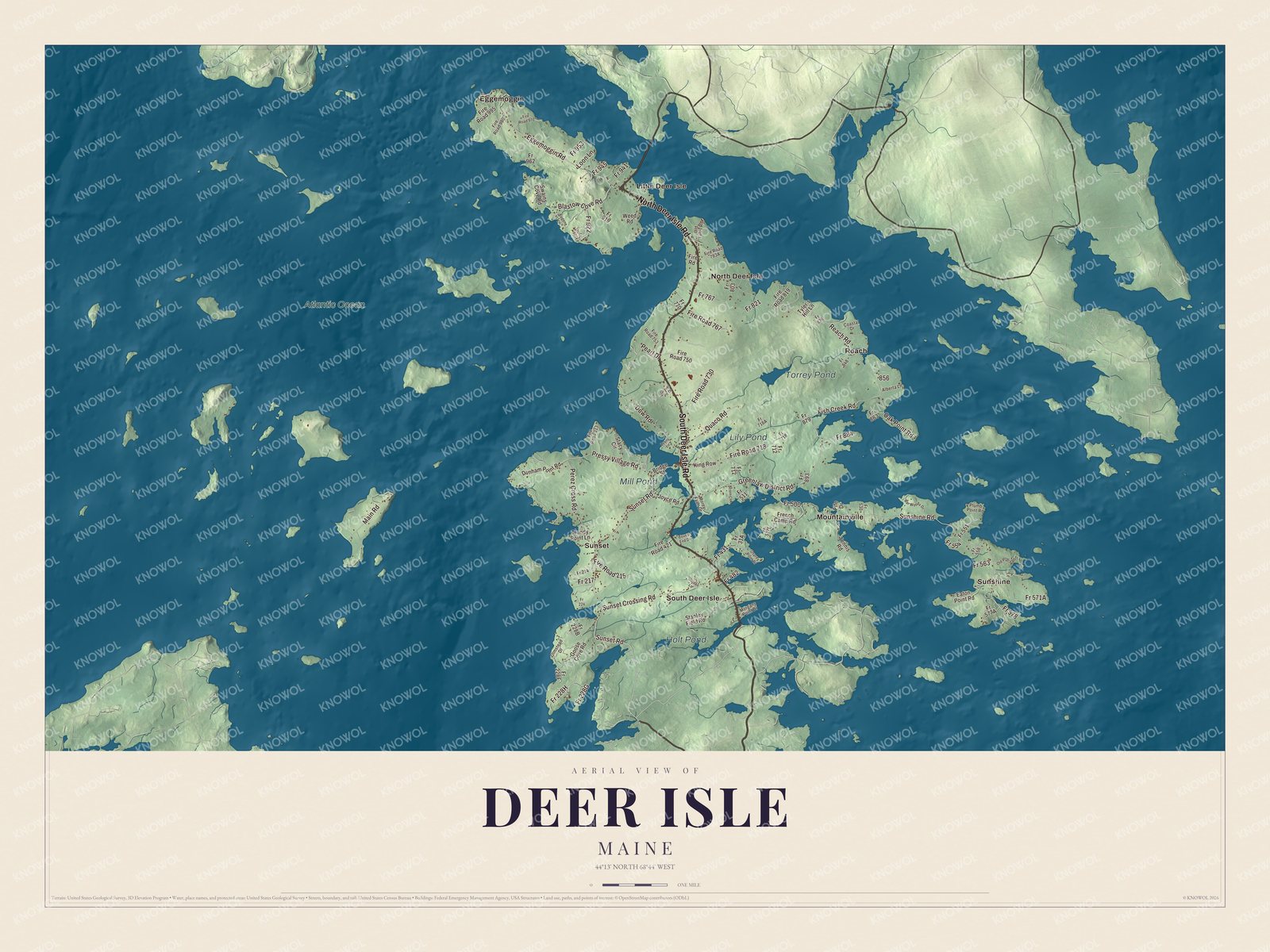
Click to explore a larger preview. The digital watermark does not appear on printed maps.
See it on a wall
The Deer Isle map as a framed print. Swipe for more.


Around the island
Eggemoggin is printed on the map, and so is Little Deer Isle. North Deer Isle Road, South Deer Isle Road, Sunshine Road, Sunset Road, Greenlaw District Road and Pressy Village Road are printed too. Mountainville, North Deer Isle, Reach, South Deer Isle and Sunset are printed across the island, and Holt Pond, Mill Pond, Torrey Pond and Lily Pond are labeled on the map.
This Deer Isle map makes a fine addition to an office, library or den, and it can help teach children the geography and history of the area. It’s made for everyone who calls Deer Isle home, from Eggemoggin to the village of Sunset, as it looks today. Zoom in on the preview above to explore the details, then click here to get your copy of the Deer Isle, Maine map.

Sources
- Deer Isle, Maine, Wikipedia
- Little Deer Isle, Maine, Wikipedia
- Deer Isle Bridge, Wikipedia
- Pumpkin Island Light, Wikipedia
- Stonington, Maine, Wikipedia
- Peter Powers House, Wikipedia
- Squire Ignatius Haskell House, Wikipedia
- Salome Sellers House, Wikipedia
- Salome Sellers, Wikipedia
- Frederick Law Olmsted Summer Home, Wikipedia
- Haystack Mountain School of Crafts, Wikipedia
- Robert McCloskey, Wikipedia