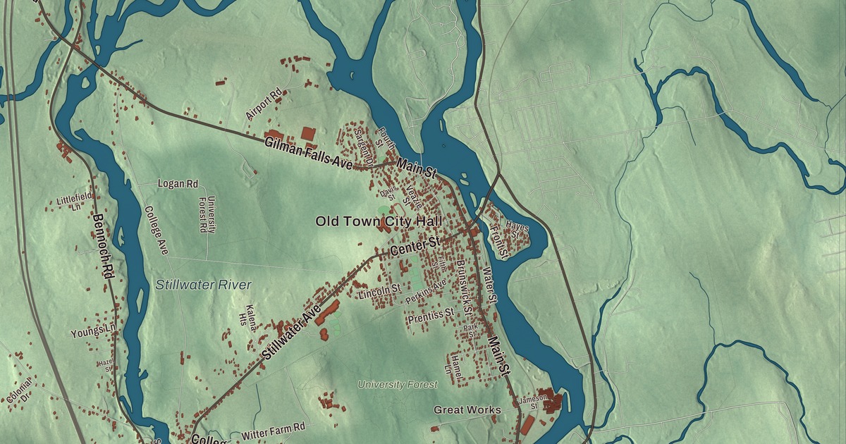
Main Street and Stillwater Avenue cross this map of Old Town, the Penobscot County city whose business district sits on Marsh Island between two rivers. Click here to purchase a print of this map for your wall.
Old Town is a city in Penobscot County.
KNOWOL made this map in 2026 from public survey records, United States Geological Survey elevation data and Census Bureau files. Its atlas layout brings together Old Town’s streets, buildings, rivers, lakes and terrain, the city boundary and the pattern of buildings.
Where the ledges spread out
The Abenaki called this place Pannawambskek, “where the ledges spread out,” for the rapids and drops in the river bed. French Jesuits set up a mission here in the 1680s, and English settlers arrived in 1774. The name comes from “Indian Old Town,” the English name for the largest Penobscot village, on the island now called Indian Island. The island lies within the city limits and is the historic and present home of the Penobscot Nation. Over time the Penobscot village stopped being called Old Town, and the name moved across the river to the newer American settlement.
Old Town was set off from Orono and incorporated on March 16, 1840. Its business district sits on Marsh Island, between the Penobscot River on the east and the Stillwater River on the west. On Indian Island, St. Anne’s Church stands on a mission site whose history reaches back to the late 1600s, one of the oldest Roman Catholic establishments in New England. The present church was built between 1828 and 1830.
Logs and canoes
The rapids along the Penobscot, just upstream from the head of tide at Bangor, made Old Town an ideal place in the 1800s to harness water power for mills cutting the spruce and pine logs floated down the river every year. An 1886 gazetteer said the river here had been called the finest water power in the United States. It described the main boom of the Penobscot Boom Association in the Stillwater, where millions of logs were held and sorted, with 181,000,000 feet rafted in 1855, and lower down the falls at Great Works.
The first canoe of what became Old Town Canoe was built in 1898 behind the Gray hardware store. In 1901 Herbert and George Gray and George Richardson bought the factory on Middle Street, and Old Town went on to become the largest and best known American canoe maker. The company has been based in the city for more than 100 years and still makes canoes and kayaks.
St. James Episcopal Church, at Center and Main streets, was designed by English architect Henry Vaughan and built in 1892 on the stone foundation of the parish’s 1852 church. It’s one of Old Town’s few 19th-century landmarks.
Old Town people
Louis Sockalexis was born on the Penobscot Indian Island Reservation in 1871 and played outfield for the Cleveland Spiders from 1897 to 1899. He’s often identified as the first person of Native American ancestry to play in the National League and the major leagues. Andrew Sockalexis, born in Old Town in 1892 and raised on the reservation, competed in track and field at the 1912 Summer Olympics. Molly Spotted Elk, born on Indian Island in 1903, became a dancer, actress and writer and starred in The Silent Enemy in 1930.
Entomologist Edith Marion Patch lived from 1913 to 1954 at Braeside, a Cape house at 500 College Avenue at the north end of the University of Maine campus. She headed the university’s agricultural experiment station and did groundbreaking research on aphids. Hirundo Wildlife Refuge began in 1965 when Oliver Larouche started it from his parents’ 3-acre camp. It now covers 2,402 acres along Pushaw and Dead streams, and a site there holds evidence of 4,500 years of occupation.
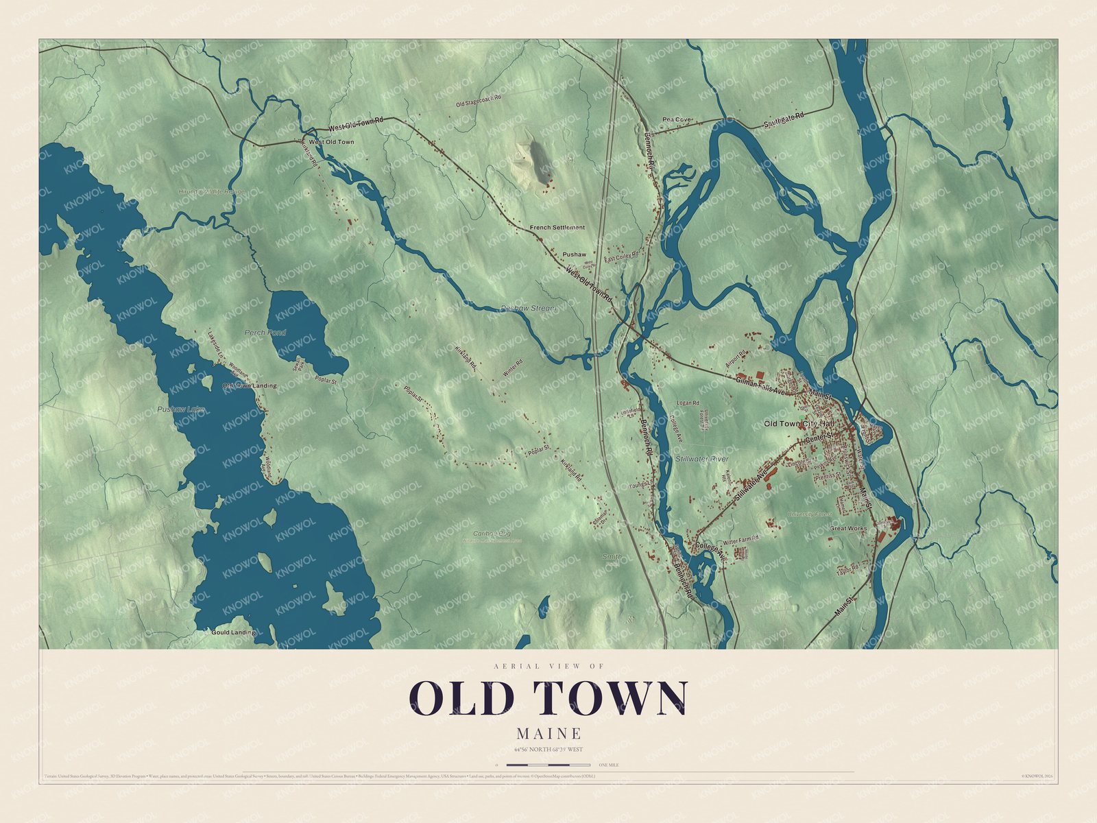
Click to explore a larger preview. The digital watermark does not appear on printed maps.
See it on a wall
The Old Town map as a framed print. Swipe for more.


Explore the Old Town map
Start with Old Town City Hall and Great Works, then follow Main Street, West Old Town Road, Gilman Falls Avenue, Stillwater Avenue, Bennoch Road and Southgate Road across the city. Those names are printed on the artwork. Then look outward toward French Settlement, Gould Landing, Old Town Landing, Pea Cove and Pushaw.
Pushaw Lake, Perch Pond, Pushaw Stream, the Stillwater River, Hirundo Wildlife Refuge and University Forest are labeled too. Sewall Park sits on Perch Pond, which was once called Mud Pond. Trace the Stillwater along the west side of Marsh Island, and compare the busy streets of the island with the woods and wetlands to the west.
For people who call Old Town home, this map shows the city as it looks today. Put it in your office, library, or den, or use it to teach children the geography and history of the area. Zoom in on the preview above to explore the details, then click here to get your copy of the Old Town, Maine map.

Sources
- Old Town, Maine, Wikipedia
- St. Anne's Church and Mission Site, Wikipedia
- Old Town Canoe, Wikipedia
- St. James Episcopal Church (Old Town, Maine), Wikipedia
- Louis Sockalexis, Wikipedia
- Andrew Sockalexis, Wikipedia
- Molly Spotted Elk, Wikipedia
- Edith Marion Patch House, Wikipedia
- Hirundo Wildlife Refuge, Wikipedia
- A Gazetteer of the State of Maine, George J. Varney, 1886 (Internet Archive)