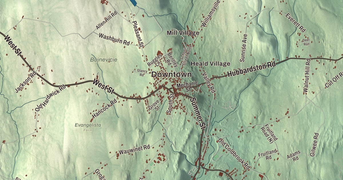
In Barre, summer means a band concert on the common, with Greek Revival fronts looking on across the green. This map prints West Street, Summer Street, Worcester Road, Hubbardston Road, Wheelwright Road and South Barre Road, with the Barre Town Reservoir, the Old Reservoir, Adams Pond, Carter Pond, Allen Hill, Babbitt Hill and Carter Hill. Click here to purchase a print of this map for your wall.
Barre is in Worcester County, drained by the Ware River.
KNOWOL made this map in 2026 from public survey data and dressed it in the style of an old atlas. United States Geological Survey elevation data shades the hills, and the Census Bureau provides the roads and the town line. Barre covers 44.6 square miles, nearly all of it land, and it had 5,530 people at the 2020 census.
From Hutchinson to Barre
The town began as the Northwest District of Rutland. The Town of Barre’s recorded history, in the Secretary of the Commonwealth’s list, dates European settlement to 1720, the year the town page gives too. On June 17, 1774, it was incorporated as a district named Hutchinson, after Thomas Hutchinson, the colonial governor, and the state’s list counts that 1774 date as Barre’s incorporation as a town. Hutchinson’s name didn’t last. On November 7, 1776, the district was renamed for Colonel Isaac Barré, an Irish-born member of Parliament who championed the American cause and is known for coining the name “Sons of Liberty” for the patriots. The town remains part of Worcester County today.
Freedom, and the people who carried it
The town page counts Quock Walker among Barre’s people. Born enslaved in 1753, he sued for his freedom and won in 1781, with the court pointing to the words of the new Massachusetts constitution, “All men are born free and equal,” and his case is credited with helping to end slavery in Massachusetts. His nephew, Kwaku Walker Lewis, was born in Barre in 1798 and named for him. Walker Lewis became an abolitionist, a member of the Underground Railroad, a Freemason and an elder in the Mormon church. Much later, in 1907, the journalist Jacob Riis, author of How the Other Half Lives, moved to a farm in Barre with his second wife, Mary Phillips. He died there in 1914 and lies in Riverside Cemetery under an unmarked granite boulder.
On April 11, 1943, Barre held a civic welcome for Basil Izzi, a local man serving in the Navy Armed Guard who had survived 83 days on a life raft in the Atlantic after his ship, the Zaandam, was torpedoed. In 1988 the Barre Gazette claimed his parade was “still the longest parade on record in the Commonwealth.” Since 2015 the bridge that carries Route 32 over the Ware River near South Barre has carried his name.
The common
The Barre Common was laid out in 1792 and has been the center of the town’s civic life ever since. It’s a 15-acre green shaped roughly like a bent triangle, split into four pieces by the roads. The Barre Congregational Church, built in 1849, faces its northern end, and the Lawrence-Holman-Graziani House of 1836, credited to the architect Elias Carter, shows off a six-column temple front. The Barre Historical Society’s building, from the same year, has a temple front too, and the brick Romanesque Barre Savings Bank of 1894 is the only major building around the common that isn’t wood. The common has held a militia training ground and the town pound, it keeps a 19th-century horse trough and hay scales, and its bandstand, the third one there, still hosts summer concerts. The Barre Common District was listed on the National Register of Historic Places in 1976.
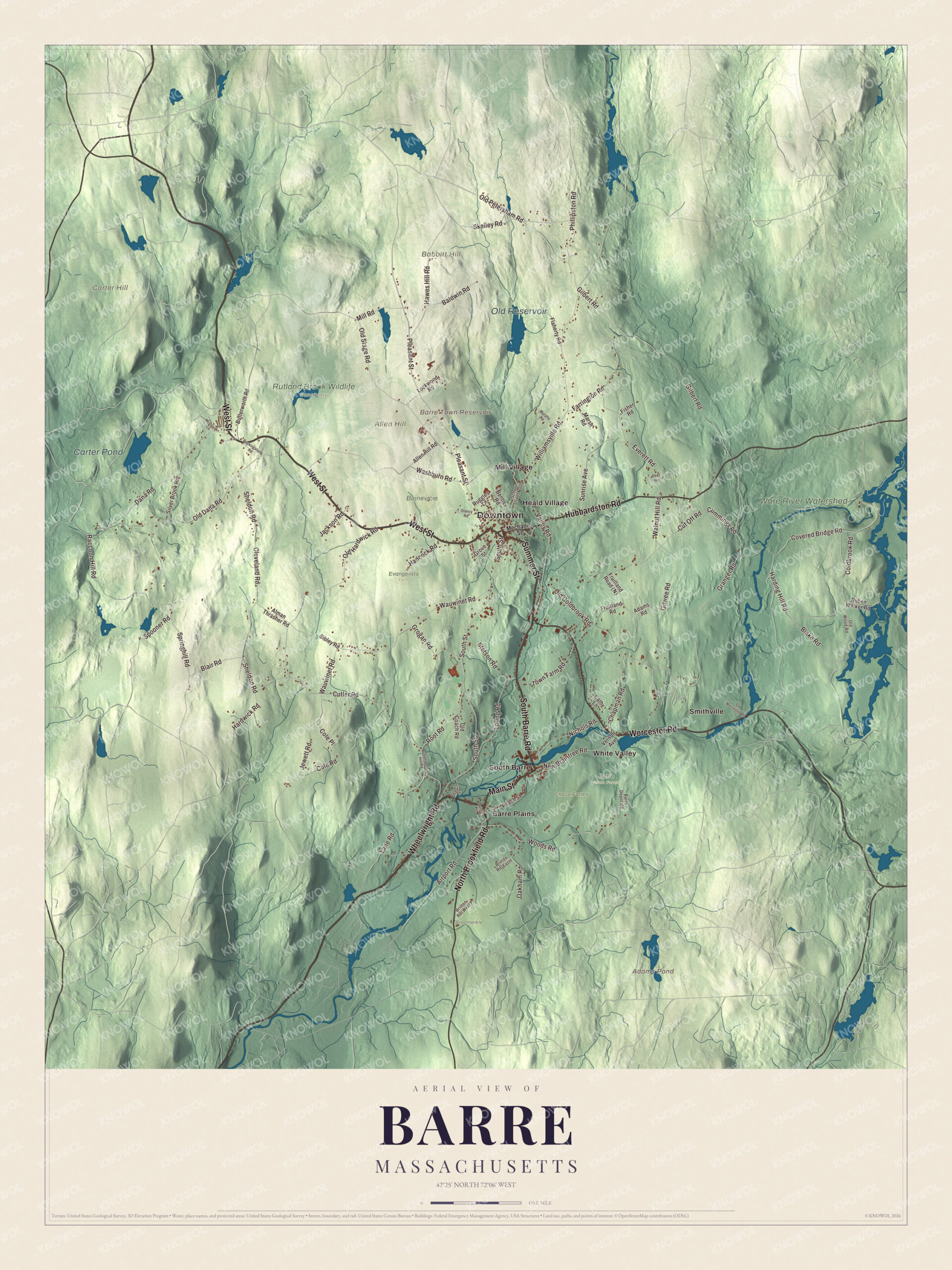
Click to explore a larger preview. The digital watermark does not appear on printed maps.
Names on this map
These names are printed on this map.
Places: Downtown, Allen Hill, Babbitt Hill, Carter Hill, Adams Pond, Barre Town Reservoir, Carter Pond, Old Reservoir, Barre State Forest, Brodmerkle, Bujnevicie, Chase Farms, Evangelista Farm, Rutland Brook Wildlife Sanctuary, Ware River Watershed, Barre Plains, Heald Village, Mill Village, Smithville, South Barre and White Valley.
Streets and roads: West Street, Wheelwright Road, Summer Street, South Barre Road, Worcester Road, Hubbardston Road, North Brookfield Road, Main Street, Pleasant Street, Cutler Road, Blake Road, Woods Road.
More street names, A to Z
Adams Road, Adams Street, Airport Road, Allen Hill Road, Alman Thrasher Road, Austin Street, Baldwin Road, Barre Depot Road, Bentley Road, Blair Road, Butterworth Road, Cathy Lane, Chamberlain Hill Road, Chapman Road, Church Lane, Cleveland Road, Coldbrook Road, Cole Place, Cole Road, Covered Bridge Road, Cummings Road, Cut Off Road, Dana Road, Deer Run, Everett Road, Farrington Road, Fisher Road, Flaherty Road, Fruitland Road, Gilbert Road, Gilwee Road, Glancy Road, Granger Road, Grogan Road, Grove Street, Hancock Road, Harding Hill Road, Hardwick Road, Hawes Hill Road, Jackson Road, Jewett Road, Lane Road, Lockwood Road, Loring Road, Marsh Road, Mechanic Street, Mill Road, Murphy Road, New Braintree Road, Nichols Road, Oakham Road, Old Coach Road, Old Coldbrook Road, Old Dana Road, Old Hardwick Road, Old Petersham Road, Old Stage Road, Old Wood Road, Old Worcester Road, Peach Street, Phillipston Road, Raccoon Hill Road, Rockingstone Road, Root Road, Ruben Walker Road, Ruggles Lane, School Street North, Sheldon Road, Sibley Road, Silver Brook Road, Skelley Road, South Street, Spooner Road, Springhill Road, Stetson Road, Sunrise Avenue, Town Farm Road, Valley Road, Vernon Avenue, Walnut Hill Road, Washburn Road, Wauwinet Road, Williamsville Road.
See it on a wall
The Barre map as a framed print. Swipe for more.


Out from the common
The railroad that carried Barre’s name never reached it. The Boston, Barre and Gardner Railroad was founded in 1849 to reach Barre from Worcester, but when the line opened in 1871 it ran to Gardner instead, and its nearest depot was in Hubbardston, 7 miles away. The Insight Meditation Society, founded in 1975, opened its first retreat center in an old mansion in Barre on February 14, 1976, and the Barre Center for Buddhist Studies started on land next to it in 1990. On the Ware River, the Army Corps of Engineers built the Barre Falls Dam between 1956 and 1958 to hold back floods; there’s no lake behind it, and its flood storage area normally stays empty, and an 18-hole disc golf course winds across the grounds. The Ware River page lists South Barre and Barre Plains among the river’s villages.
Start in Barre Plains, then follow West Street, Wheelwright Road, Summer Street, South Barre Road, Worcester Road and Hubbardston Road out toward Heald Village, Mill Village, Smithville, South Barre and White Valley. The Barre Town Reservoir, the Old Reservoir, Adams Pond, Carter Pond, Allen Hill, Babbitt Hill and Carter Hill are all printed on the map.
This Barre map makes a fine addition to an office, library or den, and it can help teach children the geography and history of the town named for a friend of American liberty. It’s made for people who call Barre home, from Barre Plains to White Valley, and it shows the town as it looks today. Zoom in on the preview above to explore the details, then click here to get your copy of the Barre, Massachusetts map.

Sources
- Barre, Massachusetts, Wikipedia
- Isaac Barré, Wikipedia
- Quock Walker, Wikipedia
- Walker Lewis, Wikipedia
- Jacob Riis, Wikipedia
- Barre Common District, Wikipedia
- Insight Meditation Society, Wikipedia
- Barre Falls Dam, Wikipedia
- Ware River, Wikipedia
- City and Town Incorporation and Settlement Dates, Secretary of the Commonwealth of Massachusetts (archived copy)