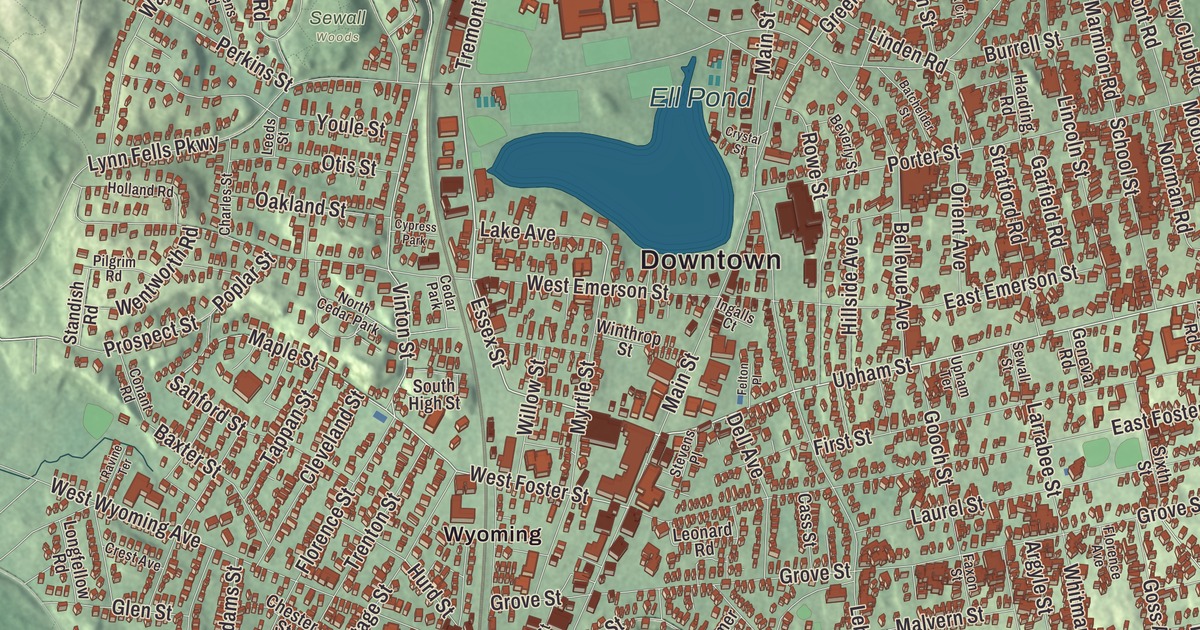
Melrose was first called Ponde Fielde for all its ponds and streams, and Ell Pond still sits just north of the city center. This map prints Broadway, Upham Street, Tremont Street, Essex Street, North Woodcrest Drive and Sweetwater Street, with Ell Pond, Towners Pond, Black Rock, Boojum Rock and Boyntons Hill. Click here to purchase a print of this map for your wall.
Melrose is in Middlesex County.
KNOWOL made this map in 2026 from public survey data and gave it the look of an old atlas. The relief comes from United States Geological Survey elevation data, and the streets and the city line come from the Census Bureau. Melrose is a compact city of 4.8 square miles, about seven miles north of Boston, bordered by Malden, Saugus, Stoneham and Wakefield. Its landmarks include Ell Pond, Swains Pond, Sewall Woods, Mount Hood, Pine Banks Park and the eastern reaches of the Middlesex Fells Reservation. The city had 29,817 people at the 2020 census.
North Malden becomes Melrose
The area was also called Mystic Side, for its valley north of the Mystic River. Richard and Ralph Sprague explored it in 1628, and the city page dates its first settlement to that year. The City of Melrose’s recorded history, in the Secretary of the Commonwealth’s list, dates European settlement to 1629. The land became part of Charlestown in 1633 and part of the new town of Malden in 1649, and as North Malden it remained a lightly populated farming community. The Phineas Upham House on Upham Street, a well-preserved First Period house, dates from the early 1700s; some local historians put it around 1703, while its page suggests Phineas built it a little later for his son Amos.
Then the railroad came. By 1845 the Boston and Maine had three stops here, today’s Wyoming Hill, Melrose/Cedar Park and Melrose Highlands stations, and Boston workers looking for country air moved out and rode the train to work. In 1850 North Malden split from Malden, and Melrose was incorporated as a town in 1850. William Bogle, a Scottish-born neighbor, suggested the name, after the burgh of Melrose in Scotland, whose Eildon hills the new town resembled. In 1853 Melrose annexed the highlands from Stoneham, which set today’s borders, and Melrose Highlands station kept the name Stoneham for years. Melrose was incorporated as a city in 1899, the 33rd in Massachusetts, and Levi S. Gould took office as its first mayor on January 1, 1900. Downtown Melrose joined the National Register of Historic Places in 1982, and the Melrose Public Library, built in 1904 with money from Andrew Carnegie, followed in 1988.
Mount Hood and an ideal place to grow up
Mount Hood was built on donated land in the 1930s under the Works Progress Administration, with a nine-hole golf course, a toboggan run and a ski jump that its page says was credited as the first of its kind in New England. During World War II, soldiers in its Slayton Tower watched the ocean for German U-boats, and from the top you can see the whole Revere Beach area. Today it’s an 18-hole course and park, and a favorite sledding hill in winter. The children’s author Elizabeth George Speare, who won two Newbery Medals, was born in Melrose and remembered it as “an ideal place in which to have grown up, close to fields and woods where we hiked and picnicked, and near to Boston where we frequently had family treats of theaters and concerts.”
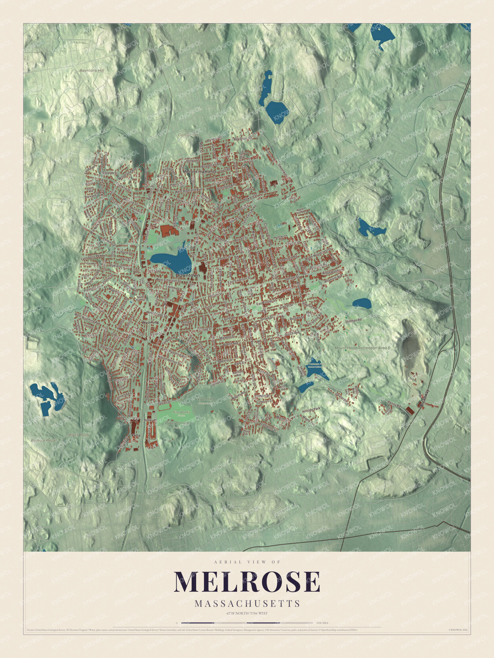
Click to explore a larger preview. The digital watermark does not appear on printed maps.
Names on this map
These names are printed on this map.
Places: Downtown, Black Rock, Boojum Rock, Boyntons Hill, Candle Hill, Ell Pond, Mount Hood Recreation Area & Golf Course, Pine Banks Park, Pine Banks Fields, Towners Pond Conservation Area, Wyoming Cemetery, Sewall Woods, Fells, Melrose Highlands, Wyoming, Walton Park, Hillside Park, Brunswick Park, North Cedar Park, Cedar Park and Cypress Park.
Streets and roads: Broadway, Upham Street, Tremont Street, Essex Street, North Woodcrest Drive, Sweetwater Street, Vinton Street, Orris Street, Maple Street, West Foster Street, Main Street, Lynn Fells Parkway.
More street names, A to Z
Aaron Street, Adams Street, Albert Street, Albion Street, Altamont Avenue, Apple Hill Road, Appleton Street, Ardsmoor Road, Argyle Street, Arlington Street, Ashcroft Road, Ashland Street, Ashmont Street, Auburn Street, Bancroft Road, Banks Place, Batchelder Street, Baxter Street, Bay State Road, Beacon Street, Beech Avenue, Bellevue Avenue, Belmont Street, Beverly Street, Birch Hill Road, Black Rock Road, Boardman Avenue, Boston Rock Road, Botolph Street, Bow Street, Bratley Street, Brazil Street, Burnett Street, Burrell Street, Carlida Road, Cass Street, Cedarwood Lane, Charles Street, Chester Street, Chipman Avenue, Cleveland Street, Clifford Street, Cliff Road, Clinton Road, Cochrane Street, Conant Road, Conrad Road, Converse Lane, Coolidge Road, Corey Street, Cottage Street, Country Club Road, Cranmore Lane, Crescent Avenue, Crest Avenue, Crystal Street, Cumner Avenue, Damon Avenue, Day Street, Dell Avenue, Derby Road, Dexter Road, Dyer Avenue, East Emerson Street, East Foster Street, East Street, East Wyoming Avenue, Echo Street, Elliott Street, Ellis Farm Lane, Elmcrest Circle, Elm Street, Everett Street, Fairfield Avenue, Farwell Avenue, Faxon Street, Felton Place, Ferdinand Street, First Street, Florence Avenue, Florence Street, Forest Street, Frances Street, Franklin Street, Garfield Road, Geneva Road, Glendale Avenue, Glendower Road, Glen Street, Gooch Street, Goodyear Avenue, Goss Avenue, Gould Street, Green Street, Greenwood Street, Grove Street, Hancock Street, Harding Road, Hawes Avenue, Hawley Road, Henry Avenue, Hillcrest Avenue, Hillside Avenue, Holland Road, Howard Street, Howie Street, Hunt Terrace, Hurd Street, Indian Hill Lane, Ingalls Court, Irving Street, Island Hill Avenue, Lake Avenue, Larchmont Road, Larrabee Street, Laurel Street, Leah Street, Lebanon Street, Leeds Street, Leonard Road, Lincoln Street, Linden Road, Linwood Avenue, Longfellow Road, Lovell Road, Lynde Street, Malvern Street, Maple Road, Maple Terrace, Marmion Road, Marvin Road, Meadowview Road, Melrose Street, Meridian Street, Mill Road, Mooreland Road, Morgan Street, Mount Hood Terrace, Mount Vernon Avenue, Mount Vernon Street, Myrtle Street, Mystic Avenue, Naples Road, Natalie Avenue, Nordic Way, Norman Road, North Avenue, North Mountain Avenue, Nowell Road, Oakland Street, Oak Street, Old Brook Circle, Orchard Lane, Orient Avenue, Otis Street, Park Street, Patriot Way, Pearl Street, Pebble Road, Penny Hill Road, Penny Road, Perkins Street, Philip Circle, Pilgrim Road, Pleasant Street, Poplar Street, Porter Street, Prospect Street, Ravine Terrace, Reading Hill Avenue, Richardson Road, Ridgewood Lane, Rivers Lane, Rockland Street, Rowe Street, Ruggles Street, Russell Street, Russett Lane, Ryder Avenue, Sanford Street, Sargent Street, School Street, Sewall Street, Sewall Woods Road, Shadow Street, Sheffield Road, Sixth Street, Slayton Road, South Avenue, South High Street, Spear Street, Standish Road, Stevens Place, Stevens Road, Stillman Road, Stone Place, Stratford Road, Summer Street, Sunset Road, Swain Pond Avenue, Swains Pond Avenue, Sycamore Road, Sylvan Street, Tappan Street, Temple Street, Thurston Road, Trenton Street, Union Street, Upham Terrace, Virginia Road, Warren Street, Warwick Road, Washington Street, Waverly Avenue, Waverly Place, Wentworth Road, West Emerson Street, West Highland Avenue, West Hill Avenue, West Woodcrest Drive, West Wyoming Avenue, Wheeler Avenue, Whitman Avenue, Wildwood Road, Willard Street, Willow Street, Windsor Street, Winthrop Street, Woodland Avenue, Worth Street, York Terrace, Youle Street.
See it on a wall
The Melrose map as a framed print. Swipe for more.


Around the map
Start with the Fells, then follow Broadway, Upham Street, Tremont Street, Essex Street, North Woodcrest Drive and Sweetwater Street across the city. Then look outward toward Melrose Highlands and Wyoming; Wyoming Avenue, which gave the Wyoming station its name, was named for the Wyoming Valley in Pennsylvania. Ell Pond, Towners Pond, Black Rock, Boojum Rock and Boyntons Hill are all printed on the map, and every one of those names is right there on the artwork. The Mount Hood Recreation Area is the city’s golf course and park. Ell Pond, once written “L Pond” for its shape, is the largest body of water in the city. Towners Pond and Swains Pond lie on the east side near the Mount Hood Golf Club, and the eastern reaches of the Fells, a reservation of more than 2,200 acres, lie in Melrose.
The Melrose map makes a fine addition to an office, library or den, and it can help teach children the geography and history of a railroad suburb north of Boston. It’s made for people who call Melrose home, from Wyoming to Melrose Highlands, and it shows the city as it looks today. Zoom in on the preview above to explore the details, then click here to get your copy of the Melrose, Massachusetts map.

Sources
- Melrose, Massachusetts, Wikipedia
- Phineas Upham House, Wikipedia
- Melrose Highlands station, Wikipedia
- Wyoming Hill station, Wikipedia
- Melrose Public Library, Wikipedia
- Mount Hood Golf Club, Wikipedia
- Elizabeth George Speare, Wikipedia
- Ell Pond (Massachusetts), Wikipedia
- Middlesex Fells Reservation, Wikipedia
- City and Town Incorporation and Settlement Dates, Secretary of the Commonwealth of Massachusetts (archived copy)