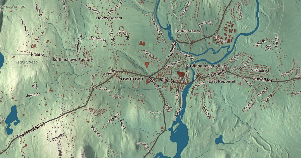
Pepperell sits where the Nissitissit River meets the Nashua, on the New Hampshire line. This map follows Nashua Road, River Road, Townsend Street, Main Street, Tarbell Street and South Road by name, and it prints Boutwell Island, the Nashua River Reservoir, Coon Tree Pond and Flat Pond in the water. Click here to purchase a print of this map for your wall.
Pepperell is in Middlesex County.
KNOWOL made this map in 2026 from public survey data and gave it the look of an old atlas. The hills and the river valley come from United States Geological Survey elevation data, and the streets and the town line come from the Census Bureau. Pepperell borders Brookline and Hollis, New Hampshire, to the north and Nashua to the northeast across the Nashua River, with Dunstable, Groton and Townsend on its other sides. It covers 23.2 square miles and had 11,604 people at the 2020 census.
Part of Groton
Pepperell began as part of Groton. The Town of Pepperell’s recorded history dates European settlement to 1720. The common at the center was laid out in 1740, along with the first church, whose site is still traced by foundation lines, and the village spreads out from the common along Park, Main, Elm, Townsend and Heald streets. The founders named the town for Sir William Pepperrell, who led the 1745 capture of the French fortress of Louisbourg. Pepperell was incorporated as a town in 1775. The town remains part of Middlesex County today. It was known for its good soil and orchards.
William Prescott, who owned a house in town, became colonel of a regiment of minutemen enrolled in Pepperell and nearby towns in 1774, and when the news of April 19, 1775, arrived about ten in the morning he sent the Pepperell company marching. Two months later he led 1,200 men onto the Charlestown peninsula to fortify Bunker Hill and commanded them in the battle there. He died in Pepperell and is buried in Walton Cemetery. According to a legend first published in 1899, while the men were away Prudence Wright led a guard of some 30 or 40 Pepperell women, dressed in their husbands’ clothes and armed with whatever they had, pitchforks included, and in April 1775 they stopped Leonard Whiting of Hollis, a Loyalist, at Jewett’s Bridge over the Nashua River and held him overnight in a Pepperell tavern. On March 19, 1777, the town’s Committee of Estimation paid the guard 7 pounds, 17 shillings and sixpence, and the town meeting minutes called it Leonard Whiting’s Guard, because women couldn’t openly be paid for that service.
Barzillai Lew, born free in Groton in 1743, came from a family that farmed on the west side of the Nashua River in what was then the Pepperell section of Groton; he sold the family farm in the mid-1760s. A cooper by trade and a gifted musician, he served as a fifer in a Groton company that marched north toward Canada, and at Bunker Hill he fought as a soldier, fifer and drummer. Around 1766 he bought the freedom of Dinah Bowman, and they married.
Mills and the railroad
By 1837 Pepperell had 1,586 people and three paper mills, and it also made palm leaf hats, boots and shoes. In 1848 the Worcester & Nashua Railroad was laid through East Pepperell along the Nashua River. Freight trains served the paper mill until 1981, and the Hollis Branch was abandoned in 1982; in 2001 the old rail bed was paved as part of the Nashua River Rail Trail, which runs through Pepperell on its way from Ayer to Nashua. The Lawrence Library, designed by Ernest Flagg and Walter B. Chambers, was built in 1901, and it holds Sidney M. Shattuck’s collection of stuffed birds.
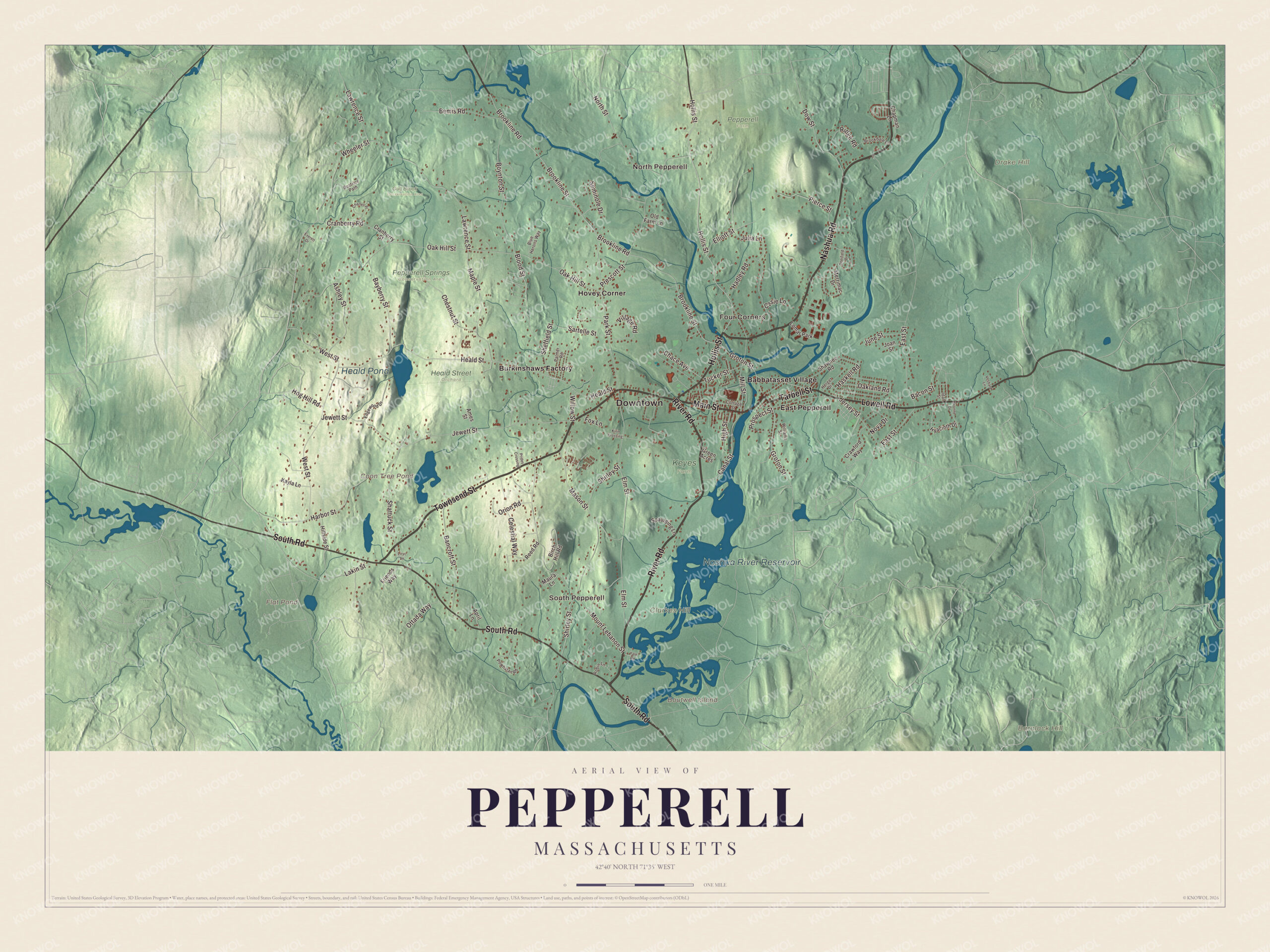
Click to explore a larger preview. The digital watermark does not appear on printed maps.
Names on this map
These names are printed on this map.
Places: Downtown, North Pepperell, South Pepperell, Four Corners, Baralock Hill, Boutwell Island, Clarkes Hill, Drake Hill, Coon Tree Pond, Flat Pond, Nashua River Reservoir, Heald Pond, Gulf Brook Conservation Area, Heald Street Orchard, Keyes Farm, Pepperell Farm, Pepperell Springs Conservation Area, Babbatasset Village, Burkinshaws Factory, East Pepperell, Hovey Corner and Lomar Park.
Streets and roads: Nashua Road, River Road, Townsend Street, Main Street, Tarbell Street, South Road, Lowell Road, Hollis Street, Groton Street, Bacon Street, Heald Street, Brookline Street.
More street names, A to Z
Ames Street, April Lane, Ashley Street, Bancroft Street, Bayberry Street, Beatrice Path, Bemis Road, Birch Hill Road, Blood Street, Blue Herons Way, Boynton Street, Brookdale Lane, Brookline Road, Canal Street, Casie Lane, Celestial Way, Chace Avenue, Chapman Lane, Charles Place, Chestnut Street, Cottage Street, Cranberry Road, Cranberry Street, Crawford Way, Deerfield Drive, Dow Street, East Street, Edgewood Drive, Elliott Street, Elm Street, Everett Drive, Fox Lane, Friends Way, Green Acres, Hadley Road, Harbor Street, Haskell Road, Herget Drive, High Street, Hillside Street, Hog Hill Road, Hyacinth Drive, Idal Street, Jersey Street, Jewett Street, Joan Street, Julia Lane, June Street, Kayla Lane, Kirin Krossing, Lakin Street, Lawrence Street, Liryc Lane, Maple Street, Mason Street, Maura Lane, Merrimac Drive, Mill Street, Mount Lebanon Street, North Street, Nova Drive, Oak Hill Street, Oakland Road, Old Farm Lane, Orion Road, Ottada Way, Palmer Road, Park Street, Pierce Street, Powhatan Road, Prescott Street, Prides Crossing, Prospect Street, Reed Road, Ridge Road, Robin Lane, Sartelle Street, Seminole Drive, Shattuck Street, Shawnee Road, Sheffield Street, Shirley Street, Spaulding Lane, Tucker Street, Vesbard Lane, Village Road, West Street, Wheeler Street, Williams Street, Willow Street, Yale Road, Yvonne Drive.
See it on a wall
The Pepperell map as a framed print. Swipe for more.


Around the map
Start with North Pepperell, then follow Nashua Road, River Road, Townsend Street, Main Street, Tarbell Street and South Road across town. Then look outward toward South Pepperell, Four Corners, Babbatasset Village, Burkinshaws Factory and East Pepperell. Boutwell Island, Coon Tree Pond, Flat Pond, the Nashua River Reservoir, Baralock Hill, Clarkes Hill and Drake Hill are all printed on the map. The covered bridge on Groton Street stands at the site where women on guard captured a British spy; it’s one of only three covered bridges on public Massachusetts roads open to cars, and the only one east of the Connecticut River. The present bridge opened on July 30, 2010, after the old Chester H. Waterous Bridge was taken down. The Nissitissit rises at Potanipo Pond in Brookline, New Hampshire, and joins the Nashua River in Pepperell.
The Pepperell map makes a fine addition to an office, library or den, and it can help teach children the geography and history of the river town of William Prescott and Prudence Wright. It’s made for people who call Pepperell home, from East Pepperell to the New Hampshire line, and it shows the town as it looks today. Zoom in on the preview above to explore the details, then click here to get your copy of the Pepperell, Massachusetts map.

Sources
- Pepperell, Massachusetts, Wikipedia
- Pepperell Center Historic District, Wikipedia
- William Pepperrell, Wikipedia
- William Prescott, Wikipedia
- Prudence Wright, Wikipedia
- Barzillai Lew, Wikipedia
- Nashua River Rail Trail, Wikipedia
- Nissitissit River, Wikipedia
- City and Town Incorporation and Settlement Dates, Secretary of the Commonwealth of Massachusetts (archived copy)