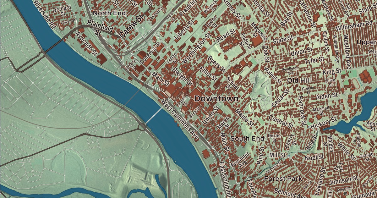
Springfield people know their city by its neighborhoods, and this map has them: Indian Orchard on the Chicopee River, Brightwood, East Springfield and East Forest Park, tied together by Main Street, Page Boulevard, Carew Street and the Boston Post Road, along with Watershops Pond and McCarthy Hill. Click here to purchase a print of this map for your wall.
Springfield is in Hampden County.
KNOWOL made this map in 2026 from public survey data and gave it the dignity of an old city atlas. United States Geological Survey elevation data shapes the bluffs and hills, and the streets and the city line come from the Census Bureau. Springfield covers 33.1 square miles on the east bank of the Connecticut River, near where the Westfield, Chicopee and Mill rivers join it, and the Connecticut state line is only 4 miles to the south. It’s the county seat, the largest city in western New England, and with 155,929 people at the 2020 census, the third most populous city in Massachusetts. Once nicknamed “The City in a Forest,” it keeps more than 4 square miles of parkland.
Agawam Plantation
The Agawam people lived here when the English came, and they sold land to the settlers. The Puritan William Pynchon founded the settlement in 1636 as Agawam Plantation, and in 1641 it was renamed for his hometown of Springfield in Essex, England, the first Springfield in the New World. The City of Springfield’s recorded history, in the Secretary of the Commonwealth’s list, dates European settlement to 1636. Springfield was incorporated as a town in 1636, and it was incorporated as a city in 1852. The first settlement, today’s downtown, sat on bluffs above the rivers where trade routes to Boston, Albany, New York and Montreal crossed. Court Square on Main Street, called “Springfield’s front door,” has been the city’s one constant landmark since its founding and is still its civic heart.
The City of Firsts
In 1777 George Washington approved the site of the Springfield Armory, recommended by his artillery chief, Henry Knox. It was the country’s first federal armory, it made the first American musket in 1794, and for nearly two centuries it drew skilled workers who made Springfield the nation’s longtime center for precision manufacturing. The armory closed in 1968, and its grounds are now the Springfield Armory National Historic Site. Its Water Shops stood on the Mill River at Watershops Pond, first called Lake Massasoit, which at 186 acres is Springfield’s largest body of water after the Connecticut River.
Springfield earned the nickname “The City of Firsts.” Merriam-Webster, publisher of the first American dictionary, is still here. The Duryea brothers built the first American gasoline-powered car in Springfield in 1893, and the Indian Motocycle company, founded here in 1901, was America’s first motorcycle brand. In 1891 Dr. James Naismith invented basketball in Springfield, and the Naismith Basketball Hall of Fame, which opened its first building here in 1968, now stands beside the Connecticut River. Theodor Geisel, Dr. Seuss, was born in Springfield, and a house on Mulberry Street inspired his first children’s book, And to Think That I Saw It on Mulberry Street. Bronze figures from his books fill the Dr. Seuss National Memorial Sculpture Garden at the Quadrangle, a campus of five museums beside the City Library. Before the Civil War, the abolitionist John Brown lived in Springfield and worshiped from 1846 to 1850 at the church now called St. John’s Congregational, where he met Frederick Douglass and Sojourner Truth.
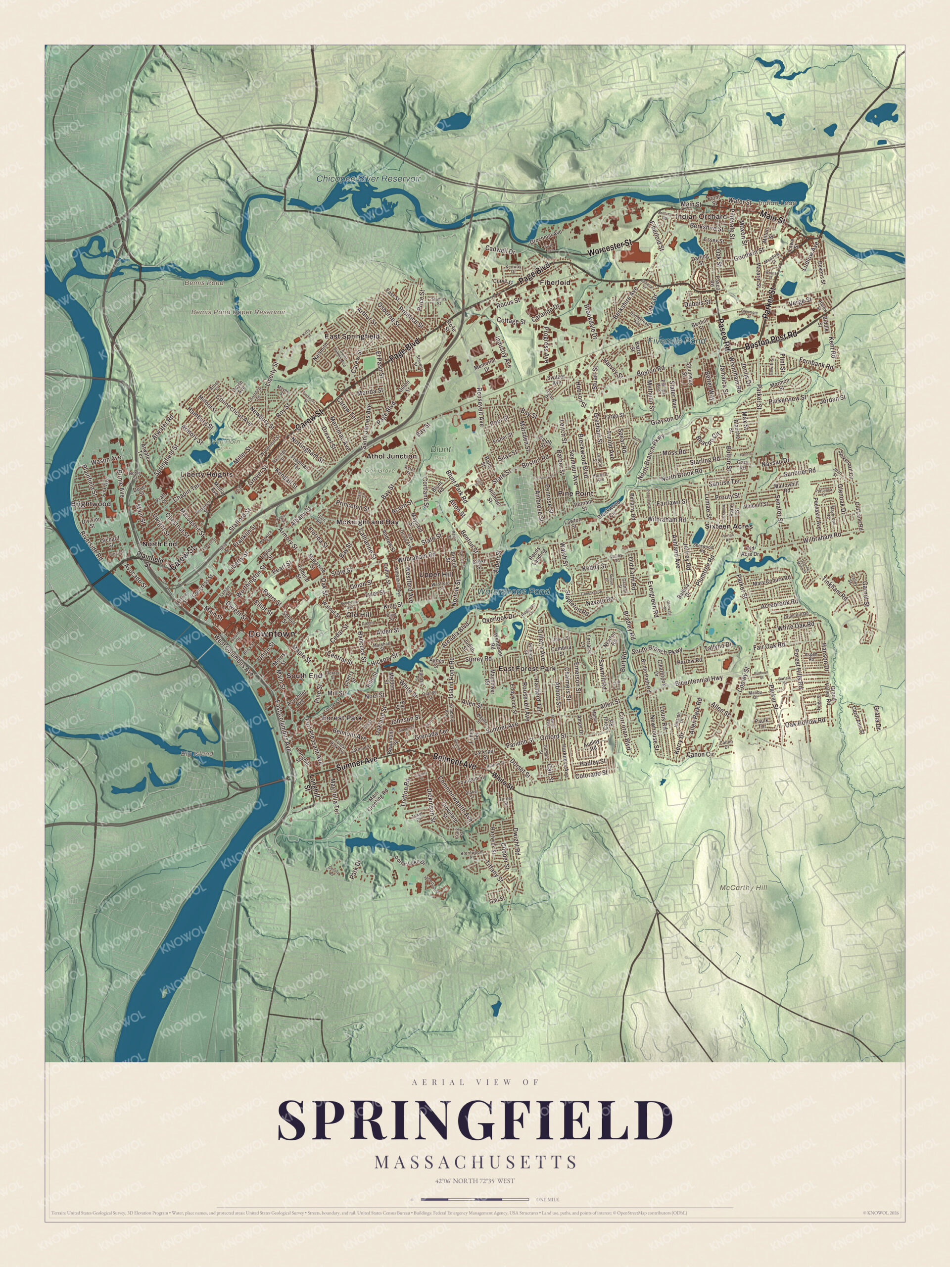
Click to explore a larger preview. The digital watermark does not appear on printed maps.
Names on this map
These names are printed on this map.
Places: Downtown, Indian Orchard, Big Island, Indian Leap, McCarthy Hill, Bemis Pond, Bemis Pond Upper Reservoir, Watershops Pond, Chicopee River Reservoir, Fivemile Pond, Blunt Park, Oak Grove Cemetery, Van Horn Park, Athol Junction, Brightwood, East Forest Park, East Springfield, Fiberloid, Forest Park, Liberty Heights, McKnight and Bay, North End, Old Hill, Pine Point, Sixteen Acres, South End and Upper Hill.
Streets and roads: Page Boulevard, Carew Street, Main Street, Pasco Road, Worcester Street, Boston Post Road, Parker Street, Sumner Avenue, Belmont Avenue, East Columbus Avenue, Plainfield Street, Pearl Street.
More street names, A to Z
Abbott Street, Acorn Street, Acrebrook Road, Acushnet Avenue, Agnes Street, Albany Street, Alden Street, Alderman Street, Allen Park Road, Allen Street, Alton Street, Ambrose Street, Amos Drive, Andrew Street, Arcadia Boulevard, Armory Street, Arnold Avenue, Arthur Street, Ashbrook Street, Ashland Avenue, Aspen Road, Aster Street, Athol Street, Atwater Road, Atwater Terrace, Audley Road, Avocado Street, Baird Trce, Balboa Drive, Balis Street, Barber Street, Barre Street, Bartels Street, Bay Street, Beacon Circle, Beaumont Street, Bellamy Road, Belle Street, Benton Street, Berkshire Avenue, Berkshire Street, Berlin Street, Better Way, Bexhill Street, Bicentennial Highway, Biddle Street, Birnie Avenue, Blaine Street, Blake Street, Blanche Street, Bliss Street, Blunt Park Road, Blunt Road, Bolton Street, Boston Road, Bradley Road, Breckwood Boulevard, Breckwood Circle, Brentwood Street, Bridle Path Road, Bristol Street, Brittany Road, Brookdale Drive, Burt Road, Byers Street, Cadwell Drive, Caitlin Drive, Calley Street, Cambria Street, Canon Circle, Carando Drive, Carew Terrace, Carlisle Street, Carol Ann Street, Carr Street, Catharine Street, Cedar Street, Central Street, Chalmers Street, Chapin Terrace, Cherokee Drive, Cherry Street, Chestnut Street, Clearbrook Drive, Colony Road, Colorado Street, Colton Street, Commonwealth Avenue, Congress Street, Connecticut Avenue, Cooley Street, Cooper Street, Coral Road, Corcoran Boulevard, Cortland Street, Cottage Street, Court Street, Craig Street, Crest Street, Curve Street, Darling Street, Devens Street, Dewitt Street, Dexter Street, Dickinson Street, Division Street, Dorset Street, Dover Street, Doyle Avenue, Drexel Street, Druid Hill Road, Dubois Street, Duffy Lane, Dwight Road, Dwight Street, Earl Street, East Street, Eddywood Street, Egan Drive, Elliot Street, El Paso Street, Embury Street, Emerson Street, Emery Street, Essex Street, Everett Street, Evergreen Road, Fairlawn Street, Fair Oak Road, Fargo Street, Federal Street, Fernbank Road, Fiberloid Street, Fisher Street, Fisk Avenue, Flint Street, Florida Street, Forest Hills Road, Forest Park Avenue, Fort Pleasant Avenue, Fountain Street, Franklin Street, Freeman Terrace, Front Street, Gail Street, Garfield Street, Garnet Street, Gary Road, Gifford Street, Gillette Avenue, Gilman Street, Glenmore Street, Glenoak Drive, Glen Road, Glenvale Street, Goodwin Street, Gralia Drive, Grand Valley Road, Grattan Street, Grayson Drive, Greene Street, Grenada Terrace, Gresham Street, Grochmal Avenue, Groveland Street, Grover Street, Guion Street, Hadley Street, Hall Street, Hamburg Street, Hancock Street, Hanson Drive, Hardy Street, Harkness Avenue, Harrow Road, Hartford Terrace, Hartwick Street, Harvey Street, Hastings Street, Herbert Avenue, Hickory Street, Hillmont Street, Hillside Drive, Hobson Street, Homestead Avenue, Industry Avenue, Ionia Street, Island Pond Road, Ithaca Street, Jamaica Street, Jamestown Drive, Jeanne Marie Street, Jeffrey Road, Jerilis Drive, Joan Street, Johnson Street, Jordan Street, Judith Street, Kane Street, Keddy Street, Kendall Street, Kent Road, Kenway Drive, Kerry Drive, Kimberly Avenue, King Street, Kirby Street, Lake Drive, Lamont Street, Larkspur Street, Lawe Street, Lawton Street, Leitch Street, Liberty Street, Locust Street, Longhill Street, Louis Road, Lowell Street, Ludlow Avenue, Lumae Street, Lyman Street, Magazine Street, Magnolia Terrace, Main Greeting Road, Malden Street, Malibu Drive, Mallowhill Road, Manor Court, Maple Street, Marmon Street, Marsden Street, Marshall Street, Mary Coburn Road, Massasoit Street, Max Street, Maybrook Road, Mayflower Road, Mayher Street, Maynard Street, Mazarin Street, Meadow Street, Melba Street, Melha Avenue, Memorial Drive, Merida Street, Merrimac Avenue, Methuen Street, Milford Street, Miller Street, Mill Street, Milton Street, Morris Street, Moss Road, Moxon Street, Naismith, Napier Street, Nassau Drive, Navajo Road, Newbury Street, Newhouse Street, Newton Road, Noble Street, Noel Street, Norfolk Street, North Branch Parkway, North Brook Road, Nottingham Street, Nye Street, Oak Grove Avenue, Oak Hollow Road, Oakland Street, Oak Street, Old Acre Drive, Old Farm Road, Old Lane Road, Olive Street, Orange Street, Orchard Street, Osborne Street, Overlook Drive, Paridon Street, Park Drive, Parkerview Street, Paulk Terrace, Peekskill Avenue, Peer Street, Pendleton Avenue, Penrose Street, Phillips Avenue, Piedmont Street, Pine Street, Pinevale Street, Pineview Drive, Plumtree Road, Porter Lake Drive, Portulaca Drive, Powell Avenue, Pratt Street, Prentice Street, Price Street, Princeton Street, Progress Avenue, Prospect Street, Prouty Street, Puritan Road, Putnam Street, Ralph Street, Randall Place, Reeds Landing, Ridgeway Circle, Rifle Street, Riverside Road, Rocus Street, Roosevelt Avenue, Rose Street, Roy Street, Ruthven Street, Saint James Avenue, Sawmill Road, School Street, Scott Street, Senator Street, Seneca Street, Seymour Avenue, Sherwood Road, Shumway Street, Silas Street, Sixth Avenue, Slater Avenue, South Branch Parkway, Spear Road, Spikenard Circle, Springfield Street, Stafford Street, Stanley Street, Stapleton Road, Starling Road, State Street, Stevens Street, Stuart Street, Sunbrier Road, Sunrise Terrace, Sunset Drive, Surrey Road, Switzer Avenue, Tallyho Drive, Taylor Street, Terrace Lane, Texel Drive, Thornfell Street, Tiffany Street, Tinkham Road, Tioga Street, Trafton Road, Trinity Terrace, Turner Street, Tyler Street, Union Street, Valley Road, Vann Street, Verge Street, Vincent Street, Virginia Street, Walnut Street, Walsh Street, Warwick Street, Wason Avenue, Water Street, Wayne Street, Wendover Road, West Columbus Avenue, Westford Avenue, Westford Circle, White Oak Road, White Street, Whittier Street, Wilbraham Avenue, Wilbraham Road, Woodmont Street, Worthington Street, Wrentham Road, Wrona Street, Yale Street.
Around the map
Start with Indian Orchard. Follow Page Boulevard, Carew Street, Main Street, Pasco Road, Worcester Street and the Boston Post Road across the city. Then look outward toward Athol Junction, Brightwood, East Forest Park, East Springfield and Fiberloid. Bemis Pond, Bemis Pond Upper Reservoir, Watershops Pond, Chicopee River Reservoir, McCarthy Hill and Big Island are all printed on the map. Indian Orchard began in the 1840s as a mill town on the Chicopee River, with many French Canadian workers, and one of its old mills is now a large artists’ studio space; its First Congregational Church of 1863 is the city’s third-oldest church. East Springfield is a residential, working-class neighborhood, and the Boston Road neighborhood takes its name from the old Boston Post Road. Brightwood holds many Baystate Health buildings. In the southwest corner of the city, the 735-acre Forest Park is surrounded by garden districts of Victorian houses, and East Forest Park is a mostly middle-class neighborhood on the East Longmeadow line.
The Springfield map makes a fine addition to an office, library or den, and it can help teach children the geography and history of the City of Firsts. It’s made for people who call Springfield home, from Indian Orchard to East Forest Park, and it shows the city as it looks today. Zoom in on the preview above to explore the details, then click here to get your copy of the Springfield, Massachusetts map.

We made a map for every town and city in Massachusetts. Explore the complete Massachusetts map collection and find your town.
Sources
- Springfield, Massachusetts, Wikipedia
- Springfield Armory, Wikipedia
- Watershops Pond, Wikipedia
- Indian Orchard, Springfield, Massachusetts, Wikipedia
- Naismith Basketball Hall of Fame, Wikipedia
- City and Town Incorporation and Settlement Dates, Secretary of the Commonwealth of Massachusetts (archived copy)